Description
Ascent to Peak Peredovoy via the Northwest Edge (First Ascent of the Route)
Geographical Information
Peak Peredovoy (6056 m) is located in the uppermost part of the Fedchenko Glacier area, in the northwest spur of the Yazgulemsky Ridge, which branches off to the northwest opposite Peak 26 Baкинских Commissars (see diagram).
The northeastern slopes of the spur are steep and hidden by hanging glaciers; the western slopes are less steep and composed of shattered rocks and steep glaciated scree, most of which is covered with snow. The northwestern end of the spur drops steeply towards the Fedchenko Glacier (see photograph of the general view of Peak Peredovoy).
The upper reaches of the Fedchenko Glacier have relatively gentle relief with a large number of hidden crevasses. Near the end of the spur, the crevasses are wide and open.
Before the ascent described, Peak Peredovoy was climbed twice: by Dobrynin's group (August 12, 1960) and by Miklevich's group, which ascended Peak 26 Baкинских Commissars. Both times the ascent was made from the western slopes - the easiest route for ascent - rated 3B category of difficulty.
Approaches
The approaches to Peak Peredovoy were made via the following route.
From the Lower Base Camp (altitude 3900 m), located on the shore of a lake at the confluence of the Kaskadny Glacier with the Abdukagor Glacier, to the Upper Base Camp on the Fedchenko Glacier (altitude 5000 m) and further to the camp under Peak Revolyutsii (from which the ascent to Peak Revolyutsii by Myshlyaev's group was observed); see diagram.
The exit to the Fedchenko Glacier was made through the Abdukagor Pass (altitude 5100 m). The path to the Abdukagor Pass went along the left side of the Abdukagor Glacier. The icefall was traversed also on the left side of the glacier, and higher up, mainly in its middle part.
The Abdukagor Glacier in the second half of summer may present great difficulties when passing through it. In its middle part, a large number of crevasses have to be circumvented. Higher up, the glacier is closed, but also with a large number of crevasses, so it is necessary to proceed to the pass only in rope teams and with great caution.
The ascent from the Lower Base Camp (3900 m) to the Upper Base Camp (5000 m) took one day (about 10 hours).
The approaches from the Upper Base Camp to the camp under Peak Revolyutsii went through the middle part of the Fedchenko Glacier, approaching its right bank and then eastwards, in the direction of Peak Grin.
The Fedchenko Glacier:
- abounds in hidden crevasses, posing a great danger;
- especially in the second half of August, towards the end of the day, snow bridges become unreliable;
- was traversed in rope teams;
- movement can be significantly facilitated with the help of skis.
This part of the approach takes another day (about 5-6 hours).
Ascent
On August 17, 1962, the participants of the ascent descended to the foot of the northwest edge of Peak Peredovoy at 5:00. The descent was made on skis and took about 30 minutes.
For the convenience of describing the ascent route, it is divided into sections, also marked on the profile diagram and on the photographs of the summit.
R1. The ascent begins on a steep, large scree in the direction of the couloir. First on the right side, then on the left; then into the couloir with sheer walls, and upwards, pressed to the left wall until exiting the couloir. This section is prone to rockfall and must be traversed before the ridge is illuminated by the sun. Along a wide ledge, traversing the wall, we emerge onto severely shattered rocks of medium difficulty. Insurance is alternated through ledges. We reach a chimney with stone plugs. We ascend the chimney onto overhanging rocks. This is the most technically challenging rock section of the route, requiring about 2 hours and 30 minutes of intense work. Insurance is provided through ledges and pitons hammered into the rocks.
R2. The chimney leads to a shoulder. Further, there are rocks of medium difficulty and a severely shattered steep ridge with small gendarmes, which are easily bypassed.
R3. The ridge leads to high gendarmes with a characteristic sharp summit. We traverse to the right, then cross a shallow depression, and from the southwest side, we ascend to the summit of the gendarme. Here, a control cairn is built with "photo No. 1".
R4. After the gendarme, the path passes almost along a horizontal and wide ridge composed of severely shattered rocks. The northeastern slopes are snow-ice; the western slopes are covered with large scree and drop off with large rocks lower down.
R5. We bypass a sharp gendarme (finger) on the right via scree and then approach an sheer wall via rocks and snow (see photo No. 2). The wall is about 60 m high.
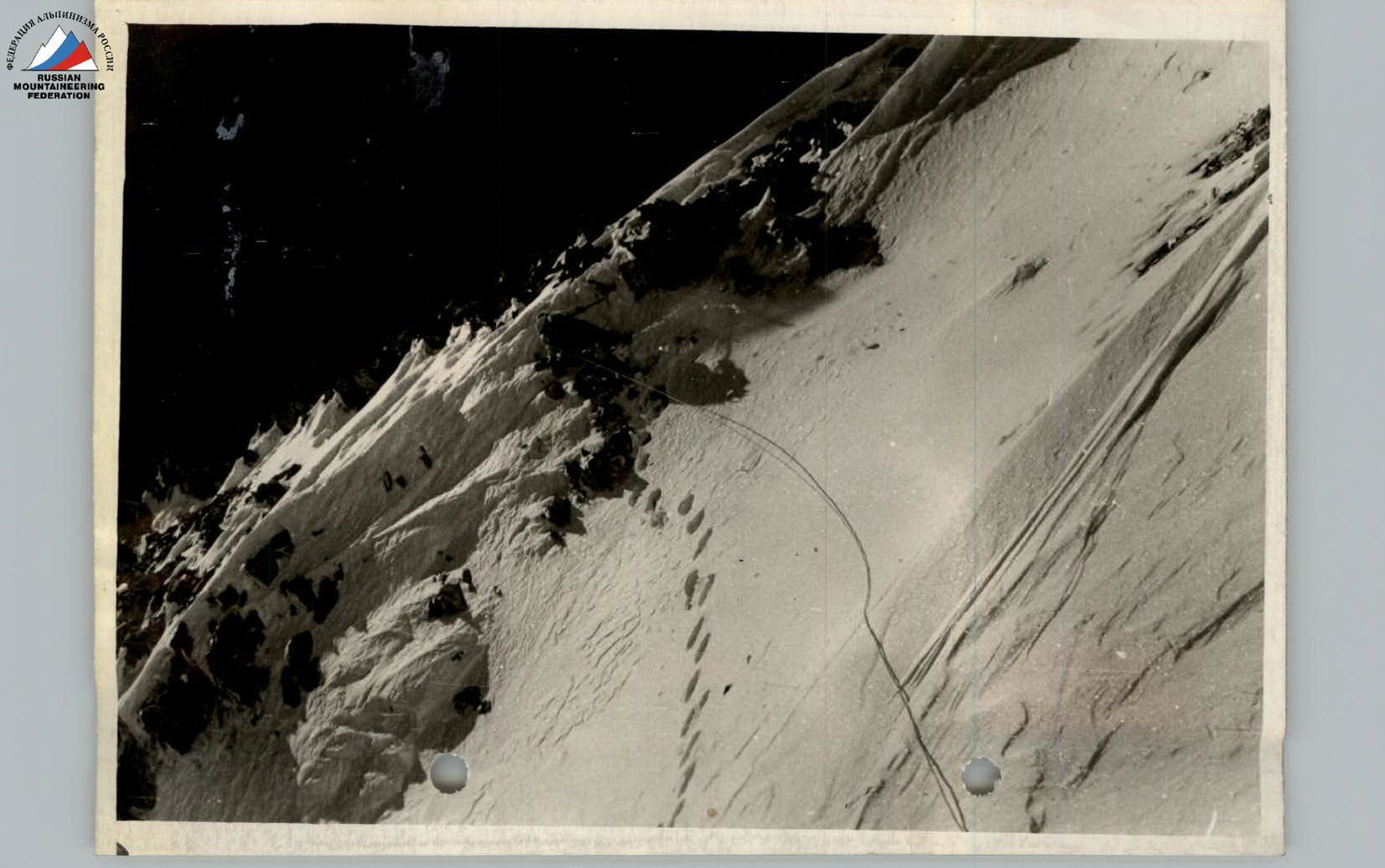
R6. The wall is bypassed on the left (photo No. 3) via a very steep snow ascent (photo No. 4), which leads to an even steeper northeastern slope of the ridge (see photo No. 5). The passage of this section requires great caution, as there is an ice drop of a hanging glacier below. Intermediate insurance is organized on a sharp rock outcrop protruding from the snow slope (approximately in the middle of this section) (photo No. 5).
R7. We emerge onto a snow ridge with deep snow. The section does not present technical difficulties.
R8. Ascent via easy rocks. Due to the presence of frozen snow and the absence of convenient rock outcrops for insurance, a piton has to be hammered in one place for insurance.
R9. Steep snow ascent (about 80 m).
- On the western side, the snow cornice drops into an abyss.
- Caution and thorough insurance are required.
- Under the unreliable, breaking snow crust - loose snow, greatly hindering ascent.
- Closer to the rocks - the layer of snow is thinner, but ice is encountered (see photo No. 6).
R10. The ridge, along which the further path lies, features:
- Sections of easy rocks, covered with snow.
- Scree, exposed on the southwest side.
- Snow ascents.
There were no technical difficulties when passing this section (photo 7).
R11. Ascent of the ridge.
- Rocks are severely shattered.
- Snow covering them has poor adhesion to the rocks in the middle of the day.
- Caution and insurance are required during movement.
R12. After emerging onto a snow shoulder, the ascent begins on a sharp and steep snow ridge with a cornice in its upper part (photo 8).
R13. After a shallow dip in the snow ridge, the path is blocked by an outcrop of:
- Steep, severely shattered rocks.
- Cemented by frozen snow.
- Covered with snow on top.
Clearing ice and snow with an ice axe and cutting steps were required (photo No. 9).
R14. The route passes along a steeply falling snow ridge with a cornice overhanging to the left. In the middle of the ridge, a rock tower rises, which is bypassed on the left along the cornice. (See photograph of the route, section R16).
Behind the rock tower, there is a convenient resting area on the ridge.
R15. After a steep and narrow snow ascent of the ridge with rock outcrops (photo No. 10), the ridge becomes significantly wider and less steep (see photograph of the route, section R17).
R16. A long and wide snow ridge, with rare and insignificant rock outcrops, leads to the summit. (Photo 11).
The summit is snowy, with a large cornice on the northern side. The cairn is located somewhat below the highest point of the summit, on a snow-free area of shattered rocks.
The group reached the summit at 15:30. A note from A. Miklevich's group was retrieved.
Descent
The group began descending from the summit at 16:00. The descent route initially followed the ascent route; approximately in the middle of the ridge (section R12), the direction of descent was changed towards the southwest slope.
The descent proceeded via the following route:
- from the ridge, the group descended along a steep counterfort to a rock step;
- transitioned into a couloir;
- then emerged onto a steep snow slope, along which they descended to the glacier.
During the descent, caution was necessary, as ice was encountered in some places. The descent to the place where skis were left was completed by 19:15.
At 20:30, the group returned to the overnight camp under Peak Revolyutsii.
Comparing the route taken with the routes of previous ascents in this and other areas, the group evaluates it as a 4B category of difficulty route.
Time calculation for the ascent (including approaches)
| First day: | Lower Base Camp – Fedchenko Glacier | 10 hours |
| Second day: | Upper Camp (on Fedchenko Glacier) – overnight stay under Peak Revolyutsii | 8 hours |
| Third day: | Overnight stay under Peak Revolyutsii – summit – overnight stay | 13 hours |
| Including: ascent | 8 hours 30 min | |
| descent | 4 hours 30 min | |
| Fourth day: | Return to Lower Base Camp | 12 hours |
| Total | 43 hours |
List of participants in the ascent to Peak Peredovoy via the northwest edge
| Last name, first name, patronymic | Rank | Home address |
|---|---|---|
| 1. PEKARSKY Valentin Vsevolodovich | P | Dushanbe, Popova 118, apt. 12 |
| 2. LINDT Ivan Ivanovich | P | Dushanbe, Ain Street, No. 70 |
| 3. GUYVAN Alexander Ivanovich | P | Kiev |
The description was compiled by:
- PEKARSKY V. V.
- LINDT I. I.

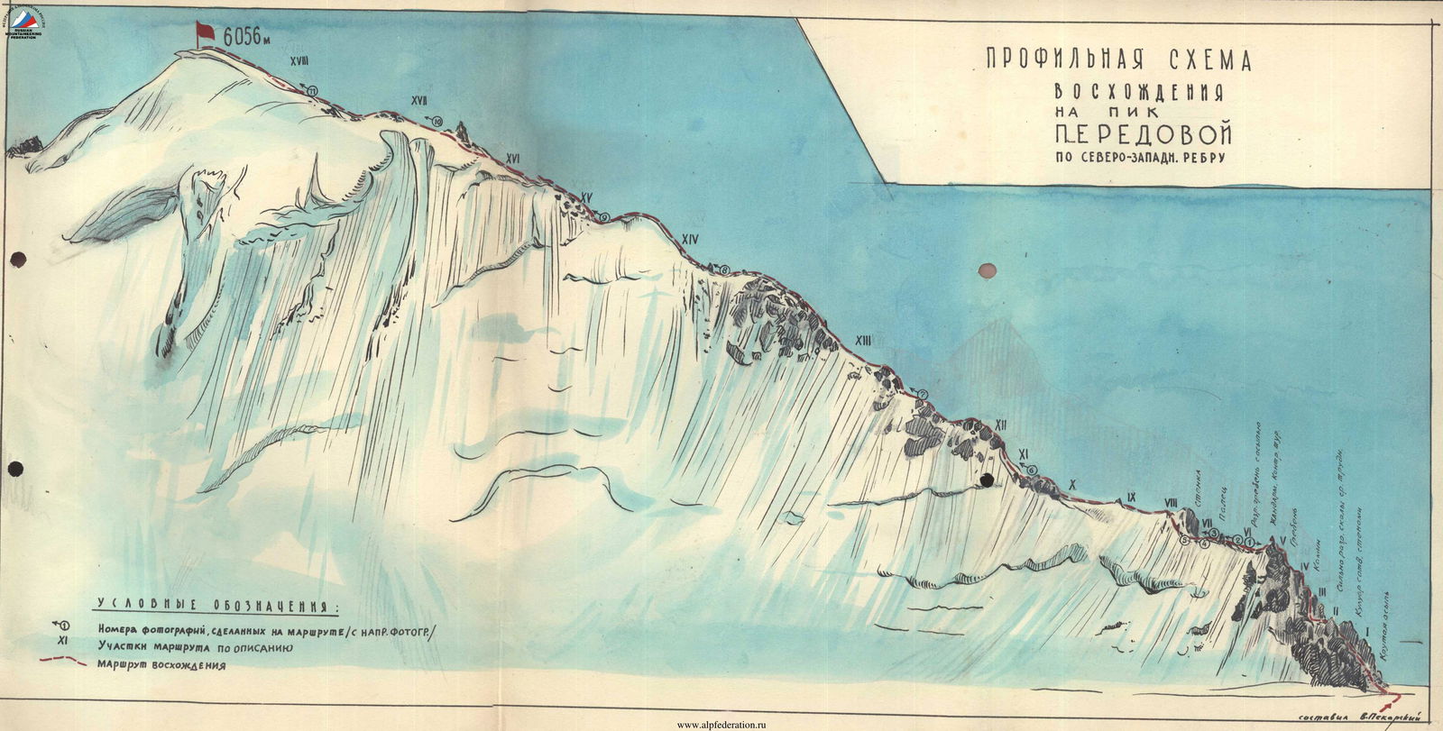
Profile diagram of the ascent to Peak Peredovoy via the northwest edge
Legend
- Numbers of photographs taken on the route (with direction of photography)
- Sections of the route according to the description
- Route of ascent