
23
Climbing passport. Climbing category — high-altitude technical. Climbing area — Central Pamir, Khavraz-Dara valley. Peak, its height, route — p. Yu. Manoylova 5870 m via NE wall. Proposed 5B category of difficulty, first ascent.
Route characteristics:
- height difference — 1670 m
- length of sections with 5–6 category of difficulty — 840 m
- average steepness of the main part — 70°
- wall length — 1025 m
Pitons driven:
- Rock 82/6
- Bolt 0/0
- закладные 28/4
- Ice 6/0
Climbing hours: 28.5 hours. Overnight stays: I bivouac. Leader: Botov Dmitry Alexandrovich — 1st sports category Participants:
- Konovalov Yury Viktorovich — Candidate Master of Sports
- Moroz Vladislav Pavlovich — Candidate Master of Sports
- Ivanovsky Vitaly Borisovich — Candidate Master of Sports Coach: Vasilyev Boris Petrovich — Master of Sports of International Class
Departure to the route: August 6, 1984. Summit reached: August 7, 1984. Return: August 8, 1984.
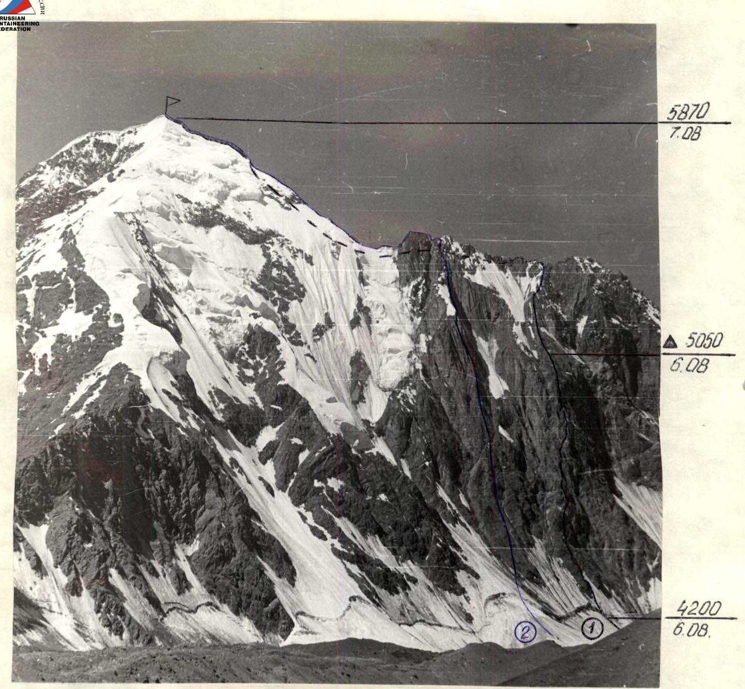
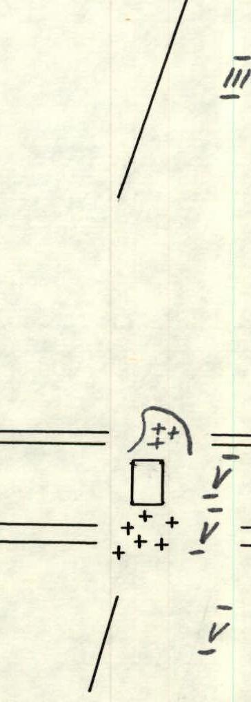
- General photo of the summit.
Taken on August 5, 1984. Shooting point #1. Shooting height 4000. Lens "Helios-44". (1) route climbed by the group. (2) route of 1980 by LOS DSO "Trud".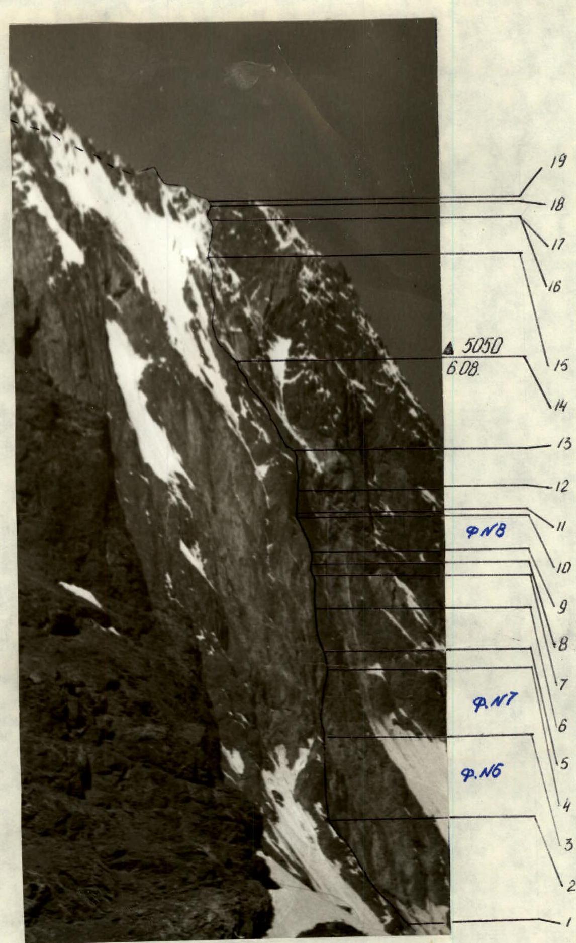
- Profile of the left wall.
Shooting point #2. Shooting height 4150. Lens "Helios-44".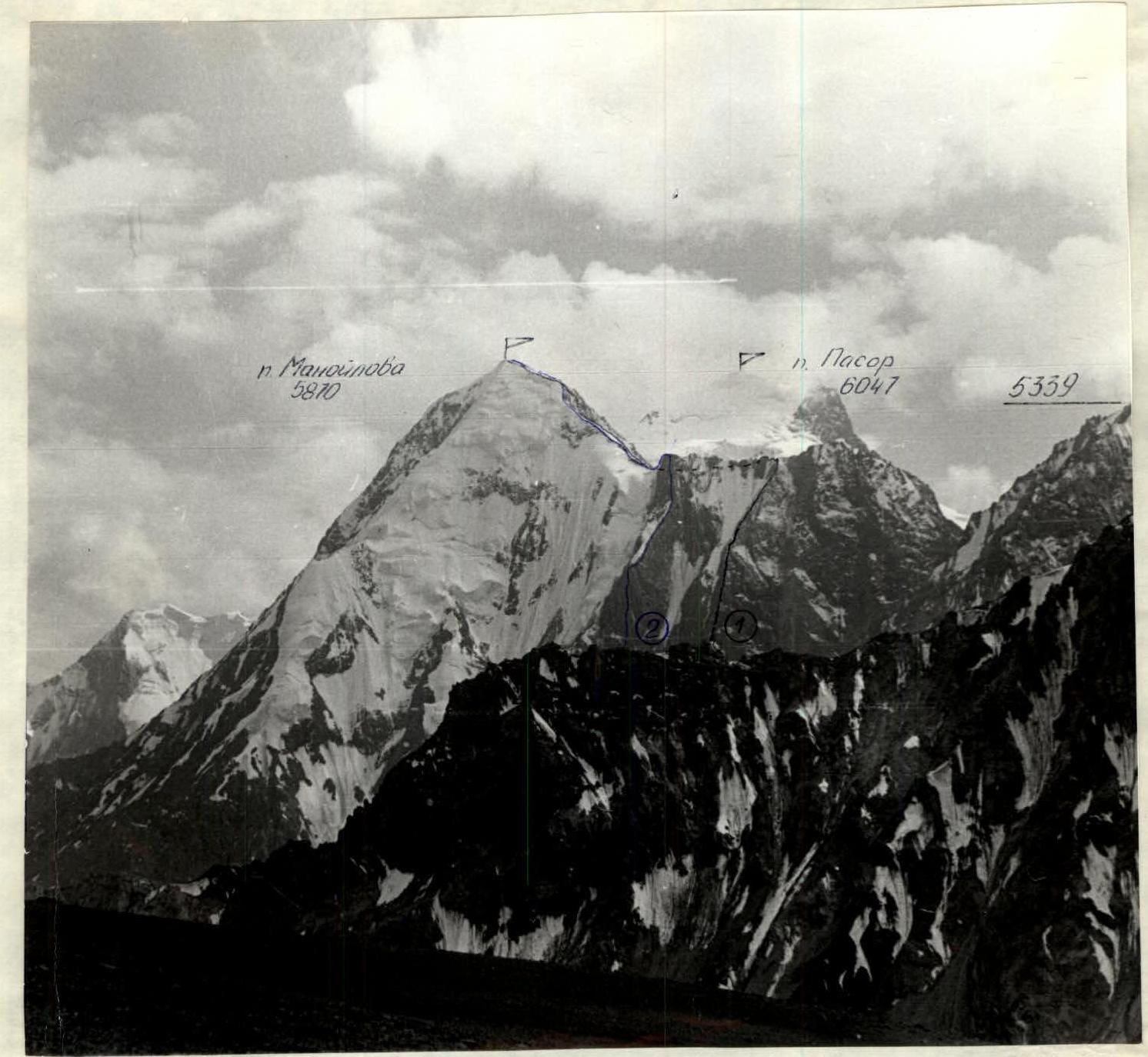
- Photopanorama of the area.
Shooting point #3. Taken from a height of 4600. Lens "Helios-44". (1) visible part of the route climbed by the group. (2) visible part of the route by the team of LOS DSO "Trud".
Brief overview of the climbing area.
The Khavraz-Dara valley is located in the eastern part of the Central Pamir, east of the Grumm-Grzhimailo glacier. The valley stretches from south to north for about 30 km, starting from the Passor village, two hours walk from the Kudara village, which lies in the upper reaches of the Rushan valley at the confluence of the Tanymas and Kokuy-Bel-su rivers.
At the head of the valley, at an altitude of 3990 m, there is a large lake of the same name.
To the west, the valley is framed by peaks up to 6000 m high with steep walls.
Our team paid attention to the logical route to p. Yu. Manoylova via the NE wall, passing along the buttress to the right of the route climbed by the team of LOS DSO "Trud" in 1980 under the leadership of V. A. Solonnikov. The NE wall of the summit drops off with a kilometer-high sheer face to the glacier. The average steepness of the wall is 70°. Its central, most difficult part, 340 m long, has an average steepness of 80°. The rocks are of varying degrees of disrepair. The relief is diverse. The route is quite safe, limited on the left by a chute-couloir and on the right by an area prone to rockfall caused by a mulde in the upper part of the wall. The nature of the route does not allow one to relax for a minute.
Peak Yu. Manoylova is located between the peaks 6047 and 5539. You can approach the NE wall by ascending the valley to Lake Khavraz-Dara. After climbing the last moraine before the lake, turn left towards the saddle between peaks 5870 and 5539. Here, on the glacier, there are moraine islands where it is possible to set up a bivouac under the wall.
Path from Passor village:
- Along the trail to the moraine in front of the lake — 7–8 hours.
- Along the moraine left up to the wall — another 1.5 hours.
Tactical actions of the team. Based on the materials of the first ascenders, observations of the route, and taking into account the fairly high qualification and good acclimatization of the group members (in July, the team conducted a gathering in the Ak-Su area), the following ascent plan was drawn up:
Passage of sections:
- Day I — Part of the wall to the "tooth"
- Day II — Beginning of the buttress — ridge
- Day III — Ridge — summit — pass between p. 5870 and p. 5539
- Day IV — reserve in case of bad weather
Overnight stays:
- Saddle between the "tooth" and the wall
- On the ridge
- Pass
During the ascent, there were deviations from the planned tactical plan, as the group was able to cover a larger section, and the condition of the ridge was more favorable than that of the first ascenders (absence of snow and good weather).
The first on the route worked with a lightened backpack, and on the wall — without a backpack. The weight of the backpacks was minimized. The weight of the backpacks was reduced by:
- Individual tailoring of equipment and backpacks from the lightest and most durable materials.
- Use of titanium gear.
- Selection of light and high-calorie food.
The group divided into rope teams as follows:
- Botov — Ivanovsky
- Moroz — Konovalov
Up to section R11–R12, Konovalov worked first, then up to section R16–R17 — Moroz, and the rest of the route — Botov.
On the first day, a half-hour rest was made at the planned overnight stay near the "tooth". Hot tea and a snack were prepared. This noticeably gave strength, and the group was able to work in the same style until the overnight stay.
Radio communication with the base camp was provided three times a day. The route and the actions of the climbers were clearly visible from the camp with the help of optical instruments.
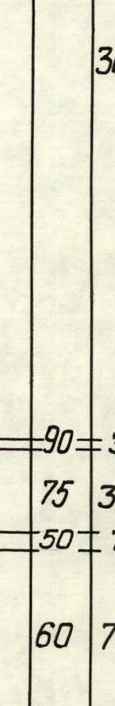
| № | Rock Pitons | Ice Pitons | закладные elements | Nature of relief | Avg. steepness, ° | Length, m |
|---|---|---|---|---|---|---|
| 1 | 1 | - | 6 | V | 75 | 80 |
| 2 | 3 | - | 2 | V | 65 | 45 |
| 3 | 2 | - | 1 | V | 80 | 25 |
| 4 | 3 | - | 2 | V | 85 | 45 |
| 5 | 6 | - | 3 | V, A1 | 85 | 80 |
| 6 | 8 | - | - | IV | 50 | 140 |
| 7 | - | - | - | III | 45 | 100 |
| № | Rock Pitons | Ice Pitons | закладные elements | Nature of relief | Avg. steepness, ° | Length, m |
|---|---|---|---|---|---|---|
| 8 | 15 | - | 1 | V | 65 | 150 |
| 9 | - | - | - | Departure at 5:30. Stop for bivouac at 22:00. Total 16.5 climbing hours. Overnight stay sitting. | - | - |
| 10 | 8 | - | - | V | 65 | 90 |
| 11 | 8 | - | 2 | V | 85 | 40 |
| 12 | 4 | - | 3 | V | 85 | 30 |
| 13 | 6 | - | 2 | V | 75 | 80 |
| 14 | 3 | - | 1 | V, A1 | 90 | 30 |
| 15 | 7 | - | - | V, A1 | 85 | 40 |
| № | Rock Pitons | Ice Pitons | закладные elements | Nature of relief | Avg. steepness, ° | Length, m |
|---|---|---|---|---|---|---|
| 16 | - | - | - | Departure at 8:00. Summit reached at 20:00. Total route length — 2190 m. Climbed in 28.5 hours. | - | - |
| 17 | 3 | 2 | 2 | III–IV | - | 800 |
| 18 | - | - | - | III | - | 300 |
| 19 | - | - | 1 | V | 90 | 30 |
| 20 | - | - | 3 | V | 75 | 30 |
| 21 | - | - | - | V | 50 | 7 |
| 22 | 5 | 2 | - | V | 60 | 70 |
       | ||||||
       |
continue work. Further, an inner corner 30 m (R11–R12) leads to an inclined shelf in front of the wall with good cracks for pitons, but difficult to pass (R12–R13). Then the beginning of the buttress, at first quite steep and then somewhat flattening out. The buttress is a chain of alternating small walls and inclined narrow shelves of various lengths (R13–R14). On one of these shelves, it was decided to set up an overnight stay at 22:00. Three people settled in a sitting position in a tent, one participant a little lower on a narrow saddle.
August 7, 1984. Departure at 8:00. Overcoming alternating small walls (R14–R15) and exiting to a vaguely expressed ridge (R15–R16). Then along the ice slope (R16–R17) under a rock ascent (R17–R18). Before reaching the ridge, it is necessary to overcome an ice cornice (R18–R19). At 18:00, the group reached the ridge. Along the heavily destroyed ridge (R19–R20), the group approached under a steeper pre-summit ridge (R20–R21). In the middle of the ridge, one has to overcome a 60 m wall; a detour to the left is avalanche-prone. At 20:00, the group reached the summit. Descent to the south side, first along the ridge along the ascent route, then along the talus to the glacier and along the glacier to the saddle. Overnight stay here.
August 8, 1984.
At 5:00, before dawn, the descent to the base camp began. The descent from the saddle is prone to rockfall. With the first rays of the sun, the occurrence of rockfalls increases. At 10:00, the group was in the base camp.
- Technical photograph of the route.
Shooting point #4. Shooting height 4150. Lens "Helios-44".