VT8
USSR ALPINISM FEDERATION (врedo тр9) USSR ALPINISM CHAMPIONSHIP 1973
REPORT
on the first ascent to the summit of Lyap-Nazar (5984 m) via the northeast wall Alpclub "Donbass"
Captain and coach M.S.SIVTSOV B.G.
DONETSK–1973
M.S.SIVTSOV B.G.
DONETSK–1973
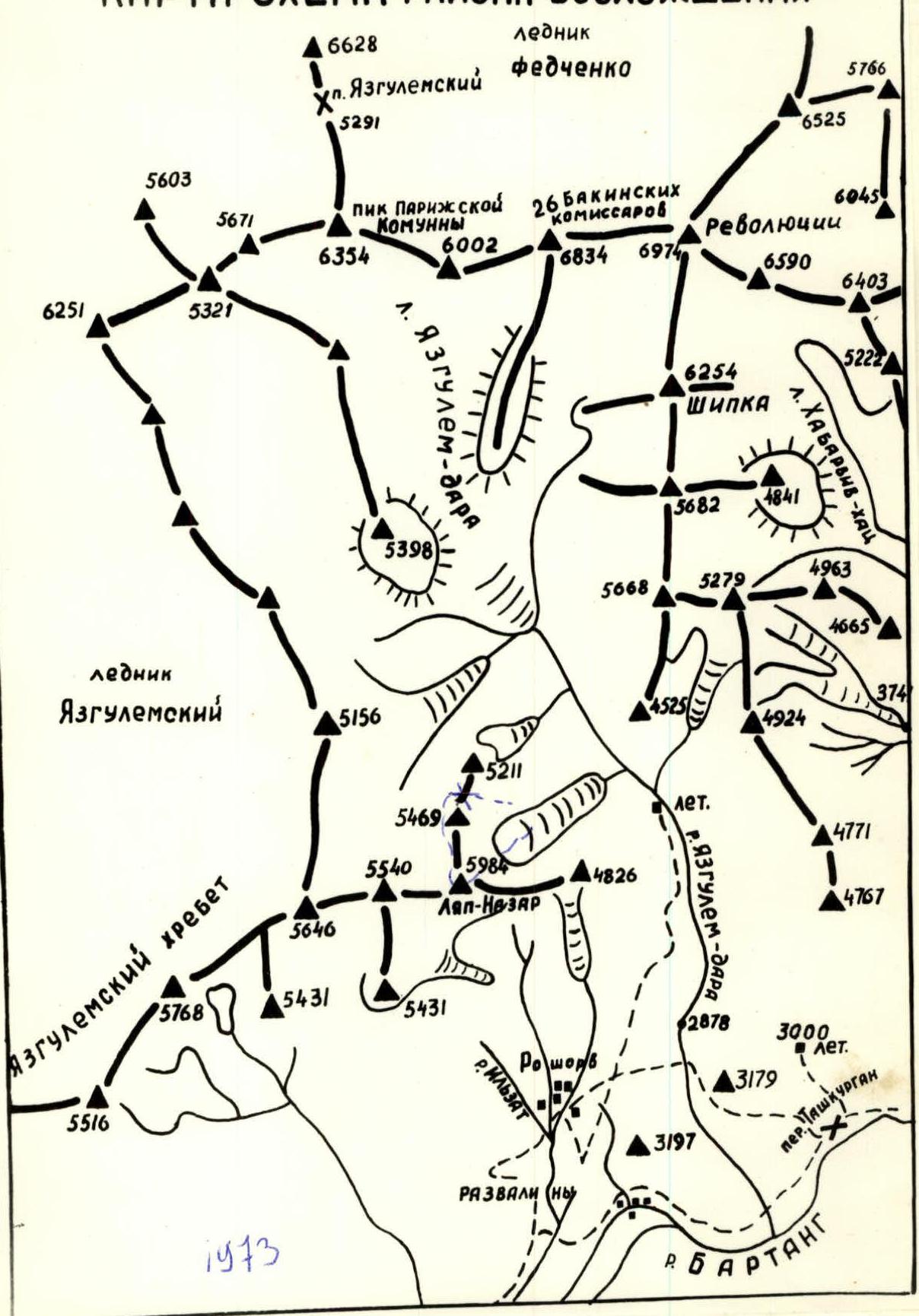
GEOGRAPHICAL LOCATION AND SPORTING CHARACTERISTICS OF THE LYAP-NAZAR SUMMIT (5984 m)
The Lyap-Nazar summit (5984 m) translates from the Rushani dialect as "Visible Tooth" (Lyap-tooth, Nazar-view). It is located at the eastern end of one of the Yazgulem Ridge spurs and stands out among neighboring peaks with its impressive "height". The southern walls of Lyap-Nazar drop steeply towards the Bartang River above the Roshorv village.
An 8-hour ascent from the village up the Yazgulem-dara River leads to the confluence of the Lyap-Nazar Glacier stream and Yazgulem-dara. The Northeast wall of Lyap-Nazar rises 2400 m above the glacier. For the past 4 years, the wall has attracted climbers with its inaccessibility and beauty, but expeditions focused on higher mountains in the area, such as Peak Revolyutsii and the 26 Baku Commissars, left this wall untouched, and until 1973, there were no attempts to ascend it.
The wall is largely rocky and dust-free. The most logical and safe route appears to be through the center of the northeast wall, assessed as a high difficulty category.
AREA MAP-SCHEME OF THE ASCENT
ASCENT CONDITIONS IN THE AREA
Climbers face the greatest challenges on the rocks in the lower part of the route and above the midpoint.
From 7:00 to 13:00, the wall is sunlit, and numerous waterfalls are visible. During the active snow and ice melting period, rockfalls occur continuously to the left and right of the wall's center.
The upper part of the wall, the "crown," is snowy, with steep ice gullies and couloirs visible. The "crown" is topped with massive snow cornices.
The area around Peak Revolyutsii and Lyap-Nazar is quite far from populated areas. It takes 6 hours to walk down to the nearest village, Roshorv, from the expedition's base camp along the trail above the Yazgulem-dara River.
In the 1973 season, the path along the Bartang River to the regional center of Rushan was practically impassable due to the swollen river. Usually, this journey takes 2-3 days. Rushan is connected to Dushanbe, a station in the Tajik SSR, by Aeroflot. The Dushanbe-Rushan road operated intermittently due to flooding and washed-out bridges.
To the east, a road leads through the Tashkurgan pass to Murghab. The nearest mountaineering bases to our ascent area are the "Vyssotnik" climbers' base in Osh and the ascent area at the base camp - the area around Peak Engels and K. Marx in the Southwest Pamir.
In 1968-1969, army climber expeditions worked in the area around Peak Revolyutsii, followed by Tomsk in 1969, and "Trud" in 1970. Weather conditions in the area are good, with sunshine, light cloud cover, and wind, occasionally strong. It is cool.
The geology of the area is complex, with mainly complex intrusive rocks and rare outcrops of granite, sandy-limestone schist, and marbleized rocks.
ROUTE PROGRESSION
July 30
The group departed from the base camp as planned and, descending down the Yazgulem-dara gorge, reached the foot of the wall (3600 m) on the Lyap-Nazar Glacier in 4 hours. They set up a bivouac and stopped for the night.
July 31
At 8:00, the team of Zhelobotkin P.I. and Radashkevich E.A. started processing the lower part of the wall from the assault camp. Having processed four ropes of the "bastion," the group descended to the assault camp by 18:00.
August 1
We depart at 7:00. We overcome four ropes of snow and approach the base of the "bastion," passing 160 m of sheer, crumbling rocks via the pre-fixed ropes.
Further, the teams work independently. Another two ropes of the rocky wall are traversed via free climbing. The wall then becomes more massive and blocky. This entire section is traversed without backpacks.
By 18:00, we establish a semi-reclined overnight stay atop a large block. We lie in different places under the open sky. The weather is good.
August 2
We rise with the first rays of the sun (6:30) and prepare breakfast. After breakfast, we begin our ascent. The first team to depart is Radashkevich and Zhelobotkin. The route traverses a smooth, monolithic wall with sufficient small holds.
The direction of movement is:
- Initially, from left to right along a narrow crevice
- Then straight up
The teams work independently. The third team (Ivanov B., Alekseenko A., and Klyuev V.) pulls up the backpacks. The first team operates in rubber boots. The upper part of the "bastion" overhangs (R4-R5). This overhanging section (40 m) is traversed via fixed ropes. The bastion transitions into a vague snowy ridge - a stand. At the top of the bastion, we again settle into a semi-reclined overnight stay - what we call "beds." The weather is good.
August 3
We depart at 8:00. It is warm, and the sun has already warmed the rocks. The slope's steepness on this day's ascent decreases to 65°-70°. Periodically, we encounter platforms where everyone can gather. We have lunch on one such platform at 14:00.
On this day, the Ivanov-Klyuev team leads the way. The path begins along inclined, tile-like slabs (60°-65°, R5-R6), which are traversed via intermittent, small crevices. The slabs abut a monolithic wall with numerous holds (R6-R7). Despite the significant steepness, the wall is freely overcome without backpacks.
After the wall, we again encounter smooth slabs:
- The first team traverses these in slippers.
- The remaining participants use slippery fixed ropes for safety.
The slabs abut a crumbling wall, which is overcome in its central part via a "chimney." The backpacks are pulled up, and we again settle into a semi-reclined overnight stay.
August 4 (departure at 8:00)
We begin work on the R9-R10 section, representing a crumbling, not overly steep (65°-70°) wall leading to a snowy-ice ascent. The wall is traversed from left to right, exiting onto the ridge part of the route. The rock is very friable; to ensure safety, we frequently use ice screws. On this section, all teams work independently, using only the screws left by the preceding teams. There is no space for a tent, so we settle into a seated overnight stay.
August 5
As always, we depart at 8:00. The Bondarets-Sivtsov team leads the way. We traverse three ropes along the snowy-ice ascent, with the upper part being ice-formed.
The transition from ice to rocks is complex, with rocks smoothed out (resembling "sheep's foreheads"). Further, the path lies along a rocky, not steep, wide ridge abutting a negative "reddish" wall. This ridge section is exposed to rockfall from above the wall (from the "crown").
Under the base of the wall (beneath its overhanging part), we settle into an overnight stay.
The weather is warm.
August 6
At 8:00, the Radashkevich-Zhelobotkin team departs onto the route. The overhanging parts of the route are traversed using ladders. The remaining participants follow the fixed ropes.
The first rope is traversed from right to left, exiting onto a large ledge where two people can stand, pressed together. The backpacks are pulled up.
Further:
- 10 m up a vertical chimney;
- three ropes of a sheer, crumbling wall composed of small, weathered, loose rocks.
For safety, ice screws are used. The wall is traversed via free climbing.
Another 30 m along the chimney-crevice, and we exit to small, seated overnight stays. The platforms are very small; we sit separately from each other.
We prepare dinner and, exhausted, quickly fall asleep while seated.
August 7
The entire day is spent overcoming the R15-R16 section (180 m). The wall is heavily damaged, so we proceed with great caution. In particularly "loose" areas, fixed ropes are used. Pulling up backpacks is challenging due to a lack of platforms where at least two people can fit. For safety, we use ice and bolt pitons. The first team operates in rubber boots. Overhanging rock sections are bypassed to the right.
There are no suitable overnight stay areas (even seated ones). We stop for a bivouac at 18:00. We settle in close proximity to each other - as best we can: some hang in ladders, others semi-stand, etc. Between us, ropes are stretched, along which we pass everything necessary to each other via carabiners:
- food,
- equipment,
- and other items.
August 8
After a difficult night, we continue our ascent along the wall. The rocks are crumbling, sheer, with a minimal number of holds, making the wall's traversal extremely challenging. We spend 12 hours overcoming 120 m. We ensure safety and pull up backpacks while seated in safety harnesses. 20 m along a wide (traversing the entire wall) tile-like belt - and we exit to the base of the summit's snowy-icy part, the "Crown" (R18-R21). Here, we establish a double seated-semi-reclined overnight stay. Via radio communication from below, we are informed that we are nearly at our goal, but it will take us another two days to reach the summit.
August 9
We traverse along icy, snowy rocks in crampons along the base of the "crown," which represents a concave hemisphere (R18-R19) with an average steepness of 55°-60°. This slope abuts a crumbling wall, bypassed to the right via an icy couloir (2 ropes). Further, the couloir abuts an icy wall (80°-85°). We transfer via a pendulum (10 m) to the right, less steep part of the wall. The wall is rocky, heavily iced, with accretion ice. On this section, the Sivtsov-Zhelobotkin team leads. We work until 20:00; there are no suitable overnight stays anywhere, so we settle in standing, hanging for the night. The night is very cold, with a brief snowfall.
August 10
We rise early - or rather, we don't rise but begin our ascent at dawn. A rope of complex rocks. Then two ropes - a snowy-icy slope with rocky outcrops - and three ropes of a sheer pre-summit tower. The weather is clear. The final section is traversed with fixed rope safety. At 15:00, the first team reaches the summit.
On the summit:
- We establish an overnight stay
- Prepare dinner
- Rest
- Build a cairn
For the second time during the ascent, we set up a tent (the first time was under the route on the glacier).
August 11
At 10:00, we begin our descent along the northern snowy-icy ridge - 3B-4A category of difficulty, descending onto the glacier to the west of the summit, and spend the night.
August 12
Through a pass between peaks 5469 and 5211, we descend to the base camp.
TABLE of the main characteristics of the ascent route
Ascent route: via the center of the east wall of Lyap-Nazar peak (Pamir)
Height difference of the route: 2400 m
Including the most complex sections: 1540 m
Route steepness: 74°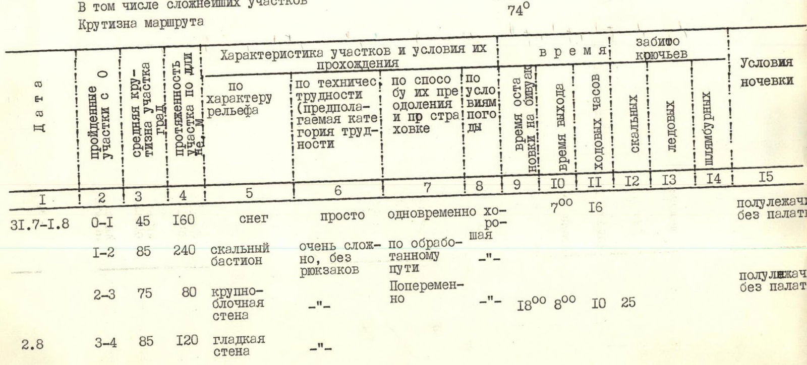
| № | Section | Relief Steepness | Section Length, m | Relief Characteristics | Technical Difficulty (assumed category of difficulty) | Method of Overcoming | Weather Conditions | Work Time, h | Departure Time | Arrival Time | Rock Pitons, pcs. | Ice Pitons, pcs. | Bolt Pitons, pcs. | Overnight Stay Conditions |
|---|---|---|---|---|---|---|---|---|---|---|---|---|---|---|
| R0–R1 | 45 | 160 | snow | simple | simultaneous | good | 7 | 00 | 16 | semi-reclined without a tent | ||||
| R1–R2 | 85 | 240 | rocky bastion | very complex, without backpacks | along the processed path | —"- | ||||||||
| 02.08 | R1–R2 | 75 | 80 | large-block wall | —"- | alternately | —"- | 18 | 00 | 8 | 00 | 10 | 25 | semi-reclined without a tent |
| R3–R4 | 85 | 120 | smooth wall | —"- | —"- | —"- | ||||||||
| R4–R5 | 95 | 40 | overhanging wall | very complex, without backpacks | alternately | good | 7 | 1 | ||||||
| 03.08 | R5–R6 | 65 | 170 | inclined tiles | complex | —"- | —"- | 17 | ||||||
| R6–R7 | 80 | 100 | monolithic wall | —"- | —"- | —"- | 20 | 00 | 8 | 12 | 10 | semi-reclined without a tent | ||
| R7–R8 | 70 | 260 | tile-like slabs | —"- | —"- | —"- | 23 | |||||||
| R8–R9 | 75 | 40 | chimney with a plug | very complex, without a backpack | —"- | —"- | 10 | 1 | ||||||
| 04.08 | R9–R10 | 70 | 260 | crumbling wall | complex | —"- | —"- | 17 | 00 | 8 | 9 | 25 | 2 | seated |
| 05.08 | R10–R11 | 60 | 120 | snowy-ice ascent | —"- | —"- | —"- | 19 | 00 | 8 | 11 | 4 | 5 | |
| R11–R12 | 55 | 140 | rocky ridge | not complex | —"- | —"- | 6 | seated | ||||||
| 06.08 | R12–R13 | 95 | 80 | large-block wall | very complex, without backpacks | alternately and via fixed ropes | —"- | 20 | 00 | 8 | 12 | 24 | 3 | seated |
| R13–R14 | 90 | 120 | solid wall | —"- | alternately | —"- | 15 | |||||||
| R14–R15 | 95 | 30 | wall chimney | —"- | —"- | —"- | 5 | seated | ||||||
| 07.08 | R15–R16 | 85 | 190 | crumbling wall | very complex, without backpacks | alternately | good | 18 | 00 | 8 | 30 | 2 | hanging | |
| 08.08 | R16–R17 | 90 | 120 | —"- | —"- | —"- | —"- | 19 | 00 | 7 | 12 | 15 | seated | |
| R17–R18 | 45 | 20 | slabs | simple | simultaneously | —"- | 20 | 00 | 6 | 14 | hanging | |||
| 09.08 | R18–R19 | 70 | 280 | icy, crumbling rocks | very complex | alternately in crampons | —"- | 28 | 4 | tent on the summit | ||||
| 10.08 | R19–R20 | 65 | 110 | icy couloir | complex | alternately in crampons | —"- | 7 | ||||||
| R20–R21 | 85 | 140 | rocky tower | very complex | alternately | —"- | 15 | 00 | 6 | 9 | 24 | 2 |
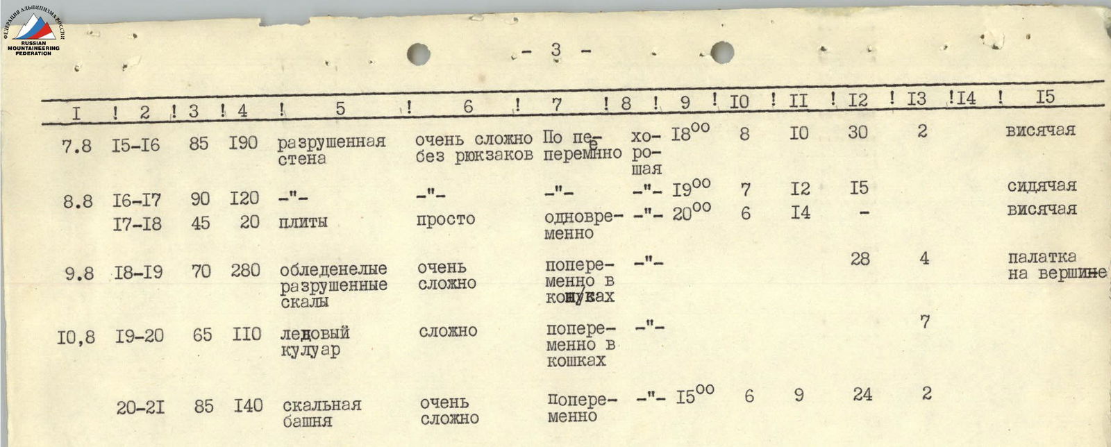
Descent along the northern snowy-icy ridge approximately 3B-4A category of difficulty on August 11-12.
Total driven:
- rock pitons - 294
- ice - 30
For the passage of the route, 203 hooks were used; for organization, pulling up backpacks, bivouacs, etc. - 108
Team Captain and Coach B. Sivtsov
The waterfall is working!
