ON THE FIRST ASCENT OF THE SOUTH COUNTERFORCE OF THE WESTERN RIDGE OF PIK A. GRIN BY A GROUP OF CLIMBERS FROM THE KUYBYSHEV REGIONAL COUNCIL OF THE “TRUD” SPORTS SOCIETY July 28–31, 1976
I. Introduction
Pik A. Grin (6525 m) is located in the upper reaches of the Fedchenko Glacier. Widespread mountaineering exploration of this area began in 1957 when participants of the “Burevestnik” Sports Society expedition, led by E. Tamm, made the first ascents of:
- Pik 26 Komissarov (6834 m), led by E. Tamm,
- Pik Parizhskoy Kommuny (6300 m), led by V. Benkin.
The first ascent of Pik A. Grin was made under the leadership of V. Serebryakov in 1960 via the western ridge. Subsequently, this area was repeatedly visited by mountaineering expeditions.
The most significant sporting achievements were made by expeditions led by L. Myshlyaev — the ascent of the north face of Pik Revolyutsii in 1961, and the traverse from Pik Parizhskoy Kommuny to Pik Grin, led by V. Ryazanov in 1964.
In 1976, an expedition from the Kuybyshev Regional Council of the “Trud” Sports Society ascended to the upper cirque of the Fedchenko Glacier, with the following objectives:
- First ascent of the western wall of Pik A. Grin, counting towards the USSR Alpine Championship.
- Ascent of Pik 26 Komissarov via the western ridge, counting towards the “Trud” Sports Society Central Council Alpine Championship.
As a training ascent before the planned ascent of Pik 26 Komissarov, a group consisting of: Blokhin A.V. — leader, Benkin V.S., Yastrebov V.G., Ovsyannikov Yu., Anisimov V., and Ovsyannikov B. made the first ascent of the south counterforce of the western ridge of Pik A. Grin.
II. Data on the Ascent Participants
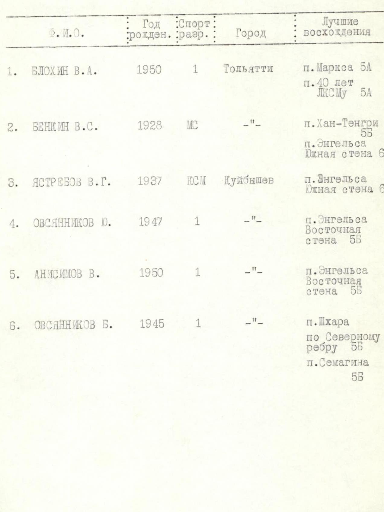
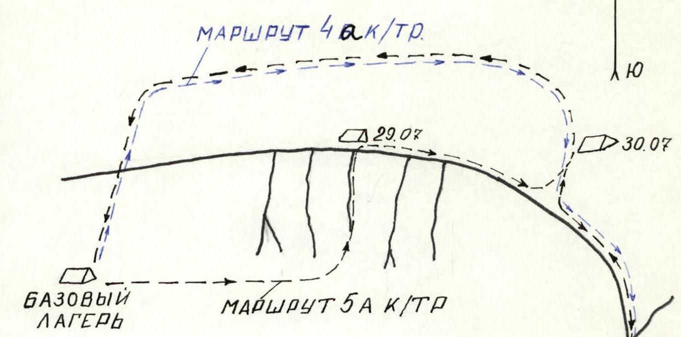
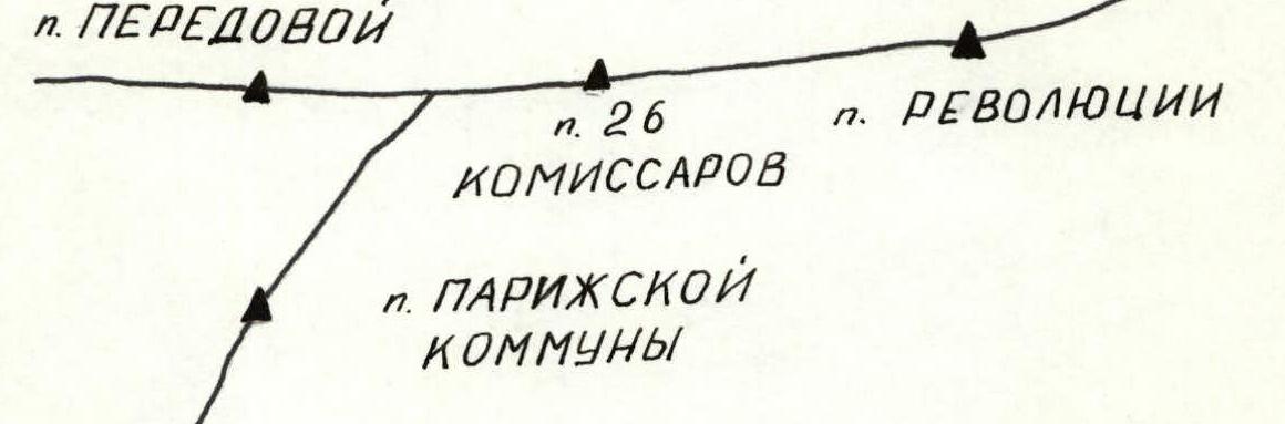
Table of Data on the Ascent Participants
| Name | Year of Birth | Sport Rank | City | Notable Ascents |
|---|---|---|---|---|
| Blokhin V. A. | 1950 | 1st Sports Category | Tolyatti | Pik Marxa 5A, Pik 40 let LKSMU 6A |
| Benkin V. S. | 1928 | Master of Sports | —"— | Pik Khan-Tengri 5B, Pik Engel'sa South Face 6 |
| Yastrebov V. G. | 1937 | Candidate Master of Sports | Kuybyshev | Pik Engel'sa South Face 6 |
| Ovsyannikov Yu. | 1947 | 1st Sports Category | —"— | Pik Engel'sa East Face 5B |
| Anisimov V. | 1950 | 1st Sports Category | —"— | Pik Engel'sa East Face 5B |
| Ovsyannikov B. | 1945 | 1st Sports Category | —"— | Pik Shkhara North Ridge 5B, Pik Semagina 5B |
MAP-SCHEME OF THE ASCENT AREA

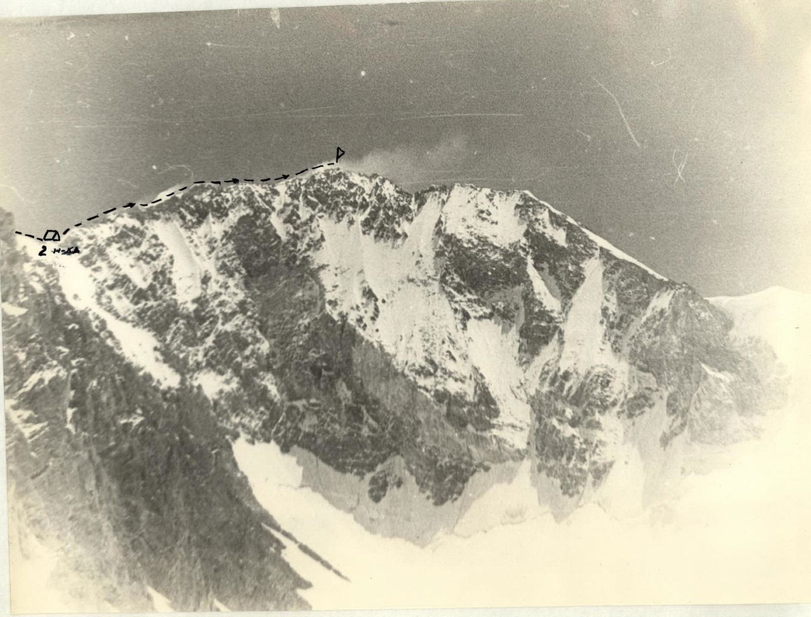
III. Route Description
July 28. The group left the base camp (5200 m) at 9:00 to recon the route and reached the base of the route at 10:00. Elevation 5300 m.
After examining the route, it became clear that reaching the ridge in one day was unlikely without prior route preparation. Considering:
- the lack of suitable bivouac sites before reaching the ridge,
- the possibility of cutting steps in the firn slope at this time of day,
the group decided to prepare the initial section.
Section R0–R1 — ice slope, up to 40° steep, approximately 400 m long, covered with firn snow 10–40 cm deep. Movement is simultaneous, becoming alternating in the upper part, with ice axe belays. By 14:00, they reached the start of the counterforce and began descending. By 16:00, they returned to camp.
July 29. They departed from the base camp at 6:00, reached the prepared section, and followed their tracks to the start of the counterforce by 9:00.
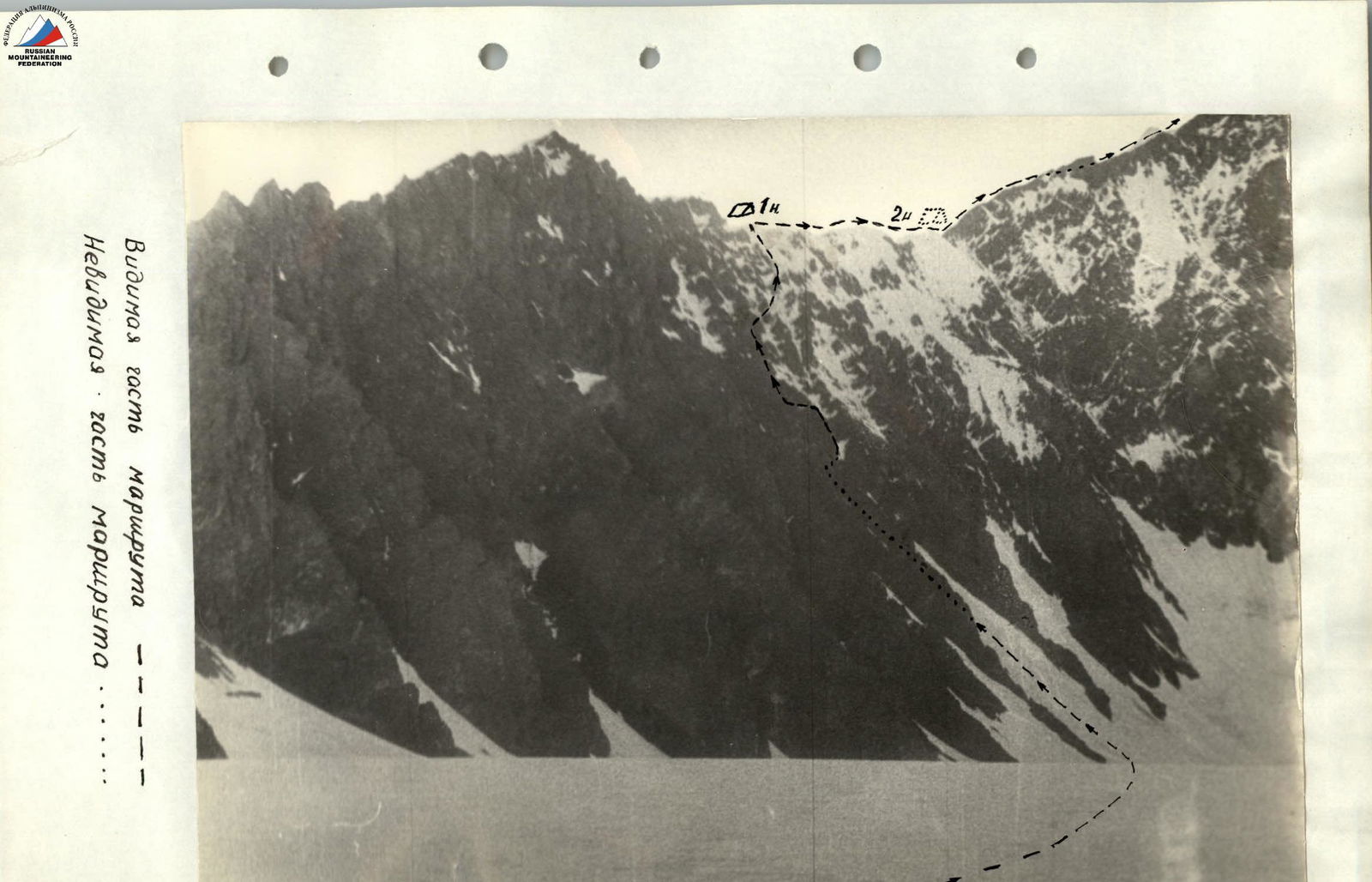
Section R1–R2. They ascended along the counterforce, left of its crest. The rocks are heavily deteriorated, with a 45° slope. Movement is simultaneous, with belays using rock outcrops. The section is 200 m long.
Section R2–R3 starts with significant glaciation due to the rise of lateral ice couloirs onto the counterforce. The slope is 35°, and the section is 100 m long. Movement is alternating, with belays using ice and rock anchors. In some places, they cut steps.
Section R3–R4: They approached a rock wall, 80° steep, 40–50 m high. Considering the high danger of ascending the heavily deteriorated wall, they bypassed it on the right, following an ice slope at 45°.
Movement:
- Alternating
- The lead climber cuts steps
- Belays using ice anchors
The section is 150 m long.
Section R4–R5: Along a rock slope, 60° steep, 60 m long. They reached the counterforce.
The rocks are heavily deteriorated, with many loose stones on small ledges. There are many cracks, but few are suitable for anchor placement. Climbing is very challenging. Movement is alternating, with anchor belays.
Section R5–R6. Movement along the counterforce is at 45°, with heavily deteriorated rocks, making climbing difficult. From this section, it was visible that the exit to the western ridge is complicated by a serac in the upper part of the counterforce. Considering the danger of moving along heavily deteriorated rocks and the risk of seracs, they decided to transition from the counterforce to the ice-snow ridge. To do this, they had to cross an ice couloir with a rock outcrop in the middle.
Section R6–R7
- Crossing an ice couloir, 40–45° steep, 40 m wide
- The lead climber cuts steps
Caution! Danger of seracs from the western ridge. They approached the wall. Movement in the couloir is alternating, with anchor belays.
Section R7–R8
- Wall, 80° steep, 20 m high
- Rocks are heavily deteriorated
- Many loose stones on outcrops, covered with snow
- Climbing is very challenging
- Movement is alternating
- Anchor belays
Section R8–R9 — snow-ice ridge, 30° steep, 200 m long. The snow is dry and loose, with depths exceeding 1 m in places. They had to dig a trench. Passing this section required significant physical effort. Belays are alternating, using ice axes. They reached the main western ridge along the ridge. Time: 17:00. They set up a bivouac, cutting a platform in the firn. Elevation 5900 m. They built a cairn and left a note. The weather began to deteriorate.
July 30. They departed from the bivouac at 9:00. The weather worsened. Strong wind, occasional snow, fog, visibility 100–200 m. Considering that the further route should be technically straightforward, they decided to continue the ascent.
Section R9–R10. Snow-ice ridge, average steepness 20°, with some steeper sections up to 35°. The section is 1000 m long. Movement is mostly simultaneous, becoming alternating on steeper sections and where the firn is thin, with ice axe belays.
The ridge led to a snow slope, 20° steep. Due to bad weather, they deviated left 200 m, to the start of the descent to the glacier, and set up a bivouac under a rock wall about 10 m high. Elevation 6300 m.
July 31. The weather is bad, windy, foggy, with occasional snow. They departed at 9:00. They ascended the snow slope and reached the Western Ridge.
Section R10–R11. Snow-ice ridge, average steepness 15°, 700 m long. Movement is simultaneous.
By 13:00, they reached the summit. Bad weather prevented them from finding the cairn. They built a cairn and left a note.
The group's movement from the second bivouac site followed the already classified route of category 4B difficulty.
At 13:30, they began descending from the summit and returned to the base camp by 20:00.
IV. Conclusion
The group completed a new, sufficiently challenging and physically demanding route in 20 hours of climbing. The elevation gain:
- to the western ridge was 600 m.
- to the summit along the western ridge was 600 m.
43 rock and 19 ice anchors were placed on the route.
The main difference between this route and the previously climbed route is the ascent to the western ridge via the south counterforce. This part of the route is technically much more challenging than the western ridge.
The western ridge is mostly traversed simultaneously. In good weather, it is possible to complete this section in one day.
The ascent via the counterforce requires a high level of individual climbing skill, as the heavily deteriorated rocks pose an objective danger to the climbers. Passing the rock sections demands constant attention and caution.
Considering the technical difficulty, elevation, and harsh climatic conditions of the ascent area, the group believes that the route corresponds to category 5A difficulty.
Ascent leader: Blokhin V.