Ascent Log
-
Ascent category — technical
-
Pamir, Yazgulyam Range
-
Peak 5200 m via the center of the northwest wall
-
Estimated difficulty — 5B cat. (first ascent)
-
Ascent description (route):
Height difference — 1200 m Length of sections with 5th cat. difficulty — 448 m, 6th cat. difficulty — 165 m Average steepness 64°
-
Pitons used: for belaying: rock — 144 (including protection gear), bolt — 6, ice — 4; for creating artificial anchors: rock — 4
-
Total climbing hours — 43
-
Number of bivouacs — 3 (1st lying, on a comfortable ledge; 2nd sitting, on an uncomfortable ledge with the use of hammocks; 3rd lying, on a comfortable platform)
-
Team members:
- KRASAVIN VIKTOR IVANOVICH, Candidate Master of Sports, team leader
- SHEMENEV ALEKSANDR GRIGOR'EVICH, Candidate Master of Sports, deputy team leader
- SALAZKO MIKHAIL NIKOLAEVICH, Candidate Master of Sports
- SOKOLOV VIKTOR MIKHAILOVICH, Candidate Master of Sports
-
Team coach: Master of Sports of the USSR, 1st category instructor-methodologist MAN'SHIN YURI PAVLOVICH
-
Date of team's departure for the route — July 17, 1982, date of return — July 20, 1982
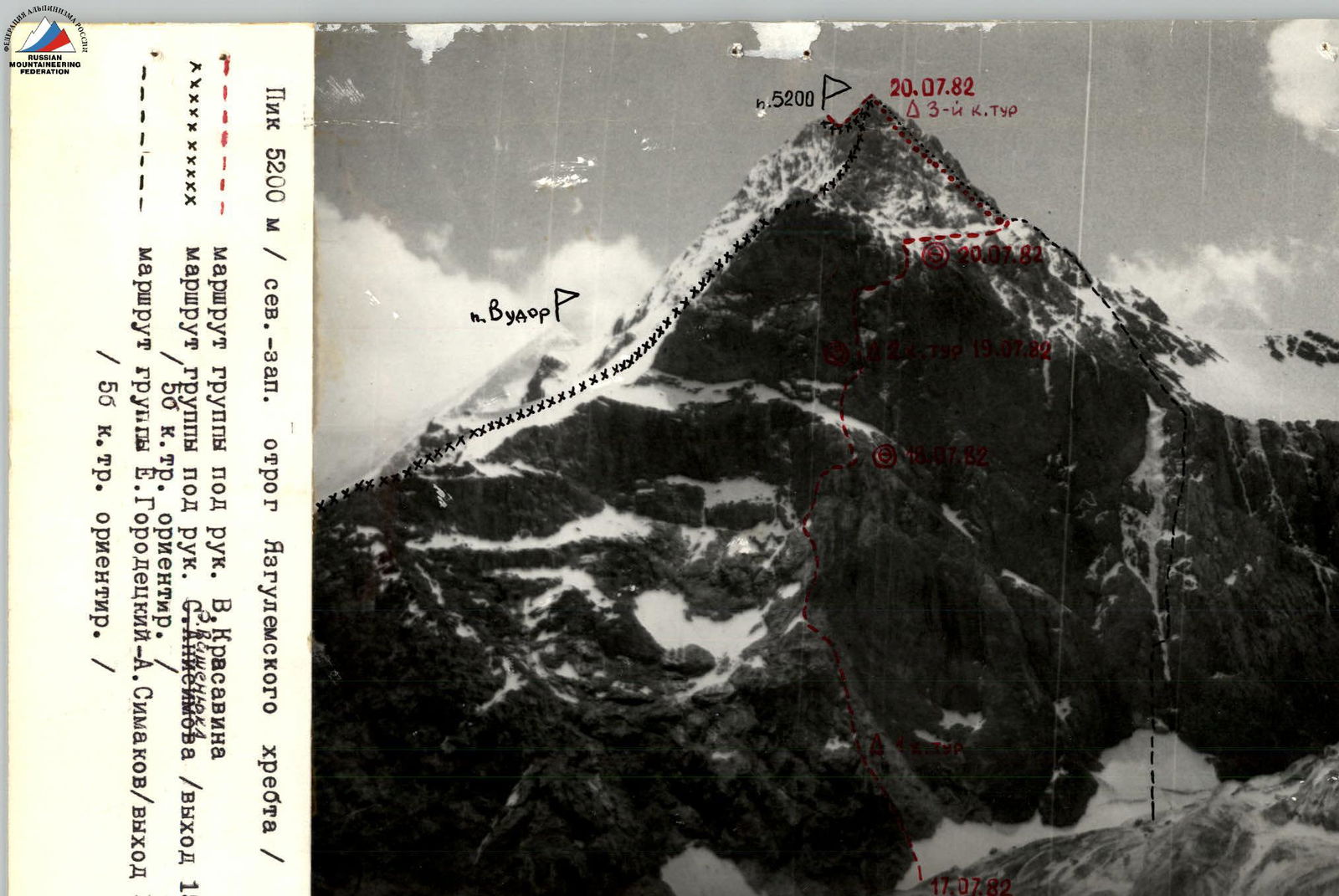
Peak 5200 m (NW spur of the Yazgulyam Range)
 Route of the group led by V. Krasavin
Route of the group led by S. Annenkov (departure July 15, 1982) / 50 cat. appr. /
Route of the group B. Gorodetsky—A. Simakov (departure July 16, 1982) / 5B cat. appr. /
Route of the group led by V. Krasavin
Route of the group led by S. Annenkov (departure July 15, 1982) / 50 cat. appr. /
Route of the group B. Gorodetsky—A. Simakov (departure July 16, 1982) / 5B cat. appr. /
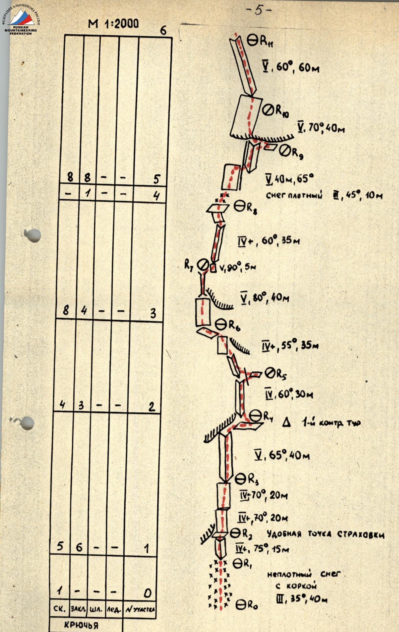
Route diagram to Peak 5200 m via the center of the NW wall, 5B cat. (first ascent)
In UIAA symbols.
| Rock | Chocks | Bolt | Ice | Section # |
|---|---|---|---|---|
| 8 | 8 | - | - | 5 |
| - | 1 | - | - | 4 |
| 8 | 4 | - | - | 3 |
| 4 | 3 | - | - | 2 |
| 5 | 6 | - | - | 1 |
| 1 | - | - | - | 0 |
PITONS
Sections R0–R11:
- R11: V, 60°, 60 m
- R10: V, 70°, 40 m
- R9: V, 40 m, 65°. Dense snow IV, 45°, 10 m
- R8: IV+, 60°, 35 m
- R7: V, 90°, 5 m
- R6: V, 80°, 40 m
- R5: IV+, 55°, 35 m
- R4: V, 60°, 30 m
- R3: IV, 65°, 40 m. Δ 1–4 control cairn
- R2: IV, 70°, 20 m
- R1: IV+, 70°, 20 m. Comfortable belay point. IV+, 75°, 15 m.
- R0: III, 35°, 40 m. Loose snow with crust.
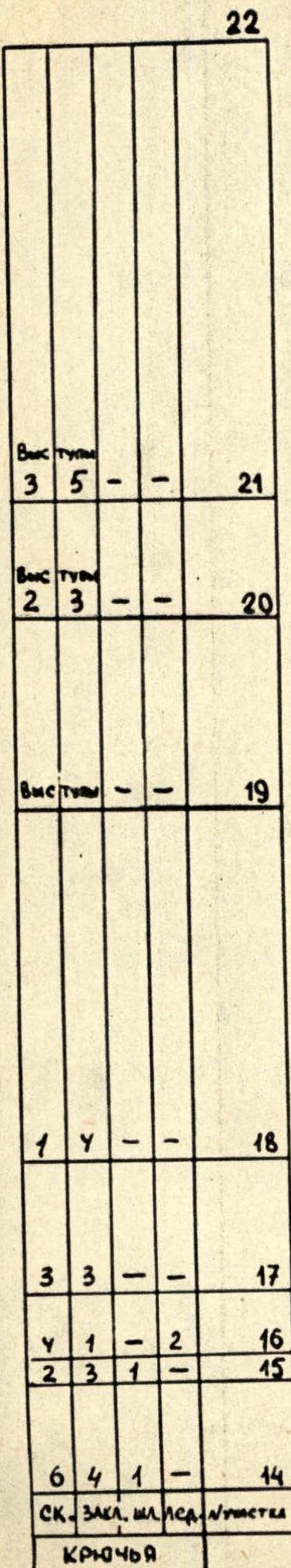
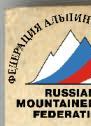
| Rock | Chocks | Bolt | Ice | Section # |
|---|---|---|---|---|
| 5 | 6 | 2 | - | 13 |
| 2 | 1 | - | - | 12 |
| 5 | 4 | 1 | - | 11 |
| 2 | 4 | - | - | 10 |
| 1 | - | - | 2 | 9 |
| 2 | 3 | - | - | 8 |
| 2 | 2 | - | - | 7 |
| 9 | 3 | 1 | - | 6 |
PITONS
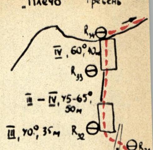
Sections R12–R22:
- R22: V, 80°, 20 m. Pendulum right 6 m (need to get to the lower part of the slab!)
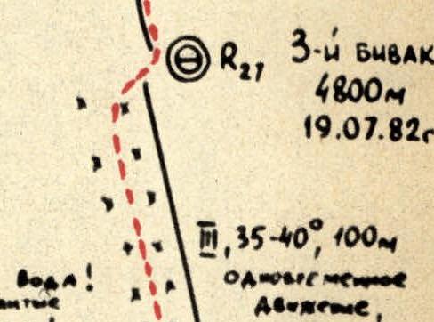
- R21: V, 85°, 35 m. Excellent slab with solid microridges, free climbing in crampons. (Limited belay options — monolithic rocks)
- R20: V, 70°, 25 m
- R19: V, A3, 100°, 15 m. Ice in the chimney. V, 70°, 25 m.
- R18: IV, A3, 100°, 15 m. Ice in the chimney. V, 70°, 35 m.
- R17: IV, 45°, 40 m
- R16: IV, 60°, 60 m
- R15: IV, 20°, 35 m
- R14: V, 70°, 20 m
- R13: V, A1/e, 90°, 12 m. V+, 80°, 20 m.
- R12: II, 10°, 20 m. Traverse.
1st bivouac: 4400 m. July 17, 1982. 2nd bivouac: 4600 m. July 18, 1982.


| Rock | Chocks | Bolt | Ice | Section # |
|---|---|---|---|---|
| 3 | 5 | - | - | 21 |
| 2 | 3 | - | - | 20 |
| - | - | - | - | 19 |
| 1 | 4 | - | - | 18 |
| 3 | 3 | - | - | 17 |
| 4 | 1 | - | 2 | 16 |
| 2 | 3 | 1 | - | 15 |
| 6 | 4 | 1 | - | 14 |
PITONS
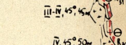
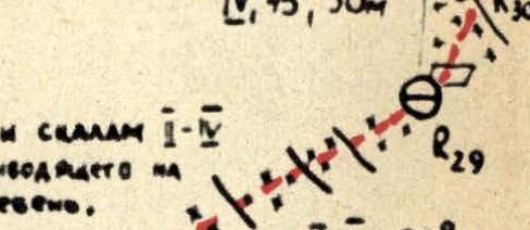
Sections R23–R33:
- R33: IV, 60°, 82 m
- R32: III–IV, 75–65°, 50 m
- R31: IV, 70°, 35 m
- R30: III–IV, 45°, 45 m
- R29: IV, 45°, 50 m
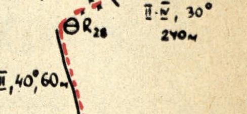
- R28: III, 30°, 240 m. On dense snow and rocks II–IV to the right to a couloir leading to the pre-summit ridge. IV, 40°, 60 m.
- R27: V, 40°, 30 m. Wall steepness 65–70°! Icicles hanging from cornices. Totally cracked rocks covered with a thick layer of ice!
- R26: III, 35–40°, 100 m. Simultaneous movement, belay on a rock ridge. V, 0°, 40 m. Loose coarse-grained snow (15 m) not connected to the underlying ice 60°. V, 70°, 40 m.
- R25: Huge cornices! (10–15 m). IV, 90°, 8 m.
- R24: V, A4/e, 85–90°, 40 m. Key point of the route! Difficult slab, crampons, 1 ladder.
- R23: (Text refers to R24)
3rd bivouac: 4800 m. July 19, 1982.
| Rock | Chocks | Bolt | Ice | Section # |
|---|---|---|---|---|
| 3 | 3 | - | - | 22 |
| - | - | - | - | 23 |
PITONS
Sections R34–R40:
- R40: V, 70°, 45 m. (To Peak 5200 m) July 20, 1982.
- R39: V, 65°, 40 m. Narrow ridge.
- R38: IV, 20 m, 70°. IV, 5 m! 90°, V! V, 50°, 15 m.
- R37: IV, 45–60°, 40 m.
- R35: 3rd control cairn
- R34: II, 30°, 35 m.

Table of the main characteristics of the ascent route to Peak 5200 m via the center of the NW wall, 5B cat. (first ascent). Pamir, Yazgulyam Range
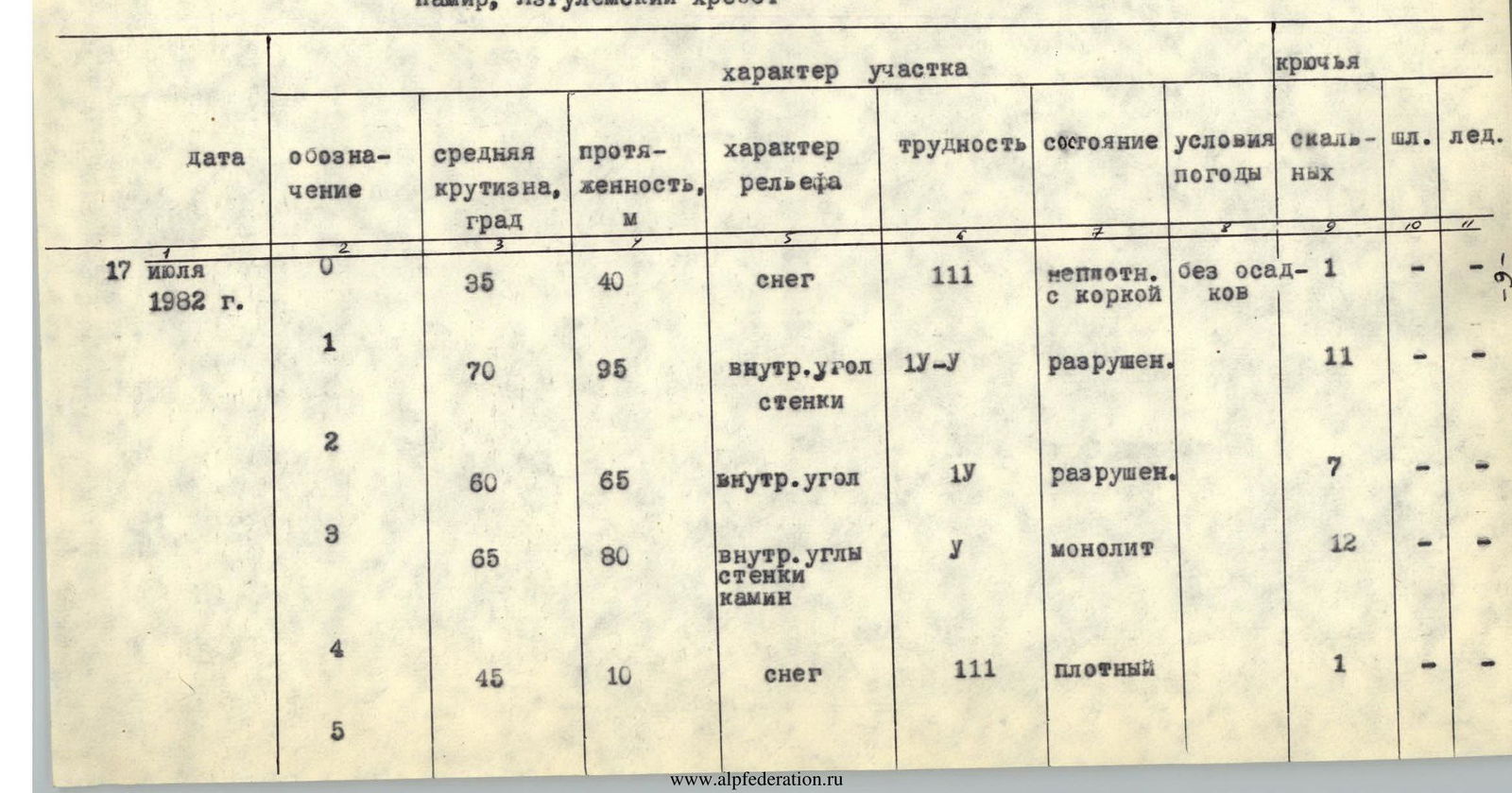
| Date | Section # | Average steepness, deg | Length, m | Terrain characteristics | Difficulty | Condition | Weather | Rock pitons | Bolt | Ice |
|---|---|---|---|---|---|---|---|---|---|---|
| July 17, 1982 | 0 | 35 | 40 | snow | III | loose with crust | no precip | 1 | - | - |
| 1 | 70 | 95 | inner corner, walls | IV–V | destroyed | 11 | - | - | ||
| 2 | 60 | 65 | inner corner | IV | destroyed | 7 | - | - | ||
| 3 | 65 | 80 | inner corners, walls, chimney | V | monolith | 12 | - | - | ||
| 4 | 45 | 10 | snow | III | dense | 1 | - | - | ||
| 5 | 65 | 140 | slabs, inner corner | V | slabs-monolith, inner corner destroyed | no precip | 16 | - | - | |
| 6 | 80 | 50 | walls, ledges | V, V+, V1 | destroyed | 11,1 | 1 | - | ||
| 7 | 0–20 | 30 | ledge, walls | III–IV | destroyed | 4 | - | - |
Departure time – 7:00, stop for bivouac – 20:30. 13 climbing hours. Bivouac lying, comfortable. Elevation: start of the route – 4000 m, bivouac – 4400 m.
| Date | Section # | Average steepness, deg | Length, m | Terrain characteristics | Difficulty | Condition | Weather | Rock pitons | Bolt | Ice |
|---|---|---|---|---|---|---|---|---|---|---|
| July 18, 1982 | 8 | 60 | 60 | walls, ledges | IV | destroyed | no precip | 5 | - | - |
| 9 | 45 | 40 | snow, ice | III | dense | 1 | - | 2 | ||
| 10 | 70 | 35 | wall | V | destroyed | 6 | - | - | ||
| 11 | 85 | 55 | chimneys, slab | V–V | chimneys-destroyed, slabs-monolith | no precip | 6,111 | 1 | - | |
| 12 | 70 | 25 | slab | V | monolith | 3 | - | - |
Departure time – 8:00, stop for bivouac – 20:00. 12 climbing hours. Bivouac uncomfortable, sitting, with the use of hammocks. Elevation of the bivouac – 4600 m.
| Date | Section # | Average steepness, deg | Length, m | Terrain characteristics | Difficulty | Condition | Weather | Rock pitons | Bolt | Ice |
|---|---|---|---|---|---|---|---|---|---|---|
| July 19, 1982 | 14 | 85 | 55 | slab, inner corner | V1 | monolith | no precip | 11 | 2 | - |
| 15 | 85–90 | 40 | slab | V1 | monolith | 10 | 1 | - | ||
| 16 | 60 traverse | 40 | snow-covered slab | V | loose, not connected to the underlying rocks and ice | 5 | 1 | - | ||
| 60 traverse | 40 of which 8 m – chimney | slabs, chimney | V1, V | rocks covered with ice destroyed | 5 | - | 2 | |||
| 17 | 70 | 40 | walls | IV | destroyed | no precip | 6 | - | - | |
| 18 | 40 | 100 | snow | III | loose, wet | 5 | - | - |
Departure time – 8:00, stop for bivouac – 19:30. 11.5 climbing hours. Bivouac comfortable, lying. Elevation of the bivouac – 4800 m.
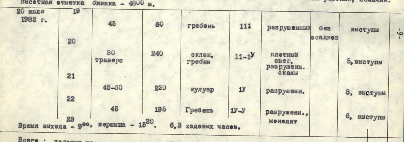
| Date | Section # | Average steepness, deg | Length, m | Terrain characteristics | Difficulty | Condition | Weather | Rock pitons | Bolt | Ice |
|---|---|---|---|---|---|---|---|---|---|---|
| July 20, 1982 | 19 | 45 | 60 | ridge | III | destroyed | no precip | ledges | ||
| 20 | 30 traverse | 240 | slope, ridges | III–IV | dense snow, destroyed rocks | 5, ledges | ||||
| 21 | 45–60 | 220 | couloir | IV | destroyed | 8, ledges | ||||
| 22 | 45 | 195 | ridge | IV–V | destroyed, monolith | 6, ledges |
Departure time – 9:00, summit – 15:20. 6.3 climbing hours. Total: climbing hours on the route – 42.8. Total: 144 rock, 6 bolt, 4 ice.
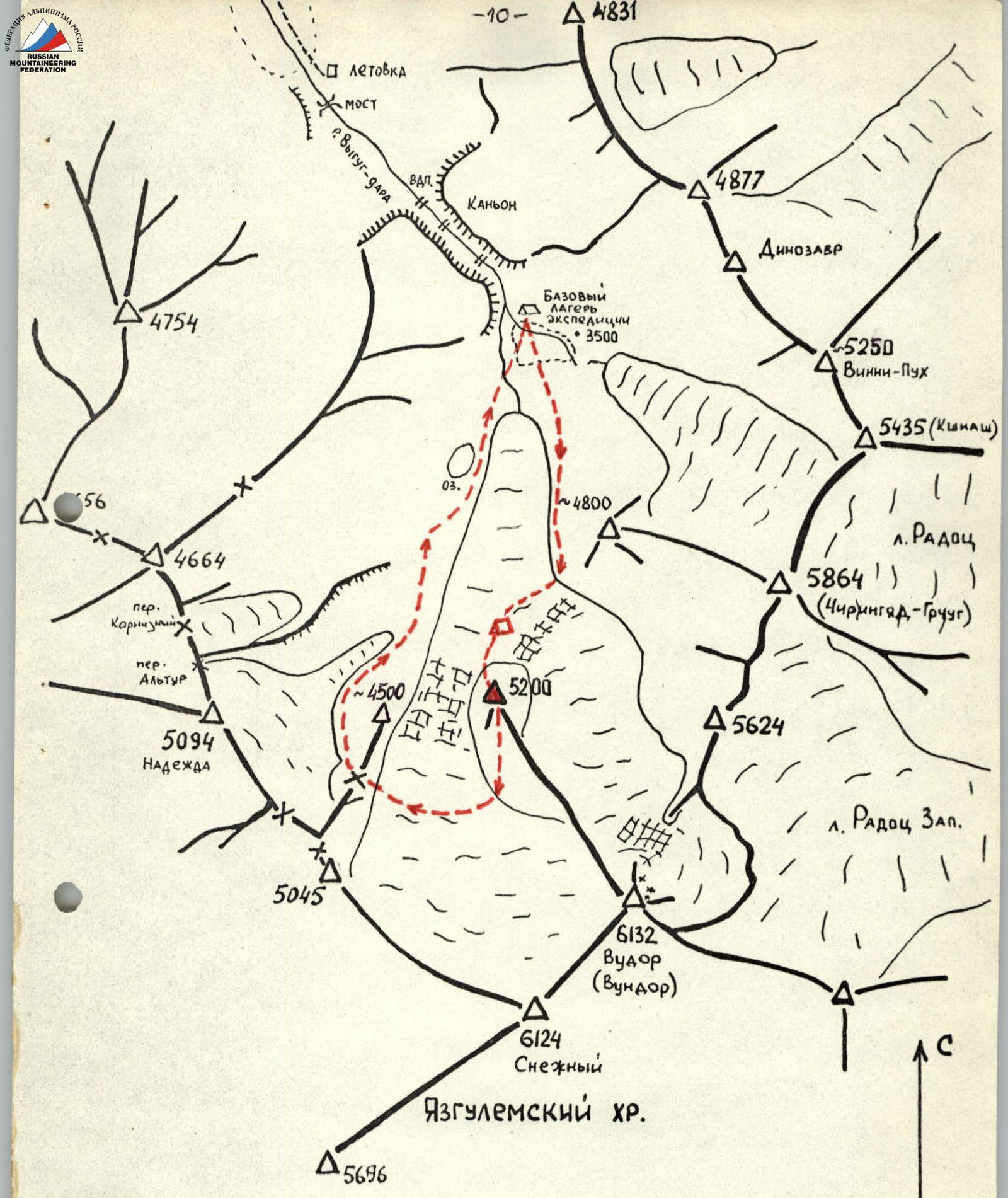
Map Diagram
WESTERN PART OF THE YAZGULYAM RANGE (Vudor, Chiringyad – local names of mountains in the Yazgulyam language) Scale 1:50000
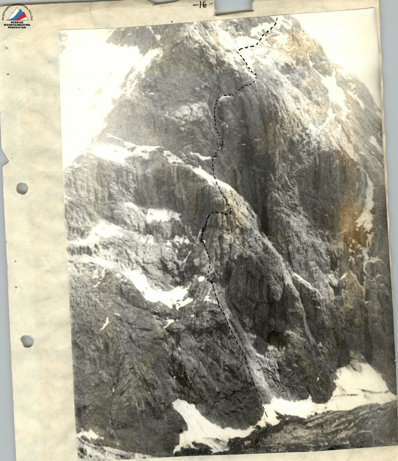
Photo 7. NW wall of Peak 5200 m