I. Passport
- Climbing category — technical.
- Climbing area — Central Pamir, Yazgulemsky Ridge, Vychuk-Dara valley.
- Peak — "5200" peak via the right part of the NW wall, first ascent.
- Difficulty category — proposed 5B.
- Route characteristics:
- total length — 1360 m;
- height difference — 1200 m;
- average steepness — 62°;
- length of sections with 5th and 6th difficulty categories — 666 m; including 6th category — 82 m;
- length of the wall section — 340 m;
- wall height difference — 320 m;
- average wall steepness — 70°.
- Pitons driven:
| For belaying | For creating belay stations |
|---|---|
| Rock | 88/3 |
| Bolt | 2 |
| Nuts | 60 |
| Ice | 1 |
- Duration — 25 hours, 3 days.
- Number and characteristics of bivouacs — 2; 1st — sitting on a ledge, 2nd in a tent on a scree platform.
- Leader — Simakov A.N., Candidate Master of Sports; participant — Gorodetsky E.M., Master of Sports.
- Team coach — Gorodetsky E.M.
- Dates of starting the route and returning to base camp:
- departure 16 July 1982,
- summit 18 July 1982,
- return 15 July 1982.
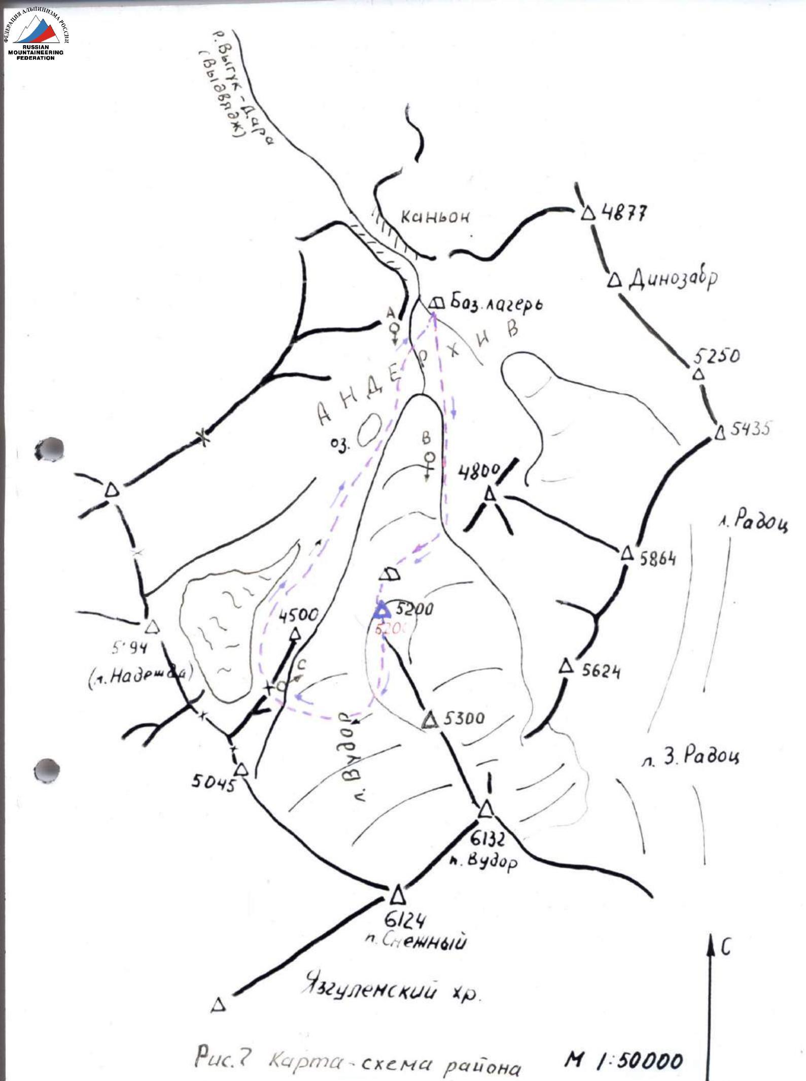
Fig. 2. Area map, scale 1:50000. Fig. 3. Lower part of the route (19 July 1982, 16:30. Compur F=75 mm L=150 m; h=4000 m. Photo taken from under the route. www.alp-federation.ru
25 24
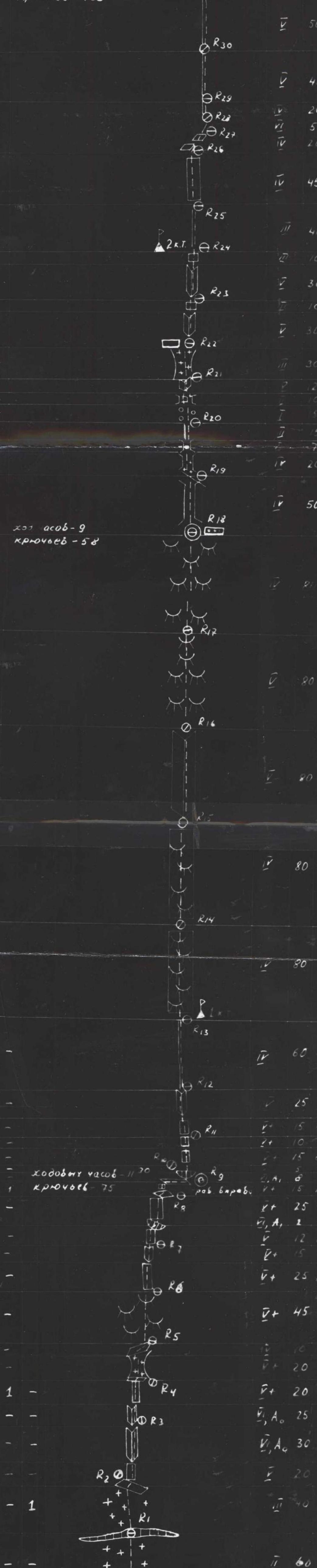
 Brief explanation of the route diagram (Fig. 6)
Sections 0–I — snow-ice slope.
Sections 2–5: monolithic rocks of extreme difficulty, smooth and strong, but with sufficient cracks for pitons and nuts.
Section 6: sheer section of a gully, with iced snow of scaly structure and ice crust.
Sections 7–29:
Brief explanation of the route diagram (Fig. 6)
Sections 0–I — snow-ice slope.
Sections 2–5: monolithic rocks of extreme difficulty, smooth and strong, but with sufficient cracks for pitons and nuts.
Section 6: sheer section of a gully, with iced snow of scaly structure and ice crust.
Sections 7–29:
- Steep, smooth, and heavily degraded rocks with few cracks for reliable belays;
- Movement on a double rope with a shock absorber;
- Rocks are partially snow-covered and iced;
- Characterized by large-block relief with an unstable surface. Sections 22–26: Rocks resembling "sheep's foreheads" with weathered, eroded surface. Virtually no cracks, but micro-relief allows for relatively safe movement, mainly using friction and surface depressions. Sections 27–46:
- Fairly strong rocks with few cracks;
- Rich relief: walls, chimneys, ridges;
- Partially, especially on sections 41–46, heavily snow-covered.
Descent: via the ascent route to section 27, then left, following scree ledges and a snowy couloir to the Vudor glacier.
Brief characteristics of the climbing area
Peak 5200 is located in the western part of the Yazgulemsky Ridge, in a short northwest spur extending from Peak Vudor into the Anderkhiv and Vyguk-Dara (Vydvyadzh) valleys. The area is characterized by low visitation and unexplored nature in terms of mountaineering. The only ascent in the area was made by the Lavrukhin group on Peak Vudor from the southeast during the traverse of Peaks Pamyati Vosmi — Vudor in 1977. Other peaks in the area remained unconquered. In 1979, a group of Moscow tourists led by V. Nesterov first penetrated the upper Vyguk-Dara (Vydvyadzh) valley. The area's inaccessibility is due to its remote location from the Yazgulem-Dara valley. The upper part of the Vyguk-Dara valley is terminated by a rocky step with a sheer wall 160–180 m high and a narrow, impassable canyon. Above the step lies the upper Anderkhiv cirque, accessible:
- by helicopter;
- via a lateral pass 4700 in the left orographic part of the valley. In July–August 1982, an expedition by the CS DSO "Lokomotiv" worked in the valley, making ascents to the peaks:
- 5094
- 4877
- 5250
- 5864
- 6562
- 4 One of the ascent targets was Peak 5200. On 17 July 1953, a group led by E. Vashenyuk made the first ascent to the summit. The ascent described in this report was the second ascent. Later, groups led by:
- V. Krasavin
- V. Ponomarchuk ascended via the center of the NW wall. The area is characterized by large wall height differences and high steepness. Glaciation is quite significant. Summer weather is generally stable. A notable feature is the great diversity of rock types forming the relief:
- hard vitreous rocks
- friable schist
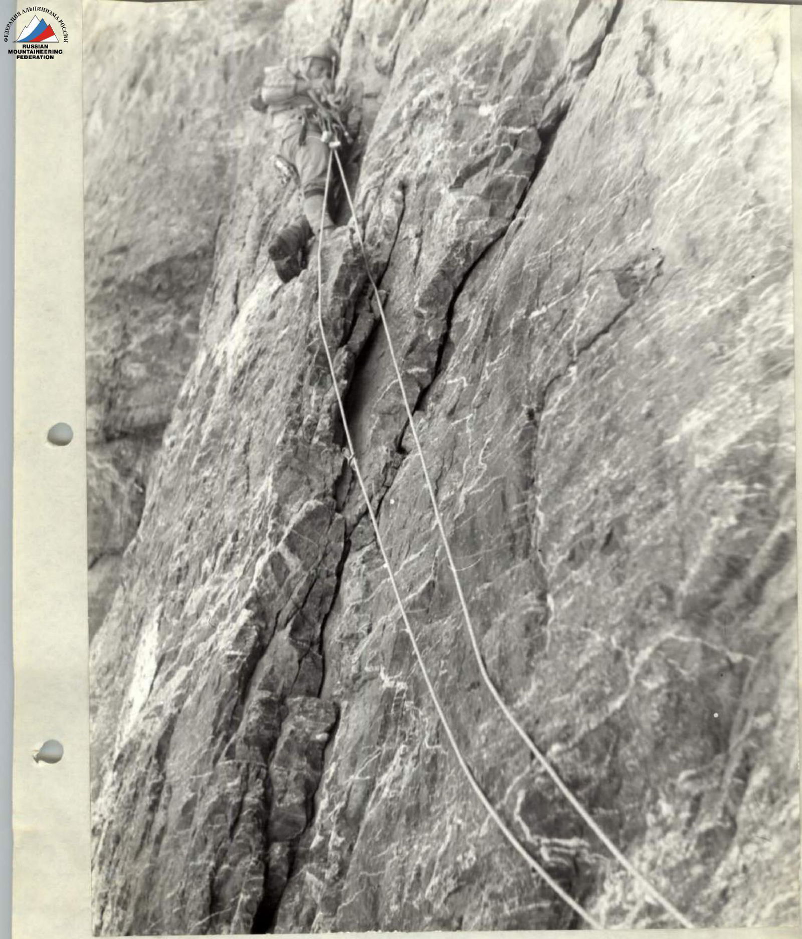
Fig. 10. Passing section 3 (point 1). 16 July 1982. Compur F=75 mm L=10–12 m
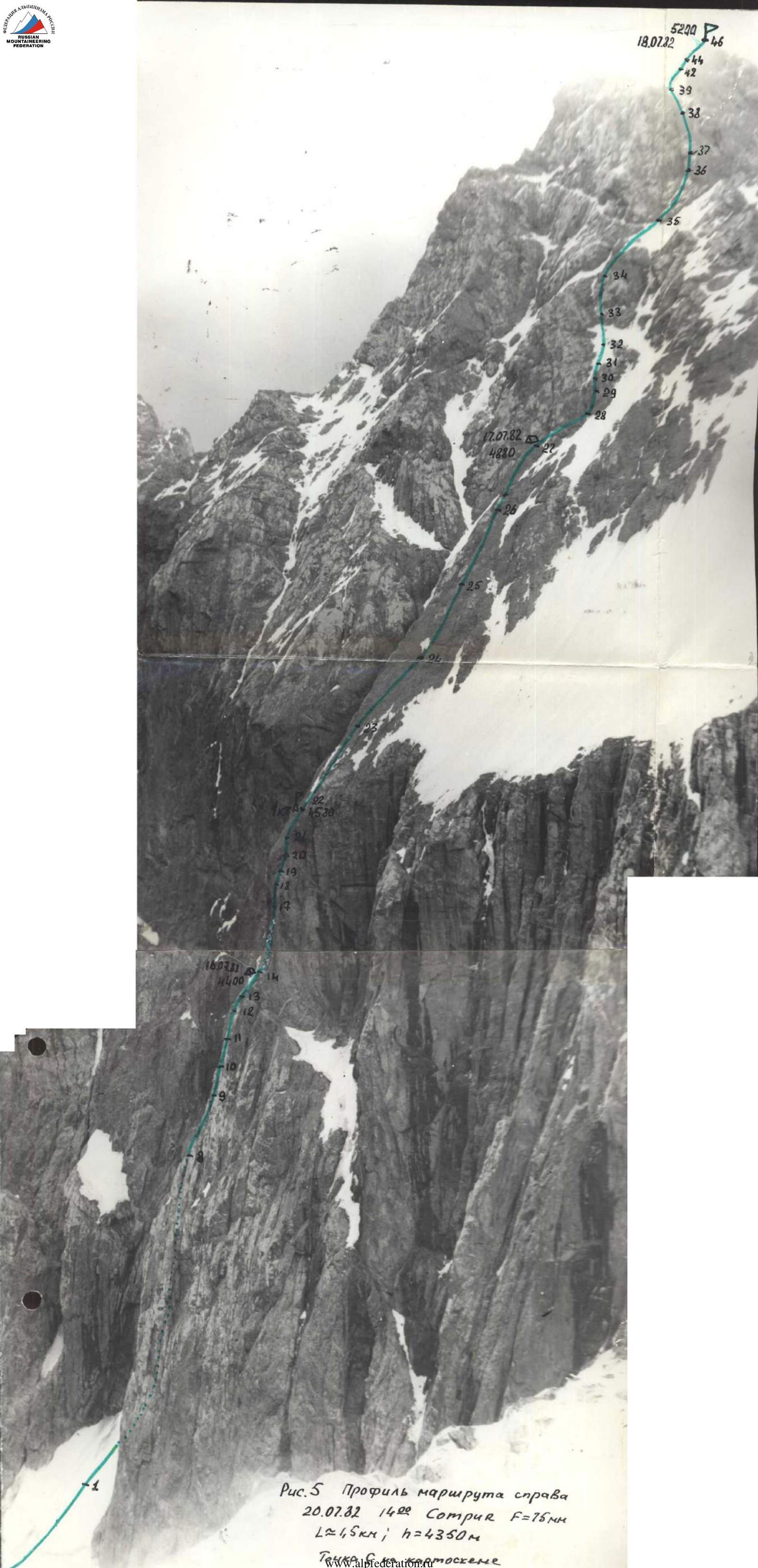
Fig. 5. Route profile from the right. 20 July 1982, 14:00. Compur F=75 mm; L≈1.5 km; h=4350 m.