APPENDIX №2 Description of the first ascent route to Peak Vasiliev D. (G. Yazovskikh, 1967)
Pamir. Upper reaches of the Fedchenko Glacier. Description of the first ascent to Peak D. E. Vasiliev (6100 m). 4A category of difficulty via a combined route from the south. The first ascent was made by a group from the expedition of the Chelyabinsk Regional Council of the "Trud" Sports Society on August 19, 1967.
Leader: G. Yazovskikh.
The description was compiled by:
- G. Yazovskikh
- B. K. Potapkin
- K. P. Veselov
Chelyabinsk Regional Alpine Federation. 1967.
Contents
- Introduction.
- General characteristics of the route.
- Technical description.
- Recommendations for the route.
- Group composition.
- Proposal for naming the peak.
- Proposal for route assessment.
- Table of main characteristics.
- Route profile.
- Map-scheme of the area.
- Photographs.
Introduction
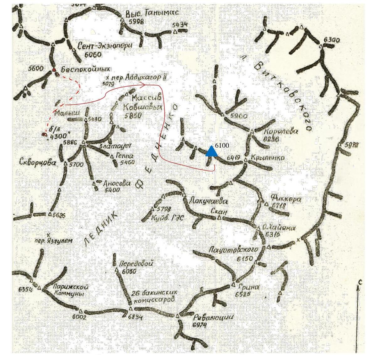
The 6100 m peak is located in the western spur of the main ridge of the southern group of Fedchenko mountains. This spur starts from Peak Krylenko (6419 m) and divides two small glaciers — Sredny and Snezhný, which flow into the Fedchenko Glacier. To the south of Peak Krylenko stands Peak Fickler (6718 m). There are three distinct unnamed peaks in the spur. The one closest to Peak Krylenko is the highest — 6100 m.
From the Abdukagor II pass, we descend to the Fedchenko Glacier and, following its middle part, move upwards towards Peak 26 Baku Commissars. We pass the Sredny Glacier, adjacent to the Vítkovsky Glacier, and, crossing the Fedchenko Glacier, head towards the second glacier, "Snezhný", from the Vítkovsky Glacier.
The journey from the Abdukagor II pass to the "Snezhný" Glacier took 3 hours.
The path to the start of the route goes along the gentle, closed "Snezhný" Glacier, above the cirque of which the majestic Peak Fickler rises. In its upper reaches, the glacier is divided into two parts by the western ridge of Peak Fickler. We set up a base camp in the northern branch of the glacier, at an approximate height of 5800 m. From the camp, almost the entire ascent route is visible.
The 6100 m peak is connected to Peak Krylenko by a long saddle. Steep snow-and-ice slopes descend from it to the south towards the "Snezhný" Glacier, and a chain of rocky outcrops leads from the lowest part of the saddle to the glacier.
It is possible to ascend to the saddle and then to the 6100 m peak via the following sections:
- rocky outcrops from the lower part of the saddle
- the saddle between the 6100 m peak and Peak Krylenko
- ascent to the 6100 m peak itself
Approximately, this route is category 3B.
To the south of the 6100 m peak, a short rocky ridge runs, steeply dropping to the "Snezhný" Glacier. It is possible to reach the ridge via its western snow-and-ice slope, and then follow the ridge upwards to the peak. Approximately, this is a 4A category route, provided the snow cover is in good condition.
Alternatively, it is possible to reach the upper part of the ridge via its southeastern slope, where a chain of rocky outcrops and islets stretches from the glacier straight up. The condition of the snow cover is not particularly important in this case. Approximately, this route is category 4A. Our group's ascent route followed the latter path.
General characteristics of the route
The route consists of the following main stages:
- Approach to the snow-and-ice slope to the first rocky outcrop.
- Ascent via the first rocky outcrop and then via the destroyed rocky islets to the second rocky outcrop.
- Bypassing the second rocky outcrop on the right and transitioning from it to the third rocky outcrop. Reaching the ridge. A small cornice had to be cut through.
- Ridge section. Steep slopes, hazardous overhanging cornices.
- Snow-and-ice ascent leading to the saddle between the peak (on the left) and the false peak (on the right).
- Summit ascent. The ice slope is covered with 5–10 cm of snow.
- Descent from the peak to the lower part of the saddle between the 6100 m peak and Peak Krylenko — 3–4 rappels.
- Descent from the saddle to the "Snezhný" Glacier — 4–5 rappels.
Technical description of the route
From the assault camp, crossing the glacier, we approach the beginning of the snow-and-ice slope (section 1).
Ascent directly upwards to the first rocky outcrop. The slopes to the left and right of the rocky outcrop are prone to rockfall after sunrise.
Before the rocky outcrop, the snow cover is only 5–10 cm thick. Belays via ice screws.
The first rocky outcrop consists of monolithic rocks with good ledges and handholds. Belays via ledges (section 2). The outcrop is bypassed on the right via rocks; the exit to the top is hazardous due to loose rocks.
From the first rocky outcrop to the second (section 3), a chain of small rocky islets stretches. The length of this section is 110–120 m. There are 2–3 four-meter walls. Climbing is free.
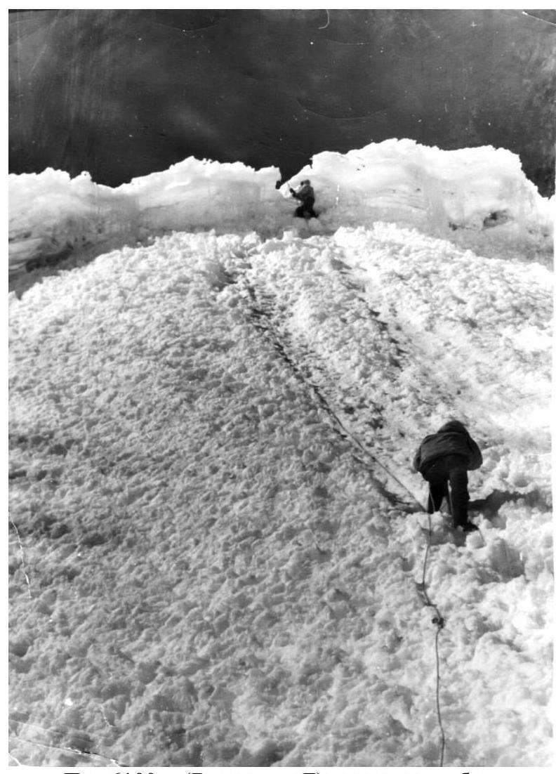
The second rocky outcrop (section 4) is bypassed on the right (i.e., from the eastern side) along the edge of snow and rocks. The rocks are monolithic granite with few cracks. The first climber has to cut steps and drive in ice screws. Above the 2–3 rocky outcrops, a cornice overhangs. Exiting to the ridge at this point is hazardous. We traverse to the third rocky outcrop (section 5) via a snow-and-ice slope with a steepness of 50–60° (50–60 m). We exit to a comfortable platform, sheltered by a large ledge, via easy rocks of the third rocky outcrop. The entire group assembles here (section 6). We overcome the final (section 7) snow-and-ice ascent. After cutting through a small cornice at this point, we exit to the ridge (at 16:20). The key sections R4–R7 are passed. The ridge (section 8) is snow-and-ice. To the left, steep snow slopes (up to 65°) descend, and to the right, there are overhanging cornices. On the ridge itself, the snow cover is no more than 5 cm, and although the altitude gain is insignificant, it is necessary to organize screw belays. We approach section 10. From this point, the rocky ridge steeply rises upwards. We bypass the rocky section of the ridge on the right via a névé with a steepness of 40–50°. We ascend along the edge of snow and rocks. Belays via ice axe. We exit to the saddle between the main peak (on the left) and the false peak (on the right). From the saddle to the peak, a snow-and-ice slope leads. The snow cover is up to 5 cm. The slope's steepness is up to 70°; belays are via screws (section 11).
From the summit of the 6100 m peak to the north, a huge snow-and-ice cornice overhangs. We built a cairn at the beginning of the cornice on rocks.
The descent route from the peak:
- follows the ascent route to the false saddle;
- then along the ridge to the lower part of the saddle between the 6100 m peak and Peak Krylenko.
Recommendations for the route
- The route should be started early in the morning.
- The entire group should wear crampons.
- It is mandatory to bring a tent, bags, and down gear.
- Necessary screws: ice screws — 5 pcs., rock screws — 8 pcs.
- Bypassing the second rocky outcrop on the right (from the western side) to exit to the ridge.
- Descent from the peak can be done either via the ascent route or by descending to the saddle between the 6100 m peak and Peak Krylenko and then down to the "Snezhný" Glacier.
- Overnight stay can only be organized on the ridge.
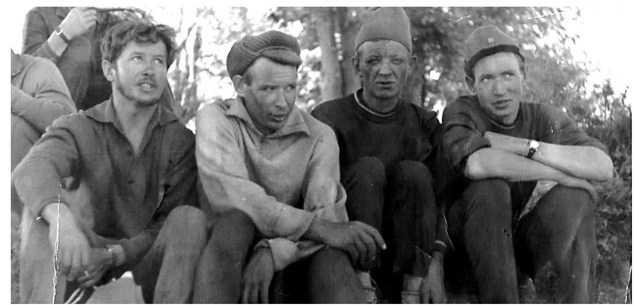
Group composition
- Yazovskikh G. S. — 1st sports category — leader
- Potapkin B. K. — 2nd sports category — participant
- Veselov K. P. — 2nd sports category — participant
- Yazovskikh V. S. — 2nd sports category — participant.
Release officer — Kuznetsov A. F. — Master of Sports — senior instructor.
Proposal for route assessment
Having experience of ascents in the Caucasus, Tian Shan, and Pamir, we propose to assess the route we took as category 4A.
Table of main route characteristics
Route category 4A, combined, from the south.
Approximate route length 1200 m, including complex sections:
- rocky — 120 m
- ice — 200 m
- snow — 80 m
Average steepness of the route — 45°, including complex sections:
- rocky — 70°
- ice — 60°
- snow — 55°.
Time of exit from the assault camp at 9:00 on August 19, 1967.
Time of reaching the summit at 19:00. Time of return to the assault camp — 15:00 on August 20, 1967.
Total travel time — 16 hours.
| № | Steepness | Length | Nature of the section | Difficulty | Passage technique/Belay | Rock screws | Ice screws |
|---|---|---|---|---|---|---|---|
| 1 | 45° | 280 m | Snow-and-ice slopes | Average | Steps, ice axe, ice screws | – | 5 |
| 2 | 65° | 60 m | Monolithic rocks | Average | Via ledges | – | – |
| 3 | 55° | 120 m | Destroyed rocks | Average | Via ledges | – | – |
| 4 | 70° | 110 m | Monolithic rocks, ice, snow | Difficult | Rock and ice screws | 10 | 6 |
| 5 | 20° | 20 m | Ice | Difficult | Steps, ice screws, ledges | – | 2 |
| 6 | 50° | 60 m | Rocks | Average | Via ledges | – | – |
| 7 | 55° | 60 m | Snow, ice, cornice | Difficult | Ice axe, ice screws | – | 4 |
| 8 | 10° | 50 m | Snow, ice | Average | Screws, ice axe | – | 2 |
| 9 | 30° | 17° | 60 m | Snow, ice | Average | Ice axe, ledges | – |
| 10 | 40° | 200 m | Snow | Average | Ice axe | – | – |
| 11 | 75° | 80 m | Ice, rocks | Difficult | Ice and rock screws | 2 | 6 |
| 12 | 15° | 60 m | Snow | Average | Ice axe | – | – |
Proposals for naming the peak
In the note left in the cairn on the peak, we wrote that, by right of the first ascenders, we propose to name the peak after the remarkable man — Dmitry Efimovich Vasiliev.
D. E. Vasiliev was a talented organizer who devoted all his strength and time to his beloved work and people, an irrepressible romantic and lover of life, a man of great erudition and culture, demanding and collected, a man of great scope and generous soul. A rich, diverse, and original personality — so he is remembered by those who had the chance to work with him and know him.
D. E. Vasiliev was born in 1902 in the working-class Ural settlement of Sukhsun into a worker's family. In 1922, he joined the Komsomol, and in 1927, he became a communist, and from then on, his entire bright life was inextricably linked with the party, its successes, and difficulties. He worked wherever the party directed him. During the harsh years of the Great Patriotic War, D. E. Vasiliev was entrusted by the Party and Government to organize and lead one of the most important sections of the defense industry in the Urals.
Dmitry Efimovich's organizational abilities were especially fully revealed in the last years.
The Government highly appreciated his merits in strengthening the defense power of our Motherland, awarding him three Orders of Lenin. He was awarded the title of Laureate of the State Prize.
D. E. Vasiliev died in 1961. He is buried in Moscow.
Peak D. E. Vasiliev is located in the upper reaches of the Fedchenko Glacier — the largest valley glacier in the world. In the headwaters of the Fedchenko Glacier (from the Yazgulem pass to the point where the Vítkovsky Glacier flows into it), it is bounded to the east by a system of mountains with a complex structure. This system is called the "Gory yuzhnoy gruppy Fedchenko" (Mountains of the southern group of Fedchenko). The side glaciers descending to the Fedchenko Glacier from the main ridge of the system are divided by mountain spurs. The Snezhný (or Sredny?) Glacier is one such lateral glacier. It smoothly transitions into the Fedchenko Glacier. A steep ascent leads into the depth of the cirque along a gentle névé field, where only occasional crevasses are found that are easy to bypass. Peak Fickler (6718 m) dominates the cirque. To the southeast, the glacier is bounded by a snow-and-ice wall without any notable peaks, while on the northern ridge, four distinct peaks hang. The nodal peak (6419 m) was conquered in 1960 by a group from the expedition of the SK AS and was named Peak Krylenko. Peak Krylenko is connected to an unnamed peak by a long saddle, on which single rocks are scattered. The slopes of the ridge are snow-and-ice; a steep rocky rib does not lead to the peak. The approximate height of the peak is 6200 m. Two peaks located on this spur, further to the west, have a lower height. On August 19, 1967, a group consisting of: Yazovskikh G. S. (leader), Veselov K. P., Potapkin B. K., Yazovskikh V. S. ascended the aforementioned peak. By right of the first ascenders, the group members proposed to name the peak Peak D. E. Vasiliev.


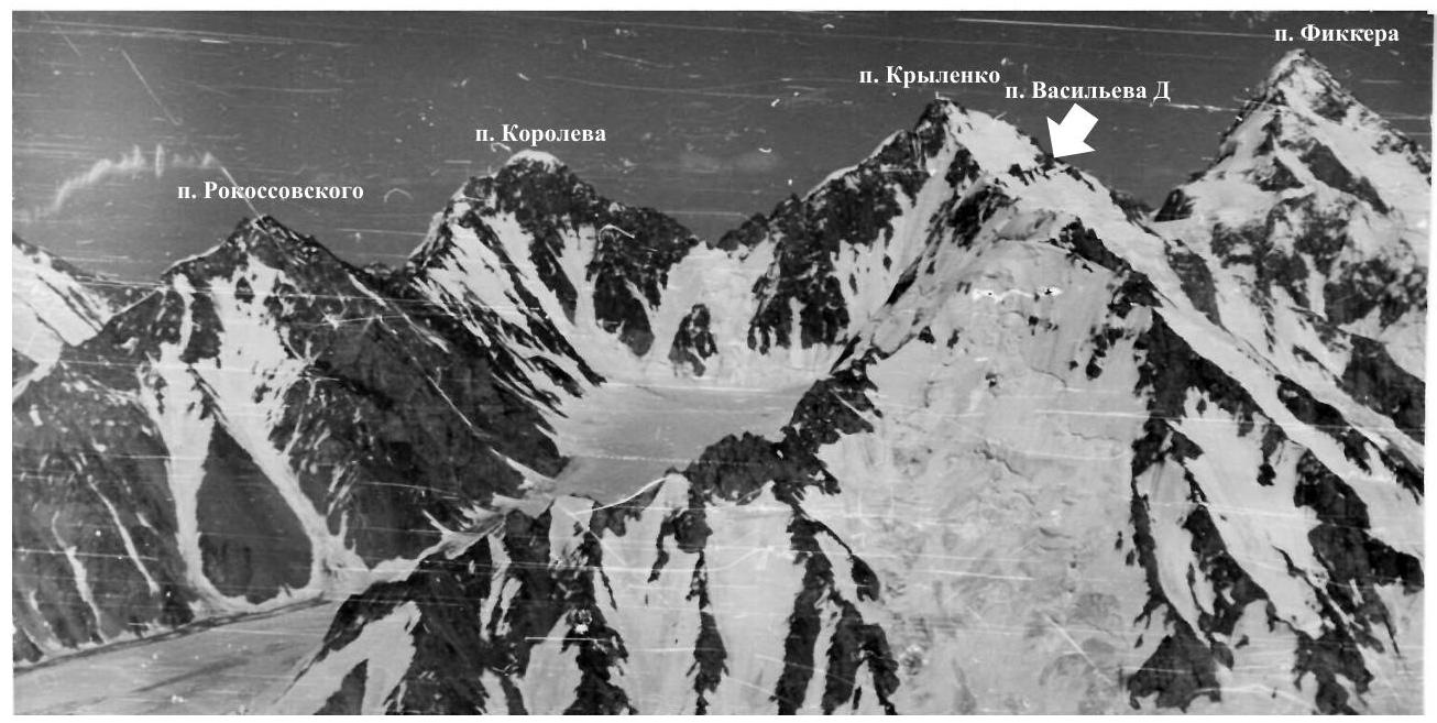
Scheme of peaks in the upper reaches of the Fedchenko Glacier
View:
- Peak Rokossovsky
- Peak Korolev
- Peak Krylenko
- Peak Fickler
- Peak Vasiliev D. (overlaps with Peak Krylenko)
Photo taken from Peak Kovshovykh
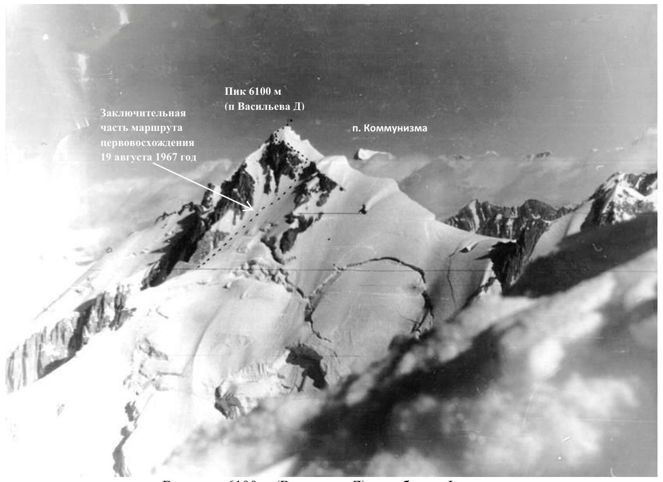
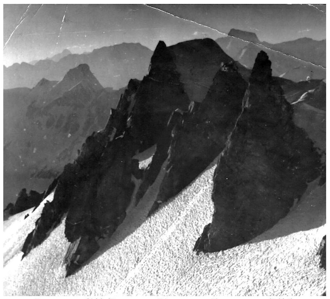
View of Peak 6100 m (Vasiliev D.) from the ridge of Peak Fickler
Route of the first ascent to Peak 6100 m (Peak Vasiliev D.). Eastern slope of the Southern ridge
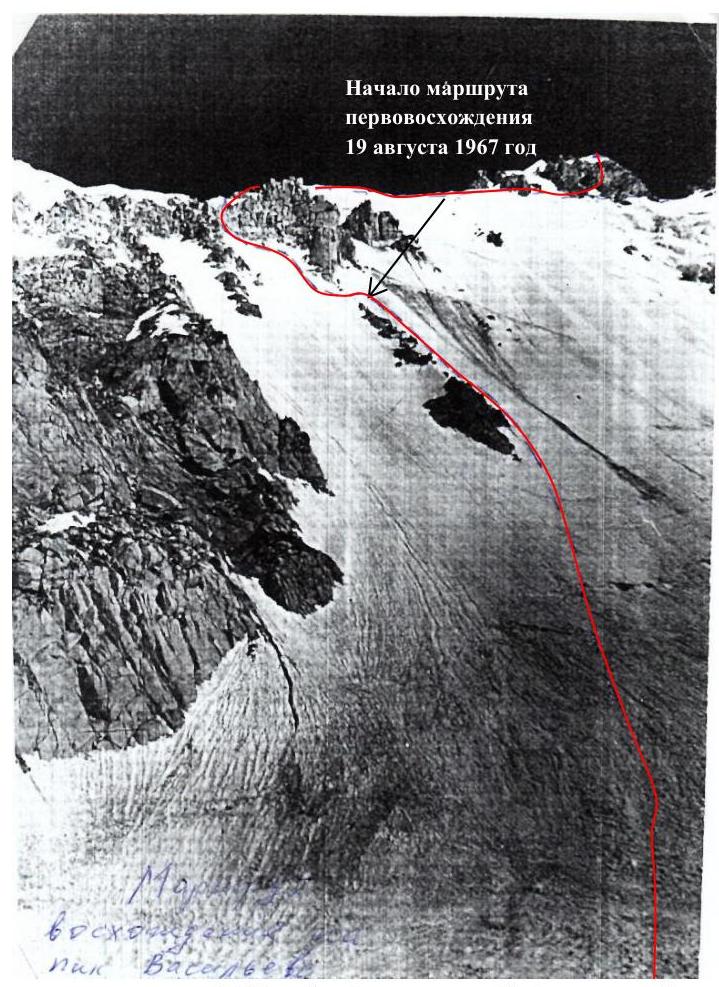
Start of the first ascent to Peak 6100 m (Peak Vasiliev D.)
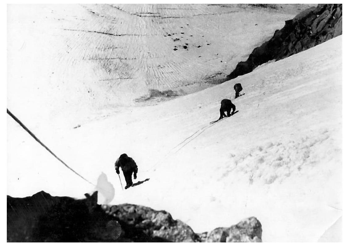
Peak 6100 m (Vasiliev D.) — exit to the ridge
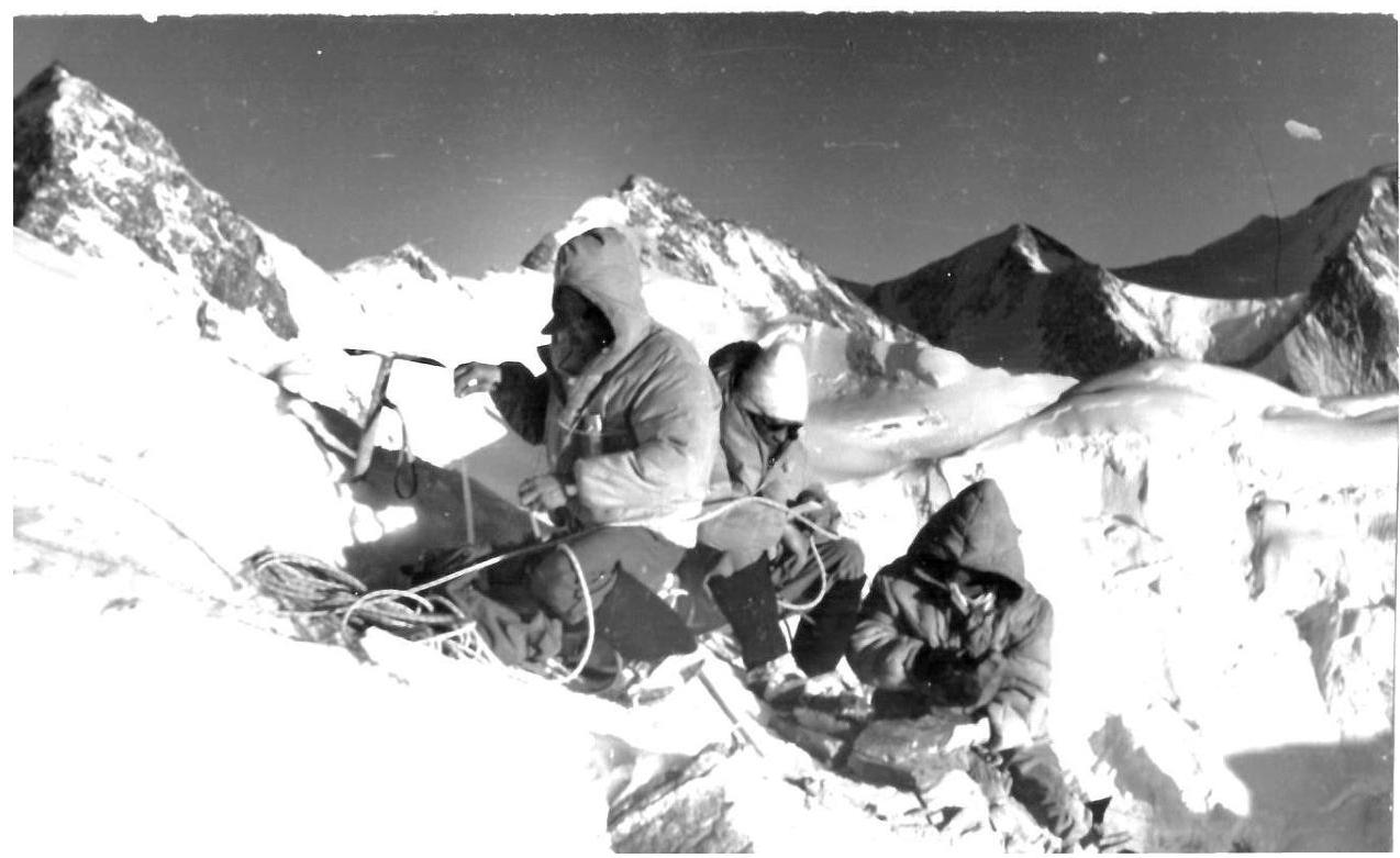
G. Yazovskikh, K. Veselov, B. Potapkin on the summit of Peak 6100 m
View from Peak 6100 (Vasiliev D.), in the distance Peak Communism (7495 m)
Participants of the first ascent to Peak 6100 m (Peak Vasiliev D.):
- K. Veselov
- G. Yazovskikh
- B. Potapkin
- V. Yazovskikh