
1984 Lithuanian Sports Committee Climbing Gathering
Report
on the first ascent to the peak 6004 m "Lituanica" via the northern ridge from Chondzhiraf glacier by the "Polytechnika" team from Kaunas 400, 650, 21 cu, 22 mg, 10 hours. Congratulations to the winners!
TEAM LEADER: Bronius Varsackis. TEAM COACH: Algis Gudyalis.
Committee for Physical Culture and Sports under the Council of Ministers of the Lithuanian SSR 232675, Lithuanian SSR, Vilnius, Zemaite St., 6, phone 63-53-53
Bronius Varsackis — 233005, Lith. SSR, Kaunas, Kapsu St., 101-1, phone 22-57-91
Algis Gudyalis — 233021, Lith. SSR, Kaunas, Kaniu St., 4-17, phone 26-45-91, work phone 75-35-11
Address of Kaunas Polytechnic Institute named after Antanas Sniečkus: 233000, Lith. SSR, Kaunas, Donelaicio St., 43
All heights mentioned in the report are determined using a topographic map.
Brief Historical and Geographical Overview of the Area
The peaks 5350 m (Vrangs), 5998 m (Darius and Girėnas), 6004 m (Lituanica), 5879 m (KPI), 5649 m (Academician Baršauskas) are located in the South-Western Pamir, in the eastern part of the latitudinal section of the Shakhdarin Range, specifically in the Vakhan Range.
The nearest explored climbing areas are the regions of peaks Marx (6726 m) and Engels (6510 m) to the east, and the regions of peaks 6138 m (Armed Forces) and 6038 m (Baikonur) to the west.
During his travels in the Pamir in 1904, B.A. Fedchenko researched and described the area of the Shakhdarin Range, located between the Shakhdara and Pyanj rivers.
Climbing exploration of the Shakhdarin Range began in 1946, when Peak Karl Marx was conquered. In subsequent years, several expeditions were organized, mainly in the area of peaks Marx and Engels. The central part of the Shakhdarin Range began to be explored in 1974, when the walls later named Peak Luknitsky were accidentally spotted by V.P. Nekrasov.
In 1975, an expedition by the Armed Forces led by Nekrasov V.P., establishing a base camp on Lake Zardiv, conquered Peak 5800 m via a 5B category route on the NW edge. This peak was named Luknitsky. In subsequent years, army climbers and other climbing expeditions completed several interesting 5B and 6B category routes in this area, becoming prize-winners in the USSR Climbing Championship.
However, the part of the Shakhdarin Range between peaks Dzhentiva and Marx remained unknown to climbers until 1983 and was only visited by a few tourist groups. The reason for this late exploration is likely due to the fact that the peaks were not visible from populated areas or roads, and climbers were more focused on the areas of peaks Engels, Marx, Luknitsky, and Mayakovsky.
Preliminary reconnaissance of the Vakhan Range area (Yangut, Saryyang, Vnukut, Chondzhiraf valleys) was carried out in 1983 by a reconnaissance group from the Lithuanian SSR Sports Committee (Gudyalis A.V. and Siunitis R.Yu.). They conducted photo surveys of the Vakhan Range peaks and visually studied potential routes.
The most attractive peaks for climbers are those that remain unconquered, especially if they reach or exceed 6000 m in height.
In the summer of 1984, an expedition from the Lithuanian SSR Sports Committee, led by Gudyalis A.V., arrived in the Vnukut valley with the objectives:
- to explore the area from a climbing perspective;
- to conquer previously unconquered peaks;
- to assign corresponding names to them.
The expedition established its base camp at the confluence of the Vnukut and Chondzhiraf rivers, at an altitude of 3529 m, approximately 3 hours' walk from the village of Vrangs.
From a climbing perspective, the area is very interesting for climbers ranging from 2nd category to Candidate Master of Sports. There are many routes to the peaks, ranging from 3A to 5B category, including:
- rock routes;
- combined routes;
- snow and ice routes.
Approaches to the routes take 3–8 hours from the base camp. Many first ascents are possible.
Rivers are turbulent and difficult to cross in the second half of the day. The weather is generally stable, although in August 1984, a sharp cooling was observed, with thunderstorms and rain for a week, resulting in many ascents being unattempted.
The flora and fauna of the valley are not rich. Rarely seen are:
- ephedra;
- rhodiola rosea. In the upper reaches of the Vnukut and Chondzhiraf rivers, there are pastures and summer grazing areas for shepherds.
Location of Peak 6004 m "Lituanica"
The peak is located in the southern spur of the Shakhdarin (Vakhan) Range, between peak 5879 m (Kaunas Polytechnic Institute peak named after Antanas Sniečkus) and peak 5998 m (Darius and Girėnas peak).
To the west, a ridge extends from the peak, suitable for descent.
To Chondzhiraf glacier. To the south — a glacier.
On the northern ridge, a 4B category route has been completed, and a 4A category route has been completed. On the southern ridge, a 4A category route has been completed. To the northwest, there is a counterfort where a 4B category route can also be laid. From the peak, a panorama of the area is visible, as it towers above the surroundings.
Description of the "Lituanica" Route via the Northern Ridge, 4B Category
From the base camp at the confluence of the Vnukut and Chondzhiraf rivers, the path to the bivouac under the peak goes along the right bank of the Chondzhiraf river in the direction of the 5750 m pass. The route begins from the Chondzhiraf glacier.
In the middle part of the ascent to the pass, there are hazardous crevasses (icefall). The icefall is bypassed from left to right. At the 5750 m pass, slightly higher, on a rocky outcrop, a night's stay is recommended. From the base camp to the night's stay — 6 hours.
Further, the route goes in traverse to the right, 150 m along a snowy slope with a steepness of 50°. The approach to the ice wall, 7 m high — a bergschrund. Through the wall, an exit to a snow-ice slope with a steepness of 50–53°, 200 m. Exit to broken rocks (15, 4 category). Approach to a red gendarme, which is bypassed to the left along ledges (25 m, 5 category, 70°) with an exit to icy ledges under an inner corner. The inner corner (40 m, 70°, 5) is passed along ledges. After the inner corner — ledges (40 m, 50°, 4). Along the ledges to a not clearly defined gentle inner corner (40 m, 75°, 5). After it — an exit to walls with cracks (40 m, 75°, 5). From the walls, an exit to the pre-summit ridge. Along the ridge (120 m, 30°, 3) to the summit snow dome (15 m, 30°, 2). Along the dome to the summit 6004 m.
A control cairn is located slightly below the summit on a rocky outcrop. All safety measures: on snow-ice sections — through ice screws, on rock sections — rock pitons and chocks. In total, the following were used:
- 22 ice screws;
- 21 rock pitons and chocks.
Descent is along a straightforward ridge to the west from the summit, approximately 3B category. The entire route to the base takes 10 hours.
Route Diagram
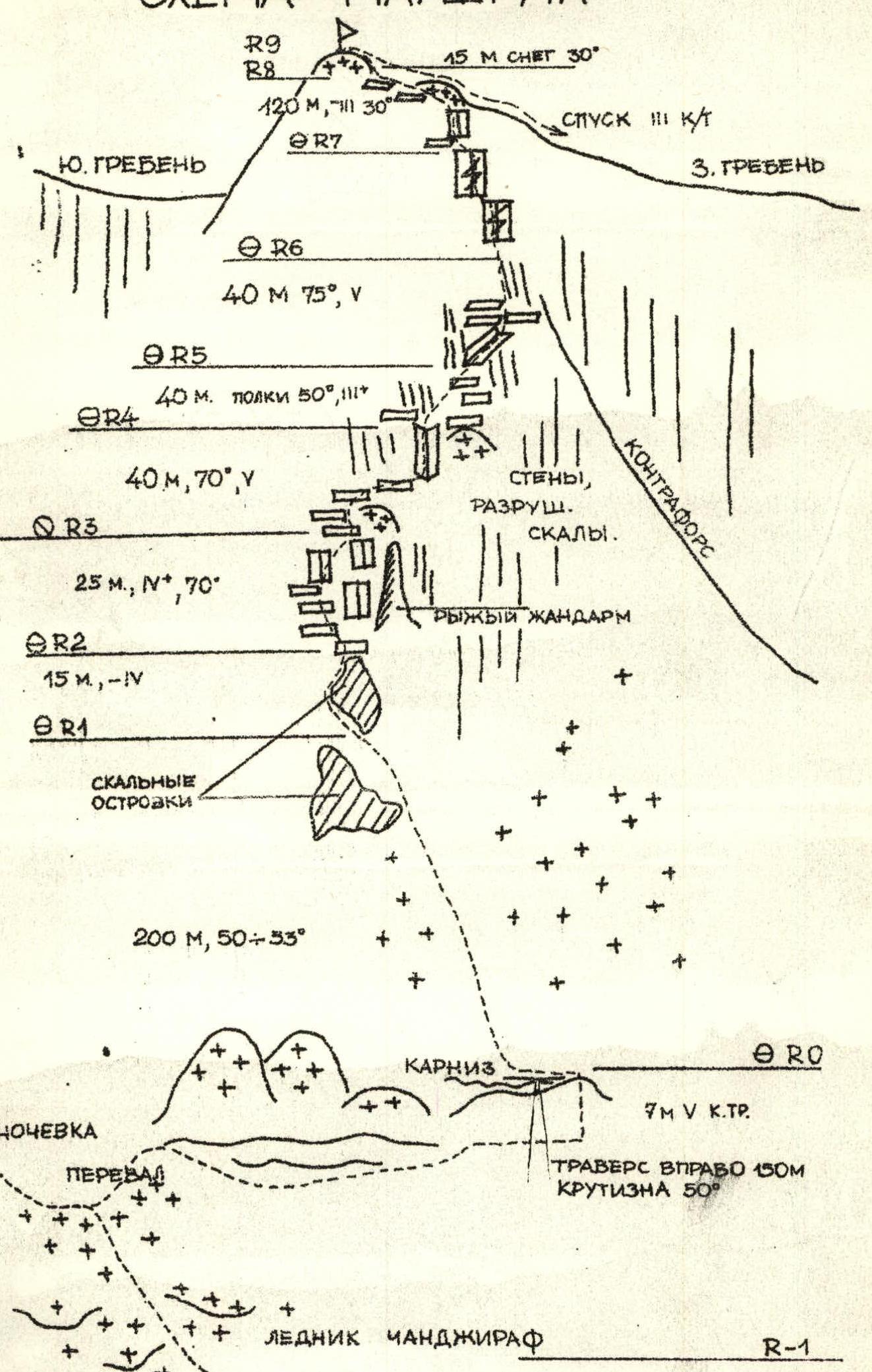
| Section | Category of Difficulty | Steepness | Length | Relief | Pitons | Ice Screws | Chocks | Remarks |
|---|---|---|---|---|---|---|---|---|
| R0–R1 | 5 | 50–53° | 200 | snow-ice | 20 | — | — | Ropes were used |
| R1–R2 | 4 | 60° | 15 | broken ledges | — | 1 | — | 1 rope, 2 on ropes |
| R2–R3 | 5 | 70° | 25 | broken rocks | — | 1 | 1 | |
| R3–R4 | 5 | 70° | 40 | inner corner | — | 2 | 2 | |
| R4–R5 | 4 | 50° | 40 | ledges | — | — | 2 | Rockfall hazard! |
| R5–R6 | 5 | 75° | 40 | inner corner | — | 2 | 1 | |
| R6–R7 | 5 | 75° | 40 | walls with cracks | 2 | 2 | — | Rockfall hazard! |
| R7–R8 | 3 | 30° | 120 | ridge | — | — | — | |
| R8–R9 | 2 | 30° | 15 | snow | — | — | — | Safety through outcrops |