Peak 6004 (Lituanika) via the Southeast Ridge
I. Category: High-altitude technical
- South-West Pamir, Chondzhirav valley
- Peak 6004 (Lituanika) via the Southeast Ridge
- Proposed — 4A category of difficulty; combined, first ascent
- Elevation gain: 650 m, length 1400 m
Length of sections with 4–5 category of difficulty — 160 m. Average steepness of sections — 70°
- Pitons driven:
Rock – 10, chocks – 4.
- Team's travel hours: 14 and days – 2.
- Overnight stays: 1 on a snow-ice slope, on talus.
- Leader: AVULIS Arvidas Antanovich 2nd sports category
Participants:
- KLЁKIS Edvardas Antanovich 1st sports category
- PAULIKAS Vidmantas Juozovich 2nd sports category
- PLYSHEVSKY Mikhail Alexandrovich Master of Sports
Coach: PLYSHEVSKY Mikhail Alexandrovich
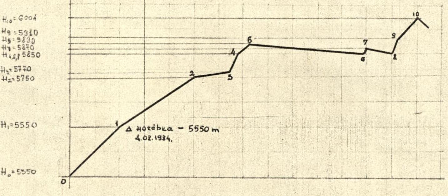
II. Departure to the route August 4, 1984, summit of Peak 6004 (Lituanika), return — August 5, 1984.
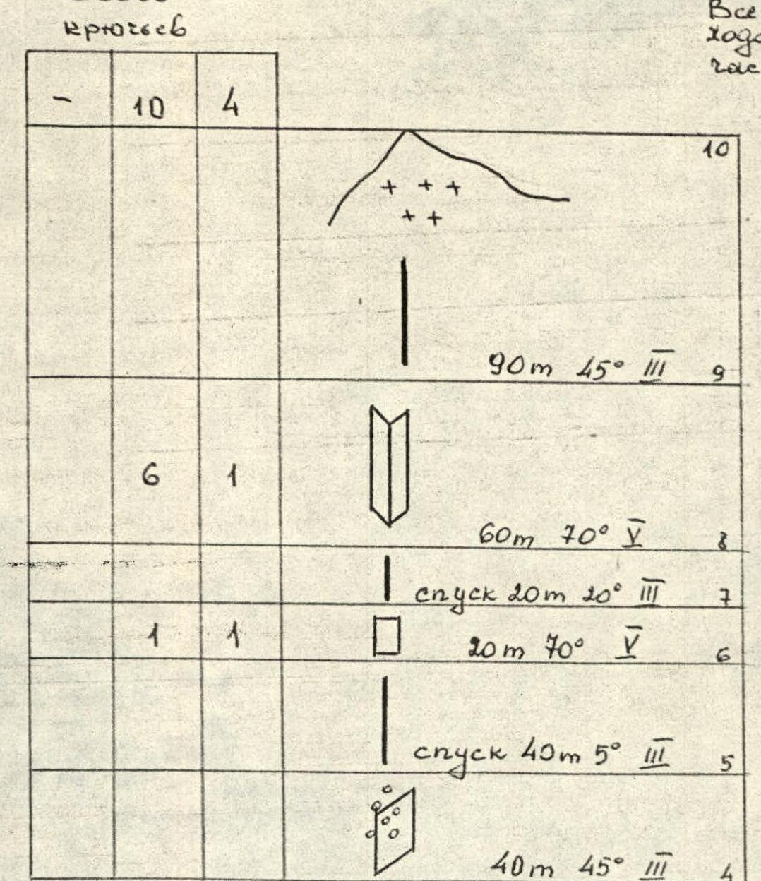
ROUTE PROFILE M 1:10000

R1 Panorama of the area
August 18, 1984 16:00. "Jupiter-12" 35 mm. Distance 7.4 km. Height 5449 m (from the summit).
BRIEF OVERVIEW OF THE ASCENT AREA
Peak 6004 (LITUANIKA) is located at the end of the Chondzhirav valley. It is the highest point in the valley. The approach to the initial bivouac in the Chondzhirav valley from the Vrang settlement takes 6–7 hours.
The path goes as follows:
- From the settlement, it follows the left side of the Vrang River (Vnukut),
- then — on the right side of the Chondzhirav River,
- further — on the left side of the Chondzhirav River.
The initial bivouac can be set up at a pasture near a shepherd's hut (3 hours walk along the Chondzhirav River).
A detailed description of the ascent area is available in the report of the first ascenders, led by B. Varsatskis, made on August 6, 1984.
- VIII. 14. 17:00. Vega 80 mm. Distance 0.5 km; Height 5600 m. Crossing the glacier does not present great difficulties, although the middle part of the glacier is closed, with large crevasses.
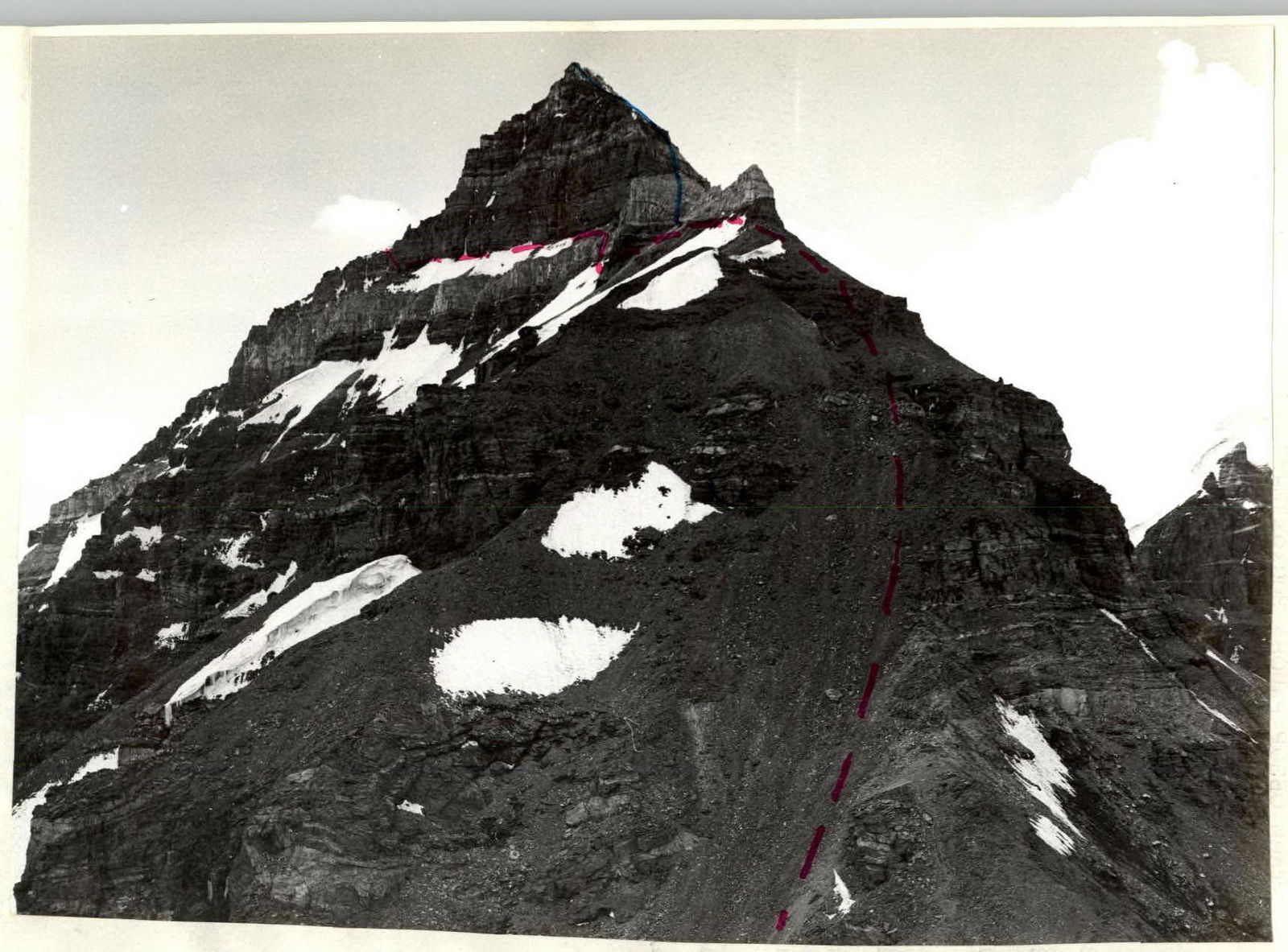
Section R0–R1 — is the ascent to the col between 6004 and 5998 along an ice slope with an average steepness of 40°. Done in crampons.
R1–R2 — ascent along a talus slope to a gendarme. R2–R3 — the gendarme is bypassed on the left along a snowy slope with an average steepness of 30–40°. Further, the ridge is blocked by a 40 m sheer wall. We bypass this wall on the left, traversing 80 m on the same snowy slope. Although it is more rational and logical to ascend the wall here.
R3–R4 — ascent up a vaguely defined inner corner. Rocks of medium difficulty, but very broken, with some places having ice accretions. Piton belay.
R4–R5 — exit to the ridge along an inclined slab covered with talus. On the right side, at the highest point, a control cairn was set up.
R6–R7 — a 20 m wall of difficult climbing is passed on the right side. In the lower part, the rock is not solid, crumbly, with few holds.
R7–R8 — a slight descent along a sharp ridge to a depression before the summit tower.
R8–R9 — the first ascent to the summit tower along a clearly defined inner corner. Climbing is difficult, especially at first (possible with artificial aids). Rocks are heavily broken. Caution!
R9–R10 — first along a simple ridge, then along a snowy slope, we reach the summit.
The total ascent from the col to the summit took 7 hours. Descent was made via the ascent route. The descent to the col took 4 hours. If there are no items left on the col, a simpler descent from the summit can be made along the southwest ridge — not more than 3A category of difficulty.
TACTICAL ACTIONS OF THE TEAM
From the initial bivouac, the group departed on August 4, 1984, at 16:00 and reached the col between 6004 and 5998 in 3 hours. They stopped there for the night.
On August 5, 1984, at 9:00, the group continued the ascent along the southeast ridge of Peak 6004 and by 16:00 reached the summit. The descent was made via the ascent route, as bivouac equipment was left on the col.
To ensure safety on the route, sections R3–R4, R6–R7, R8–R9 were passed with piton belay, followed by the organization of rope protection.
ROUTE SCHEME M 1:2000
Continuation on the next sheet 80 m, 60–70°, IV Traverse of a snowy slope 30–40°, III
200 m, 30–35°, II, 1.5 travel hours.

Continuation of the scheme
Total pitons: – 10 4
90 m, 45°, III, R9 60 m, 70°, V, R8 Descent 20 m, 20°, III, R7 20 m, 70°, V, R6 Descent 40 m, 5°, III, R5 40 m, 45°, III, R4
Total travel hours 8.5 hours.