PASSPORT
-
Class: high-altitude technical. 2. South-West Pamir, Shahdara Range, Vahan Range, Chondzhirav valley. 3. Peak 5879 m via South Ridge from 5650 m col. 4. Proposed 2B category; first ascent. 5. Height difference: 780 m; length 2400 m, average steepness of main sections 35°.
-
Pitons used: ice screws — 6. 7. Team's travel time: 5.5 hours (1 day). 8. Leader: PLYASKUS Jonas Stasevich. Team members: GUDYALIS Algis Vitautovich — Candidate Master of Sports, KRIPAITITE Ruta Povilonas — 2nd sports category, GRIGAS Zenonas Zenonovich — 2nd sports category, MACHERNIS Vidmantas Pyatrovich — 3rd sports category.
-
Coach: GUDYALIS Algis Vitautovich.
-
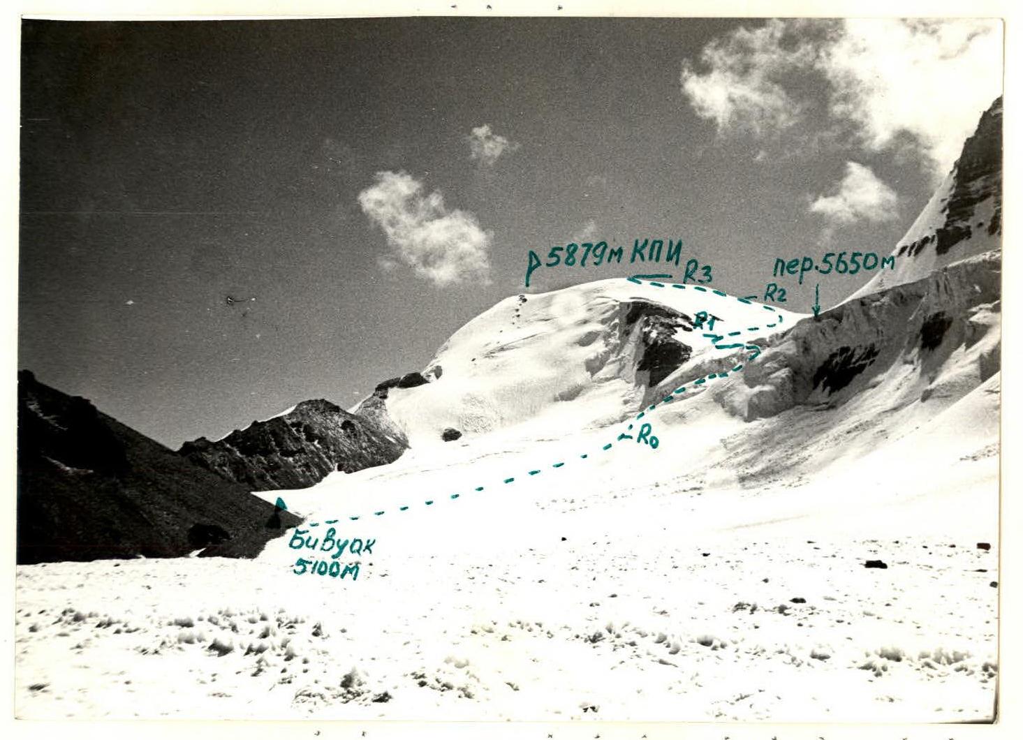
Route approach on August 6, 1984. Photo #1. Peak 5879 m (KPI) — general view. Photographed from Chondzhirav glacier, August 17, 1984. Distance 3 km. "Helios-44M" lens.

Brief Overview of the Area
Peaks Vrangs (5350 m), Darius and Girenas (5998 m), Litvanika (6004 m), KPI (5879 m), and Academician Barshauskas (5649 m) are located in the South-West Pamir, in the eastern part of the latitudinal section of the Shahdara Range, specifically in the Vahan Range.
The nearest explored areas for climbers are the areas of Peak Marx (6726 m) and Engels (6510 m) to the East, and the areas of Peaks Armed Forces (6138 m) and Baikonur (6038 m) to the West.
Traveling through the Pamir in 1904, B. A. Fedchenko explored and described the area of the Shahdara Range, located between the Shahdara and Panj rivers.
Climbing exploration of the Shahdara Range began in 1946: Peak Karl Marx was conquered this year. In subsequent years, a number of expeditions were organized, mainly in the areas of Peaks Marx and Engels. The central part of the Shahdara Range began to be explored in 1974, when the walls, later named Peak Luknitsky, were accidentally noticed by V. P. Nekrasov. In 1975, an expedition of the Armed Forces, led by Nekrasov V. P., based their base camp on Zardiv Lake, and conquered Peak 5800 m via a 5B category route on the NW edge. This peak was named Luknitsky.
In subsequent years:
- army climbers, as well as other climbing expeditions, completed a number of interesting 5B and 6B category routes in this area;
- becoming prize-winners of the USSR Climbing Championship.
However, the part of the Shahdara Range between Peaks Djantiv and Marx remained unknown to climbers until 1983 and was only visited by rare groups of tourists. The reason for such late exploration of the area is apparently that:
- the peaks of these mountains are not visible from populated areas and roads;
- and also more attention from climbers to the area of Peak Engels, Peak Marx, Peak Luknitsky, and Peak Mayakovsky.
Preliminary reconnaissance of the Vahan Range area (Yamchung, Saryang, Vnukut, and Chondzhirav valleys) was carried out in 1983 by a reconnaissance group from the Sports Committee of the Lithuanian SSR (Gudyalis A. V., Simutis R. Yu.). Photographic surveys of the peaks of the Vahan Range and visual examination of routes were conducted.
The most attractive peaks for climbers are unclimbed peaks, especially if they reach or exceed 6000 m.
In the summer of 1984, an expedition from the Sports Committee of the Lithuanian SSR, led by Gudyalis A. V., arrived in the Vnukut valley with the goal of exploring this area from a climbing perspective and climbing previously unclimbed peaks.
The expedition set up its base camp at the confluence of the Vnukut and Chondzhirav rivers, at an altitude of 3520 m, approximately 3 hours' walk from the village of Vrang.
From a climbing perspective, the area is interesting for climbers from 2nd sports category to Candidate Master of Sports inclusive. There are many routes to the peaks, ranging from 3A to 5B category, including rock, combined, and snow-ice routes.
Approaches to the routes take:
- 3–8 hours from the base camp.
There are many possibilities for first ascents in the area. Rivers are turbulent. In the second half of the day, they are difficult to cross. Weather is generally stable, although in August 1984, a sharp cold snap, thunderstorms, and rains were observed for a week, resulting in many ascents not being carried out.
In the upper reaches of the Vnukut and Chondzhirav rivers, there are pastures and summer shepherds' camps.
Description of the Ascent Route to Peak 5879 m (Kaunas Antanas Sniečkus Polytechnic Institute) via South Ridge from 5650 m col, 2B category.
From the base camp at the confluence of the Vnukut and Chondzhirav rivers, the path to the bivouac on the left lateral moraine of the Chondzhirav glacier goes along the right bank of the Chondzhirav River — 3.5 hours.
Then along the glacier in the direction of the 5650 m col. Under Peak 5223 m, there is a convenient bivouac site on the lateral moraine — 6 hours' walk from the base camp.
The route begins from the bivouac in the direction of the col. In the middle part of the ascent to the col, there are hazardous crevasses (icefall), which are bypassed from left to right. Along the snow-ice slope, with crevasses, steepness 20–25°, we reach the ridge to the left of the col. Caution! To the right, the ridge is cut off by cornices. Further ascent is along the ridge. Steepness increases to 35°; two ropes are traversed with piton protection. The ridge becomes less steep and leads to the summit. A cairn is established on a rock outcrop 2–3 m below the summit. The ascent from the bivouac to the summit takes 3–4 hours.
Descent from the summit is via the ascent route to the bivouac — 1.5 hours. The entire route is traversed in crampons. Time required to complete the route depends on the condition of the snow and ice and, under good conditions, is 5–6 hours.
UIAA Scheme
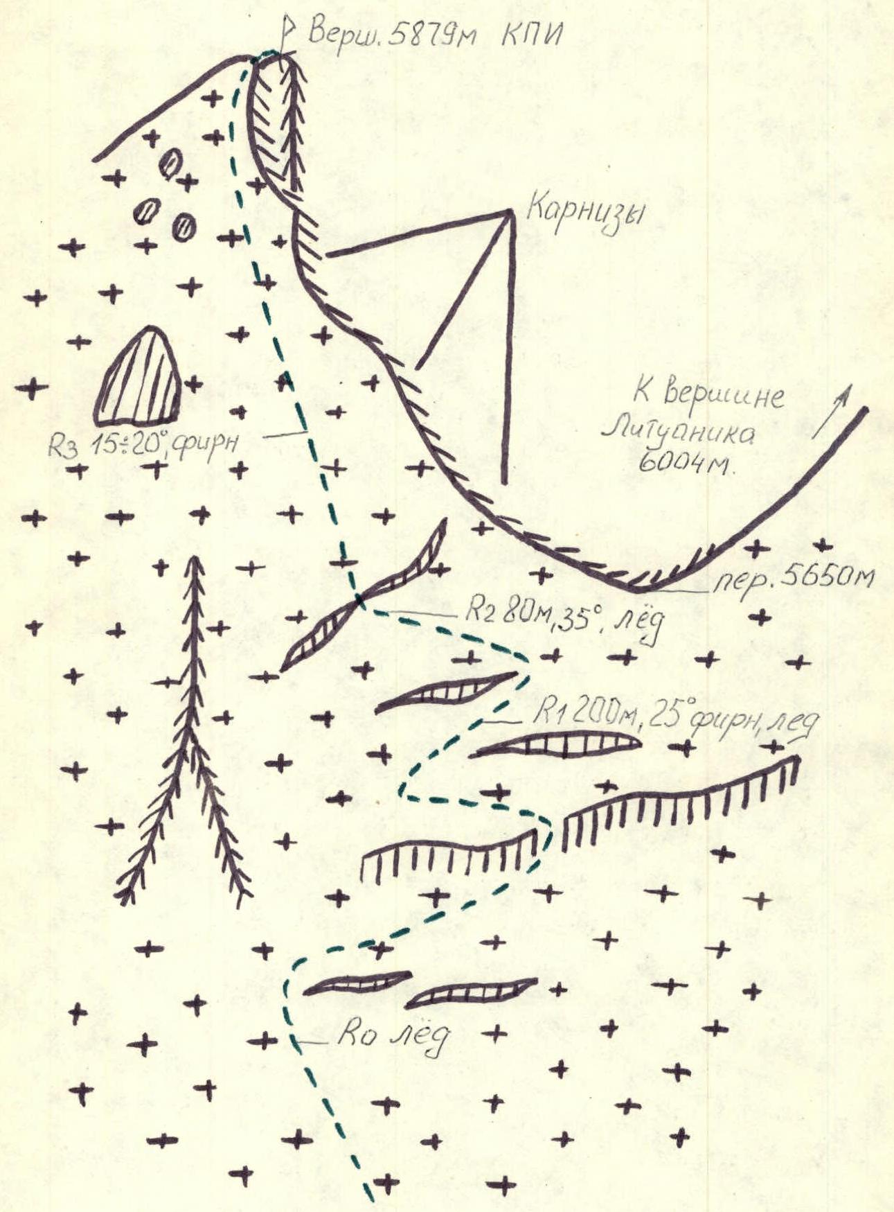
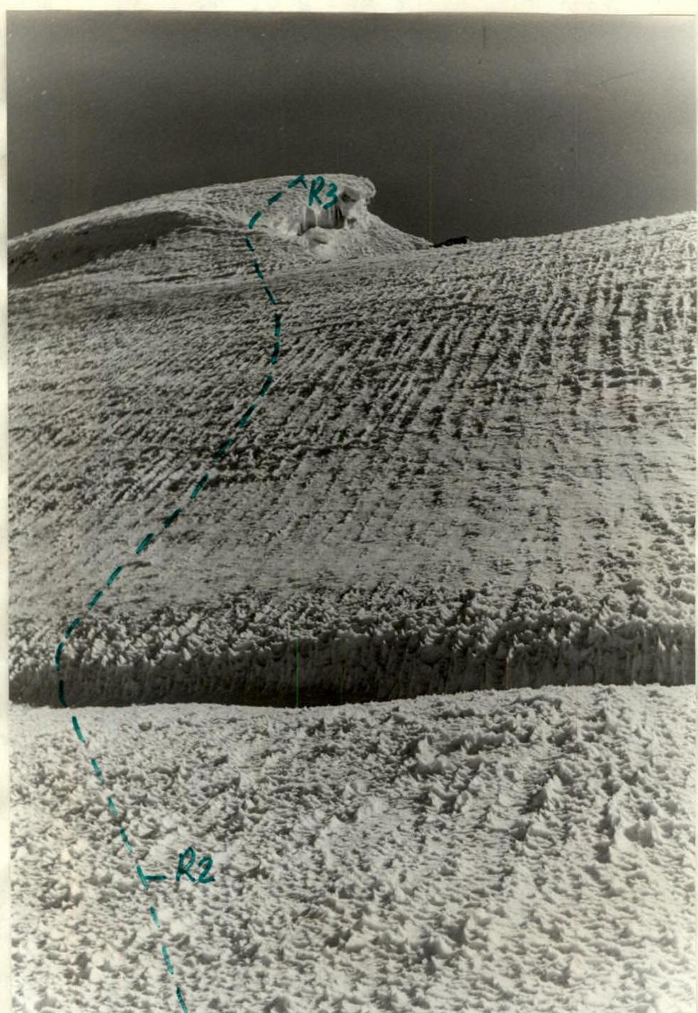
Photo #3. Section of the ascent to Peak 5879 m (KPI). Photographed from 5650 m col on August 6, 1984. "Helios-44M" lens.