Climbing Passport
I. Category: High-altitude technical.
- South-West Pamir, Vakhdarinsky ridge, Vakhan ridge, Vnukut gorge.
- Peak 5649 m (Academician Kazimieras Baršauskas) via the North ridge.
- Proposed category: 4B, combined, first ascent.
- Elevation gain: length:
Length of sections with 4-5 category difficulty – 80 m. Average steepness of main rock sections – 75°. Average steepness of ice sections 40-45°.
- Pitons used: rock – 3, ice – 21, chocks – 5.
- Total hours from base camp – 22 h.
- Overnight stays: I – under the glacier on a grassy site.
- Team leader: PAULIKAS Vidmantas Bovovich
Team members: BUROKAITE Odita Vytautovna, ASAVKIN Alexander Mikhailovich, MačIARNIS Vidmantas Petрович, GUDYALIS Algis Vytautovich
II cat., II cat., II cat., III cat., Candidate for Master of Sports.
- Coach: GUDYALIS Algis Vytautovich
II. Departure to the route: August 16, 1984.
Return: August 16, 1984.
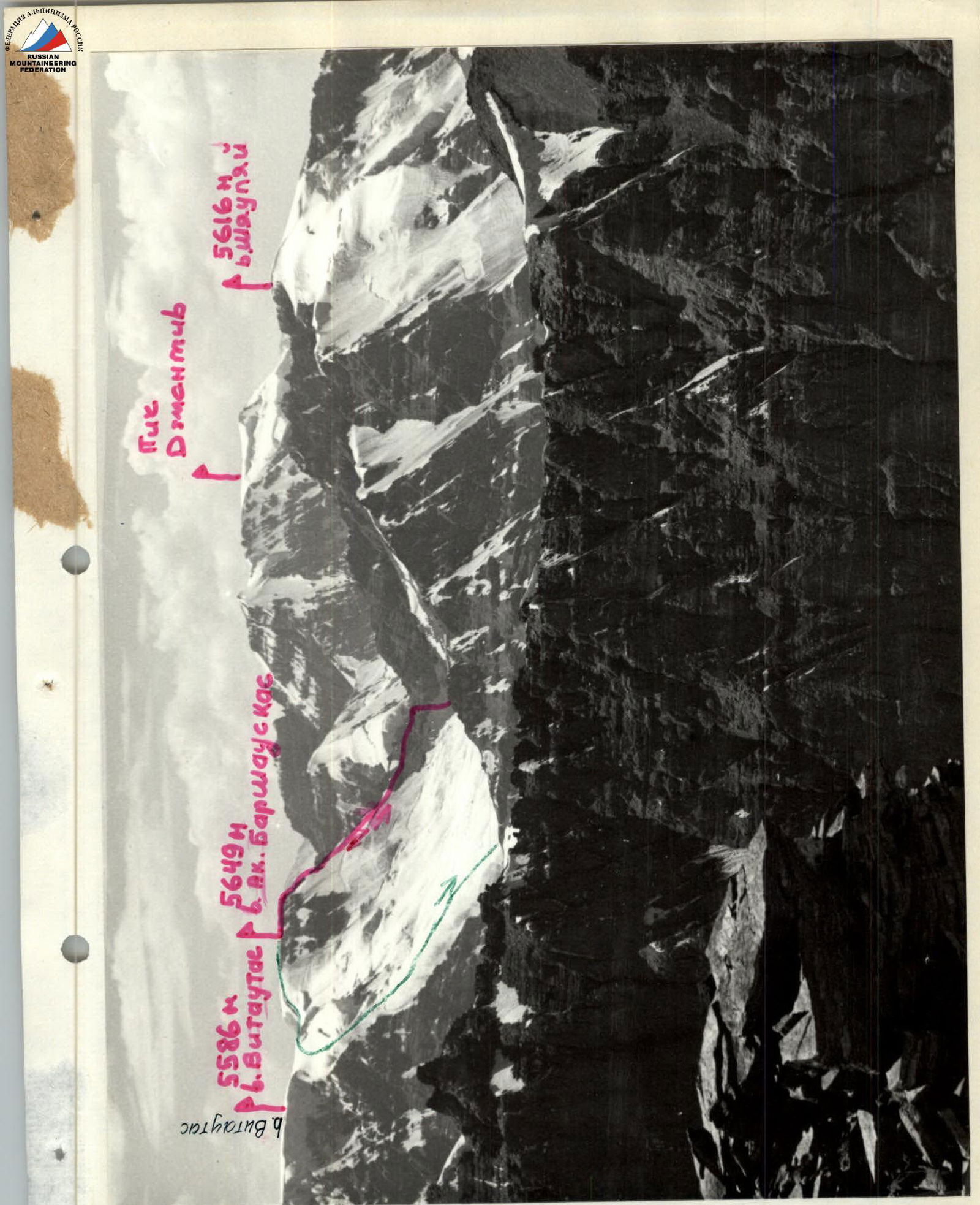
Panorama of the ascent area. View from the North-East. Photo #1. Lens "Industar-50-2" 3.5/50
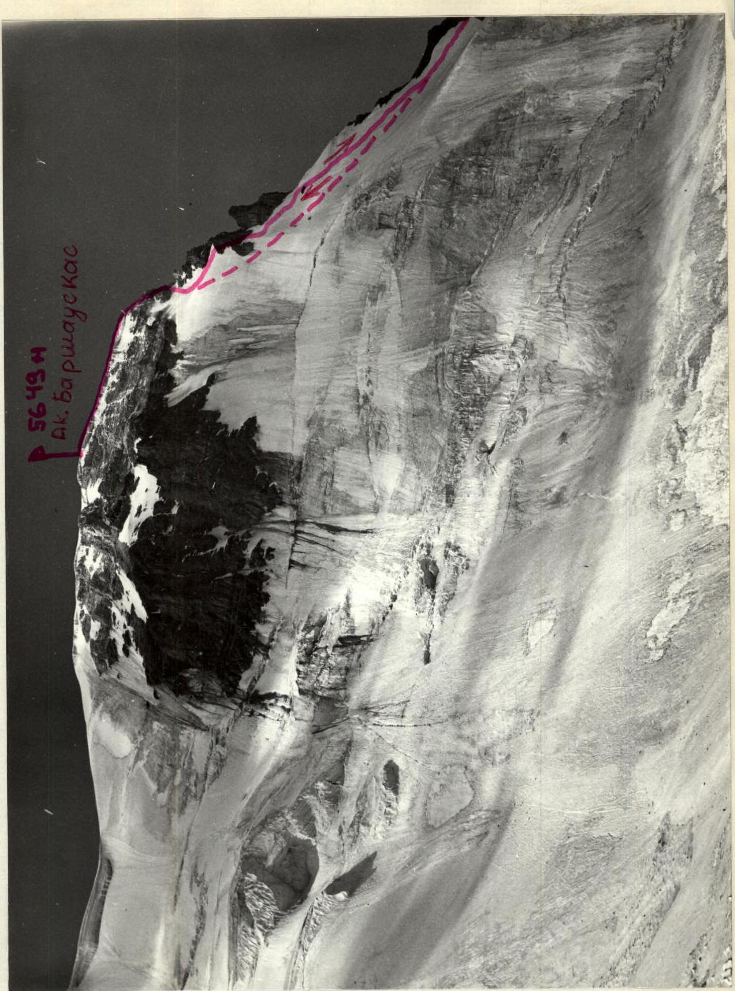
(View from the glacier) View of the summit from the North. Photo #2. Lens "Industar-50-2" 3.5/50 August 14, 1984.

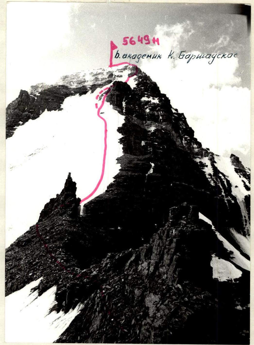
View of the summit from the Lithuanian Alpinists' pass. Photo #4. Lens "Industar-50-2" 3.5/50 August 16, 1984.
General view of the summit from the Šiauliai peak ridge. Photo #7. Lens "Industar-50-2" 3.5/50 August 16, 1984.
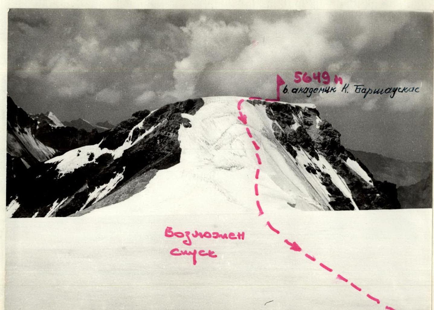
Descent from Academician K. Baršauskas peak towards Vytautas peak is possible. Photo #6. Lens "Industar-50-2" 3.5/50
August 16, 1984.

Brief Overview of the Ascent Area
Approach Description
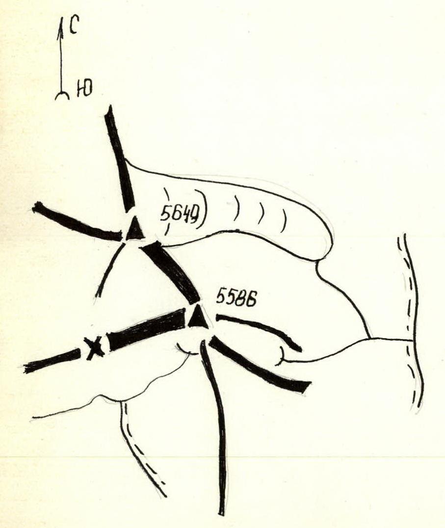
Peak 5649 m (Academician Kazimieras Baršauskas) is located between peaks 5616 m (Šiauliai) and 5586 m (Vytautas). It is the highest point of the cirque formed by the three mentioned peaks. The approach from Vrang village along the right bank of the Vrang river to the Chondzhirav tributary. The approach with a 20-25 kg load takes 4-4.5 hours. At the confluence of the rivers, there is a convenient location for a base camp. Then cross the Vrang river and walk along its left bank. Crossing the river in the afternoon is hazardous (the river becomes turbulent)! Further, a 1-hour walk to the fork, where you turn left and go up the trail. After a 0.5-hour walk, there is a summer shepherd's camp (a convenient spot for tents, with a source of clean water). Then, to the right of the camp, the trail goes up and about 100 meters later, it is convenient to cross the stream flowing down from the cirque. After crossing the stream, ascend the trail, sticking to the left side. From the camp, a 1-hour walk to an intermediate camp under the northern buttress of peak 5586 m (Vytautas). Here is a convenient campsite ("football field").
From the bivouac, ascend the scree, sticking to the right side. After 1 hour of walking, we reach the glacier flowing from the beginning of the cirque. (A convenient spot for a bivouac, with clean water).
Further up the glacier, to the left, the pass is visible (Lithuanian Alpinists' pass), about 1 hour walk to the foot of the 5250 m pass. Ascend the scree to the pass.
From here, routes begin to:
- peak 5649 m (Academician K. Baršauskas) – 4A category difficulty.
- peak 5616 m (Šiauliai) – 3A category difficulty.
On the pass, there is a control cairn.
Tactical Actions of the Team
From the base camp, located at the confluence of the Vnukut and Chondzhirav rivers, the group departed on August 15, 1984, at 15:00. At this time, it is safe to cross the Vnukut river, as after 15:00, the water level rises sharply.
We reached the intermediate camp – a grassy field under the northern buttress of peak 5586 m (Vytautas) – in 2 hours and 30 minutes.
The ascent was planned for August 16, 1984. Departure from the intermediate camp at 7:15. To the glacier, located in the cirque of peaks 5586 m (Vytautas), 5649 m (Academician Kazimieras Baršauskas), and 5616 m (Šiauliai), is almost 1 hour walk. The glacier can be traversed without crampons; there is a gentle exit on the left (in the direction of travel) side. The ascent to the Lithuanian Alpinists' pass (5250 m), located between peaks 5649 m and 5616 m, takes about 2 hours. From the pass, the route begins.
The group worked in two ropes:
- 1 – Asavkin – Paulikas
- 2 – MačIARNIS – Burokaite – Gudyalis.
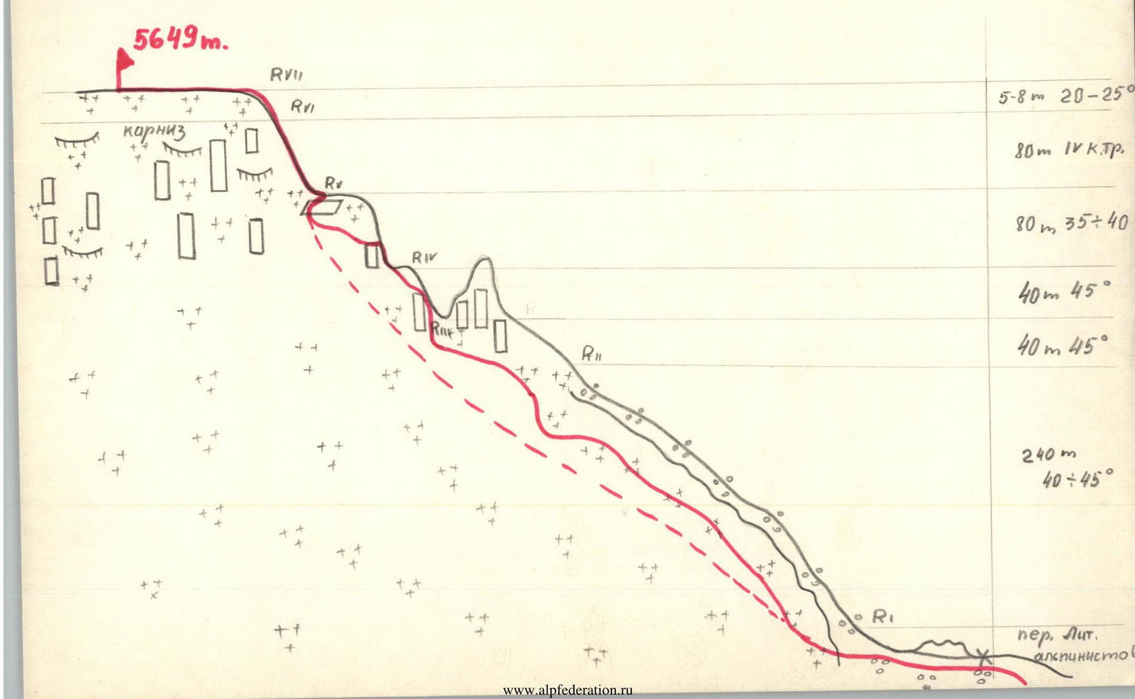
Screes are traversed simultaneously. Belaying is necessary on the snow-ice slope, with a steepness of 45°. Six ropes up to the gendarme. Belaying is with pitons. Crampons are used. The gendarme is bypassed on the left along the snow-ice slope (1 rope). Then our group ascended up the very broken rocks. Rockfall hazard! It is recommended for subsequent climbers to stay on the snow-ice slope until the pre-summit tower rocks. Steepness – up to 40°. Belaying is with pitons (2 ropes). On the rocks – exit to the summit, difficult climbing. Belaying is with pitons (2 ropes). Exit to the summit plateau on ice 5-8 m, steepness up to 30°. The group reached the summit at 17:00. Descent was made via the ascent route, as some gear was left on a convenient platform during the ascent. It is recommended for subsequent climbers to descend along the north-eastern slope between peaks 5649 m and 5586 m. Snow-ice slope, steepness up to 45°. For safety, the group traversed the entire route using fixed ropes.
The total time for the route (from the pass to the summit) for well-prepared groups will be 4-6 hours, depending on the condition of the snow-ice slope.
Route Description by Sections
Along the screes and then along the glacier to the Lithuanian Alpinists' pass, where the route begins. Traverse in crampons.
Section R0-R1 – about 150 m along the screes to the snow-ice slope. Traverse simultaneously.
Section R1-R2 – snow-ice slope, 6 ropes, steepness 40-45°. To the right, there are broken rocks that end in a wall. It is not recommended to traverse them. Rockfall hazard! Possible rockfall triggered by rope.
Section R2-R3 – bypassing the rock gendarme along the snow-ice slope. 1 rope, slope steepness 45°.
Section R3-R4 – ascent along the rocks to the ridge. Rocks of medium difficulty. Steepness 75-80°. Belaying with pitons. Rockfall hazard! Possible rockfall triggered by rope!
Section R4-R5 – snow-ice slope, 2 ropes, steepness 35-40°. To the right, there are broken rocks with icing, which are not recommended for traversing.
Section R5-R6 – ascent to the summit tower. Difficult climbing, 2 ropes, steepness 80-85°.
Section R6-R7 – ice. 5-8 m, steepness 20-25°. Exit to the summit plateau.
The ascent to peak 5649 m (Academician K. Baršauskas) from the Lithuanian Alpinists' pass takes 7 hours. Descent is via the ascent route. It is recommended for subsequent climbers to descend along the north-eastern snow slope.
The ascent takes 20-21 hours.
Time Breakdown
August 15, 1984.
15:00 – departure from the bivouac 18:00 – at the "Edelweiss clearing" bivouac
August 16, 1984.
7:15 – departure from the bivouac 9:00 – reaching the glacier 10:30 – on the pass 17:00 – on the summit 18:00 – start of descent 23:30 – at the bivouac
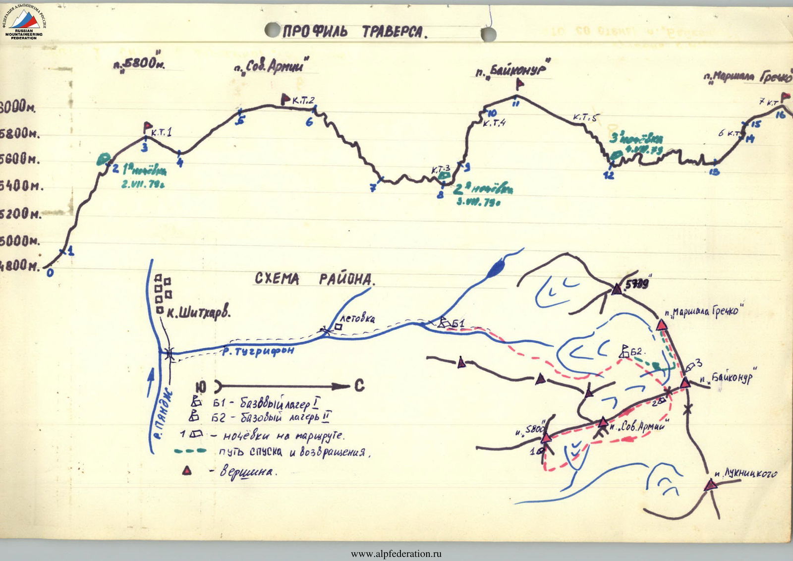
Traverse Profile.