64
Alpinist Activity of the Sports Committee of the Lithuanian SSR
Report
ON THE FIRST ASCENT TO THE SUMMIT 5616 m (ŠIAULIAI) VIA THE SOUTH RIDGE BY THE TEAM OF THE SPORTS COMMITTEE OF THE LITHUANIAN SSR
Leader: BLOŠKIS A.R. Coach: NAVICKAS S.I.
Committee for Physical Culture and Sports of the Lithuanian SSR under the Council of Ministers of the Lithuanian SSR — 232675, Lithuanian SSR, Vilnius, Žemaitės 6, tel. 63–53–53.
Leader: Bloškis Audrius Romualdovich — 235800, Lithuanian SSR, Klaipėda, Vytauto 30–4, tel. 6–35–11
Coach: Navickas Stasys Ivanovich — Lithuanian SSR, Kaunas, Partizanų 104–32, tel. home 75–54–98.
All elevations mentioned in the report are taken from the topographic map.
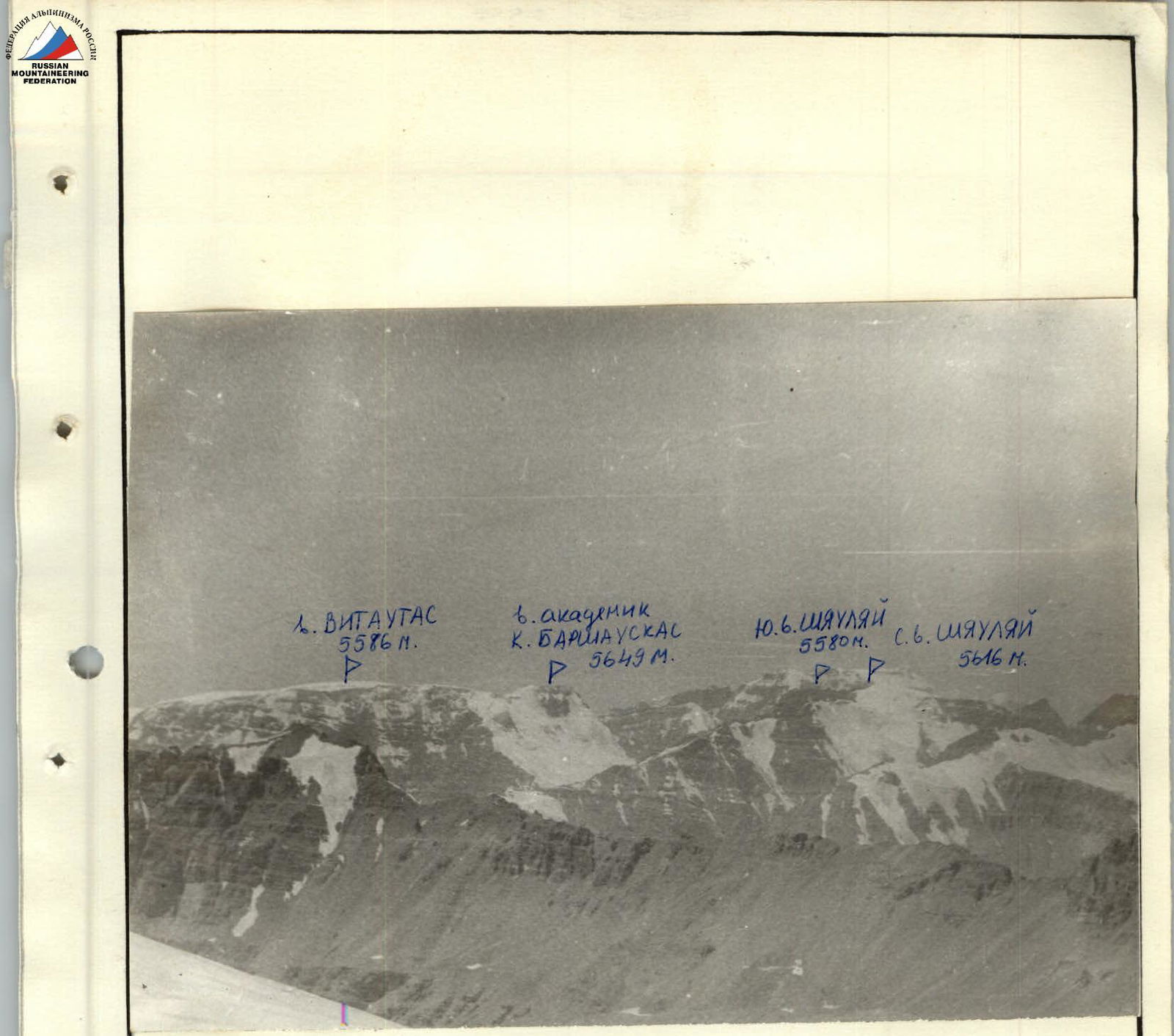
Panorama of the ascent area. View from the east. Photo No. 2. Distance 13,200 m. Lens "Industar-50-2", 3.5/50. August 6, 1984. Peaks:
- 5350 m (Vrang)
- 5998 m (Darius and Girėnas)
- 6004 m (Lituanica)
- 5879 m (KPI)
- 5649 m (Academician Baršauskas)
are located in the South-Western Pamir, in the eastern part of the Shakhdarin Range, specifically in the Vakhan Range. The nearest explored areas by climbers are the areas of Peak Marx (6726 m) and Engels (6510 m) to the east, and the area of Peak 6138 m (Baikonur) to the west. During his travels in the Pamir in 1904, V.A. Fedchenko explored and described the area of the Shakhdarin Range, located between the Shakhdara and Panj rivers. The alpinist exploration of the Shakhdarin Range began in 1946: in that year, Peak Karl Marx was conquered. In subsequent years, a number of expeditions were organized mainly in the area of Peaks Marx and Engels. The central part of the Shakhdarin Range began to be explored in 1974, when the walls, later named after Peak Luknitsky, were accidentally noticed by V.P. Nekrasov. In 1975, an expedition of the Armed Forces led by V.P. Nekrasov, based at the Zardiv Lake, conquered Peak 5800 m via a route of category 5B difficulty on the NW edge. This peak was named Luknitsky. In subsequent years, army climbers, as well as other mountaineering expeditions, completed a number of interesting routes of category 5B and 6B difficulty in this area, becoming prize-winners of the national mountaineering championship. However, the part of the Shakhdarin Range between Peaks Dzhangin and Marx remained unknown to climbers until 1983 and was only visited by a few groups of tourists. The reason for this late exploration of the area should probably be attributed to the fact that the peaks of these mountains are not visible from populated areas and roads, as well as the more focused attention of climbers on the area of Peaks Engels, Marx, Luknitsky, and Mayakovsky. Preliminary reconnaissance of the Vakhan Range area (Yangut, Saryang, Vnukut, and Chondzhirav valleys) was carried out in 1983 by a reconnaissance group from the Sports Committee of the Lithuanian SSR (Gudyalis A. and Simutis R.). Photographic surveys of the peaks of the Vakhan Range and visual examination of routes were conducted.
The most attractive peaks for climbers are those that have not been conquered yet, especially if these peaks reach or exceed 6000 m in height. In the summer of 1984, an expedition from the Sports Committee of the Lithuanian SSR led by Gudyalis A.V. arrived in the Vnukut valley with the aim of studying the area from an alpinist's perspective, conquering previously unconquered peaks, and assigning them corresponding names. The expedition established its base camp at the confluence of the Vnukut and Chondzhirav rivers, at an elevation of 3520 m, approximately 3 hours' walk from the village of Vrang. From an alpinist's perspective, the area is very interesting for climbers ranging from 2nd sports category to Candidate Master of Sports. There are many routes to the peaks ranging from category 3A to 5B difficulty, including rock, combined, and snow-ice routes. The approaches to the routes take 3–8 hours from the base camp. Many first ascents are possible. The rivers are turbulent and difficult to cross in the second half of the day. The weather is generally stable, although in August 1984, a sharp cooling was observed, with thunderstorms and rain for a week, resulting in many ascents not being carried out. The vegetation in the valley is not rich. Ephedra and Rhodiola rosea are rarely found. In the upper reaches of the Vnukut and Chondzhirav rivers, there are pastures and summer shepherds' camps.
Brief overview of the ascent area
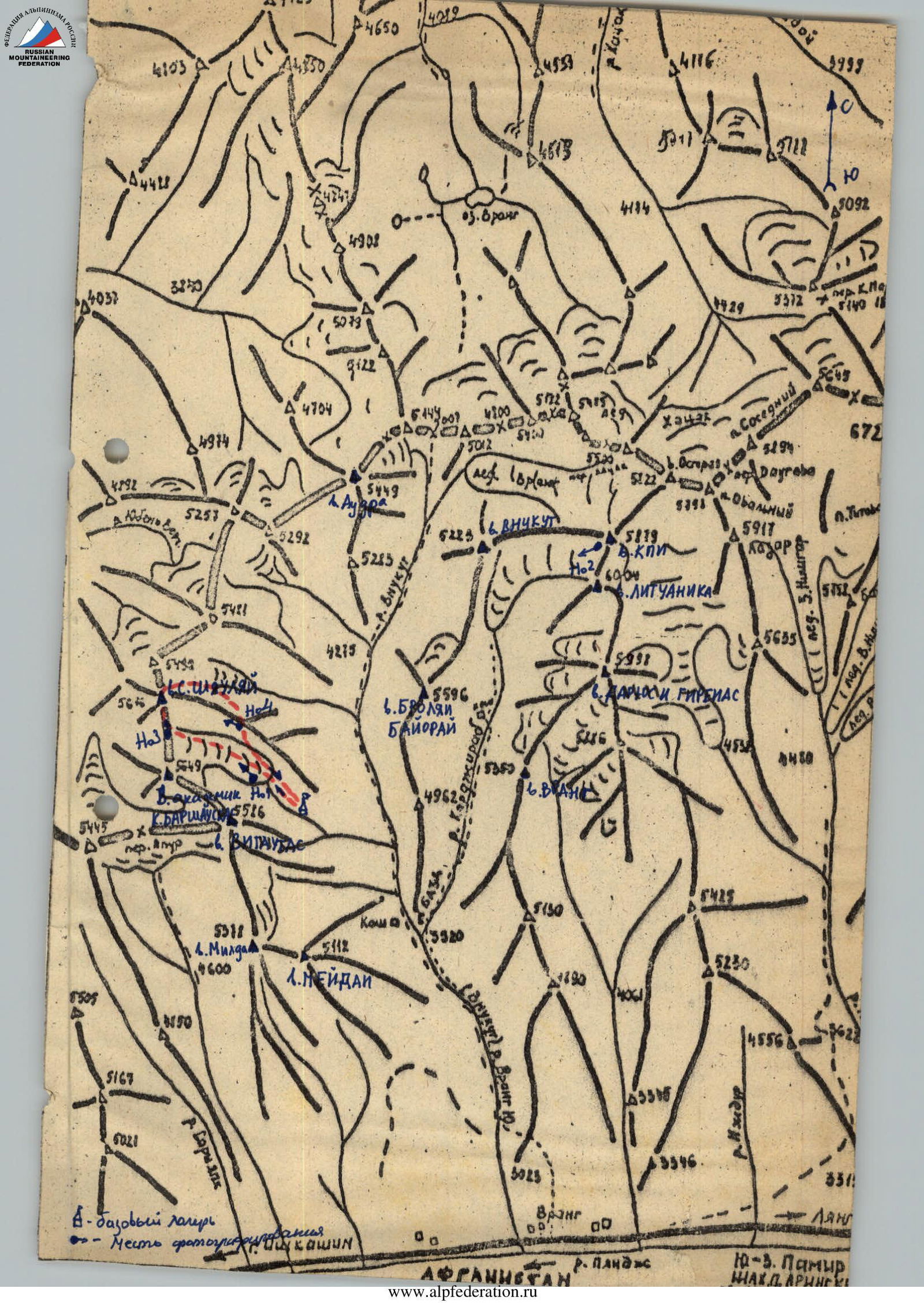
Peak 5616 m (Šiauliai) is located at the end of the glacier cirque of peaks 5616, 5649, and 5586. From the Edelweiss meadow, the ridge is clearly visible and lies directly ahead, looking towards the glacier. To the left of this ridge is the highest peak of the cirque, 5649 m (Academician Kazimieras Baršauskas). The journey to the initial bivouac in the cirque takes 6–7 hours. From the village of Vrang, the path goes along the right bank of the Vrang (Vnukut) river, and then from the confluence of the Vrang and Chondzhirav rivers, along the left bank of the Vrang (Vnukut) river. The initial bivouac can be set up near a shepherd's camp (approximately 3 hours' walk along the left bank of the Chondzhirav river).
Route description
Traverse of Peak 5616 m (Šiauliai) category 3A difficulty via the S ridge. From the Edelweiss meadow, ascend up the scree slopes towards the glacier. It is possible to follow a stream. The approach to the glacier takes 1.5 hours. Ascend the glacier to the Litovskih Alpinistov pass. The ascent from the start of the glacier to the pass takes 1.5 hours. Crevasses are encountered during the ascent on the glacier. From the pass, ascend upwards on broken rocks. The ridge is sharp and heavily serrated. Follow ledges and short stretches to reach a large trapezoidal-shaped projection. The projection is climbed directly, 120 m, on broken ledges and walls. Protection is through rock features. Climbing is average. Upon exiting onto the saddle between the projection and the South summit, a 3 m wall is overcome. Climbing is average. Protection is through a rock feature. Ascend on broken rocks to a 10 m internal angle. The internal angle is overcome with piton protection. Climbing is average. Upon exiting onto the S summit, a 3 m perpendicular wall is overcome. Climbing is average. Protection is through a rock feature. On the S summit, there is a control cairn. The ascent from the pass to the S summit takes 3 hours. The key section of the route is the descent and ascent from the S summit to the ridge between the S summit and the N (main) summit. The rocks are broken, and the passage through the couloirs is hazardous. Protection is with pitons. Descend to the right of the S summit. Descend approximately 50 m vertically. Traverse 160 m, overcoming couloirs. Bypass a black gendarme via a 20 m internal angle and ascend to the ridge. Climbing is average. Protection is through rock features. Ascend on broken rocks, overcoming a 20 m wall, and exit onto the main summit Šiauliai. Climbing is easy. Protection is through rock features. The descent and ascent from the S summit to the main summit take 2 hours. Descend from the main summit to the east on the glacier, keeping to the right side. Exit to the E ridge and descend down a couloir to the glacier. The descent from the summit to the meadow takes 3 hours. The ascent takes 11 hours.
UIAA Scheme

Route description by sections
| Designation | Average slope in degrees | Length in meters | Terrain character | Difficulty | Pitons, rock | Nuts |
|---|---|---|---|---|---|---|
| R1 | 45° | 38 m | walls, ledges | 2 | 2 | |
| R2 | 40° | 38 m | –"- | 2 | simultaneous movement | |
| R3 | 70° | 30 m | –"- | 3 | – | |
| R4 | 55° | 38 m | –"- | 3 | 3 rock features | |
| R5 | 65° | 35 m | internal angle, wall | 3 | 1 | 1 |
| R6 | 55° | 25 m | wall, ledges | 3 | – | 1 |
| R7 | 50° | 38 m | ledges | 2 | 2 rock features | |
| R8 | 60° | 30 m | ledges | 2 | 2 | 1 |
| R9 | 55° | 38 m | ledges | 3 | 2 rock features | |
| R10 | 55° | 38 m | ledges | 2 | rock feature | |
| R11 | 45° | 35 m | ledges, internal angle | 3 | 2 rock features | |
| R12 | 40° | 38 m | ledges | 1 | simultaneous movement | |
| R13 | 55° | 35 m | wall, ledges | 2 | rock feature |
Condition of the sections — rocks are broken Weather conditions — good
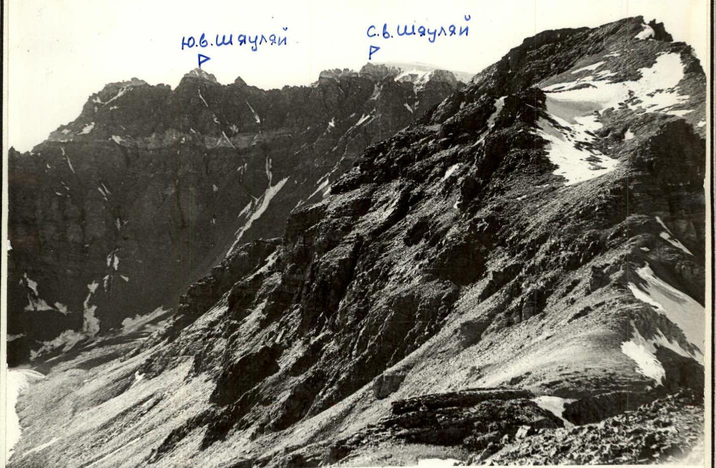
View of the summit from the southeast. Photo No. 4. Distance 2500 m. Lens "Industar-50-2", 3.5/50. August 16, 1984.