
Report
On the first ascent (variant) to peaks 5586 m and 5378 m (traverse) with ascent via the North-Eastern ridge (South-Western Pamir, Shahdara Range, Vakhan Range, Vnukut valley)
Group:
- Gudyalis A.V.
- Plyaskus Y.S., August 18, 1984
Coach: Gudyalis A.V. Committee for Physical Culture and Sports under the Council of Ministers of the Lithuanian SSR — 232675, Lithuanian SSR, Vilnius, Zhemaytes st., tel. 63-53-53.
Leader and coach: Gudyalis Algis Vitaoutovich, 232021, Lithuanian SSR, Kaunas, Kanyukų I-st, 4-17
- tel. w. 26-45-91
- w. 22-53-41
- 75-35-11
All heights mentioned in the report are taken from topographic maps.
BRIEF HISTORICAL AND GEOGRAPHICAL OVERVIEW OF THE REGION
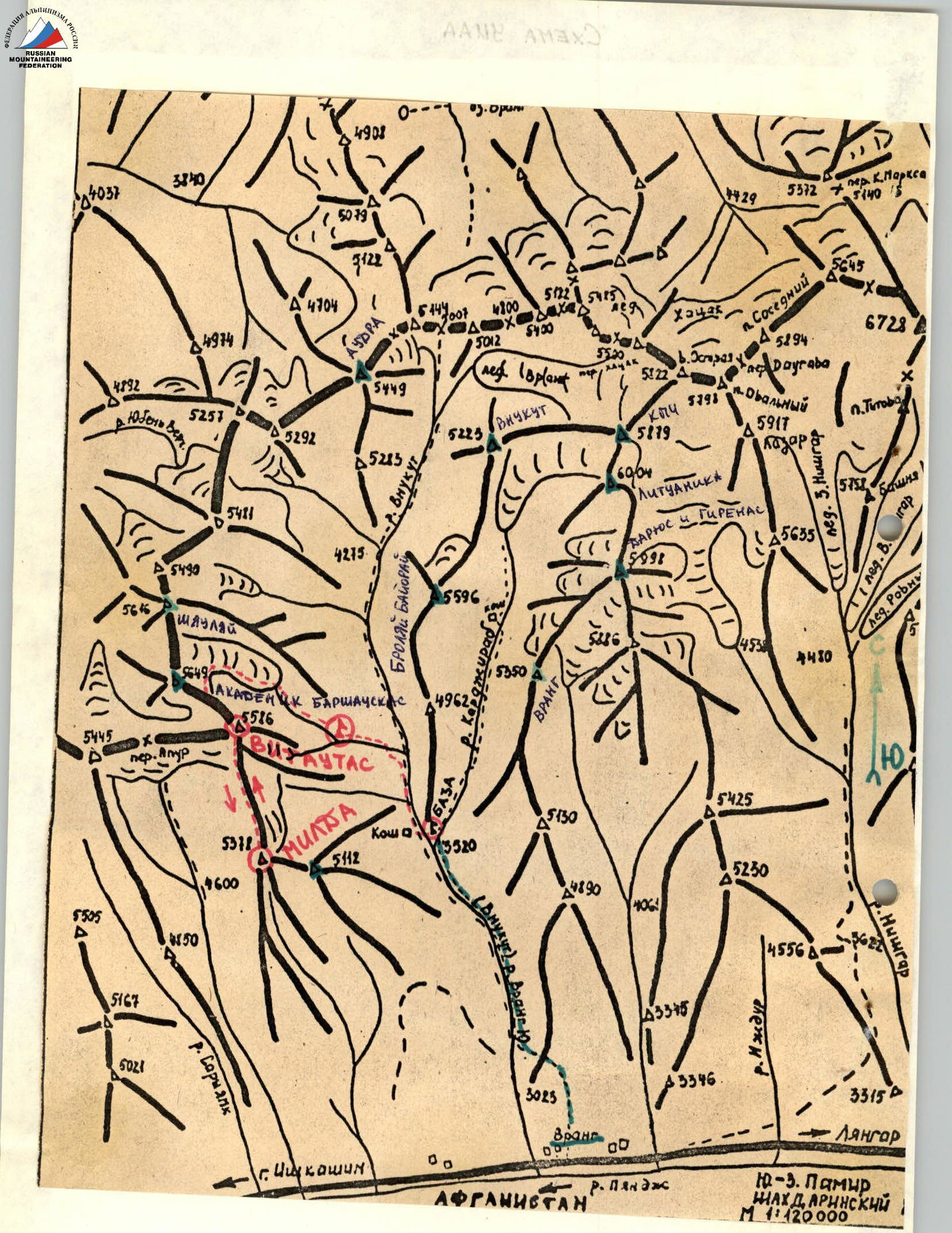
Peaks located in the South-Western Pamir, in the eastern part of the latitudinal segment of the Shahdara Range, specifically in the Vakhan Range:
- 5350 m (Vrang)
- 5998 m (Darius and Girėnas)
- 6004 m (Lietuvaitė)
- 5879 m (KPI)
- 5649 m (Academician Baršauskas)
The nearest regions explored by climbers are:
- the areas of p. Marx (6726 m) and Engels (6510 m) — to the east;
- the areas of peaks 6138 m (Armed Forces) and 6038 m (Baikonur) — to the west.
While traveling through the Pamir in 1904, B.A. Fedchenko explored and described the region of the Shahdara Range, located between the Shakhdara and Panj rivers.
Climbing exploration of the Shahdara Range began in 1946: in that year, Peak Karl Marx was conquered. In subsequent years, a number of expeditions were organized, mainly in the areas of Peaks Marx and Engels.
The central part of the Shahdara Range began to be explored in 1974, when the walls, later named p. Luknitsky, were accidentally noticed by V.P. Nekrasov.
In 1975, an expedition by the Armed Forces led by Nekrasov V.P., based at the Zardiv lake, conquered Peak 5800 m via a route of 5B cat. diff. along the NW ridge. This peak was named Luknitsky.
In subsequent years:
- military climbers, as well as other climbing expeditions, completed a number of interesting routes of 5B and 6B cat. diff. in this region,
- became prize-winners of the USSR Climbing Championship.
However, the part of the Shahdara Range between Peaks Dzhentivon and Marx remained unknown to climbers until 1983 and was only visited by a few groups of tourists.
Apparently, the reason for such late exploration of the region is that:
- These peaks are not visible from populated areas near the road
- High attendance of climbers in the areas of p. Engels, Marx, Luknitsky, Mayakovsky.
Preliminary reconnaissance of the Vakhan Range region (Yančung, Saryang, Vnukut, Čondžirav valleys) was carried out in 1983 by a reconnaissance group from the Sports Committee of the Lithuanian SSR (Gudyalis A.V. and Simutis R.Yu.). Photographic survey of the peaks of the Vakhan Range and visual examination of routes were conducted.
For climbers, the most attractive peaks are those that have not been climbed before. Especially if these peaks reach or exceed 6000 m in height.
In the summer of 1984, an expedition from the Sports Committee of the Lithuanian SSR led by Gudyalis A.V. arrived in the Vnukut valley with the aim of exploring this region from a climbing perspective, conquering previously unconquered peaks, and assigning them corresponding names.
The expedition established its base camp at the confluence of the Vnukut and Čondžirav rivers, at an altitude of 3520 m, approximately 3 hours' walk from the village of Vrang.
From an alpinism perspective, the region is very interesting for climbers from 2nd sports category to Candidate Master of Sports inclusive. There are many routes to the peaks ranging from 3A to 5B cat. diff., including:
- rock,
- combined,
- snow and ice.
Approaches to the routes take 3–8 hours from the base camp. Many first ascents are possible.
Rivers are turbulent. In the second half of the day — difficult to cross. Weather is generally stable, although in August 1984, a sharp cold snap, thunderstorms, and rains were observed for a week, as a result of which many ascents were not carried out.
The flora and fauna of the valley are not rich. Rarely encountered are:
- ephedra,
- Rhodiola rosea.
In the upper reaches of the Vnukut and Čondžirav rivers — pastures, summer nomadic encampments.
ROUTE DESCRIPTION
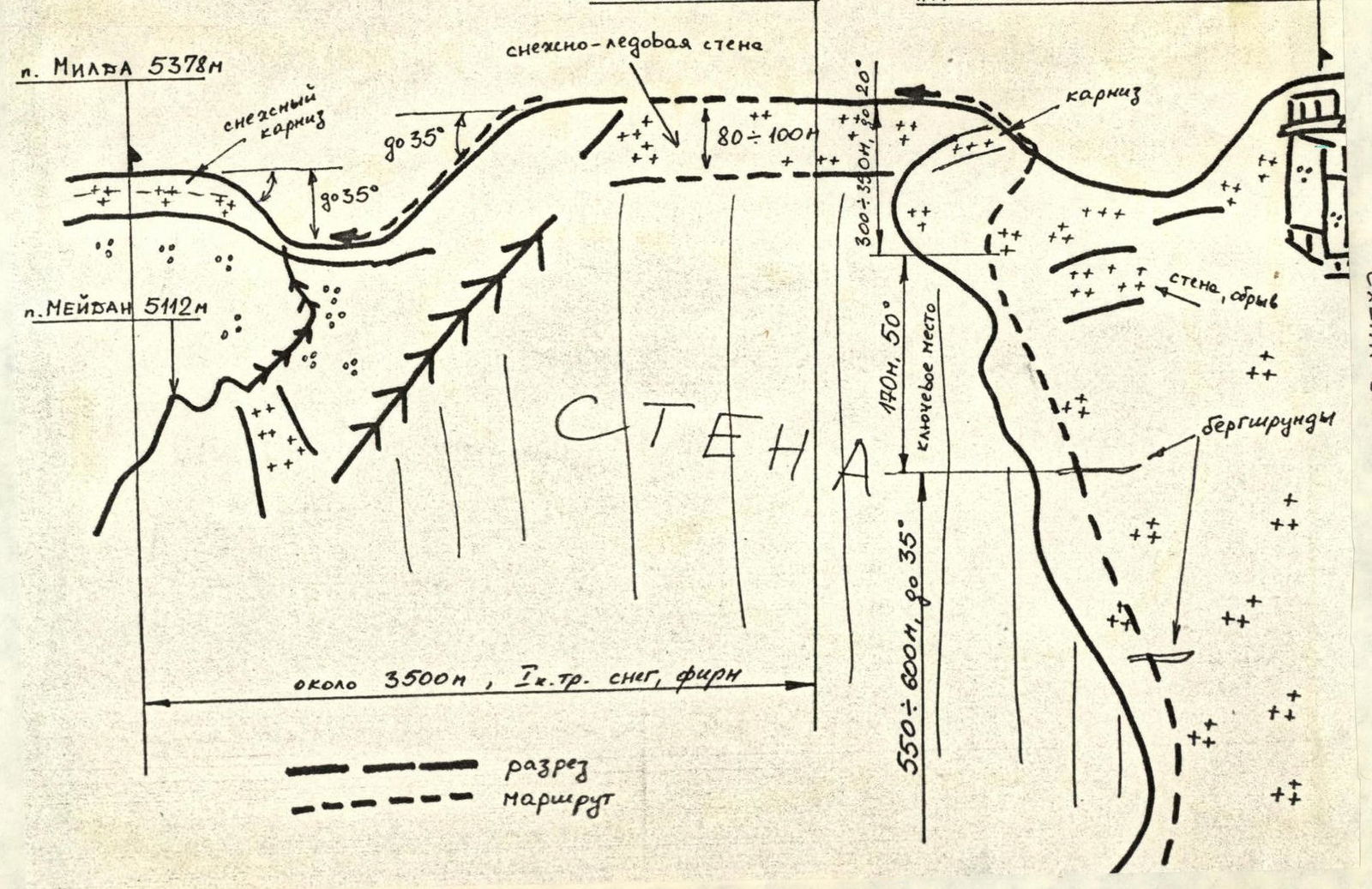
From the bivouac on the Edelweiss glade (4400 m), go to the glacier tongue (1–1.5 hours). Here, crampons are put on, as the ascent to the glacier reaches 20–25°. Along the glacier to the NE ridge of p. 5586 m — about 40 minutes. The ridge is a wide snow slope bounded on the left by a precipice and on the right by overhanging ice walls. Initially, for 500–600 m, the slope is not more than 30° steep. Simultaneous movement is possible, using ice screw protection. Further, after an ice crevasse (bergschrund), the steepness increases to 45–50°. This section, 170 m long, is traversed with alternating protection. After the steep section, the ridge continues for 300–350 m, with the steepness decreasing to 20° — exit slightly above the pass between p. 5586 m (Vytautas) and 5649 m (Academician Baršauskas). Here, turn left. To the summit along the plateau — another 800 m or so. There is no cairn on the summit, as it is a large snow plateau. This season, the route was traversed by three groups already, and instead of a cairn, a "snowman" was built. From the summit of 5586 m to the summit of 5378 m — across snow and ice for approximately 2500 m. Between the summits — a ridge with crevasses.
Descent via the ascent route takes about 2 hours. Total ascent time for a well-acclimatized group — 3–5 hours.
BRIEF OVERVIEW OF THE ASCENT REGION
Peaks 5586 m (Vytautas) and 5378 m are located in a lateral spur of the Shahdara Range between the Vnukut and Yamg valleys. The peaks are flat, long snowfields that drop off to the east with kilometer-long walls, while to the west, relatively gentle talus slopes descend. The height difference between p. 5586 m and 5378 m exceeds 200 m, and the distance between the peaks — 2500 m.
The approach to the start of the route — from the village of Vrang up the right bank of the Vnukut river to the Čondžirav tributary (about 3 hours). At the confluence of the rivers, cross to the left bank of the Vnukut (crossing in the second half of the day is dangerous!). Further, after about 1 hour's walk, turn left into a lateral valley without a name, towards the glacier cirque of peaks 5586 m, 5649 m, 5616 m. In the valley, overnight stays are possible on the Edelweiss glade at an altitude of 4400 m (2 hours' walk from the confluence of the Vnukut and Čondžirav rivers), or on the moraine at the glacier tongue (another 1.5 hours' walk). From both bivouac sites, the counterfort of p. 5586 m is very visible. A route of 5A cat. diff. can be laid along it.
TACTICAL ACTIONS OF THE TEAM
From the base camp at the confluence of the Vnukut and Čondžirav rivers, the group departed on August 15, 1984, at 14:00 and, after a 3-hour approach, spent the night at an altitude of 4400 m on the Edelweiss glade.
Prior to this ascent, on August 16, 1984, the participants completed first ascents:
- 4A cat. diff. to a peak with a height of 5600 m
- 3B cat. diff. to a peak with a height of 5600 m
and were in very good sporting form.
During these ascents, the route for the ascent to p. 5586 m and its traverse to p. 5378 m via the NE ridge was planned.
The ascent was made using crampons, ice axes, and ice screws with alternating lead. The descent was made via the ascent route, using special ice screws.