Ascent Passport
-
Category — high-altitude technical.
-
South-West Pamir, Nespár gorge.
-
Peak 5400 via the South-East wall of the East counterfort.
-
Proposed 5A category of complexity, first ascent.
-
Route height difference — 540 m, including 300 m of wall section. Route length — 740 m, sections with 5–6 category of complexity — 195 m. Average route slope — 50°, wall section — 75°.
-
Pitons driven:
rock placed pitons threaded ice 21 48/9
-
Climbing hours — 14 and days — 2.
-
Overnight stays: one in a lying tent under the wall after processing.
-
Leader — Karabash Vladimir Alekseevich — Master of Sports, «Kvant» sports club, Obninsk
Participants:
- Dvoryashin Alexander Mikhailovich — Candidate Master of Sports, «Kvant» sports club, Obninsk
- Koshcheev Vladimir Nikolaevich — Candidate Master of Sports, «Kvant» sports club, Obninsk
- Kuznetsov Andrey Viktorovich — Candidate Master of Sports, «Zenit» sports club, Kaluga
- Troyanov Vladimir Mikhailovich — Candidate Master of Sports, «Kvant» sports club, Obninsk
-
Coach — Chernov Lionel Aleksandrovich — Master of Sports, «Kvant» sports club, Obninsk.
-
Approach to the route — July 17, 1986.
Summit — July 18, 1986, return to base camp — July 19, 1986.
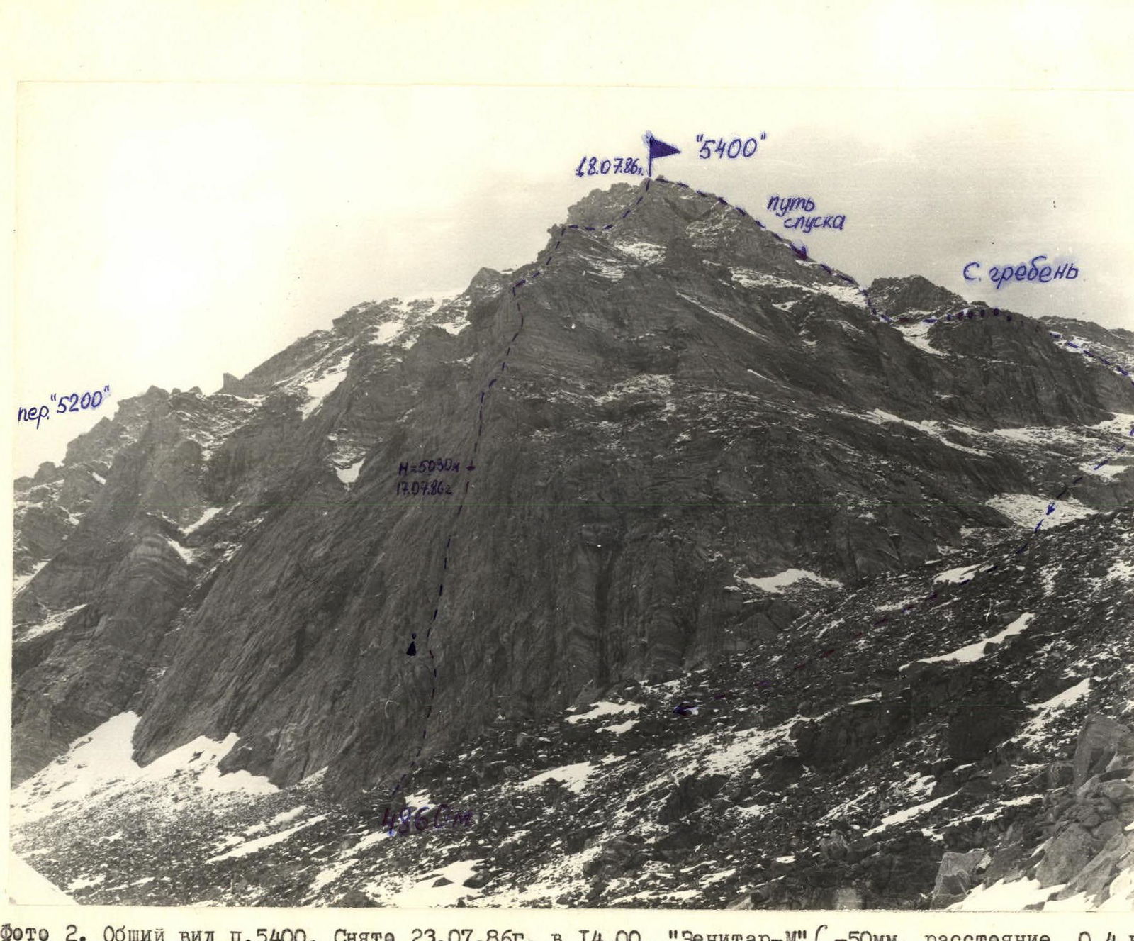
Photo 2. General view of Peak 5400. Taken on July 23, 1986 at 14:00. «Zenitar-M», f = 50 mm, distance 0.4 km, H = 4870 m. Shooting point #1.
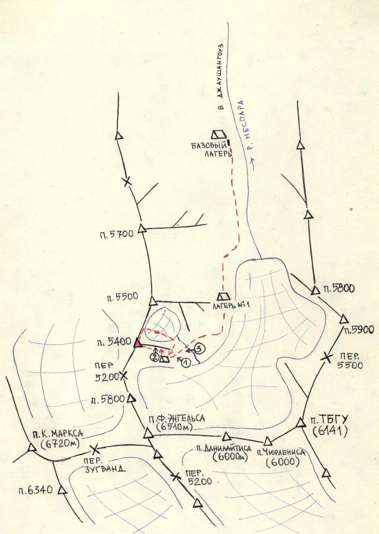
Fig. Schematic map of the ascent area (scale 1:50 000). — shooting points.
Brief Overview of the Climbing Area
From Peak Engels (South-West Pamir), a spur of the Shakhdara ridge branches off in the northern direction, dividing the Shaboí and Nespára gorges. In this spur, from south to north, there are peaks: Peak 5800, Peak 5400, Peak 5500, Peak 5800, and others. Peak 5400 is a triangular pyramid formed by the South, North ridges, and the East counterfort. The Western wall of Peak 5400 faces the Shaboí gorge. The North-East wall is heavily destroyed and rockfall-prone. The South-East wall of the East counterfort steeply drops into the Nespára glacier cirque, bounded from the south by Peak Engels, from the west — by Peak 5800 and Pass 5200. In its steepest part (average slope of the SE wall 75°), the wall is rich in relief: cornices, cracks, wells, chimneys, internal corners. The most safe and logical routes in this part of the wall are through a system of cracks 250–300 meters long, leading to the East counterfort. The counterfort is snowy in its upper part; here, on the way to the summit, there are rock walls of varying difficulty from III to V category, up to 40 meters long, ice sections, and couloirs.
To reach Peak 5400, one can follow the Népára river gorge. This gorge starts 7 kilometers from the village of Jaushangoz, located 40 kilometers from the town of Jilandy on the Osh — Khorog highway. Alternatively, one can reach Jaushangoz from Khorog via a local road (by hitchhiking), passing through the large village of Roshtkala (150 km), if the road from Jilandy to Jaushangoz is closed. A base camp in the Nespára gorge can be set up at a location accessible by a high-clearance vehicle (3 hours walking from the start of the gorge). From the base camp to an intermediate camp on the left-bank moraine of the Nespára glacier — 2.5 hours walking. From here, one can ascend Peak TBGU, Peak Engels. To reach Peak 5400, it takes 1.5 hours.
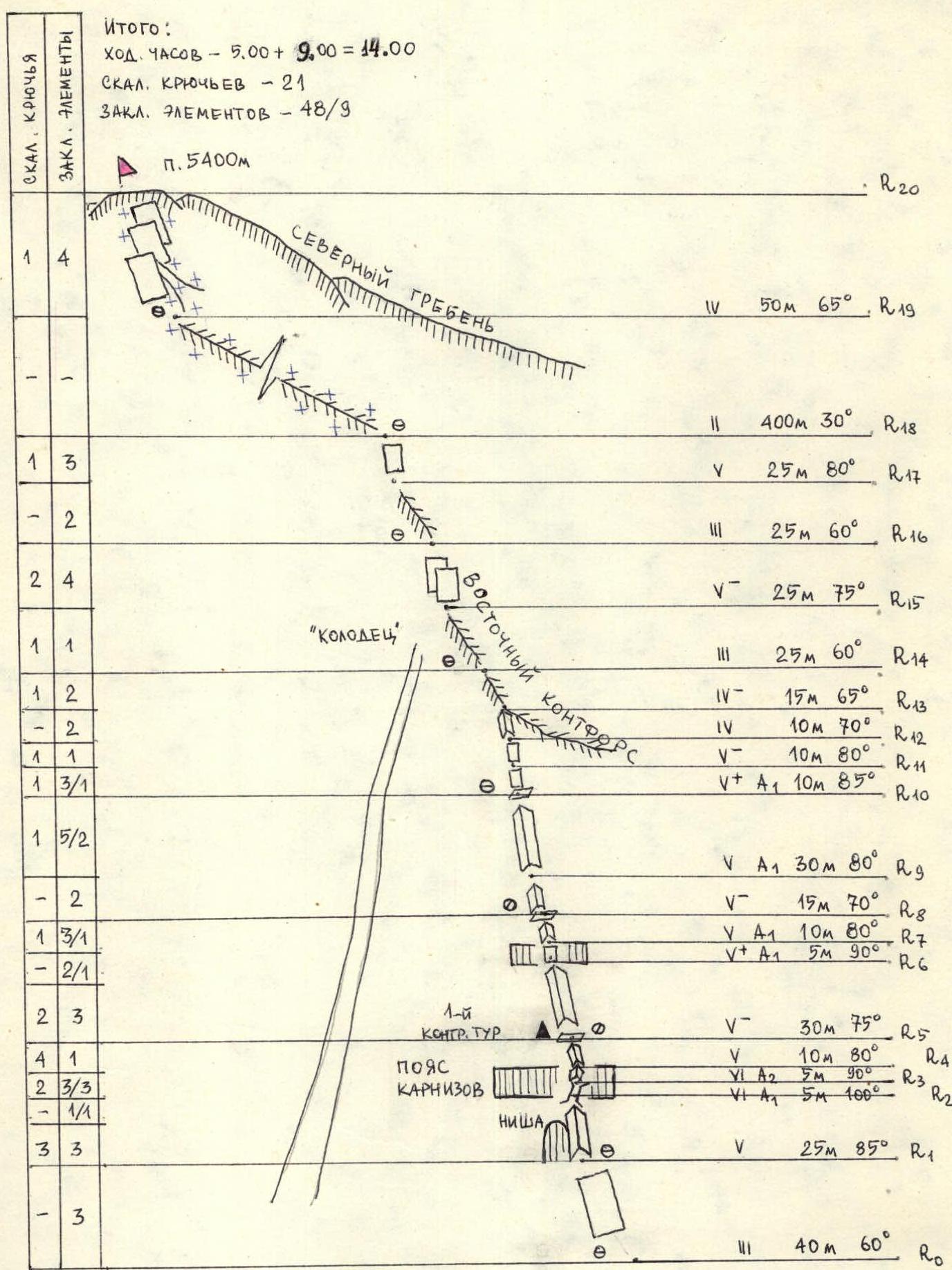
Fig. Route diagram on Peak 5400 via the SE wall in UIAA symbols (scale 1:4000).
Route Description by Sections. The most interesting part of the route is the wall section along the South-East wall of the East counterfort. Here, the route follows a system of cracks and internal corners. A characteristic feature of the route's start is a niche under a cornice, from which three cracks radiate. The right crack passes through the entire wall and leads to the counterfort.
Section R0–R1. Does not present technical difficulties.
Section R1–R2. An implicitly expressed internal corner leading under a cornice, encircling the system of cracks. There are cracks for reliable belays. Direction of movement — towards a characteristic spall in the cornice.
Section R2–R3. Passage through the cornice via a chimney to the right of the spall, transitioning into an internal corner. Climbing is extremely difficult. Used a friend for ITO (Intermediate Technical Object).
Section R3–R4. Steep internal corner, extremely difficult for climbing. Used chocks and friends for ITO.
Section R4–R5. Internal corner leads to a small ledge, where a control cairn was hung on a piton. Here ends the key section of the route.
Section R5–R6. Internal corner with rich relief leads under the second cornice on the route.
Section R6–R8. The cornice is overcome by a wall of the internal corner and then by an internal corner onto a small platform.
Sections R8–R14. Two ropes (45 m each) of climbing, category V complexity, through an internal corner-crack with rich relief. Some placements used chockstones for ITO. Here ends the wall part of the route; it continues along the East counterfort.
Sections R14–R20. The route follows the counterfort, where walls up to 20–25 meters of category V complexity are encountered. In the gentler part, the counterfort is snowy, with ice under the snow.
Descent:
First along the North ridge, then down to the right along a snowy, scree-filled couloir.
From the summit to the bivouac under the wall — 1–1.5 hours.
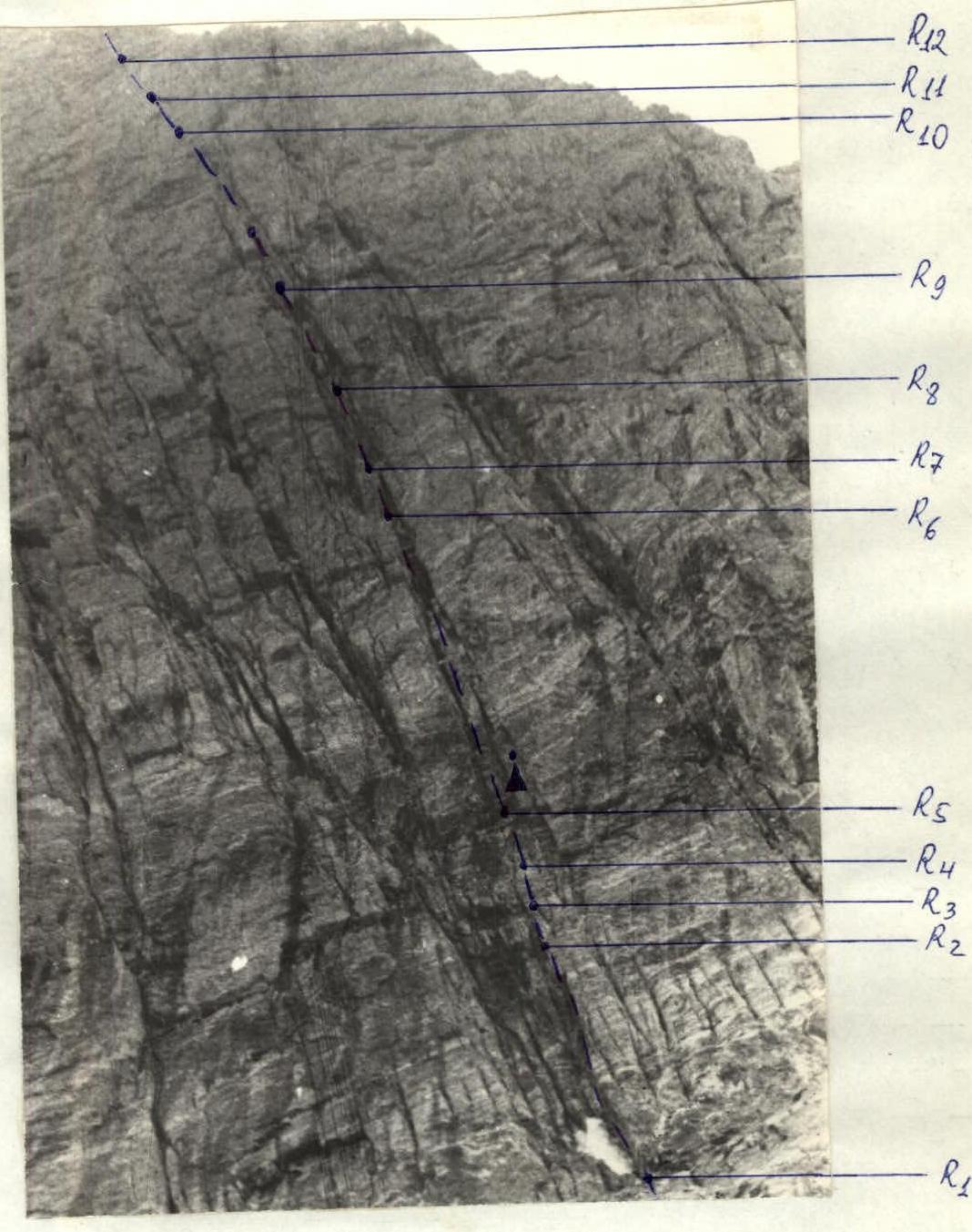
Photo 3. Technical photograph of the wall section of the route. Taken on July 16, 1986 at 14:30. «Industar-50-2», f = 50 mm. Distance 150 m, H = 4860 m. Shooting point #2.
Protocol of the Ascent Review on Peak 5400, July 17–19, 1986, led by Karabash V. A.
Present: senior coach of the gathering, releasing Master of Sports Chernov L. A., head of the rescue team of the gathering Tivartchuk V. F., group members Karabash V. A., Dvoryashin A. M., Koshcheev V. N., Kuznetsov A. V., Troyanov V. M. Ascent leader Karabash: the objective was chosen for preparation for the RSFSR Championship, as the Budanov route on Peak Engels could not be taken due to bad weather, avalanche danger, and the route's challenging condition. Peak 5400 is 1100 meters lower than the dominant Peak Engels above the gorge; the route has a south-eastern exposure, allowing for «windows» in daily bad weather, waiting 1–2 hours for the snow on the rocks to thaw, and passing the route under these conditions with preliminary processing. The 205-meter wall section allowed the team to practice with extensive use of rock climbing techniques and improve group interaction. They approached the route on July 17 at 10:00, waited out the bad weather, refined the ascent path, and after the rocks dried a bit (there was little snow on steep areas, only in cracks, internal corners, and on ledges), started processing at 12:00. By 17:00, they processed 3 ropes (45 meters each), adjusted the hung ropes, and began descending (Troyanov, Koshcheev). The weather turned bad again, with wet snow. They spent the night on a platform under the route. The next morning, the weather was bad, with no visibility. By 8:30, it cleared a bit; at 9:00, they ascended via the hung ropes. They climbed another 70 meters along the wall, reached the counterfort, and ascended to the summit at 18:00. They built a cairn. They began their descent at 18:15 (it had been snowing since 16:00), were under the route by 19:15, had a snack, contacted base, and descended to the intermediate camp on the moraine of the glacier under the NE wall of Peak Engels by 21:00. The next morning, they arrived at the base camp. The route was completed in 14 climbing hours, including processing. They drove 21 rock pitons, placed 42 chocks, and 6 friends. Three participants worked as lead climbers — Troyanov, Koshcheev, Dvoryashin. Interaction was well-organized. Remarks: when passing cornices on ropes, one should immediately use a stirrup for foot support; some wasted strength and time passing here on hands. Overall, they worked and trained well. The route is logical; the wall section is interesting, with extremely difficult areas in the lower part of the wall. Proposed 5A category of complexity because:
- the wall section is too short for 5B;
- the route is more complex than 5B on Peak Litva;
- clearly more complex than 5A on Peak Passionaria via the bastion and 5A on Peak Babel. Participants are ready for a category 6 ascent for the RSFSR Championship.
Troyanov V. M.: despite snowmelt, wet rocks, no rocks were dislodged; during processing and passage on ropes, not a single rock was dislodged. The route is very interesting; passing the lower part of the wall requires maximum tension. It is characteristic that there are few places for piton placement, but there is a possibility to use chocks and friends.
Chernov L. A.: by the coaching council's decision, the route is preliminarily classified as 5A category of complexity. The ascent and leadership are to be counted for the group.
Protocol recorded by: V. N. Koshcheev