
ASCENT DOCUMENT
- Ascent category — technical.
- Ascent area — South-Western Pamir, Shahdara Range, Darshai valley.
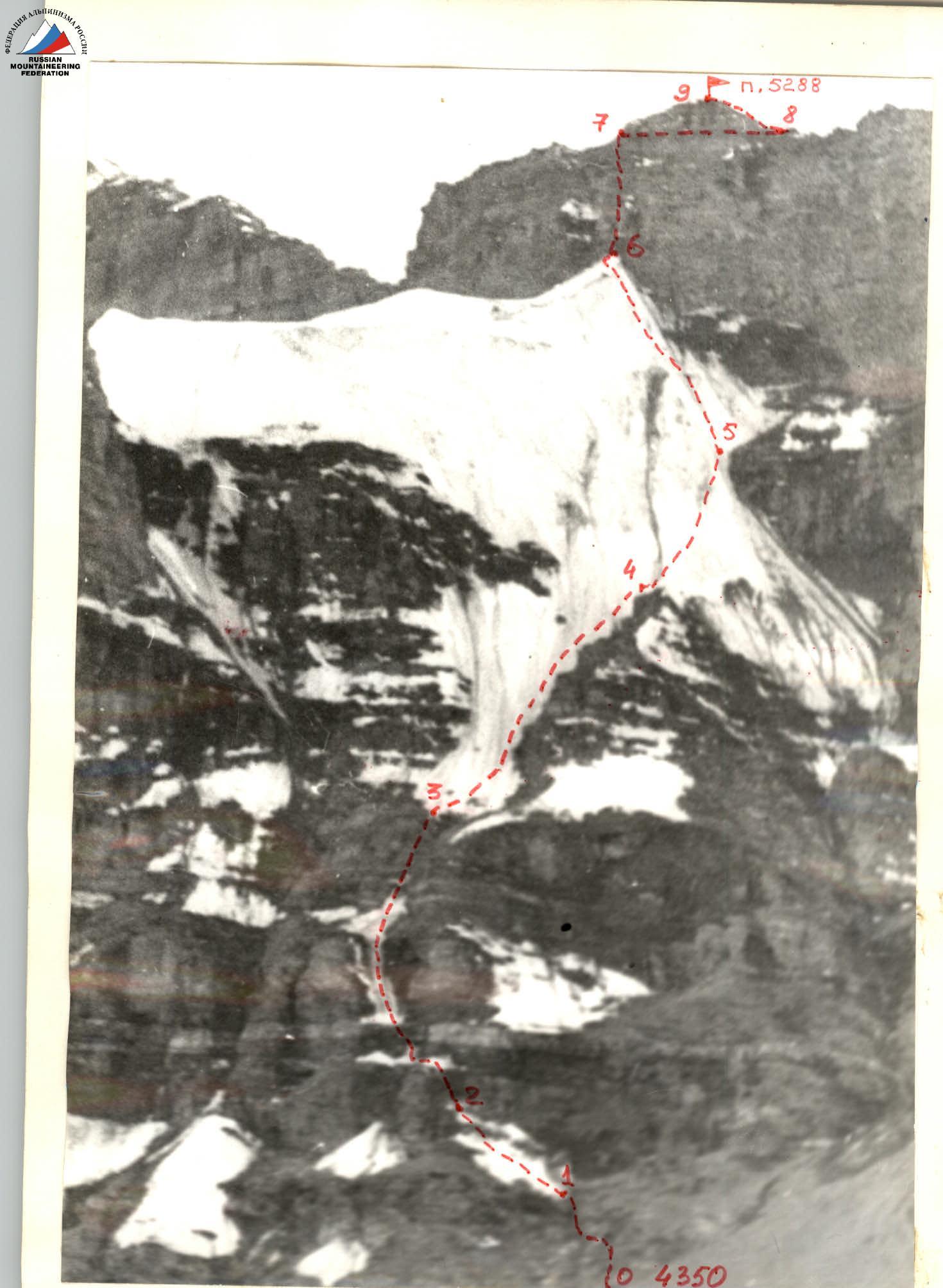
- Peak, its height, ascent route — p. 5288 (proposed name — Peak Academician Ivanov V.E.), via the North face of the Eastern counterfort.
- Proposed category of difficulty — 5A, first ascent.
- Height difference from the base of the wall — 938 m.
- Average steepness — 65°.
- Total route length — 1480 m.
- Length of sections with 5–6 category of difficulty — 870 m.
- Pitons hammered: rock — 35, ice — 89, total — 124.
- Total hours on the route — 14 h.
- Number of nights on the route — 0.
- Team members:
- Samoded Alexey Anatolyevich — Master of Sports,
- Lebedev Anatoly Borisovich — 1st category.
- Team coach — Poberezovsky Vladimir Iosifovich.
- Date of departure for the route — August 2, 1982. Date of return — August 2, 1982.
BRIEF DESCRIPTION OF THE APPROACH TO THE ROUTE
The object of the first ascent (p. 5288) is located in the Darshai river valley (local name — Darai-Darshai), which is a right tributary of the Panj River. At the confluence with Panj, there is a village Darshai, accessible by car (approximately 200 km from Khorog city).
The base camp of the expedition was set up 2 km upstream from the confluence of the Imast river into Darshai (25 km from Darshai village), at the summer pasture Kapa.
The path to the route from the base camp follows a trail along the left (in the direction of travel) bank of the Darshai river, upstream. The ascent object is located above the point where the river bends 90° to the left. At this bend, there is a summer pasture Hanuk. 2 km before reaching Hanuk (approximately 12 km from the base camp; the trail here begins to wind among large boulders), one should turn left. From here, the North face of the Eastern counterfort of p. 5288 comes into view. Ascend leftwards, first through grassy, then scree slopes, to the base of the route.
It is convenient to camp near a stream flowing from the rightmost snowfield on the steep scree under the wall's base.
The approach from the base camp to the campsite under the route takes 5 hours.
The observation group was stationed near the Hanuk summer pasture, from where the entire route is clearly visible.
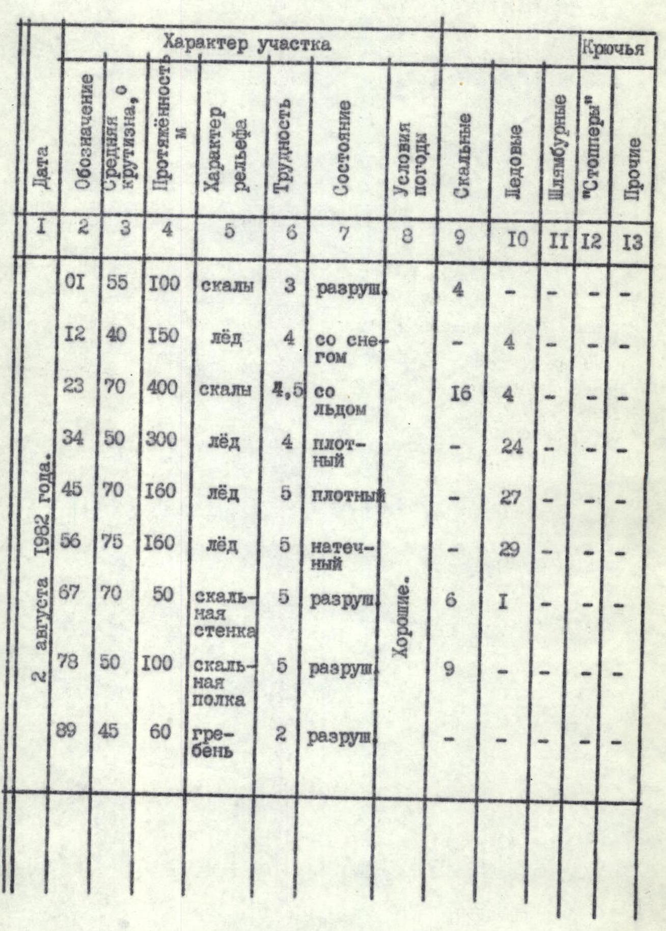
TABLE OF MAIN CHARACTERISTICS OF THE ASCENT ROUTE
| Designation | Average steepness, ° | Length, m | Terrain type | Difficulty | Condition | Weather | Rock pitons | Ice pitons |
|---|---|---|---|---|---|---|---|---|
| R0–R1 | 55 | 100 | rocks | 3 | broken | Good | 4 | – |
| R1–R2 | 40 | 150 | ice | 4 | with snow | Good | – | 4 |
| R2–R3 | 70 | 400 | rocks | 4,5 | with ice | Good | 16 | 4 |
| R3–R4 | 50 | 300 | ice | 4 | dense | Good | – | 24 |
| R4–R5 | 70 | 160 | ice | 5 | dense | Good | – | 27 |
| R5–R6 | 75 | 160 | ice | 5 | serac | Good | – | 29 |
| R6–R7 | 70 | 50 | rock wall | 5 | broken | Good | 6 | 1 |
| R7–R8 | 50 | 100 | rock ledge | 5 | broken | Good | 9 | – |
| R8–R9 | 45 | 60 | ridge | 2 | broken | Good | – | – |
August 2, 1982.
BRIEF EXPLANATION OF THE TABLE OF MAIN CHARACTERISTICS OF THE ASCENT ROUTE
After preliminary observation of the wall, an objectively safe variant of the first ascent route on p. 5288 was chosen. The route passes through the central part of the North face of the Eastern counterfort. A logical and straightforward descent from p. 5288 was observed from p. 5612 during a training ascent.
On August 1, 1982, the group arrived under the route and set up a bivouac at the base of the wall. From here, additional observations of the wall and rockfall hazards were made.
On August 2, at 22:09, the group started the ascent. The early start aimed to increase safety on rockfall-prone and icy sections. Sections R0–R1, R1–R2, R2–R3 were traversed in the dark with headlamps. The movement on the route was as follows.
Section R0–R1. Ascend moderately steep rocks to the right, towards a passage between two rock formations. The passage leads to a steep, broken couloir. Exit to a wide ledge on the right side of the couloir. Then, alternate between several ledges and small (2–3 m) walls of moderate steepness. Navigate towards a large ice field above to the left. At the lower part of the field, on its right side, there is a spacious platform where crampons can be put on. The section is 100 m long, 4 rock pitons were hammered, and it took 30 minutes to complete.
Section R1–R2. Move straight up the ice (steepness from 30° to 50°) towards a rock couloir at the upper part of the ice section. Traverse this section in crampons. The ice is covered with snow in many places, with a hard serac layer beneath a thin snow layer. The section is 150 m long, 4 ice screws were placed, and it took 30 minutes to complete.
Section R2–R3. The section begins with an icy rock couloir (65°). Ascend 40 m up the couloir to where the steepness increases sharply. Then, move rightwards onto a broken wall (60°–70°) with many holds. Ascend the wall 20 m to a sloping ledge covered with ice. Traverse left 15–20 m along the ledge. Then, alternate between steep rock and ice sections for about 200 m until reaching a wide (15 m, 45°) snow-ice ledge. To overcome these 200 m, frequent removal and putting on of crampons is required, which is challenging on such terrain and slows down the movement. After passing the ice ledge, ascend steep (70°–80°) rocks for about 100–110 m until reaching the ice (the lower, less steep part of the ice wall).
The section took 2 hours 30 minutes to complete. Its total length is 400 m.
16 rock pitons were hammered, and 4 ice screws were placed.
Section R3–R4. The first 100 m of the section are on a wide, not very steep (30°–40°) ice field. Then, the field narrows to a 60-meter-wide ice strip leading upwards. The slope increases, and many small gullies appear in the ice, merging into one large gully (2 m deep, 4 m wide) near the right edge of the strip. Cross to the right side of the gully and move between it and the rock edge. After 150 m (4 incomplete ropes), the couloir becomes less pronounced, funnel-shaped, and the entire ice strip becomes concave. Still on the right side, move until a small shoulder divides the flowing ice mass into two. Before reaching the shoulder, the steepness reaches 60°.
The section took 2 hours to complete. Its total length is 300 m.
24 ice screws were placed.
Section R4–R5. The first 40 m involve movement along the shoulder. Then, the shoulder steepens. Movement becomes challenging due to sharp, hard, but brittle ice formations. From here, move rightwards and upwards for 120 m. This section and the next represent the most challenging part of the route — the ice wall. The ice steepness reaches 80° at times, requiring strenuous physical effort. It's preferable for the first climber to work without a backpack. Towards the end of the section, the ice becomes purely serac, making it harder to place ice screws. The end of the section corresponds to a slight change in the azimuthal orientation of the wall (from left to right) and the closest proximity to the route of the lower edge of the ice-covered rock ledge (on the right). The section took 3 hours to complete. Its total length is 160 m. 27 ice screws were placed.
Section R5–R6. This section consists of 160 m of 75° ice with a serac structure. It took an hour to overcome each rope length — 4 hours total. 29 ice screws were placed. The section ends with a 1.5-meter cornice on the Eastern ridge of the summit.
Section R6–R7. Approach the wall of the summit tower along the ridge. The wall is quite steep (70°) and very broken, requiring careful passage and attention. One rope length from the start of the wall, there is a scree ledge convenient for setting up belay. The section took 30 minutes to complete, 6 rock pitons and 1 ice piton (under the wall on the ridge) were hammered. The total length of the section is 50 m.
Section R7–R8. From the ledge under the overhanging rocks, traverse rightwards. Exit onto a less pronounced ledge that wraps around the summit tower. Move along it until reaching the North-West ridge of the summit.
- The section took 45 minutes to complete.
- 9 rock pitons were hammered.
- The total length is 100 m.
Section R8–R9. Move along a straightforward, broken ridge for 60 m until reaching the summit of p. 5288. The rope is secured to rock formations. The ascent took 15 minutes.
A control cairn with a note from the first ascenders was left on the summit. Intermediate control cairns were not made due to the lack of a suitable location.
The descent is made in a southerly direction through scree, easy broken rocks, and 'ram's foreheads' into the moraine cirque formed by peaks 5612, 5605, 5455, 5288, and from there, into the Darshai river valley. The journey from the summit to the Hanuk summer pasture takes 2–3 hours.
ADDITIONAL INFORMATION ABOUT THE ASCENT
- Reconnaissance of the approach to the route, photography, and observation of the ascent object were carried out by participants of the alpinist expedition of the Kharkov Regional Sports Committee in 1974, as well as in 1979 by participants of tourist treks of the 5th category of difficulty (Kharkov city, HIRE tourist club). These preliminary data allowed for advance planning of the ascent on p. 5288.
- The condition of the route and weather conditions during the ascent were favorable (absence of freshly fallen snow); however, the severe brokenness of the rock sections and the associated potential rockfall hazard complicated and slowed down their passage.
- During the ascent, 12-tooth crampons, ice axes, and ice screws were used on the ice sections. All this ice equipment was carefully selected for the ascent and tested during a training ascent.
- The ascent was observed by a group of 2 people:
- Samsonova L.N. — 2nd category
- Tirko I.V. — 2nd category
The group observed from the Hanuk summer pasture. 5. For organizing belay points on the rock terrain of the route, it is advisable to use thick and wedge-shaped rock pitons, as wide cracks prevail. 6. The total weight taken on the ascent: - food — 3 kg - shared equipment — 12.4 kg.
CONCLUSION ABOUT THE ROUTE AND RECOMMENDATIONS
The route passed is technically challenging. It is characterized by a large volume of ice work. To complete it, experience in overcoming steep ice sections with ice axes and crampons is necessary.
Besides technical skill, participants will require good physical and psychological preparation, as the extent of ice and the lack of convenient places for camping on the route demand a high pace of movement.
The ice nature of the terrain, combined with rock sections, classifies the route as combined.
It is also characteristic that the wall has a North-facing exposure and remains in shadow for most of the daylight hours.
The most favorable time for ascending this route is from mid-June to mid-August.
For the route, bivouac equipment is necessary: down sleeping bags and jackets, a stove, a tent — in case of a forced night on the route.
The rock structure is granite with marble inclusions, heavily broken.
The group members had good ice preparation and experience in similar ascents. They had completed a training ascent on an ice route of 3B category on p. 5612 in the same composition for:
- acclimatization;
- practicing ways to overcome steep ice sections.
Future climbers on this route are recommended to pay great attention to preparation and careful selection of equipment:
- crampons
- axes
- ice axes
- pitons
- etc.
It is recommended to choose an ascent tactic similar to that of the first ascenders, who completed the ascent in one day.