Passport
I. Altitude class
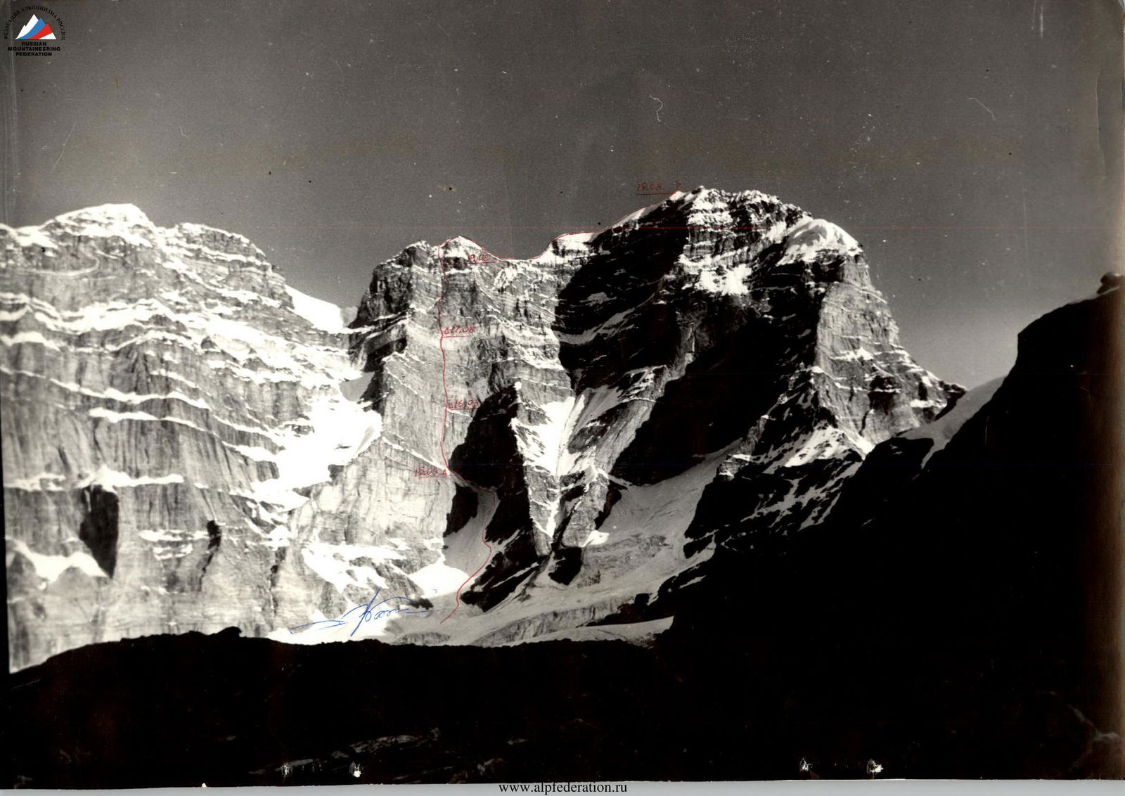
- South-Western Pamir, Kish-ty-Dzhërob gorge
- Peak Engels 6510 via the "well" on the South face.
- Proposed - 6B category of difficulty, first ascent.
- Height difference 1160 m, length - 2382 m.
- Length of sections with 5-6 category of difficulty - 732 m.
Average steepness of the main part of the route - 75°, including 6B category of difficulty - 84°.
-
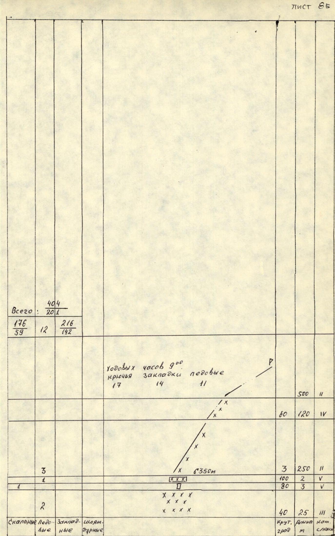
Pitons driven: Rock: 176, bolt: 59, chocks: 216, ice: 12. At the bivouac: 2 bolt, 142 chocks.
-
Team's total climbing hours: 61 h 30 min, 5 days.
-
Bivouacs: R1-R2-R4 - a platform carved on a snow-ice shelf, 8 people; R3 - a tent on a platform for 4 people, four - sitting on a shelf.
-
Team leader: Vladimir Sergeyevich Balyberdin, Master of Sports of International Class
Team members:
- Yury Mikhailovich Razumov, Master of Sports
- Nikolay Borisovich Shustrov, Candidate for Master of Sports
- Alexey Borisovich Shustrov, Candidate for Master of Sports
- Yevgeny Yevgenyevich Mayorov, Candidate for Master of Sports
- Georgy Grigoryevich Kotov, Candidate for Master of Sports
- Yury Yevgenyevich Pozhidaev, Candidate for Master of Sports
- Vladimir Dmitriyevich Petrikov, Candidate for Master of Sports
Coach: Konstantin Borisovich Kletsko, Honored Coach of the RSFSR
- Departure to the route: August 15, 1986. Reached the summit: August 19. Return: August 20.
Departure from base camp on August 14 at 14:00. Overnight under the route at an altitude of 5200 m.
Tactical actions of the team
-
August 15, 1986
- Departure from bivouac at 7:30, on the route at 8:30.
- The first rope team reached the planned bivouac at 12:00 and started processing the rocky part of the route at 13:00.
- Mayorov worked first, Balyberdin belayed.
- The rest of the participants prepared lunch and places for tents as they arrived.
- At 18:00, the first rope team descended to the bivouac, N. Shustrov and G. Kotov went to process the route and descended by 21:30.
- In total, about 80 m of 6th category of difficulty rock was processed on the first day.
-
August 16, 1986
- At 8:30, the ascent via fixed ropes and further route-finding began with the rope team Mayorov - Balyberdin.
- The rest of the group started moving after an hour and a half.
- The group reached the planned bivouac at 18:00.
- The rope team Balyberdin - A. Shustrov worked on the route until 21:30 and fixed 40 m of ropes.
-
August 17, 1986
- At 7:00, the leading rope team N. Shustrov - A. Shustrov started moving via the fixed ropes.
- The rope team Balyberdin - Mayorov ascended afterwards to straighten the path and transfer equipment.
- The rest of the participants started moving at 12:00.
- At 18:00, the participants of the first rope team swapped places, and by 19:30, the first one reached the bivouac site in the middle of the quartz belt.
- By 20:30, the rest of the participants caught up.
- A tent-platform for 4 people was set up, the rest settled sitting on a shelf.
- On August 16 and 17, Yu. Razumov led the work at the end of the group.
-
August 18, 1986
- At 8:30, the rope team Kotov - Balyberdin started working on the route.
- By 18:00, 6 ropes were passed, after which Kotov was replaced as the leader by Mayorov.
- Three ropes later, the first one reached the planned bivouac on a snow cushion.
- By 21:30, the group gathered together and quickly prepared a site for two tents.
-
August 19, 1986
- At 9:00, the rope team Balyberdin - Razumov started working.
- At 12:00, when passing a snow-ice slope, Mayorov took the lead.
- By 15:00, the whole group ascended to the main ridge.
- At this time, the first participants prepared tea, and after a light lunch, the group moved up along the southern ridge at 16:00.
- The rope team Kotov - Balyberdin led the way.
- At 18:00, the participants reached the summit and started descending at 18:30.
- At 21:00, the group bivouacked on a plateau below the southern col of the massif, on a 5A category of difficulty route.
-
August 20, 1986
- At 9:00, the group continued descending along the Western ridge to the Zugvand glacier and further through the 5200 pass, reaching the base camp by 21:00.
Conclusion
The main idea of the tactical plan was:
- Maximum utilization of daylight by changing two or three leading rope teams during the working day.
- Having at least five strong lead climbers in the group allowed:
- Maintaining a high speed of route passage.
- Avoiding overloading any of the participants.
Route diagram in symbols
Sheet 85, part 1
| K1 | K2 | Steepness (°) | Length (m) | Cat. diff. | Section № | ||
|---|---|---|---|---|---|---|---|
| 2 | 1 | 30 | 20 | 3 | 39 | ||
| 3 | 3 | 80 | 5 | 5 | 28 | ||
| 2 | 3 | 90 | 15 | 6 | 27 | ||
| 2 | 2 | 70 | 15 | 5 | 26 | ||
| 3 | 30 | 10 | 3 | 25 | |||
| 5 | 80 | 25 | 6 | 24 | |||
| 8 | 1 | 70 | 45 | 5 | 23 | ||
| 2 | 80 | 10 | 6 | 22 | |||
| 2 | 1 | 80 | 10 | 5 | 21 | ||
| 2 | 20 | ||||||
| 2 | 25 | CONTROL CAIRN | 100 | 30 | 6 | ||
| 2/3 | 180 | 8 | 6 | ||||
| 6 | 25 | 100 | 30 | 6 | |||
| 4/3 | 2/2 | 180 | 3 | 6 | |||
| 3/3 | 2/1 | 90 | 8 | 6 | |||
| 5 | 8 | 16.08 | 8 | 14 | |||
| 3 | 5 | 38,50 m | 15 | 13 | |||
| 2/3 | 3/2 | 160 | 8 | 6 | |||
| 6 | 8 | 80 | 15 | 6 | |||
| 8 | 2 | 60 | 25 | 5 | |||
| 1 | 1 | 90 | 10 | 5 | |||
| 10 | 18 | ||||||
| 6 | 18 | 30 | 25 | 6 | |||
| 1 | 6 | ||||||
| 1 | 15 | 7 | |||||
| 1 | 15 | 95 | 22 | 6 | |||
| 1 | 1 | 80 | 8 | 4 | |||
| 2/2 | 1/3 | 70 | 7 | 4 | |||
| 20 | 30 | 80 | 6 | 6 | |||
| 15 | 26 | ||||||
| 3 | |||||||
| 5 | 3 | 90 | 30 | 6 | |||
| 16.08 | |||||||
| 38,50 m | |||||||
| ExaPn- | 40 | 600 | 3 | 0 | |||
| Hble | Steep. | Length | Cat. | ||||
| deg | m | diff. |
Sheet 85, part 2
| K1 | K2 | Steepness (°) | Length (m) | Cat. diff. | Section № | ||
|---|---|---|---|---|---|---|---|
| 4 | 2 | 45 | 60 | 3 | 53 | ||
| 2 | 3 | 90 | 20 | 5 | 52 | ||
| 3 | 3 | 10 | 51 | ||||
| 4 | 6 | 95 | 30 | 6 | 50 | ||
| 2 | |||||||
| 40 | 10 | 5 | |||||
| 90 | 5 | 6 | 47 | ||||
| 10 | 13 | ||||||
| 30 | 100 | 5 | 46 | ||||
| 5 | 5 | ||||||
| 70 | 40 | 5 | 45 | ||||
| 7 | 3 | ||||||
| 80 | 40 | 5 | 44 | ||||
| 1 | 2 | 90 | 15 | 6 | 43 | ||
| 10 | |||||||
| 60 | 40 | 4 | 42 | ||||
| 4 | 1 | 60 | 25 | 5 | 41 | ||
| 1/1 | 90 | 5 | 5 | 40 | |||
| 3 | 30 | 15 | 4 | 39 | |||
| 80 | 3 | 5 | 38 | ||||
| 3 | 2 | 130 | 2 | 6 | 36 | ||
| 8 | 17 | ||||||
| 8 | 17 | 100 | 25 | 6 | 35 | ||
| 3 | 70 | 5 | 4 | 34 | |||
| 1 | 85 | 6 | 6 | 33 | |||
| 1 | |||||||
| 7 | |||||||
| 2 | Climbing hours 13.5. | 75 | 10 | 5 | 31 | ||
| Pitons 43 Chocks 67 | |||||||
| bolt 13 48 | |||||||
| Steep. | Length | Cat. | |||||
| deg | m | diff. |
Sheet 85, part 3
| K1 | K2 | Steepness (°) | Length (m) | Cat. diff. | Section № | ||
|---|---|---|---|---|---|---|---|
| Total: 404 pitons, 201 chocks | 60 | ||||||
| 176 | 216 | ||||||
| 59 | 142 | ||||||
| 12 | |||||||
| 500 | 2 | 59 | |||||
| 60 | 120 | 4 | 58 | ||||
| 3 | 250 | 2 | 57 | ||||
| 100 | 2 | 5 | 56 | ||||
| 80 | 3 | 5 | 55 | ||||
| 40 | 25 | 4 | 54 | ||||
| Steep. | Length | Cat. | |||||
| deg | m | diff. |

Route diagram in symbols
Route diagram in symbols
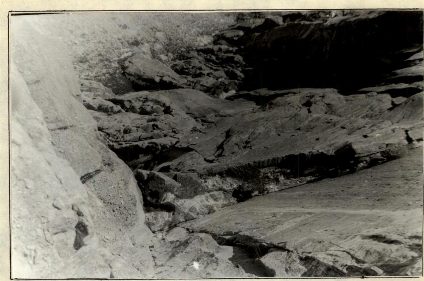
View from above of the R8-R9 section, 6th category of difficulty.
Section R11-R13, 6th category of difficulty.
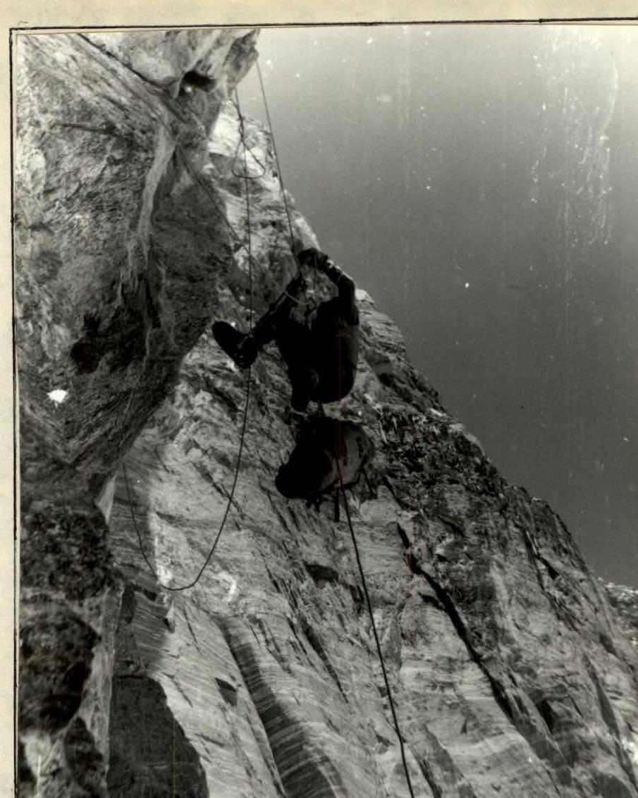
Section R12-R13, 6th category of difficulty.
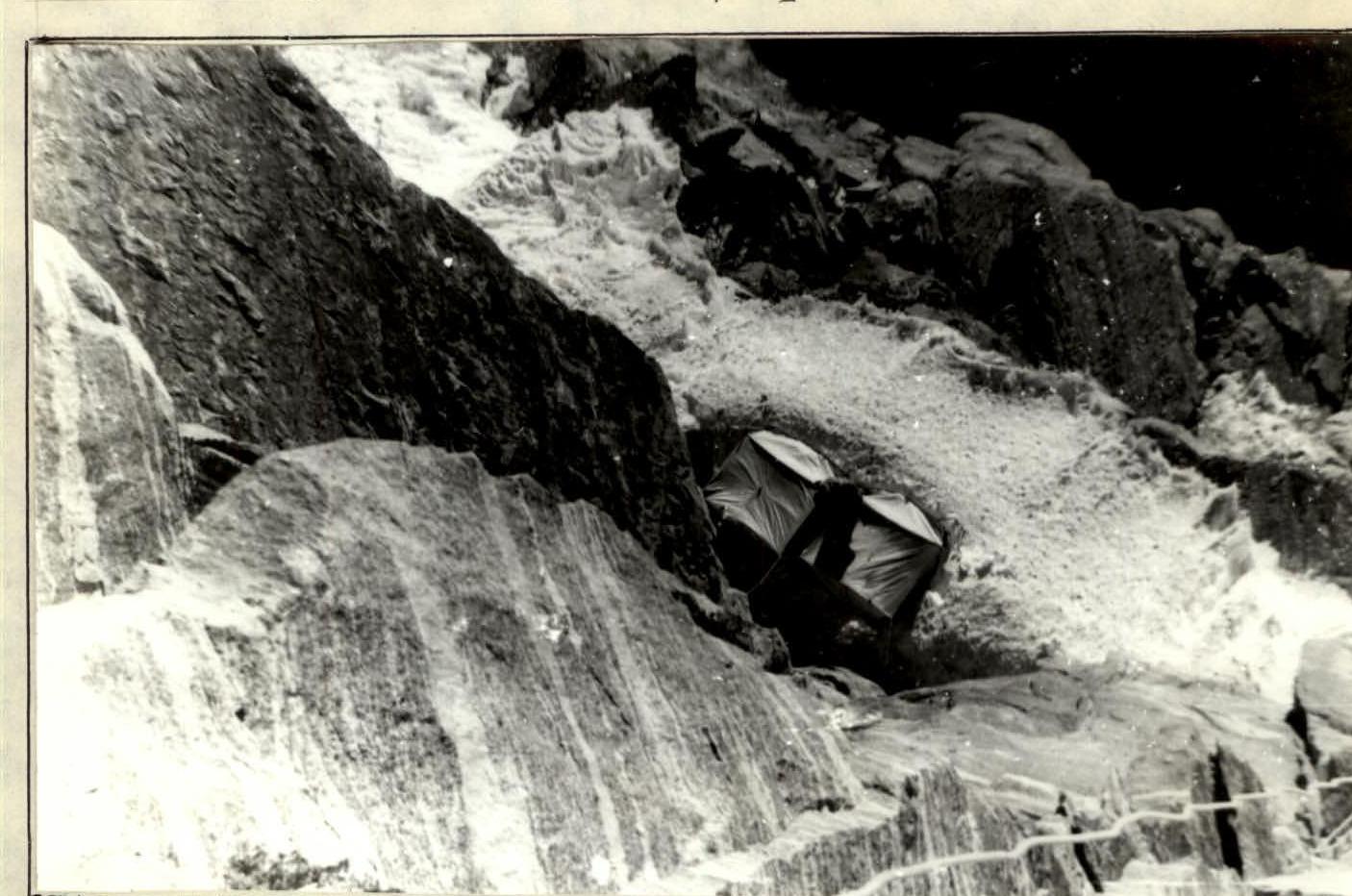
View from above of R2 bivouac, section R14-R15.
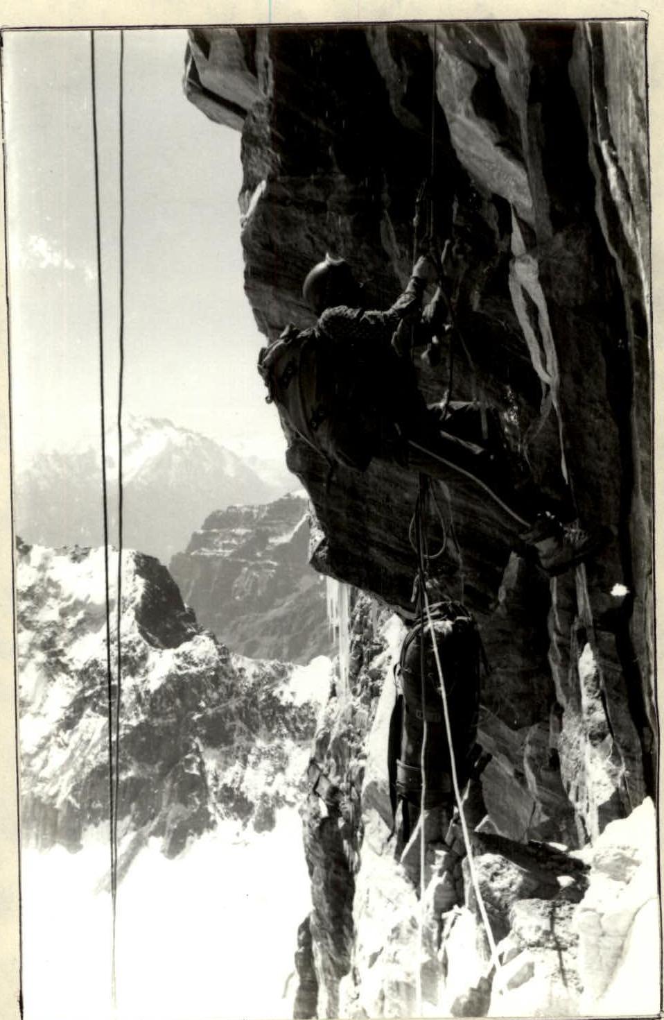
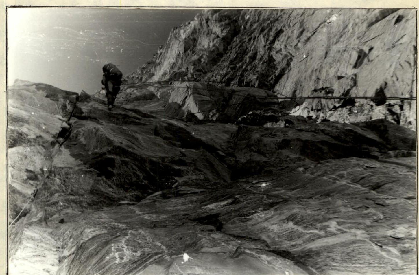
On fixed ropes, section R35-R36, 6th category of difficulty.