To the USSR Championship in Alpinism
Report on the Ascent of Peak Engels via the East Face
(Category: High-altitude Technical Ascent)
Expedition Leader — Master of Sports USSR, Senior Instructor LEVIN B.V. Team Coaches:
- Honored Coach of the RSFSR, Master of Sports USSR MARKOV V.G.
- Master of Sports USSR, Senior Instructor PLYSHCHEVSKY M.A.
Team Members:
- Captain: MALTSEV V.F.
- Deputy Captain: OVCHINNIKOV M.F.
- BAKULIN A.A.
- MALYHIN Y.M.
- SOLOVYEV G.S.
- POLYAKOV G.F.
- MIRONOV V.I.
- SOLOVYEV Y.A.
The ascent is dedicated to the 50th anniversary of the USSR
MOSCOW 1972
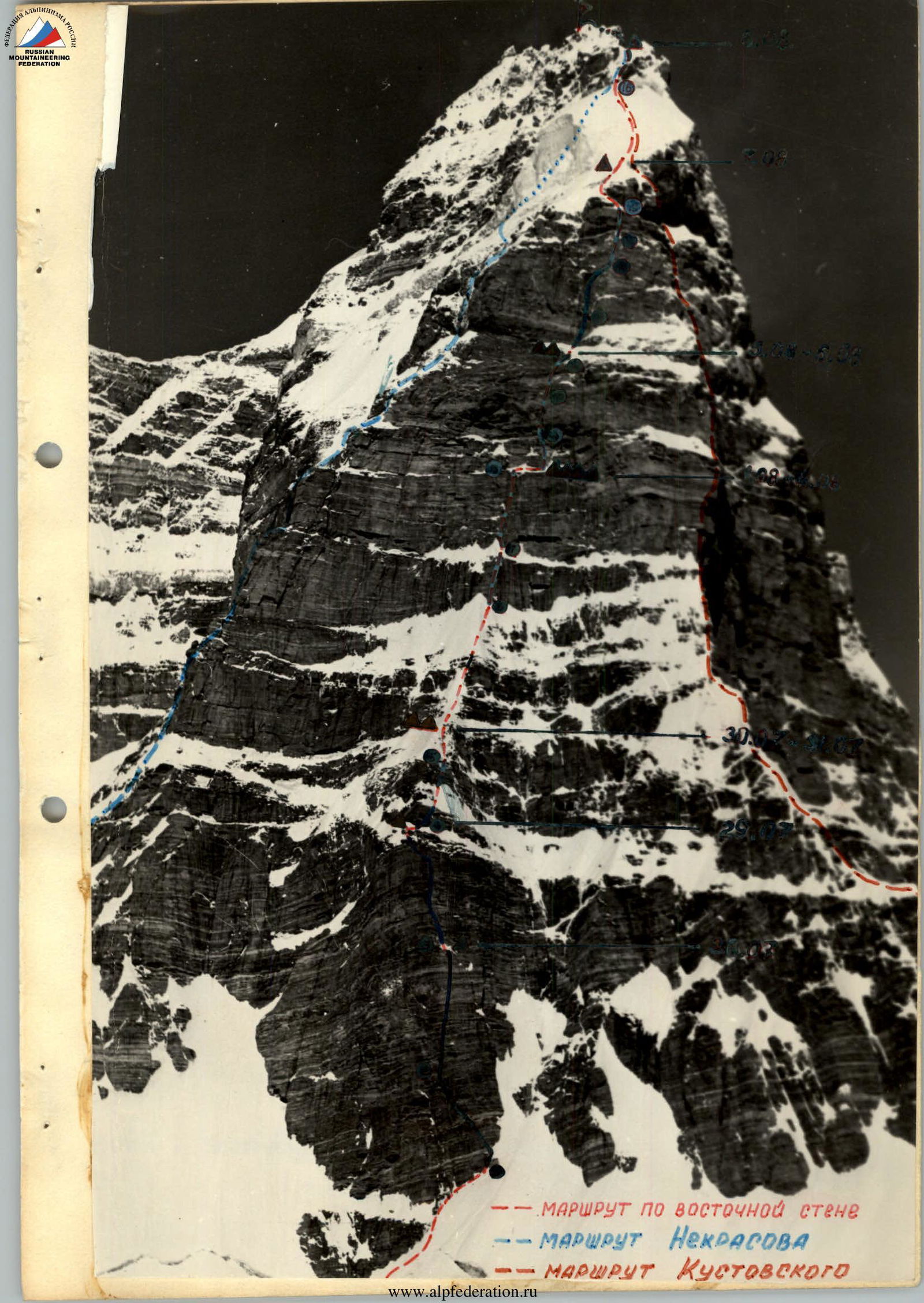
- ROUTE along the East face
- NEKRASOV's ROUTE
- KUSTOVSKY's ROUTE
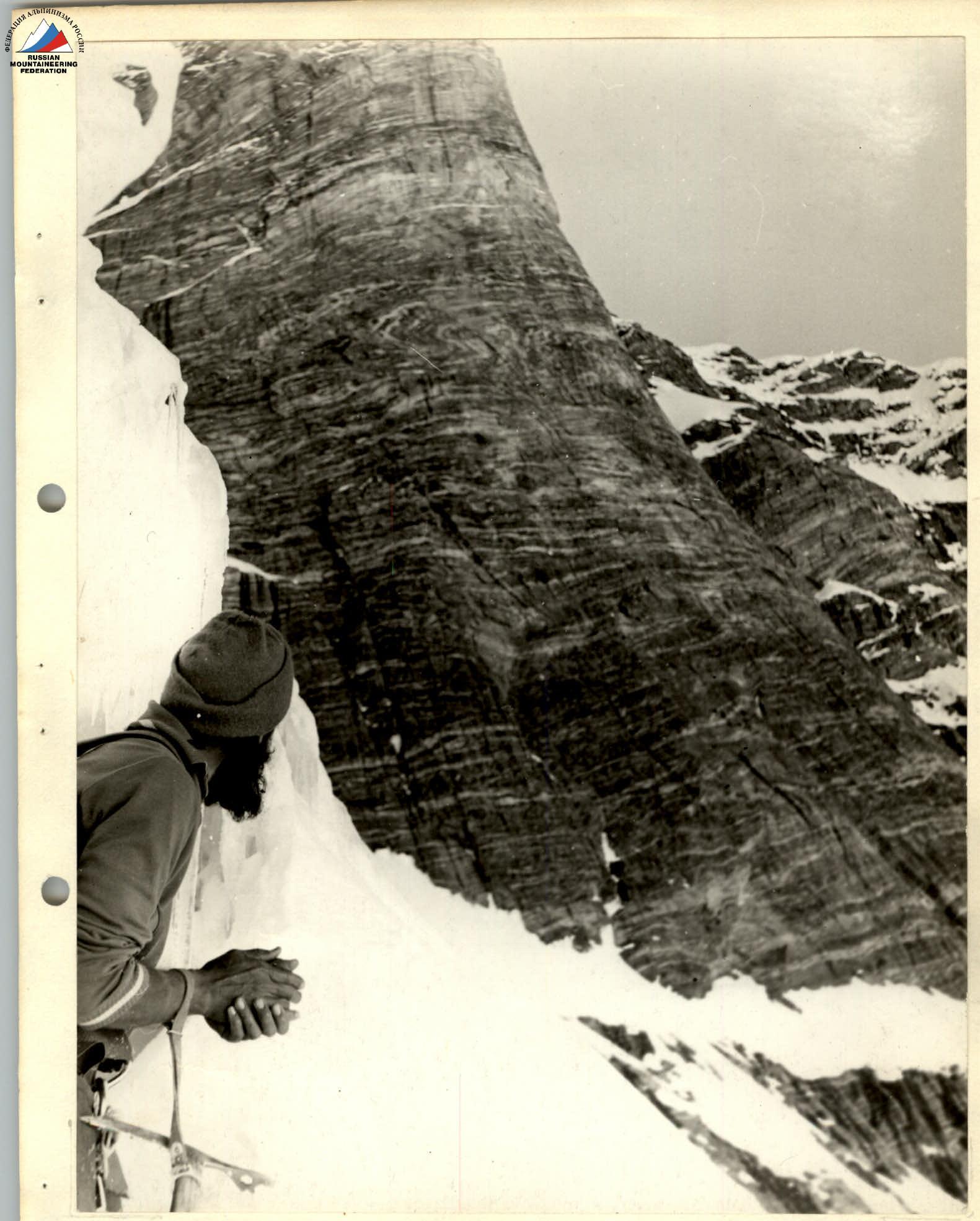
Fig. 2. Profile of the lower part of the bastion. In the background — the start of Kustovsky's route.
The group worked on the route for all 15 days without resupplying food. The observation group maintained communication with the base camp using a "Nedra" radio station.
Thus, the base camp received full information about the group's status three times a day. Additionally, the group's work and bivouacs were clearly visible from the "4100" camp through a 60x telescope. The entire route was traversed in full view of several expeditions.
As an emergency communication means, flares were taken. A doctor was present on the plateau under the wall during the group's ascent. Later, after the team began moving along the ridge, the observation group with the doctor moved to the "5200" pass in the southern spur of Peak "40 let LKSMU".
The rescue team included:
- MS B. Levin
- MS M. Plychevsky
- CMS E. Zubov
- CMS A. Ilyin
- 1st sports category P. Boldyrev
- 2nd category athletes I. Zavgorodniy, S. Vyazmin, M. Bushuev
After the team completed the wall section of the route and reached the ridge, a counter-ascent was organized by the auxiliary group. The sports group of 7 people led by B. Levin ascended via the southwest ridge to Peak "40 let LKSMU", clearing the path for the team's descent.
6. Chronology and Description of the Route
On July 28, V. Maltsev, A. Bakulin, and G. Solovyev set out from the camp located on the plateau under the wall at an altitude of 5100–5200 m to process the lower part of the bastion.
The slopes under the couloirs surrounding the bastion were traversed in the lowest part, below the avalanche cones. A steep snow slope with two narrow bergschrunds (section № 1) led the trio to the rocks. From the foot, the bastion's outline resembled a giant chess rook:
- a smooth, wide base, softly and semi-circularly bordering the snow;
- a slight narrowing in the central part;
- a smooth expansion of the upper part, overhanging along the entire perimeter of the bastion.
After a detailed inspection of the bastion's micro-relief, it was decided to ascend via the right side, where some rock fragmentation was observed. A vertical crevice 60 m above served as a landmark.
That day, 100 m of the bastion wall was traversed, and a sitting overnight stay was organized on a ledge (bivouac № 2 "5320"). The average steepness of the traversed part of the bastion is 80°. The bastion's rocks are monolithic, with few smooth holds and cracks. In the middle of the traversed section (upper part of section № 2), due to the absence of cracks for a hook over a 15 m stretch, a bolt hook had to be hammered for insurance.
The vertical crevice, allowing in some places to wedge the toe of a boot and hand, enabled the passage of a 40-meter sheer section (№ 3) before the ledge with an overhang on the last 5 m without using ladders. The entire section was led by V. Maltsev in "Vibram" boots.
On July 29, the remaining 5 participants ascended to the ledge via the hung ropes and organized the extraction of backpacks, while the three pioneers continued processing the upper part of the bastion.
Section № 4 consisted of:
- a vertical 40-meter internal corner,
- transitioning into a sheer 40-meter chimney,
- overhanging in the upper part with a cornice protrusion of about one meter.
The cornice is formed by a smooth slab with a horizontal ceiling and overlaps the entire chimney. There are no crevices at the edges outside the chimney. Climbing the chimney is extremely challenging, but reliable insurance and solid rock made it calm, although unpleasant due to bad weather and the chimney being wet with seepage ice.
To pass the cornice, a hook was hammered into the crevice under it, and a pendulum move was made 3 m to the left to a small shelf visible beyond the chimney (the cornice ended before reaching the shelf). This very tense section was masterfully passed by V. Maltsev.
Since the complexity of climbing did not allow for gloved movement, progress was slowed by the need to warm hands periodically. There were no convenient places to rest in the chimney, and breaks had to be taken in a semi-hanging position on a hook. Rest was always very short due to rapid body cooling — the sun did not penetrate this gloomy chimney.
A sheer 5-meter wall above the shelf led to a steep and wide internal corner, about 5 m long, filled with snow (with ice underneath), the ascent of which completed the exit to a large shelf with a snowdrift — a convenient place for a bivouac.
It took more than 6 hours of work to traverse 80 m of the upper part. The rest of the day was spent:
- extracting backpacks,
- setting up a bivouac,
- traversing the chimney via fixed ropes.
Late that evening, the entire team gathered on the upper part of the bastion (bivouac № 3 "5410") after extracting their backpacks. The average steepness of the section is more than 90°.
On the ledge in the middle of the bastion, the 1st control tour was left (a can tied to a hook).
On July 30, the team exited onto the ridge connecting the bastion to the main wall, traversing two vertical walls of 40 m each with a snowy ridge between them (section № 5).
If the first wall is traversed by free climbing in the central part, the second wall upwards —
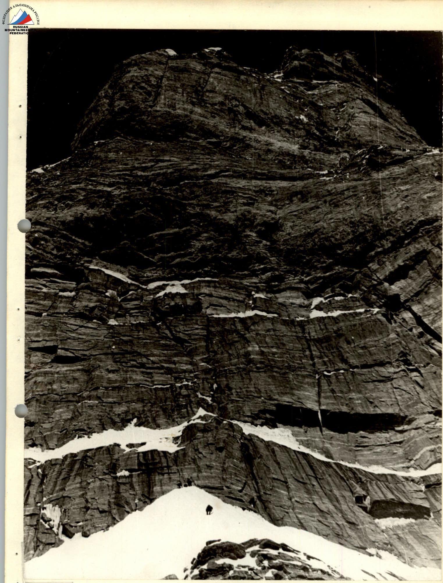
Fig. 3. View of the wall from the top of the bastion. The lower part ends with a 10-meter, slightly overhanging, internal corner with a crack in the middle. Ladders were required to traverse the corner. The average steepness of the section is 60°. Bivouac № 4 "5560" was comfortably set up on the ridge after more than two hours of snow and ice chopping. Despite very low temperatures (down to –20°C), a good rest was had at night.
On July 31, from bivouac № 4, V. Maltsev, G. Solovyev, and A. Bakulin set out for further route processing. After traversing 100 m of a snowy ridge with a steepness of 45–50°, transitioning above into a steep snow-ice slope about 40 m long (section № 6), they hung ropes on the 1st gray belt (section № 7) and the lower part of the 2nd gray belt (section № 8). The succeeding trio — V. Mironov, M. Ovchinnikov, G. Polyakov — completed processing the 2nd gray belt and secured the ropes on a ledge above the belt.
At the junction with the wall of the wide and steep snowy ridge, the 1st belt forms a large, not clearly expressed, external corner with a steepness of about 75°, along the right face of which the route was laid. A few dozen meters to the left, the 1st gray belt narrows, forming a wide couloir, but the path there is dangerous due to giant icicles hanging from above, occasionally falling down, and snow layers sliding from the ledge above the belt.
Up the gray granite of the 1st belt, narrow cracks with smoothed edges run with a slight slope. Small ledges for one or two tri-cones and insurance through petal hooks allowed traversing the belt by free climbing, resting on hooks (V. Maltsev).
The 2nd gray belt, separated from the 1st by a steep snowy ledge, is steeper and wider than the 1st belt. Its lower part, with many cracks, was traversed by free climbing, and the upper part —
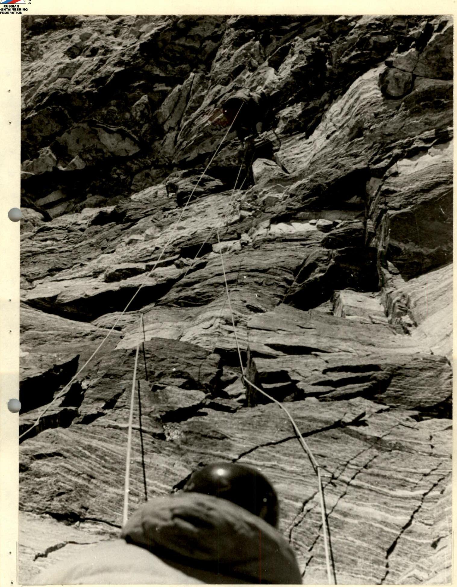
Fig. 4. Working on a ledge on the gray belt. The upper part, about 20 m long, is sheer with three overhanging steps, with few vertical crevices suitable for hammering wedges, and was traversed using ladders (V. Mironov). Climbing on ladders was complicated by the crevices being clogged with dirty ice. Hooks were hammered in poorly and would sometimes come out after a while. This forced working at a faster pace and with greater nervous tension. The source of dirt and ice was a steep, rocky ledge with snow under the 2nd gray belt. The average steepness of the 2nd gray belt is 90°. By the end of the day, the entire team gathered at bivouac № 4.
On August 1, the bivouac was moved to a ledge above the gray belts (bivouac № 5 "5750"), and 20 m of the 1st red belt were processed. The first night at bivouac № 5 was spent sitting, and the next day, convenient platforms were shaped from wet snow. The previous day, this work was impossible due to the dryness of the snow after the wall was no longer illuminated by the sun: the upper and middle parts of the wall are illuminated by the sun from sunrise to 12:30.
The lower part of the rocks of the 1st red belt (section № 9) has a steepness of about 75° and is composed of fairly strong rocks with few crevices convenient for hammering wedges. However, twenty meters above, a rock cornice begins. The true dimensions of the cornice were not apparent when viewed from below (even from the ledge above the gray belts) and were only revealed two days later. To ensure that a climber descending via a free rope from the upper part of the cornice could reach the bivouac ledge, it had to be pulled 2–3 m towards the ledge. The lower part of the cornice has several almost horizontal overhanging steps, each about half a meter wide. The upper part appeared vertical from below, instilling hope in each climber of a quick exit from under the cornice. However, after starting work on this section, each time the lower end of the ladder hung on a newly hammered hook deviated 20–30 cm from the rock. The overall protrusion of the cornice turned out to be 8–10 m. The cornice crossed almost the entire red belt, decreasing in the direction of Kustovsky's route (to the right). However, the path there was dangerous due to chunks of ice flying down with a whistling sound. To the left, the cornice increased, and its top was also bombarded with ice.
On August 2, 3, and 4, the processing of the 1st red belt continued, and bad weather was endured. The rock quality of the belt justified the worst expectations. The scarcity of cracks made it difficult to use regular hooks, and to ensure reliable insurance with bolt hooks in soft, easily delaminating rocks, it was necessary to find stronger parts of the wall. Due to the ascent path along the cornice (section № 10) leading to massive slabs not firmly attached to the main rock, three times it was necessary to move pendulum-style to the side (first Ovchinnikov, then Maltsev and Bakulin) to bypass unreliable slabs, changing the direction of movement.
From above, from where the next "equilibrist" worked, a whole rope system stretched down to the ledge with tents: 2 ropes for insurance, a vertically hanging rope for quick free descent, a rep cord for extracting light equipment and supplies for the worker, and later a main rope for extracting backpacks.
The cornice was traversed mainly by the aforementioned trio.
The upper part of the cornice and the following 50-meter vertical section (№ 11) presented a new unpleasant surprise
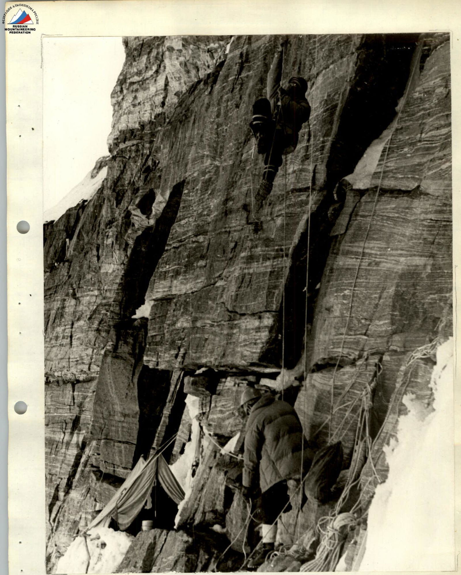
Fig. 8. Morning exit to process the route. Surprise: the rocks (friable sandstone) were moist. In these conditions, a scraper for cleaning holes for bolt hooks performed well, easily removing sludge and rock debris formed during drilling. The usual blowing with bulbs did not help.
To traverse the 120-meter 1st red belt, the following were hammered:
- 23 bolt hooks
- 40 regular hooks
- 4 bolt hooks for organizing a suspension system for extracting backpacks
The cornice with an overhang of more than 8 m and about 20 m of sheer wall above the cornice were traversed using ladders and a platform, while the remaining part was traversed by free climbing. Traversing the 1st red belt required the team more than 30 hours of intense work.
A 2nd control tour was left at the bivouac site. On August 5, the bivouac was moved under the 2nd red belt. Platforms for bivouac № 6 "5870" were:
- partially carved into the rock mass on an inclined ledge made of soft rock;
- partially laid out of snow, requiring six people to work for three hours.
That same day at 16:00, processing of the 2nd red belt began. Its characteristics are similar to those of the 1st red belt, except that instead of overhanging, the slope was sheer.
After overcoming the first ten meters of heavily destroyed rocks (section № 12), the further slope appeared simpler: a wide internal corner with a crevice in the center led upwards to the left, transitioning above into a slope with a steepness of about 75°. However, the path along the crevice of the internal corner led to a dead end: the slope above was smooth without cracks. To traverse it would require about 30 m of bolt work. It was necessary to move to the right onto a sheer wall. In this part (section № 13 — the middle part of the 2nd red belt), the rock structure changed somewhat: instead of plate-like, easily detachable rocks, vertical blocks with crevices between them predominated. Many blocks were not rigidly connected to the main mass. The M. Ovchinnikov — Yu. Solovyev team processed 30 m of the wall that day and descended to the night's rest at 20:00.
On August 6, the 2nd red belt with a length of 120 m was traversed to the foot of the summit tower of the wall (in the lower part, M. Ovchinnikov led first, and in the upper part, V. Maltsev). The belt was traversed by free climbing with thorough hook insurance.
Climbing was very challenging, further complicated by snow fallen the day before, and required great accuracy due to the fragility of the rock. The steepness of the 2nd red belt is 90°, and its length is 120 m.
The part of the team not involved in processing the route worked on improving the bivouac, and the next night was spent in more comfortable conditions.
On August 7, the team ascended via the hung ropes to the foot of the tower (section № 15), and while part of the team was extracting backpacks, the tower was traversed by the trio Ovchinnikov, Maltsev, Bakulin. The solid rocks of the tower pleasantly contrasted with the rock of the red belts, and rare wide crevices allowed for reliable insurance. In the central part of the tower, a small cornice with an overhang of about half a meter necessitated the use of ladders and a platform. The average steepness of the tower is 90°, and its height is 40 m. It took about three hours to traverse.
The inclined snow-covered ledge in the upper part of the tower completed the wall section of the route: on the left, the ledge connected with the snowy slope of the wide ridge.
To the left and slightly above the exit point of the ledge, a sheer slope of the icefall shone:
- chunks of ice from it covered the left part of the wall;
- icicles hanging from the tower to the right bombarded the right part.
By evening, the team gathered on the slope and set up bivouac № 7 "6070", chopping two platforms into the slope's ice.
A 3rd control tour and a bag with some unnecessary equipment were left on the ledge under the summit tower of the wall.
On August 8, at 9:00, the first teams left the bivouac and began making their way up through deep snow frozen to the ice (section № 16). Yu. Malyhin started tracing the path upwards. For insurance, mainly screw ice hooks were used. The 120-meter-long section required two hours of heavy physical work:
- tracing a trench through waist-deep snow
- digging holes for hammering hooks.
At the junction of the snowy slope with the upper part of the icefall, a cornice about 5 m high with a very slight protrusion was formed (section № 17). To traverse it, it was necessary to chop a deep vertical trench in the snow (Malyhin).
A horizontal, wide section (№ 18) at the top of the icefall allowed for rest after the heavy work.
The exit onto the ridge slope (sections № 19–21) brought several more "surprises":
- numerous cornices, some of which were rotated across the ridge, so it was necessary to chop through them;
- deep snow covered with a thin crust on top, dry and crumbly underneath;
- icy sections of the ridge with holes in the middle, masked by fresh snow.
V. Maltsev fell into the first hole up to his waist, giving the team a chance to familiarize themselves with this unusual relief form. For insurance through rock hooks, it was necessary to clear the rocks of a thick layer of snow on an icy substrate.
The group spent the night at an altitude of about 6300 m, chopping platforms into the snow-ice slope (bivouac № 8).
Despite snow, wind, and severe frost, M. Ovchinnikov processed 80 m of the ridge that evening.
On August 9, the team continued advancing along the ridge, overcoming gendarmes and cornices, and spent the night in the immediate vicinity of the summit at an altitude of 6500 m (bivouac № 9). One of the most challenging sections of the ridge was a sharp ice knife (section № 21), about 20 m long, before the second gendarme from the summit. Insuring through ice hooks and chopping off the top of the knife, V. Maltsev led through it first.
Climbing the gendarmes was not particularly challenging — routine work on a route of 5th category difficulty. It should be noted that by this time, despite thorough impregnation before departure, boots had started to get wet. Canvas gaiters covering the boot lacing helped little.
From the moment of departure in the morning, boots would freeze and by evening become so stiff that:
- the outer woolen sock and lower insole would stick firmly to the boot.
This, firstly, required spending a lot of time removing boots in the evening and warming them on a primus stove in the morning, and secondly, made the boots less sensitive to rock during climbing. All this somewhat slowed down the movement (despite early rises).
On August 10, at 10:00, all participants of the ascent, having traversed a 45-degree ice edge (section № 22) about 100 m long, reached the summit of Peak Engels.
From the summit tour (a fragment of an ice axe with a tied signal rocket body), a note from V. Bozhukov's group dated August 25, 1971, was retrieved.
The descent via the southwest ridge through the summit of Peak "40 let LKS MU" presented no technical difficulties; the descent path, starting from the summit of "40 let LKS MU", was indicated by the tracks of B. Levin's group, which had descended a day earlier and had been observing and interacting with the team.
At 18:00, the team stopped for the night in the lower part of the ridge connecting this peak to Peak K. Marx. For descent, loops made from rep cord left by the interaction group were used several times.
On the morning of August 11, the group descended to glacier Zugvand, reached the "5200" pass by 11:30, and returned to the "4100" base camp by 17:00, accompanied by observers. That same evening, a debriefing of the ascent was conducted.
7. Table of Main Route Characteristics
Ascent Route: Peak Engels with ascent via the East face. Route elevation difference: about 1400 m. Including the most challenging sections: about 800 m. Average steepness of the wall section of the route: 80°.
| Date | Steepness | Height, m | Relief Characteristics | Technical Difficulty | Passage Method and Insurance | Weather Conditions | Time Taken | Rock Hooks | Ice Hooks | Bolt Hooks | Bivouac Conditions | Daily Food Ration Weight, kg |
|---|---|---|---|---|---|---|---|---|---|---|---|---|
| 1 | 2 | 3 | 4 | 5 | 6 | 7 | 8 | 9 | 10 | 11 | 12 | 13 |
| 28.07.72 | 1 | 50° | 100 m | Snow slope with narrow bergschrunds below the bastion. Deep snow. | Category 4 difficulty. Physical work on tracing a trench in snow. Chopping steps when overcoming bergschrunds. Insurance through ice axe. | Overcast weather | 19:30 | 9:30 | 10 | 0 | 0 | Sitting overnight on a ledge in the middle part of the bastion. Height 5320 m. |
| 28.07.72 | 2 | 75–80° | 50 m | Lower part of the bastion. Monolithic rock with few cracks and smoothed holds. Solid rock. | Category 5 difficulty. Complex free climbing with hook insurance on a double rope. Maximum use of friction (Vibram boots). One bolt hook hammered in the upper part (no cracks for a regular hook). | Fog, wind, light snow | 21:00 | 9:00 | 12 | 7 | 1 | Bivouac № 2. Sitting overnight on a ledge in the middle part of the bastion. Height 5320 m. |
| 29.07.72 | 3 | 90° | 50 m | Middle part of the bastion: vertical wall with an overhang on the last 10 m, cut by a crevice with smoothed edges. Monolithic rocks with small smooth ledges (for 2–3 conically shaped holds). Exit via the crevice onto a ledge in the central part of the bastion. Ledge size 0.5 m × 3 m. | Complex category 6 difficulty. Free climbing using toe wedging and smooth ledges. Insurance through wedges hammered into the crevice. Double rope. Two bolt hooks hammered on the ledge for extracting backpacks. | 19:00 | 9:00 | 10 | 16 | 1 | Good platforms on snow after exiting onto the bastion under the 40-meter wall. Bivouac № 3. Height 5410 m. | |
| 29.07.72 | 4 | 90° | 80 m | Upper half of the bastion: vertical internal corner transitioning 40 m above into a vertical chimney filled with seepage ice. Horizontal cornice in the upper part with a 1 m protrusion. Solid rock with sufficient narrow cracks. Exit from the cornice onto a ledge. After the ledge, a 5-meter wall and a 60° slope with about 5 m of snow. Exit onto a 1.5 m × 4 m ledge with a snowdrift. | Very complex category 6 difficulty. Very complex free climbing on a double rope with hook insurance. Cleaning the chimney of ice with an ice axe. Pendulum move from under the cornice. Extracting backpacks: one bolt hook hammered for this. | Fog, wind, snow. Clearing by evening | 19:00 | 9:00 | 10 | 16 | 0 | Good platforms chopped on a snowy ridge after overcoming walls. Bivouac № 4. Height 5560 m. |
| 30.07.72 | 5 | 60° | 140 m | Two vertical walls of 40 m each, connected by a snowy ridge. Solid rocks with sufficient fragmentation. On the 2nd wall, a 10-meter overhanging internal corner with a crevice in the middle. Exit onto a snowy ridge after the 2nd wall. | Complex category 6 difficulty. Free climbing on the 1st wall. Use of ladders on the internal corner of the 2nd wall. Double rope. Extracting backpacks on the walls. | Good weather | 19:00 | 9:00 | 10 | 16 | 0 | Good platforms chopped on a snowy ridge after overcoming walls. Bivouac № 4. Height 5560 m. |
| 31.07.72 | 6 | 50° | 120 m | Snowy ridge with rock outcrops connecting the bastion to the main wall. When approaching the 1st gray belt, the ridge transitions into a snow-ice slope with a steepness of 50–60°. | Category 3 and 4 difficulty. Movement with alternate insurance through ice axe. Overcoming the snow-ice slope with insurance through ice hook. | Good weather | 2 | 1 | 0 | |||
| 31.07.72 | 7 | 75–80° | 50 m | First gray belt: Complex monolithic rocks made of hard rocks. Few very narrow cracks. Small smoothed ledges for one or two conically shaped holds. | Category 6 difficulty. Free climbing on a double rope with insurance through petal hooks. Maximum use of friction. Hanging ropes for the entire team. One bolt hook hammered to secure the ropes. | Good weather | 9 | 1 | ||||
| 31.07.72 | 8 | 90° | 70 m | Second gray belt: Very complex sheer wall — the lower part is vertical, the upper 15 m overhangs with three steps. Solid rocks. Few vertical crevices. Crevices in the overhanging part are clogged with ice and dirt. Exit in the upper part onto a scree ledge (45°, 1 m wide) with snow. | Very complex category 6 difficulty. | In the lower part, free climbing with hook insurance. The upper overhanging part was traversed using ladders with wedges hammered into crevices. Double rope. Hanging ropes. | Good weather | 19:00 | 9:00 | 10 | 24 | 0 |
| 01.08.72 | 9 | 70–75° | 20 m | Inclined rock section of the 1st red belt above the ledge. Rocks are solid, large blocks (several meters high) separated by crevices. | Category 5–6 difficulty. Free climbing with hook insurance on a double rope. Vibram boots. | Good weather | 6 | 0 | ||||
| 02.08–03.08.72 | 10 | 105° | 50 m | Rock cornice of the lower half of the 1st red belt. In the lower part, several horizontal steps ("inverted") about half a meter wide each. In the upper part, the relief is smoother. Rock is brittle and unreliable sandstone of a plate-like structure. Plates are not firmly connected to the main rock. Few cracks, and those that exist do not go deep into the mass. Overall cornice protrusion is 8–10 m. | Very complex category 6 difficulty. Complex climbing exclusively using a platform and ladders. Frequent use of bolt hooks due to the absence of cracks. Use of regular hooks for organizing temporary points of support. Three times moving pendulum-style from unreliable slabs and again moving upwards. Double rope, Vibram boots. Hanging ropes for the team. | Overcast, wind, occasional snow | 20:00 | 9:30 | 10 ч 30 мин | 26 | 14 | Reconstructed previous bivouac: convenient platforms for tents shaped from snow. Bivouac № 5. Height 5750 m. |
| 04.08.72 | 11 | 90° | 50 m | Upper half of the 1st red belt. Very fragile rock like sandstone. Few holds and cracks. Rocks are damp, hammering bolt hooks is difficult. Exit onto a scree ledge with snow above the belt. Ledge steepness is 45°, width is about 1 m. | Very complex category 6 difficulty. Very complex free climbing with insurance through regular and bolt hooks. In some places, use of a platform and ladders. Double rope. Vibram boots. Four bolt hooks hammered to organize extracting backpacks. | Good weather | 20:00 | 9:00 | 11 | 19 | 13 | Previous bivouac. |
| 05.08.72 | Traversing sections № 9, 10, 11 via fixed ropes. Extracting backpacks. Organizing a bivouac on a ledge above the 1st red belt. | Good weather. Snowfall started at night. | 19:00 | 8:00 | 11 | Satisfactory overnight stay on a platform carved into rock and laid out with snow. Bivouac № 6 "5870". | ||||||
| 06.08.72 | 12 | 90° | 30 m | Lower part of the 2nd red belt, composed of very friable rocks, heavily eroded. Cracks are typically formed by "live" stones. Choice of spot for hammering hooks is limited. | Very complex category 6 difficulty. Very complex free climbing. Long hooks and wedges were suitable for insurance. One bolt hook hammered. Double rope. Vibram boots. | 10 | 1 | |||||
| 06.08.72 | 13 | 90° | 70 m | Middle part of the 2nd red belt; composed of red, heavily eroded rocks (white quartz, sandstone) in small blocks. Many small overhanging sections (inverted steps). Many "live" blocks. | Very complex category 6 difficulty. Very complex free climbing on a double rope with hook insurance. Several times ladders were used to traverse overhanging sections. | Fog, wind, snow | 19:00 | 8:30 | 11 ч 30 мин | 16 | 1 | Bivouac № 6 "5870". |
| 06.08.72 | 14 | 90° | 20 m | Upper part of the 2nd red belt. Extremely destroyed section. Very difficult to choose a reliable path. | Very complex category 6 difficulty. Complex free climbing with hook insurance on a double rope. Great care is necessary to avoid dislodging "live" stones. | Fog, wind | 18:30 | 8:30 | 10 ч | 4 | 0 | Bivouac № 6 "5870". |
| 07.08.72 | Traversing sections № 12, 13, 14 via fixed ropes. Extracting backpacks. Two bolt hooks hammered to secure the extraction system. | Good weather | 0 | 2 | ||||||||
| 07.08.72 | 15 | 90° | 40 m | Upper tower of the wall, composed of solid rocks with moderate fragmentation. Small cornice (0.5 m protrusion) in the middle of the section. | Very complex category 6 difficulty. Complex free climbing with insurance on a double rope through hooks. Use of ladders and a platform when traversing the cornice. | Good weather | 3 | 16 | 0 | |||
| 07.08–08.08.72 | 16 | 45° | 200 m | Slope covered with deep snow, not firmly frozen to the ice underneath. Snow is covered with a fragile crust on top; underneath it is loose. | Category 4 difficulty. Heavy physical work on tracing a trench in snow. Insurance using ice hooks. Alternate movement. | Good weather | 12:00 | 18:00 | 9 | 6 | 0 | Bivouac № 7, "6100", to the right of the icefall. Platforms chopped into the ice slope. |
| 08.08.72 | 17 | 90° | 5 m | Vertical cornice-like formation at the junction of the snowy slope and the upper part of the icefall. | Category 6 difficulty. Chopping a vertical trench in the loose snow of the cornice. Insurance through an ice hook hammered at the bottom. | Fog, snow at 12:00 | 12:00 | 18:00 | 9 | 0 | 0 | |
| 08.08.72 | 18 | 15° | 200 m | Almost horizontal snowy slope above the icefall. Deep snow. | Category 2 difficulty. Alternate insurance during movement (through ice axe). | Fog, wind, snow | 0 | 0 | ||||
| 08.08.72 | 19 | 70° | 60 m | Approach along an ice slope about 40 m long to a gendarme on the ridge. Gendarme is composed of solid rocks with sufficient fragmentation. | Category 5 difficulty. Free climbing with insurance through ice and rock hooks. | Fog, wind, snow, frost | 3 | 0 | ||||
| 08.08. |