
Ascent Passport
- Ascent class: high-altitude technical ascents.
- Ascent area: 4.11 (South-West Pamir).
- Ascent object and route: p. Churlyonis (5800 m) via the center of the West Face.
- Proposed difficulty category: 4B.
- Route characteristics: height difference — 600 m, average steepness — 58°, length of sections by difficulty categories: 1–0 m, 2–270 m, 3–350 m, 4–120 m, 5–55 m, 5B–84 m.
- Pitons driven:
- rock: for belay — 47, for creating RTO (Relay and Turning Point) — 8
- ice: for belay — 0, for creating RTO — 0
- bolt: for belay — 0, for creating RTO — 0
- Total climbing hours — 18.5.
- Number of nights: 1 overnight stay on a ledge under the bastion.
- Group composition:
- leader SOLONNIKOV V.A. — International Master of Sports
- participants:
- GRACHEV A.B. — International Master of Sports
- SOLONNIKOV Vl.A. — Master of Sports
- ANTONOVSKY D.I. — Master of Sports
- VASILYEV B.P. — Master of Sports
- PUGACHEV A.D. — Master of Sports
- VEDERNIKOV V. — Candidate Master of Sports
- STEPANOV N. — Candidate Master of Sports
- MANOILOV R.S. — Candidate Master of Sports
- ORLOV B. — Candidate Master of Sports
- PAVILAYNEN V.D. — Candidate Master of Sports
- NAZAROV O. — Candidate Master of Sports
- VERGILEOSOV F.V. — 1st sports category
- FEDOSOV A. — 1st sports category
- EPSHTEYN A.K. — 1st sports category
- GRACHEVA L.S. — 1st sports category
- Team coach — International Master of Sports SOLONNIKOV V.A.
- Departure to the route: July 23, 1977.
Return to base camp: July 24, 1977.

Area Map
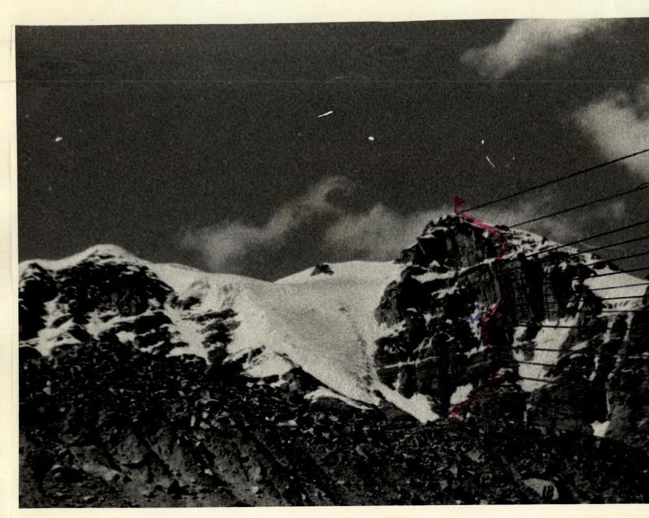
West Face of p. Chyurlyonis
- first ascent route
- Δ — overnight stay on the route
Approach to the Route Description
From the base camp located on a clearing at 4100 m in the Kyshty-Dzherob valley, follow the trail up the right (orographically) bank of the Kyshty-Dzherob river to the tongue of the glacier. This is the most convenient place for crossing. After crossing:
- follow the left slope of the valley
- then up the left lateral moraine to a clearing under the western spur of p. Danilaitis (3.5 hours from the base camp).
Then, move right along the moraine ridges to ascend to the start of the route — a snow cirque located between the glacier, which descends steeply to the southwest from the saddle between p. Danilaitis and p. Churlyonis, and the southern ridge of p. Churlyonis (2–2.5 hours from the clearing).
Route Description
Ascend the snow slope of the cirque with a steepness of up to 40° in the upper part to a rock island and from it up to a rocky-ice gully. Then, left of the gully, via a wide chimney — exit onto a small platform and from it up 20 m via icy rocks. Then, traverse the gully to the right for 1 rope length and another 40 m right-up via simple rocks. Further, 30 m via destroyed and very loose rocks and 40 m via moderately difficult rocks to exit onto an osypnaya (scree) platform. From it, 15 m up a steep snow ridge to an internal corner and then up the right side of the corner, transitioning into a rocky-ice gully — ascend 80 m to a ledge. Here, 2–3 tents can be set up and a bivouac organized. Above the ledge begin the rocks of the 120-meter bastion of the West Face. This is the key section of the route. The bastion is processed by two teams; the first works on a double rope, in crampons. Processing the bastion takes 4.5 hours.
From the ledge, 30 m via moderately difficult rocks and 20 m via difficult rocks — approach to overhanging slabs, then traverse right 4 m between two exfoliations, leading to a vaguely defined internal corner with an overhang in the middle part.
40 m of very difficult climbing up the corner using artificial holds lead to a narrow ledge under the overhanging wall, suitable for organizing belay.
Further:
- traverse 5 m to the right
- 40 m up via sheer rocks (very difficult climbing, artificial holds) to the beginning of the wall's easing of the bastion
- another 30 m of difficult climbing to a large osypnaya (scree) ledge
Then, via a snow-rock ridge, ascend to the summit ridge and along it 60 m to the summit of p. Churlyonis (cornices!).
The descent is made via the South Ridge on a route of 3A category difficulty to the glacier and then along the trail to the base camp.
The first ascent route via the center of the West Face of p. Churlyonis is logical, diverse, objectively safe, and evaluated by the coach and ascent participants as 4B category difficulty.
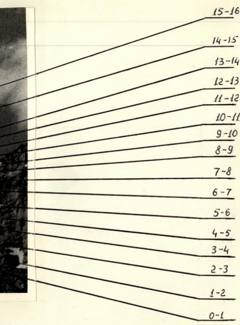
Main Characteristics of Route Sections
Table I.
| Date | Designation | Average Steepness in Degrees | Length in m | Terrain Characteristics | Difficulty | Condition | Weather Conditions | Rock Pitons | Ice Pitons |
|---|---|---|---|---|---|---|---|---|---|
| July 23, 1977 | R0–R1 | 25–40 | 180 | Snow slope with hard crust | 2 | Calga-spores | good | 0 | 0 |
| R1–R2 | 60 | 25 | Chimney, destroyed rocks | 3 | Icy rocks | good | 3 | 0 | |
| R2–R3 | 60 | 80 | Rocky-ice gully, destroyed rocks | 3 | Icy rocks | good | 7 | 0 | |
| R3–R4 | 50 | 30 | Heavily destroyed rocks | 2 | Rockfall | good | 2 | 0 | |
| R4–R5 | 65 | 40 | Rock wall | 4 | good | good | 4 | 0 | |
| R5–R6 | 50 | 15 | Steep snow ridge | 3 | good | good | 0 | 0 | |
| R6–R7 | 70 | 80 | Internal corner transitioning into rocky-ice gully | 4 | Icy rocks | good | 7 | 0 |
Departure from the clearing by the glacier — 5:30. Stop for bivouac — 15:00. Bastion processing — 15:30–20:00. Climbing hours (including bastion processing) — 12.5. Overnight stay on the ledge under the bastion, conditions good.
Table I (continued).
| Date | Designation | Average Steepness in Degrees | Length in m | Terrain Characteristics | Difficulty | Condition | Weather Conditions | Rock Pitons | Ice Pitons |
|---|---|---|---|---|---|---|---|---|---|
| July 24, 1977 | R7–R8 | 60 | 30 | Rocks of medium complexity | 3 | Monolith | overcast | 2 | 0 |
| R8–R9 | 75 | 20 | Steep rocks | 5 | Monolith | overcast | 3 | 0 | |
| R9–R10 | 95 | 4 | Traverse between overhanging exfoliations | 5B | Monolith | overcast | 2 | 1 | |
| R10–R11 | 90 | 40 | Vaguely defined internal corner | 5B | Monolith | fog | 5 | 4 | |
| R11–R12 | 90 | 5 | Traverse of overhanging slab | 5 | Icy rocks | light snow | 2 | 0 | |
| R12–R13 | 85 | 40 | Sheer rocks | 5B | Monolith | light snow | 4 | 3 | |
| R13–R14 | 75 | 30 | Steep smooth rocks | 5 | Monolith | light snow | 4 | 0 | |
| R14–R15 | 50 | 200 | Snow-rock ridge | 3 | Icy rocks | fog | 2 | 0 | |
| R15–R16 | 20 | 60 | Snow ridge | 2 | Cornices | good | 0 | 0 |
Departure from the bivouac under the bastion: 6:00. Reach the summit: 12:30. Climbing hours: 6.