Geological and Geographical Characteristics of the Area
Peak Chyurlenisa is located in the Shakhdarin Range (South-West Pamir) near peaks Engel'sa and Daneliaitis. With its eastern ridge, it ends a lateral spur of the Shakhdarin Range, which is located in a latitudinal direction and is surrounded by glaciers:
- Kishty-Dzherob (from the south)
- Kasper (from the north)
For Peak Chyurlenisa, as well as for most of the peaks in South-West Pamir, a horizontal arrangement of rock layers is typical.
A characteristic feature of the glaciation in this area is the short length of the glaciers, their extremely steep drop in the upper part, and very gentle slope in the middle and lower parts, with a small number of crevasses. The glaciers of the peaks in the area feed the Kishty-Dzherob Glacier. Its valley is 77 km long, and its surface is littered with moraine up to the highest reaches.
Peak Chyurlenisa is located almost at the top of a peculiar horseshoe that encompasses the Kishty-Dzherob Glacier. The eastern side of the horseshoe is a ridge consisting of peaks:
- "5491"
- "Moskovskoy Pravdy"
- "Pamyati Zhertv Tetnulda"
and the western side - of peaks "TGU" and "Litvy".
The open side of the horseshoe rests against the Pyandzh River, beyond which the panorama of Gindushuka opens up.
Sports Characteristics of Peak Chyurlenis
Peak Chyurlenisa is located in an area frequently visited by mountaineering expeditions, but it is not one of them.
For the first time, Peak Chyurlenisa was conquered by a group of Lithuanian climbers in 1964, who made a traverse: Peak Chyurlenisa - Peak Daneliaitis - descent to the saddle between peaks Engel'sa and Daneliaitis.
Composition of the Sports Group
The sports group that made the first ascent included:
- Master of Sports of the USSR SIMONENKO V.K.;
- 1st sports category IVANOV A.I. (leader);
- 1st sports category YAROSHENKO V.N.;
- 1st sports category LEVITSKIY E.I.
Joint training since 1959, belonging to the same society, and climbing together for many years in the Caucasus allowed them to:
- complete the planned ascent;
- maintain communication with the group observing from the base camp "4600" during the ascent.
Ascent
a) Route Description.
1st Day
Departure from the base camp "4100", located on the tongue of the Kishty-Dzherob Glacier, to the foot of the southern slope of the Chyurlenisa ridge (4750 m) - 4-6 hours.
2nd Day
Observation of the wall. Final selection and study of the route. Preparation for the exit.
3rd Day (July 5)
Section R0-R1. Departure at 4:00. Approach to the foot of the wall (40 min) - to the right angle of the huge snow square located under the lower wide rock belt of Peak Chyurlenisa. (See photo on p. 6)
Section I-2. We cross the square diagonally to the left upwards. Steepness 35-40°. Snow is calcareous. We quickly gain height. As we ascend, the steepness increases. In some places, regelation ice appears. Having passed about 3/4 of the diagonal - 3 ropes (50 min):
- we put on crampons;
- we tie in.
Section 2-3. Regelation ice, slightly dusted with snow. Steepness 45°. We pass one rope (50 min).
Section R3-R4. We enter a wide, left-upward-going couloir formed by the right buttress of p. Daneliaitis and the rock islands of p. Chyurlenisa. The couloir is clean. There are no signs of falling rocks or fresh avalanches. Insurance with ice screws (5 pieces). One and a half ropes (1 hour 40 min).
Section R4-R5. Foot of the snow-ice south-west wall. 
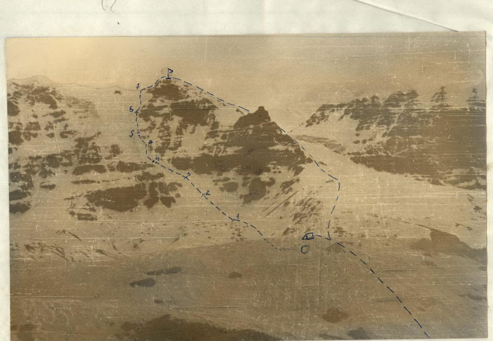
Along the right edge of the wall, on snow, one and a half ropes, and on top of the first elongated rocky island (from a distance, it looks like the letter 1), we leave a cairn. Even higher, 2.5 ropes on snow. Insurance through an ice axe. In total, four ropes on snow (2 hours 30 min).
Section 5-6:
- Pure glacier ice;
- Screw insurance (II cat.);
- Steepness 55°;
- One and a half ropes (2 hours).
Section 6-7:
- On snow to the very summit ridge;
- Insurance through an ice axe;
- Steepness 55-60°;
- Four ropes (1.5 hours).
Section 7-8. The ridge is snowy, in some places rocky. Movement is simultaneous. Two and a half ropes and the summit (1 hour).
Time of movement from the bivouac to the summit - 12 hours.
Section R8-R9. Descent from the summit along the ridge to the east, in the direction of the counter-traverse, is not particularly difficult (2A cat. of diff.). 6-7 ropes to the lowering of the ridge.
The danger is posed by:
- huge snow cornices (however, they are clearly visible from the summit).
The descent from the summit to the bivouac site in the base camp "4600" took 2.5 hours.
The total time of the ascent took 14.5 hours.
Conclusion
Main data on the route: Slope length 720-740 m; Average steepness 50-55°; Ice section 80-90 m, steepness 55°; Number of working hours on the route 14.5 hours; Number of driven-in hooks: ice 16 pieces, rock 3 pieces; 24 ropes of 40 m passed. The route taken by the group is logical and objectively safe.
Section R0-R4 should be passed before sunrise, as there are cases of rockfall from the middle of the rock massif of p. Chyurlenisa.
The group believes that deviating from the route taken creates additional difficulties.
The route was climbed in the most favorable conditions. At the end of July:
- section R3-R4 turns into ice;
- the length of the ice section R5-R6 increases.
Considering the steepness and complexity of the route, the group classifies it as 4A cat. of diff.
The preliminary report on the ascent was heard by the coaching staff of the Pamir expedition of the DSO "Avangard" and approved as a route of 4A category of complexity.
Group Leader
SIMONENKO V.
Senior Coach, Honored Master of Sports of the USSR
LIVSHITS