REPORT
On the ascent to the summit 5650 m «Tespara» via the western ridge
FIRST ASCENT
Team members:
NEKRASOV V.L. GORODETSKII V.I.
Team coach: MSМК NEKRASOV V.P.
August 26, 1976
I. Geographical description and sporting characteristics of the ascent object
The summit 5650 m (p. Tespara) is located in the Shakhdarin ridge of the southwestern Pamir between v. 5900 m (p. Luknitskogo) to the east and v. 6038 m (p. Baykonur) to the west.
The description of the ascent route is given in relation to the case of the location of the initial base camp in the Jarh valley (from the north of the Shakhdarin ridge). In the upper reaches, the Jarh valley is divided into two branches by the northern ridge of the Baykonur peak (6038), in which v. Korablik (5500) is located. The ascent to the beginning of the route is possible along each of them, however, the path along the left (orographic) valley is more convenient.
The first ascent to the summit was made by a duo of climbers from the combined team of the Armed Forces of the USSR, Nekrasov V.L. and Gorodetskii V.I., via the western ridge.
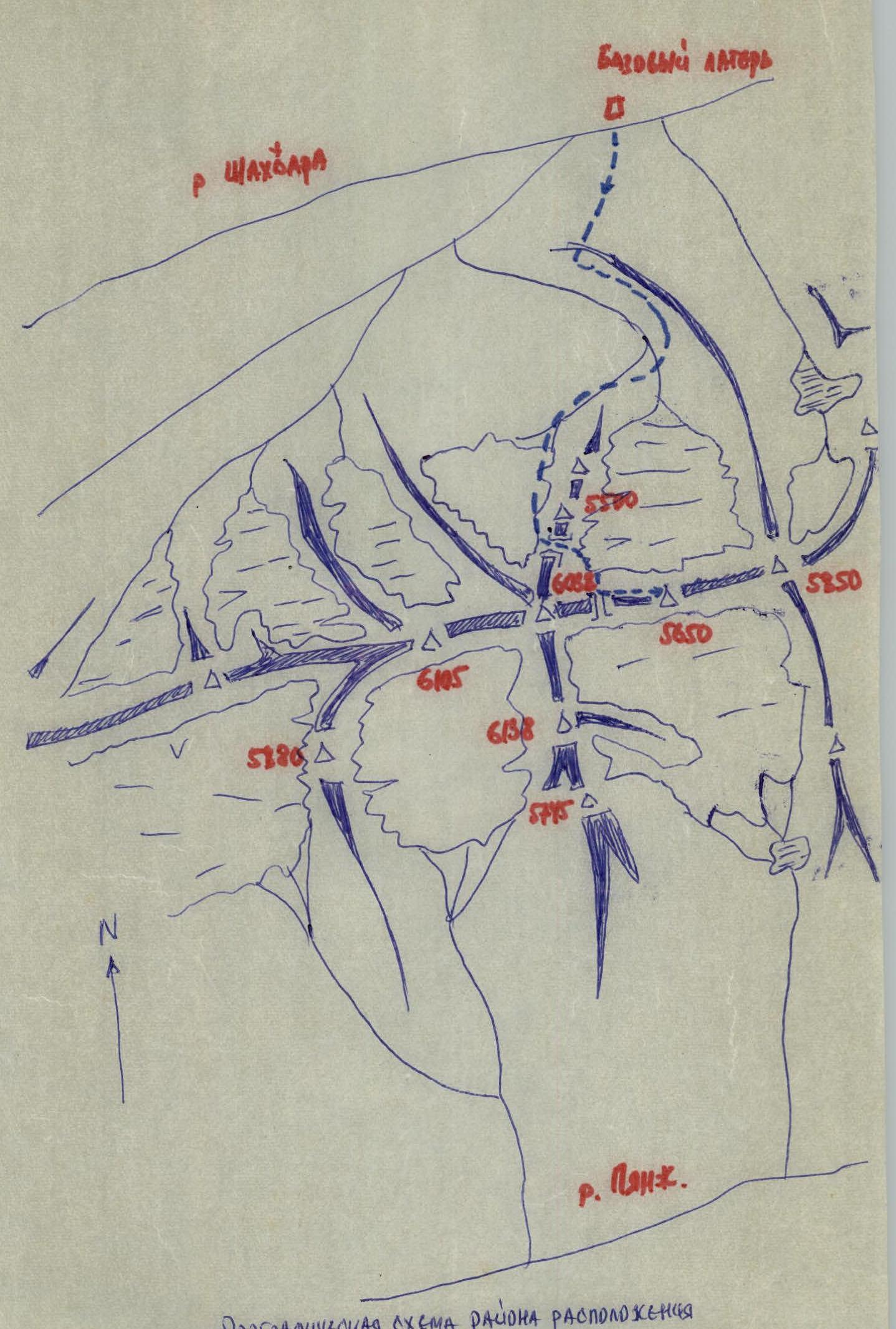 Diagram of the area where 14ος 5745, 6138, ED38, GIDS are located.
II. Brief description of the ascent conditions in the area
This area is one of the most remote in the Pamir. The nearest settlement, kishlak Sezhd, is two days' journey from the start of the route to the summit from the west. It takes two to three days to reach Sezhd from Osh by car along the East Pamir tract and Shakhdara valley. The distance from the base camp to Khorog is 60 km. The ascent area began to be explored in terms of alpinism only in 1974 by army climbers, and in 1975 the first ascent was made to p. Luknitskogo via the North face along the route of 5B cat. sl. (leader Nekrasov V.P.). In 1976, an expedition of climbers worked here again, traversing the six-thousanders of the area, led by Starlychanov V., and also made the first ascent via the northern ridge of p. Baykonur 6038 and the first ascent to peak 5650 m (duo Nekrasov V.L., Gorodetskii V.I.), described in this ascent report.
The area has significant glaciation both from the north of the ridge and from the south, especially in the area of the six-thousanders p. Vooruzhennykh Sil, p. Baykonur, and p. Marshal Grechko. All routes are combined, ice, snow, rocks, and require the use of the entire arsenal of mountaineering techniques. Weather conditions in this area in July-August favor ascents. At this time, there is mainly good stable weather.
III. Reconnaissance
The reconnaissance of the route along the western ridge of the summit 5650 m was carried out during August 15–17, 1976, during the organization of the assault camp at the saddle of v. 5500 under the leadership of Starlychanov V.D. Observation of this route was continued from August 21 to August 25 from the saddles 5100 and 5200 (observation camp). As a result, the ascent route to the summit 5650 m was determined and a tactical plan was developed. The delivery of food and some equipment to the saddles 5100 and 5200 was made during the organization of the assault camp at v. 5500 and the observation camp at the saddle 5200.
IV. Tactical plan of the ascent
The ascent plan assumed the saddle 5200 (observation camp) as the starting point. On August 25, Starlychanov V.D.'s group left the observation area and established direct communication with the base camp. The observation camp was to be relocated to the saddle 5100 by August 28 (the time required for Starlychanov V.D.'s group to ascend to p. Baykonur 6038). Therefore, the duo Nekrasov V.L. and Gorodetskii V.I. were to make the first ascent along the western ridge to the summit 5650 m and relocate the observation camp to 5100 by August 28.
The duo started the route at 6:00 on August 26, 1976, from the saddle 5200 m. Moving along the western ridge with alternating overcoming of rocky "gendarmes" took 4.5–5 hours. At 11:00, the summit was conquered. The descent from the summit along the ascent route took 2–2.5 hours. The next day, the observation camp was moved to the saddle 5100 m, and on August 28, the first ascent of the northern counterfort of Baykonur (6038) began by the duo Nekrasov V.L. and Gorodetskii V.I.
VI. Additional information about the ascent
When starting the route, the group had the following equipment:
- main rope — 1 x 40 m;
- auxiliary rope 5 mm (expendable) — 25 m;
- rock pitons (universal, channel) — 15 pcs;
- ice pitons (VUSPS) — 2 pcs;
- ladders — 3 pcs;
- rock hammers — 2 pcs;
- ice axes — 2 pcs;
It takes about 2 hours to reach the glacier from the upper reaches of the Jarh valley via the ice tributary through three ridges of the ancient moraine. Then 3–3.5 hours of movement to the saddle between the summit 5500 and 6038 (Baykonur). The height of the saddle is 5100 m. Descent from the saddle to the right branch of the glacier and ascent to the saddle 5200 between the summits 5650 m (Tespara) and 6038 (Baykonur) takes another about 3 hours. Overnight stay at the saddle. The total ascent time from the base camp in the upper reaches of the Jarh valley is about 8–9 hours of continuous movement. The overnight stay location is the starting point of the ascent to the summit 5650 m (Tespara). The duo started the route on August 26 at 6:00. The total route length is about 800–850 m, with a height difference of about 450 m. Initially, movement along the snow-rock ridge with simultaneous and alternate belay — about 400–450 m. The ridge is heavily destroyed, with many loose rocks. Movement directly along the ridge with ascent and descent along low (up to 20 m) "gendarmes". Climbing is easy, местами среднее. Belay through ledges. The first key point of the route is a "gendarme" about 80 m high. The ascent to the "gendarme" is carried out from the right (in the direction of movement) side along a vaguely expressed chimney. Overcoming the chimney is done with piton belay (5–6 pitons). Climbing is of moderate difficulty. Then about 150 m of movement along the ridge with individual "gendarmes" 10–15 m, which are overcome head-on. And here is the main key point of the route — the summit tower, about 100 m high. The average steepness is 80°, with overhanging sections in the upper and middle parts. The ascent to it is carried out slightly to the right (in the direction of movement) of the center, along a crack with overhanging rocks. The first 40 m — straight up with an exit to a small ledge above the crack. When passing the first rope, 7–8 pitons were driven (universal, channel). Climbing is of medium, местами high difficulty. The second rope — 40 m, traverse to the left (in the direction of movement) 2–3 m with subsequent passage of a section of overhanging rocks (2–3 m) with an exit to a narrow ledge, along which movement is first to the left, then up, exit to a wide ledge of the summit tower. Overcoming the section corresponding to the second rope requires complex climbing with the use of LADDERS. 8–9 pitons were driven. The third rope — climbing of moderate difficulty with alternate belay with an exit to the summit tower. Then another 30–40 m of movement along the wide ridge — exit to the summit 5650 m. The descent from the summit is carried out first in the direction of p. Luknitskogo (to the east) about 100 m. Then two sports ropes on scree ledges along the southern slopes of v. 5650 m. Then movement along the ledges leads to the base of the summit tower. Further descent to the saddle 5300 is carried out along the ascent route. The total ascent time to the summit 5650 m from the pass 5200 between the summits 5650 m (Tespara) and 6038 (Baykonur) took 4.5–5 hours for the duo, descent time 2–2.5 hours. The height of the summit (5650 m), technical difficulties encountered mainly in the upper part of the route (in the height range from 5400 to 5650 m), allow classifying this route to the summit 5650 m as a route of 4A cat. sl.
TABLE
main characteristics of the ascent route
Ascent route: summit 5650 m (p. Tespara) via the western ridge. Height difference of the route — 450 m. Route length — 800 m. Number of climbing hours (ascent in a duo) – 4.5–5.0 hours. Route steepness 45°. Length of complex sections of the route (from 70° to 90°) — 100 m. Number of driven pitons — rock — 20.
| Date | Section number | Average steepness (°) | Section length (m) | Characteristics of sections and conditions of their passage | Weather | Passage time (hours) | Rock pitons | Ice pitons | ||
|---|---|---|---|---|---|---|---|---|---|---|
| By relief character | By technical difficulty | By method of overcoming and belay | ||||||||
| August 26, 1976 | 1 | 30–40° | 400–450 | Snow-rock ridge | Easy, местами среднее | Simultaneous movement, belay through ledges | Clear | 0.5 hours | - | - |
| 2 | 60–70° | 80 | "Gendarme", rocks | Moderate difficulty, местами трудное | Movement with piton belay | Clear | 1.0 hour | 5–6 | ||
| 3 | 15° | 150 | Rocky ridge | Easy climbing | Simultaneous movement. Belay through ledges | clear | 0.4 hours | |||
| 4 | 90° | 100 | Rocky wall | Difficult climbing | Movement with alternate piton belay with use of ladders | clear | 2.0–2.5 hours | 15–17 | ||
| 5 | 20–25° | 40 | Wide ridge | Easy climbing | Simultaneous movement | clear | 0.1 hours |
Team members: GORODETSKII V.I. NEKRASOV V.L. Team coach MSМК NEKRASOV V.P.
 Photo 1. Start of the route to V 5650.