DONETSK REGIONAL COUNCIL OF DSO "AVANGARD" ALP CLUB "DONBASS"
REPORT
on the first ascent to the South Tajikistan peak (6300 m) via the right part of the eastern wall Donetsk, 1972
I стр.
§ 1. Geographical location and sports characteristics of the South peak of Tajikistan
The South peak of Tajikistan is located in a spur of the Shakhdarin ridge, south of the main peak of Tajikistan (6565 m).
On the eastern side, the peak is bounded by the Dridzh Zapadny glacier, and on the west by the Rovini glacier.
The object of the ascent - the eastern wall of South Tajikistan - towers 1300 meters above the upper reaches of the Dridzh Zapadny glacier. Despite the fact that several mountaineering expeditions have visited the area (1959 - Tikhonravov, CSKA; 1962 - Savvon, Burevestnik; 1964 - Lithuanians, etc.), there were no attempts to ascend the South peak of Tajikistan due to its complexity and remoteness.
The eastern wall is a series of sheer bastions 400-500 m high, transitioning into a continuous wall of solid rocks on the right, generally too steep to hold snow.
To clarify the ascent route and descent path, a series of reconnaissance exits were made, including:
- ascent to the opposing peak LGU (6222 m);
- ascent to the Main peak of Tajikistan via the eastern ridge (Savvon's route).
The reconnaissance results showed that the eastern wall has several very complex, logical, and safe ascent options: via the left, right, and central bastions, as well as the left and right parts of the wall.
There are no ascent routes to the peak below category 5B, in our opinion.
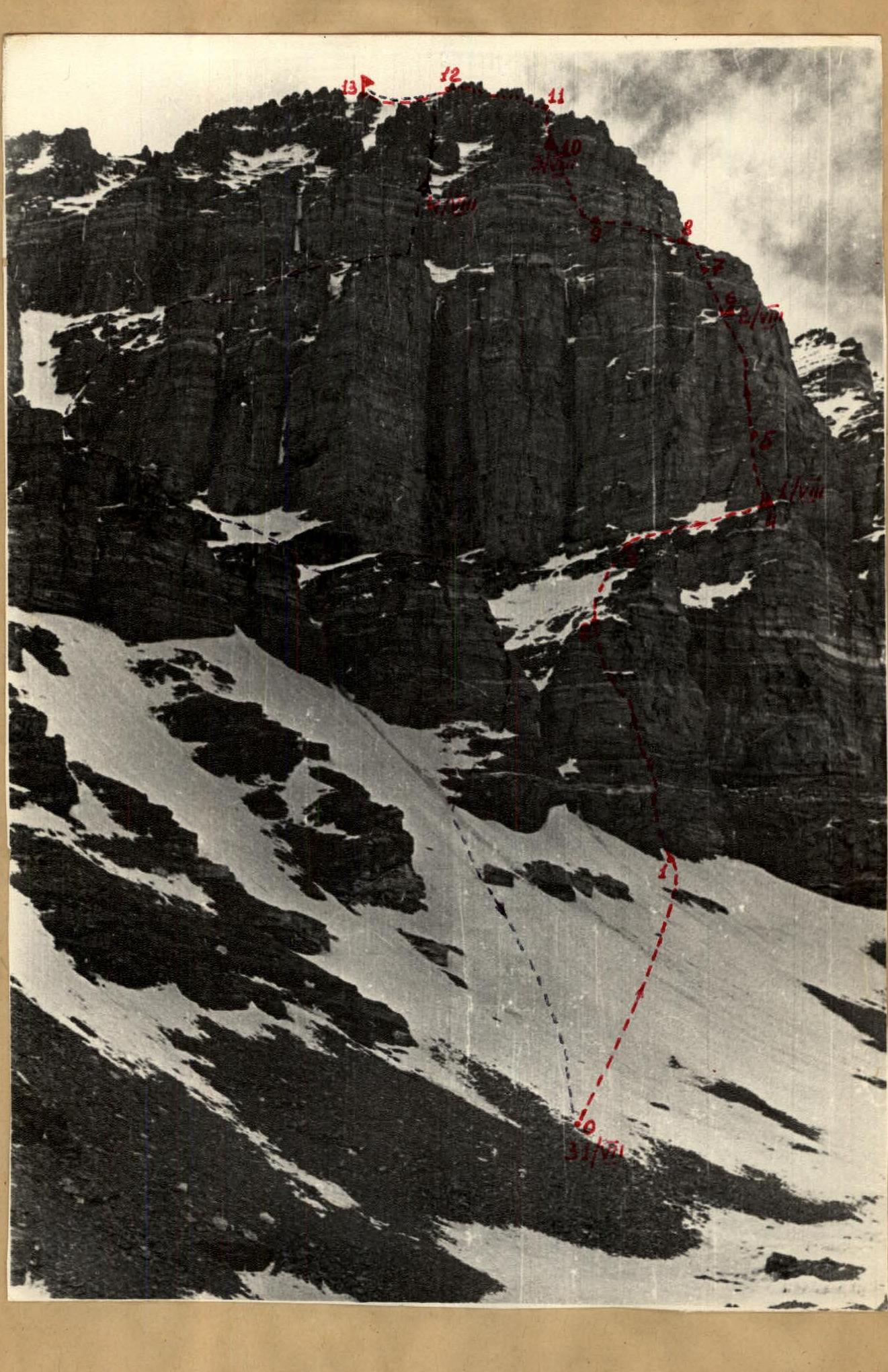
As a result of reconnaissance and three days of observation from the lateral moraine in the upper reaches of the Dridzh Zapadny glacier, the ascent route via the right part of the eastern wall with an exit to the southeast ridge was finally chosen.
At the same time, the central bastion of the peak became the object of ascent for the team of masters from the "Donbass" alpclub (led by V.V. Laukhin), entered in the USSR championship.
§ 2. Brief description of the ascent conditions in the area of the South peak of Tajikistan
The 1300-meter ascent route can be divided into four sections: a) from the starting camp on the coastal moraine in the upper reaches of the glacier to the snow shelf under the bastion (right) - I rock belt. The rocks are difficult, smoothed, of the "ram's forehead" type. b) from the snow shelf upwards - 350 m sheer - II rock belt: monolithic, difficult rocks requiring all techniques of free and artificial climbing: c) II rock belt with a height difference of 200 m has varying complexity sections. Rocks of medium difficulty alternate with short (20-25 m) monolithic walls, sometimes covered with ice and water. d) southeast ridge leading to the South peak of Tajikistan - rocks of medium difficulty and snow.
Climatic conditions in this area in July and August, according to past expeditions, are generally favorable for climbing.
In 1972, from July 24 to August 3, stable, sunny weather prevailed in the Dridi gorge. The difficulties encountered when overcoming the rock belts, especially on the last section - the pre-summit ridge - were strong southwesterly winds.
The peak of Tajikistan is approximately 20 km from the Pyanj river valley. The group took 2 days to approach the starting camp on the Dridzh Zapadny glacier with a 12-day load.
§ 3. Reconnaissance exits
To observe the state of the eastern wall and clarify the optimal ascent route, a series of reconnaissance exits and ascents were made.
- Participants of the ascent, Sapoga E. and Bondarets S., conducted three-day observations of the eastern wall using 8x binoculars and a 30x telescope.
- Together with the participants of the USSR championship (Laukhin V.V.'s group), Sapoga and Bondarets made a reconnaissance detour of the South Tajikistan peak (from the starting camp to the left) of the western and northwestern slopes of the peak to determine possible descent paths.
4 стр.
- On July 28, a group of climbers from the Donetsk gathering led by Sapoga made an ascent to the opposing peak LGU (6222 m), from which the upper part of the route is clearly visible.
- On July 26-29, two participants of the first ascent, Radashkevich and Pavlyuchenko, as part of the Donetsk gathering group, made an ascent to the Main peak via the eastern ridge (Savvon's route), from which the profile of the chosen first ascent route is clearly visible.
All participants of the ascent had prior high-altitude acclimatization on peaks above 6000 m, gained during two weeks of climbing in the Kyshty-Dzherob gorge from the " Vysotnik" alpine camp base.
§ 4. Organizational and tactical plan for the ascent
The ascent to the South peak of Tajikistan via the eastern wall was organized by the "Donbass" alpclub and the regional council of DSO "Avangard" as part of gatherings held in 1972 in the Southwestern Pamir after completing ascents through collective vouchers at the "Vysotnik" alpine camp (gathering leader - Honored Coach of the Ukrainian SSR, Sivtsov B.G.).
The object of the ascent was chosen jointly with the team of masters from the "Donbass" alpclub, entered in the USSR championship since March 1972, based on photographs and consultations with Savvon's group. Due to the anticipated technical complexity and height (6300 m), the group was planned to consist of 4 people with long-standing climbing experience, excellent physical and technical preparation.
The group consisted of:
- Sapoga Evgeny Aleksandrovich - ascent leader, born 1949, CMS in mountaineering, Master of Sports in rock climbing.
- Radashkevich Evgeny Aleksandrovich - participant, born 1946, DSO "Spartak", CMS in mountaineering, 1st sports category in rock climbing.
- Bondarets Stanislav Afanasievich - participant, born 1939, member of DSO "Avangard", CMS in mountaineering, 2nd sports category in rock climbing.
- Pavlyuchenko Valery Nikolaevich - participant, born 1940, member of DSO "Avangard", 1st sports category in mountaineering and 1st sports category in rock climbing.
All planned participants completed the ascent and reached the summit.
All participants, in preparation for the technically complex ascent above 6000 m:
- engaged in year-round training in their section;
- participated in several rock climbing competitions and cross-country orienteering in 1972;
- completed a series of qualification ascents of category 4A, 5B on the Southwestern Pamir, in the Kyshty-Dzherob gorge, between July 1 and July 20, 1972.
The tactical plan for the ascent was refined in the Dridi gorge after reconnaissance exits and observations:
- Approach to the starting camp from Isor on July 24-25.
- July 26-28 - organization of observations of the eastern wall of the peak.
- July 26-29 - reconnaissance exits and qualification ascents of group participants in the Dridi gorge.
- July 30 - rest day.
- On the first day of the ascent, process the section from the starting camp to the snow shelf on the I rock belt.
- On the second day, pass the I rock belt (sections R1-R4).
- On the third and fourth days, pass the II rock belt. Based on preliminary observations, a hanging (hammock) overnight stay is possible. Passing the II rock belt (350 m) is the key part of the route, requiring equipment for creating artificial footholds and belays: ladders, platforms, piton hooks.
- Fifth day of ascent - overcome the II rock belt, set up a bivouac under the southeast ridge of South Tajikistan.
- Sixth day of ascent - ascend to the peak, descend via the left part of the wall to the second rock belt.
- Seventh day - descend to the base camp via the left part of the wall, bypassing the bastions. Alternative descent route - via the ascent path.
- During the ascent, maintain radio contact with Laukhin's group, ascending the bastion to the South Tajikistan peak, and the observation group located in the base camp.
- The ascent group includes expedition doctor Radashkevich E.A.
- Preliminary route processing was planned for the first day of ascent - beginning of the I rock belt.
- Ropes, based on optimal climbing compatibility, were planned as:
- Sapoga - Radashkevich
- Bondarets - Pavlyuchenko
The first rope works ahead on the 1st, 2nd, and 4th days of ascent. The second rope works ahead on the 3rd and 5th days of ascent. On the 6th day, the ropes work alternately. The lead climbers in the ropes work evenly, depending on the complexity of the terrain. On the rocks of the I and II rock belts, the lead climber is belayed on a double rope, for which the group carries three main ropes of 40 m and a 60 m cordelette.
To increase the ascent pace, the ropes work as independently as possible, combining their efforts only on sections where rucksack hauling is necessary: II rock belt and sections of the I rock belt.
The planned plan was largely executed; the nature and condition of the route were correctly assessed.
There were the following deviations from the original tactical plan:
- Due to the excellent physical and technical preparation of the group participants, on the second day of ascent, they were able to quickly pass the processed section and approach the II rock belt. As a result, on the same day, they processed another 2 ropes of the II rock belt, which made it possible to avoid a hanging overnight stay on the third day.
- The descent was made with some deviations from the planned route, as they followed the tracks of the previous group (Laukhin's group).
§ 5. Order of route passage
After reconnaissance exits and ascents, on July 30, the entire group had a rest day in the starting camp. All necessary equipment, food, and fuel were brought to the starting camp the day before.
The group took food for the route at a rate of 0.6 kg per person per day for 7 days.
July 31
The Sapoga - Radashkevich rope begins processing the I rock belt. They ascended a 45° snow-ice slope (section 1) and approached the I rock belt (a rock belt cut by narrow, steep snow-ice couloirs, prone to avalanches and rockfall), and began working on the rocks. The rocks are difficult. In the middle of the rock belt, the path is blocked by a 10-meter vertical chimney - the most complex section of the I rock belt. They overcame it using ladders and led out onto a small snow shelf.
After fixing 150-meter handrails, they descended to the starting camp.
August 1
Having passed the processed section via the handrails, the Pavlyuchenko - Bondarets rope continued working on the rocks of the I rock belt (section 2). Sapoga and Radashkevich hauled up the rucksacks. At 14:00, they reached a wide snow shelf marking the end of the I rock belt.
Section 3 consists of a snow slope up to 50° with rock outcrops. In the upper part of the section, there is a 30-meter rock wall. The rocks are of medium difficulty.
Section 4 is a large inclined snow shelf. Having passed section 3 and then along the shelf to the right to its end (section 4), they approached the start of the II rock belt (first control point).
While the first rope set up a bivouac, the second rope, Pavlyuchenko - Bondarets, processed an 8-10 meter wall section, fixing two ropes of handrails.
August 2
They set out at 8:00. It was very cold. Having passed the processed section and another rope of difficult rocks to the right and upwards, they reached a small shelf. Further on, there are the key section of the route - a 250-meter sheer drop, 85-90° steep, monolithic rocks of the "ram's forehead" type with few footholds and cracks. The Bondarets - Pavlyuchenko rope organizes rucksack hauling. The Sapoga - Radashkevich rope begins working on the route.
The first climber goes on a double rope, using ladders, piton hooks, and often relying on friction, employing all rock climbing techniques.
The cracks are shallow, sealed, and hook placement is poor. Throughout the section, the first climber wears keds.
Having passed four ropes, they reached a small snow shelf. They decided to stop as daylight was fading and they were quite tired. It became very cold again. They laid out a relatively good platform and set up a tent (2nd control point).
August 3
While the Sapoga - Radashkevich rope dismantles the bivouac, the Bondarets - Pavlyuchenko rope passes another one and a half ropes (section 7).
Further on, there is a wide snow shelf - the II rock belt is finally passed! But it's not much easier ahead. The path is blocked by a 40-meter sheer rock wall (section 10). The first 7 meters have no footholds at all.
Standing on each other's shoulders and using piton hooks as footholds, they pass this section. Further on, it's easier, and they can climb using free climbing techniques. Having passed another 3 ropes of difficult rocks (section 10), they stopped under the ice-snow couloir and to the right of it for a night's stay (3rd control point).
August 4
They set out at 9:00. It was very cold, with strong winds. Initially, the path follows the couloir leading to the ridge (section 11), and then along the ridge. The rocks on the ridge are of medium difficulty, alternating with short walls (section 12). Near the peak, the ridge becomes snowy (section 13). The technical difficulty decreases, but climbing becomes increasingly harder due to the altitude.
At 14:00, they reached the peak, which is a small rocky platform. A cairn built by Laukhin's group marks the end of their ascent to the peak.
After resting, at 15:00, they began their descent. They descended following Laukhin's group's tracks: initially with alternating belays for 30 meters along the ridge (section 13), then turned right, made three sports descents and two dülfers straight down, and landed on Laukhin's group's bivouac site.
August 5
They set out at 9:00. Five dülfers straight down and they landed on a snow shelf under the rock belt.
II стр.
Further on, three dülfers and along the rocks of the II rock belt and Laukhin's group's bivouac on a rock shelf under the II rock belt.
From here, another three dülfers and two sports descents, after which they reached a snow-ice slope leading to the Dridzh Zapadny glacier.
Overall assessment of participants' actions
As mentioned earlier, the group had a long-standing climbing partnership, having completed several routes of the highest category on the Caucasus. This was reflected in the quality of the ascent.
All participants acted in harmony and organization. During the ascent, they demonstrated great cohesion, self-discipline, endurance, attention, and respect for each other.
Technically and tactically, the participants are excellently prepared.
Route assessment
The ascent participants assess the route as category 5B in terms of complexity and length.
ASCENT LEADER: E. SAPOGA
TEAM COACH: B. SIVTSOV
Table
of the main characteristics of the ascent route to the South peak of Tajikistan (6300 m) via the right part of the eastern wall
Height difference: 1300 m
Including the most complex sections: 400 m
Average steepness of the route: 60°
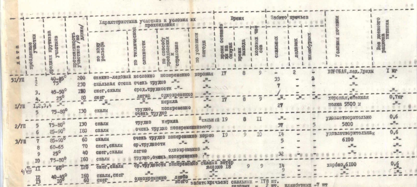
| Date | Sections | Distance (m) | Steepness | Characteristics of sections and conditions of passage | Time (h) | Pitons hammered: rock | ice | piton | Conditions of overnight stay | Weight of daily food (kg) |
|---|---|---|---|---|---|---|---|---|---|---|
| July 31 | 200 | 40-45° | snow-ice, несложno, попеременно, хорошая | 17 | 8 | 9 | 2 | хорошая, лёд Дриды | 1 | |
| 230 | 75° | скальная стена, очень трудно | 33 | 7 | ||||||
| 3. | 190 | 45-50° | снег, скалы, средней трудности | |||||||
| 4. | 80 | 25° | снег, легко, одновременно | |||||||
| August 1 | 1, 2, 3, 4 | перила | ||||||||
| 5 | 130 | 75-80° | скалы, трудно, попеременно, очень трудно | 17 | 8 | 9 | 27 | хорошая, снежная полка 5500 м | 0.7 | |
| 5 | 130 | 75-80° | скалы, трудно, перила | 19 | 8 | 11 | удовлетворительно | 0.6 | ||
| August 2 | 6 | 180 | 85-90° | скалы, очень трудно, попеременно, ветер | 37 | 5 | 5800 м | |||
| August 3 | 7 | 60 | 85-90° | скалы, очень трудно, попеременно, хорошо | 19 | 9 | 10 | 14 | удовлетворительная | 0.6 |
| 8 | 70 | 60-65° | снег, скалы, средней трудности | 5 | 6100 м | |||||
| 9 | 40 | 25° | снег, скалы, легко, одновременно | 32 | ||||||
| 10 | 160 | 75-80° | скалы, трудно, очень попеременно | |||||||
| August 4 | 11 | 120 | 60° | снег, скалы, средней трудности, попеременно, сильный ветер, холодно | 18 | 9 | 9 | 14 | хорошо, 6100 м | 0.6 |
| 12 | 160 | 40-45° | скалы, снег, легко, одновременно | 9 | ||||||
| 13 | 100 | 60° | снег, перила | |||||||
| Total pitons hammered: | rock 178 | ice 2 | piton 7 |
DESCENT: initially 30 m along the ridge, then from the ridge to the right (using sports descents and dülfers) under the I rock belt. Then to the right along the rocks of the I rock belt using sports descents, further five dülfers and exit under the II rock belt. Two dülfers and three sports descents on the I rock belt lead to the Dridzh glacier. ASCENT LEADER: