Ascent Passport
I. Ascent class — 74 2. Ascent area — South-West Pamir, Shakhdarin Range, southern spur 3. Peak, its height and route — peak Skalniy via the southern counterfort 4. Estimated difficulty category — 4B 5. Route characteristics * height difference — 500 m * average steepness — 5.945 * extent of sections 6. Number of pitons driven: rock, ice * for belaying — 21 * for creating belay stations — 2 7. Number of climbing hours — 10 hours 8. Number of bivouacs and their characteristics — no bivouacs 9. Full name of the leader and participants, their sports qualification: * Zybin Alexander Nikolayevich — 2nd sports category * Tinin Yuri Pavlovich — 1st sports category * Hankevich Andrey — 1st sports category * Shibanov Alexander Viktorovich — 2nd sports category 10. Team coach 11. Date of departure and return
The ascent was made by the MGS DSO "Spartak" group under the leadership of Zybin A. N.
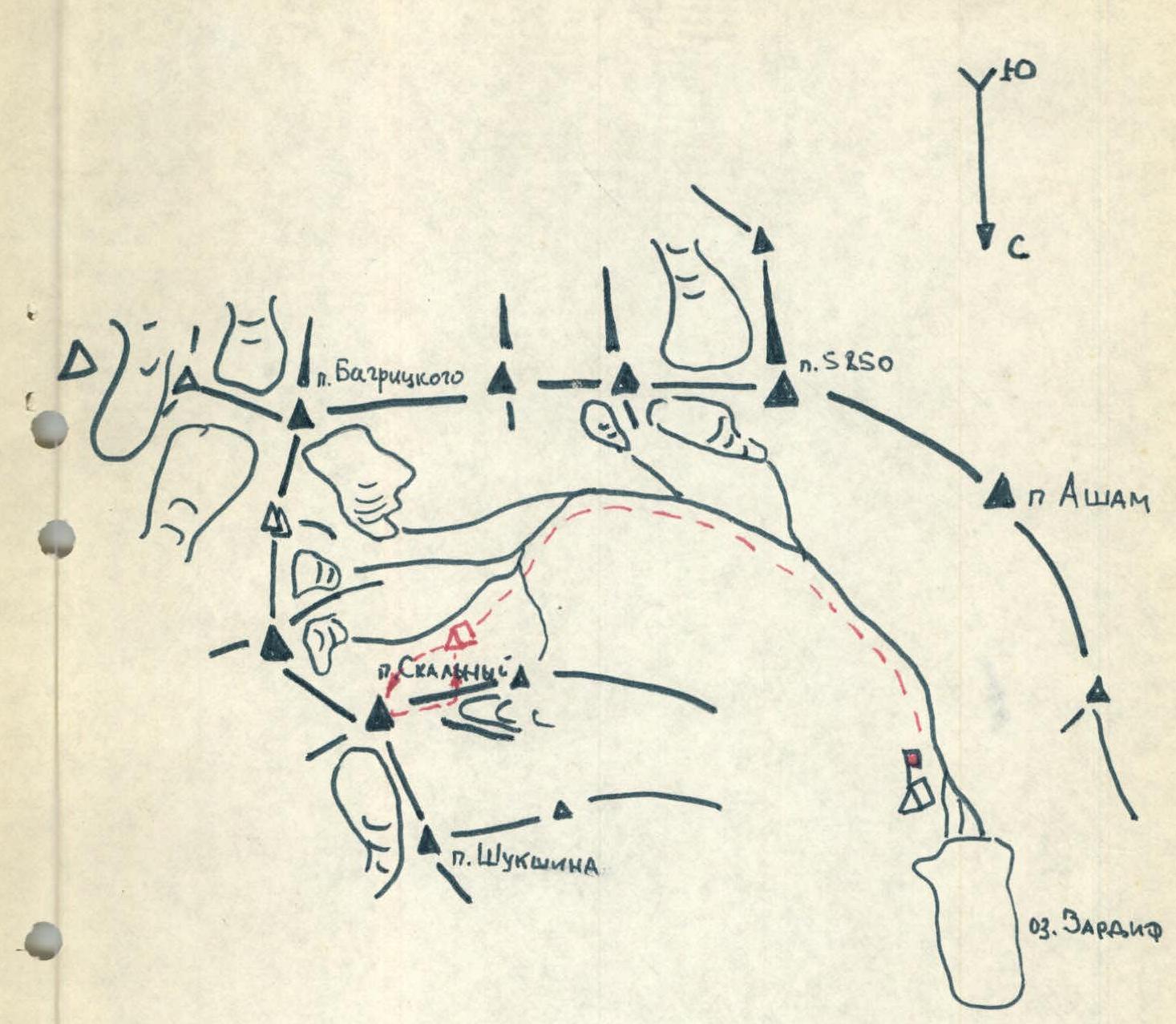
Ascent Area
p. Skalniy is located in the southern spur of the Shakhdarin Range, branching off from v. 5700 (p. Bagritskogo) / area of p. P. Luknitskogo. The upper quarter of the p. Skalniy massif and all southern slopes of the massif have a rocky structure, without snow cover, in some areas the rocks are covered with ice. In the lower part, the southern slopes are smoothed rocks of the type "ram's foreheads", in the middle part — rocks are destroyed, alternating with small ledges, in the upper third of the massif — the structure of the rocks is block-like.
The height of the peak is approximately 5 m.
Route Description
- The beginning of the route is under the southern counterfort on the southern slopes of the peak, representing alternating plate-like rocks, to the right of extensive dark flows with a waterfall. Ascent via a scree couloir (15 min, 70 m).
- At the beginning of the snow patch in the couloir, transition to the left side of the couloir. Rocks of medium difficulty, alternating with ledges. Simultaneous movement (60–80 m). Exit to the left onto a vaguely defined ridge shoulder. Cairn.
- Wall 50 m (70–75°). Difficult section. Piton belay. 30 m from the foot of the wall — a small ledge — a convenient place for organizing belay.
- Further, a destroyed ridge 200–240 m, between two rockfall-prone couloirs.
- Further, 30 m of rocks of medium difficulty, straight up — exit to a horizontal ledge in front of the wall. On the left part of the ledge on the shoulder — a cairn.
- To the left of the shoulder, 5–7 m up leads a chimney 15 m. Difficult section! Piton belay. Exit to the ridge of the counterfort. Up the ridge 30 m to the wall.
- Further, to the left 7–10 m to the turn behind the ridge. From here, straight up on inclined slabs 60°. Piton belay. Further along the ridge 60 m to a small shoulder and sharp inclined slabs on the ridge in the area of yellow rocks.
- Bypass the sharp slabs to the right and up. Exit to a small snowy shoulder. Further up, a wall 20 m and again a shoulder.
- Pre-summit pyramid. Bypass 10 m to the right, further up the wall. Piton belay.
- Further, a steep, heavily destroyed ridge 4 ropes. Exit to the summit.
- Descent from the summit along the northwestern ridge. Descent goes along snowy slopes, then to a small snowy plateau, and to the right onto scree slopes — descent via scree couloirs to the bivouac on the "onion" meadows.
The group took 10 climbing hours to complete the route. 23 rock pitons were driven on the route. The nature of the rocks allowed for reliable belaying through outcrops in some cases.
The group evaluates this route — 4B cat. difficulty.

Group Equipment
- main ropes — 2 pcs. 40 m each
- rock pitons — 20 pcs.
- expendable rope — 5 m
- "Vibram" boots — 3 pairs
- "Otricon" boots — 1 pair
- rock hammer — 3 pcs.
Participants and the ascent leader had experience of climbing routes in previous seasons:
- Sakharnaya Golova — 5A
- Ural — 5A
- Dutandon — 5A
- Ukyu — 4B
- Central Dolomites — 4B
- Jinatar — 4B
Section Characteristics
| Designation | Average Steepness | Length | Terrain Type | Difficulty | Condition | Weather Conditions | Rock Pitons | Ice Pitons | Bolt Pitons |
|---|---|---|---|---|---|---|---|---|---|
| R1 | 40° | 70 m | couloir | medium | monolithic rocks | clear | – | – | – |
| R2 | 50° | 60–80 m | ledges | medium | – | – | – | – | – |
| R3 | 70–75° | 50 m | wall | difficult | – | – | 6 | – | – |
| R4 | 40° | 200–240 m | ridge | medium | destroyed ridge | – | 5 | – | – |
| R5 | 50° | 40 m | ledges | – | monolithic, destroyed | – | 4 | – | – |
| R6 | 80° | 50 m | chimney | difficult | monolithic | – | 3 | – | – |
| R7 | 60° | 70 m | slabs | difficult | monolithic | – | 3 | – | – |
| R8 | 55° | 45 m | wall | difficult | rocks, snow | – | 3 | – | – |
| R9 | 75° | 20 m | – | – | monolithic | – | 3 | – | – |
| R10 | 70° | 160 m | ridge | medium | destroyed ridge | – | 2 | – | – |
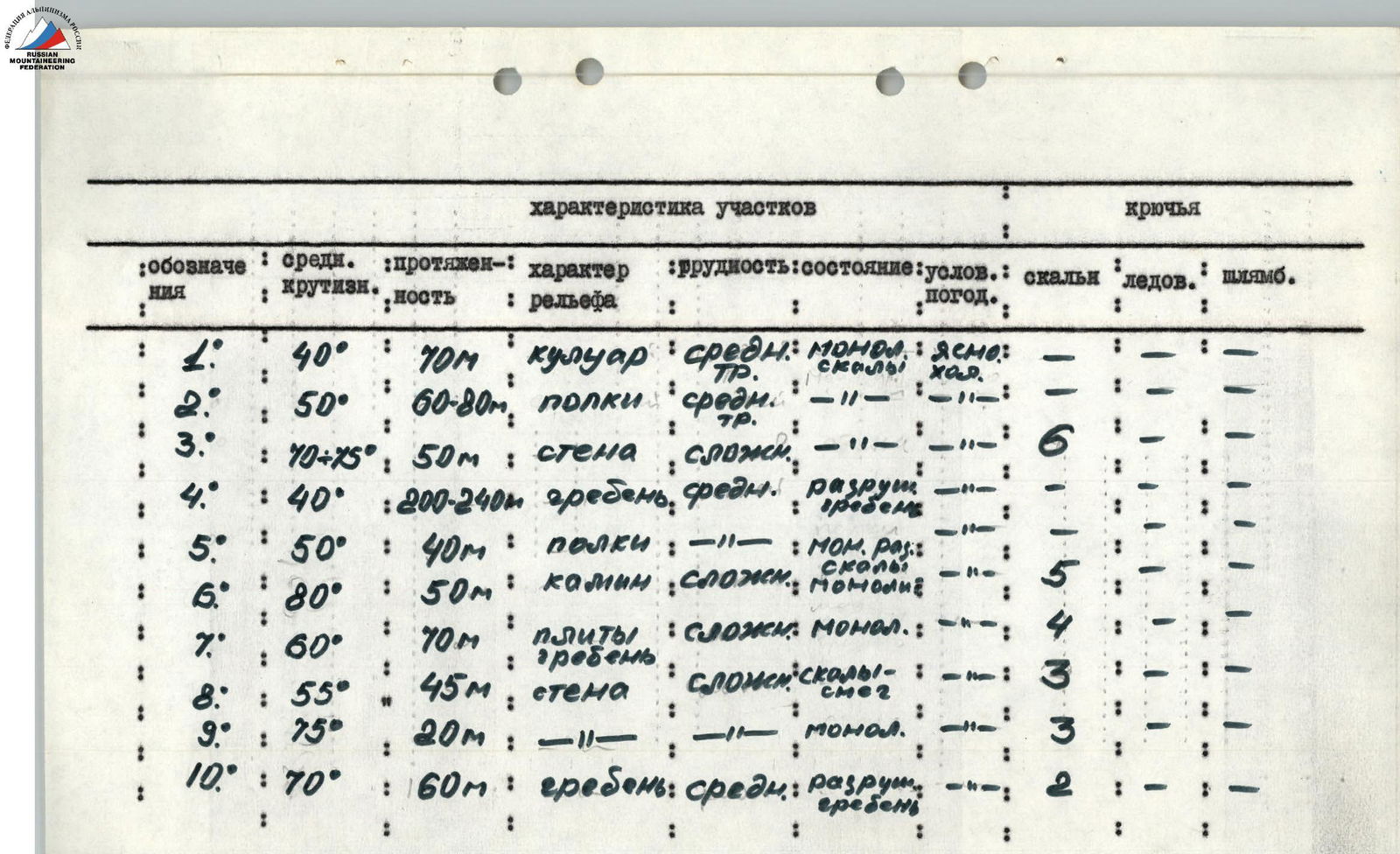
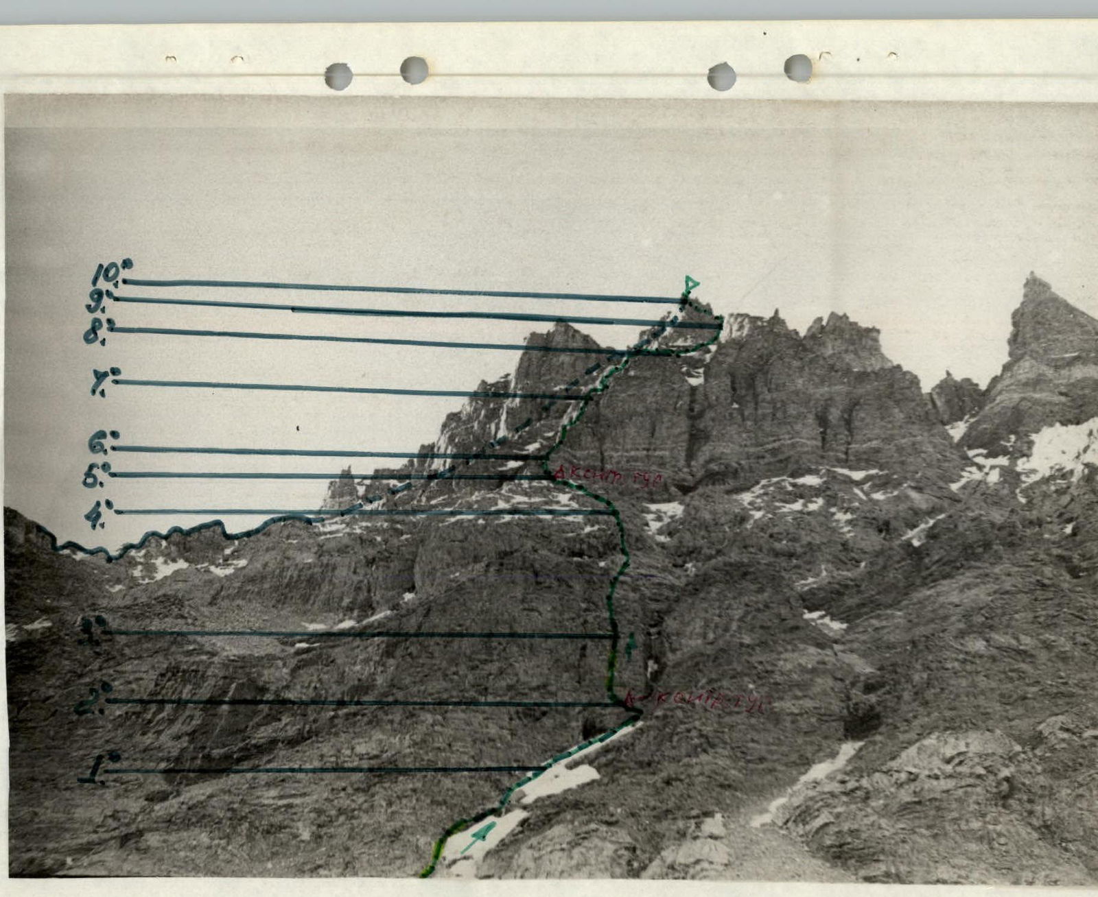
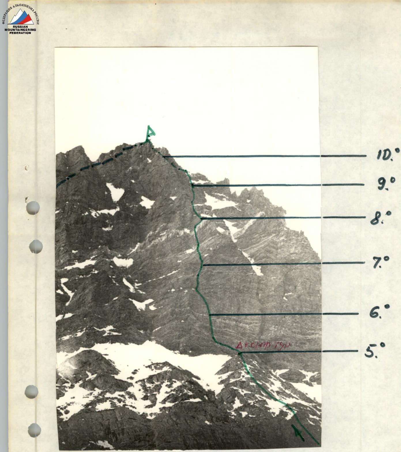
Photo scheme of the ascent to p. Skalniy via the southern counterfort
Map-scheme of the ascent area