Ascent Logbook
I. Ascent class — high-altitude technical.
II. Ascent area — Southwest Pamir range, Shakhdarin range.
-
Peak, its height, ascent route — Moscow Pravda (South) peak, 5739 m, right Northeast edge.
-
Proposed difficulty category — 5B.
-
Route characteristics:
- Height difference — 1200 m
- Length of 5–6 sections — 910 m
- Average steepness — 63°
-
Pitons driven:
- for belaying, including for creating ITO:
- rock — 221
- ice — 4
- bolt — 7
- for belaying, including for creating ITO:
-
Number of climbing hours — 54 hours.
-
Number of overnight stays and their characteristics. Four overnight stays:
- three lying down
- one sitting
-
Surname, name, patronymic of the team leader, participants, and their qualifications:
- Abramov Alexander Fedorovich, Candidate Master of Sports
- Knyazev Vladimir Ivanovich, 1st sports category
- Lunyakov Grigory Evgenievich, 1st sports category
- Prjanikov Sergey Germanovich, Candidate Master of Sports
-
Team coach — Popenko Yuri Stepanovich.
-
Date of departure on the route — July 22, 1978. Date of return — July 26, 1978.
Brief geographical overview and mountaineering characteristics of the area
The Moscow Pravda peak massif is located in the southeastern part of the Shakhdarin range spur — one of the Southwest Pamir ranges.
Southwest Pamir occupies a territory bounded by the Pyanj River to the southwest and the Bartang River to the north. The general orientation of the ranges is latitudinal. The Rushan, Shugnanskiy, Shakhdarin, and, lying to the east, South Alichur ranges stretch from west-southwest to east-northeast. The highest peaks of the Shakhdarin range are: Karl Marx, 6726 m, Tajikistan, 6565 m, Engels 6510 m. The total length of the range is about 105 km. The Vrang pass divides it into eastern and western parts. The area is home to the largest glaciers of Southwest Pamir: Ningar, Zugvand, Kishty-Jerob, and others. The glaciation of the Shakhdarin range occupies an area of 250 km², which is significant for these latitudes. The snow line is at an altitude of about 5000 m.
The area is usually characterized by stable anticyclones in July-August, resulting in a large number of sunny days. 1978 was no exception. Only in early July until the 10th:
- there were rains below;
- snow above 4000 m. Then, stable warm weather set in.
The geology of the area is characterized by a powerful granite platform raised to a significant height. The northern and northeastern slopes of the peaks are composed of large-block granites with interlayers of schists, gneisses, and marbles, which gives many peaks a transversely striped color (typical of the Nikolaadze, TGU, and Engels peaks).
In sports terms, Southwest Pamir is one of the most interesting regions of the USSR.
More than 10 high-class routes have been completed here, which have taken prize places in the USSR championship at various times, including on the Moscow Pravda peak. The Eastern wall of the TGU peak, climbed this season by two teams competing in the USSR championship, is of great interest to mountaineers.
The area is also popular due to its relative accessibility, eliminating the need for a helicopter. Almost all expeditions travel from Osh — Kyrgyz SSR by car and are on the road for 1–2 days. Our team arrived by car from Alma-Ata, taking 4 days (ZIL-130 cars) to reach the border post Langar and then the abandoned kishlak Derg (500 m higher up the slope).
From the Derg kishlak to the base camp at 3800 m in the Kishty-Jerob valley, there is a good trail. Cargo transportation is carried out by a caravan of donkeys. Donkeys can be found in the kishlaks:
- Zong,
- Isor,
- Langar (5 rubles per trip). The journey with a caravan takes 4–5 hours, without a caravan and with heavy backpacks 3.5–4 hours.
Route selection
Upon arrival in the expedition area, while undertaking acclimatization climbs and training ascents, we constantly searched for new paths to the surrounding peaks. The Moscow Pravda peak was chosen as the object of ascent.
The Moscow Pravda peak massif is a long (up to 15 km) ridge, sharp and highly elevated (6075 m), and is the southeastern part of the Shakhdarin range spur, stretching from the Engels peak.
The entire massif consists of several peaks: 5491 m, 6075 m, 6000 m, 5739 m.
To the east and northeast, the ridge drops with steep walls (1200–1500 m) with numerous edges, two of which had not been climbed before.
Our choice fell on the northeastern edge, leading to the ridge to the right of the Moscow Pravda (South) peak.
The route is logical and unambiguous, separated by clearly defined couloirs and edges from neighboring routes (on the wall of the Moscow Pravda (South) peak — the Romanenko route and the Northeast wall on the Moscow Pravda peak — the Snesarev route), climbed earlier. Upon visual observation, it appears to consist of six major sections:
- the wall from which the edge drops to the glacier
- a monolithic edge
- a steep ascent of the edge
- a rock-snow edge
- a rusty, sheer wall
- a rock-ice slope leading to the pre-summit ridge.
Preparation and ascent tactics
By the time of the first ascent, all team members had completed a series of ascents from 3rd to 5th category difficulty and were in excellent physical condition.
The route was observed:
- during preliminary ascents,
- by a special observation group using 8x binoculars.
As a result of studying the route, a tactical plan for the ascent was developed, and a safe path to the route was determined.
It was decided to ascend in two rope teams:
- Abramov A.F. Lunyakov G.E.
- Knyazev V.I. Pryannikov S.G.
The participants in the rope teams had experience of joint ascents of 5A and 5B category difficulty during the same season. For reliable belaying and convenience, 3 × 40 m ropes were taken. The first climber used a double rope. Four overnight stays were planned on the route:
- under the monolithic edge,
- under the rock ascent of the edge,
- on the rock ascent of the edge,
- on a snow shelf above the sheer wall.
Light and calorie-rich food was selected for the ascent: mushroom and pea soups, chicken fricassee, dry milk, etc. A total of 500 g per person per day. The weight of the backpacks at the start was 14–15 kg.
The ascent to the route and passage of the lower part of the wall were planned for early morning hours when (according to preliminary observations) the danger of rockfall was minimal. Only the lower part of the route was considered dangerous in terms of rockfall.
The greatest technical difficulties were expected in the middle and upper parts of the route.
The choice of bivouac sites was determined by considerations of:
- safety,
- availability of suitable shelves,
- the expected ascent schedule.
As a result of a detailed study of the route, we concluded that daily preliminary processing of sections was necessary throughout the ascent.
The descent from the summit was planned via a 2A category difficulty route.
During the ascent, the team was under constant observation by a special observation group using 8x binoculars, consisting of:
- Master of Sports Zolotareva V.P.
- Candidate Master of Sports Aulchenko Yu.A., who were positioned at the "Babel" bivouacs. Communication was carried out using a P-147 radio station at pre-arranged times.
- Brief description of the approach to the route. The path to the route from the base camp "3800" goes up the right bank of the Kishty-Jerob River to the terminal moraine of the glacier (1 hour). The moraine is overcome directly "head-on," the stream flowing from under the glacier tongue is bypassed on the left, and the exit is made to the left side of the glacier (30 minutes). Then, along a trail to the bivouac under the Babel peak, located opposite the route (1 hour). From here, the route was observed, and supplies were cached. Then, cross the glacier under the route (30 minutes).
TABLE of main characteristics of the ascent route

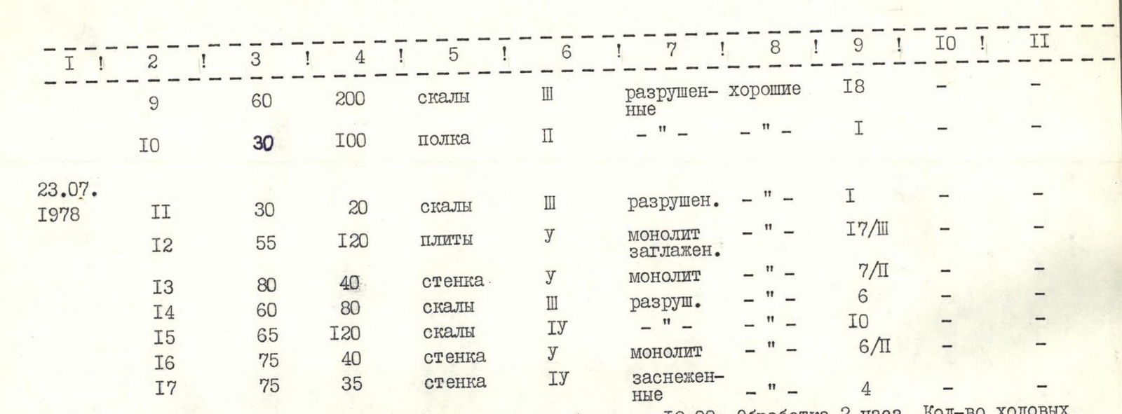
July 22, 1978. Departure from the moraine bivouac at 8:00. Stop for bivouac at 18:00. Processing — 2 hours. Number of climbing hours — 12 hours. Bivouac lying down, comfortable.
July 23, 1978. Departure from the bivouac under the edge at 9:00, stop for bivouac at 18:00. Processing — 1 hour. Number of climbing hours — 10 hours. Bivouac lying down, comfortable.
July 24, 1978. Departure from the bivouac under the ascent at 9:00, stop at 20:00. Number of climbing hours — 11 hours. Bivouac semi-reclining.

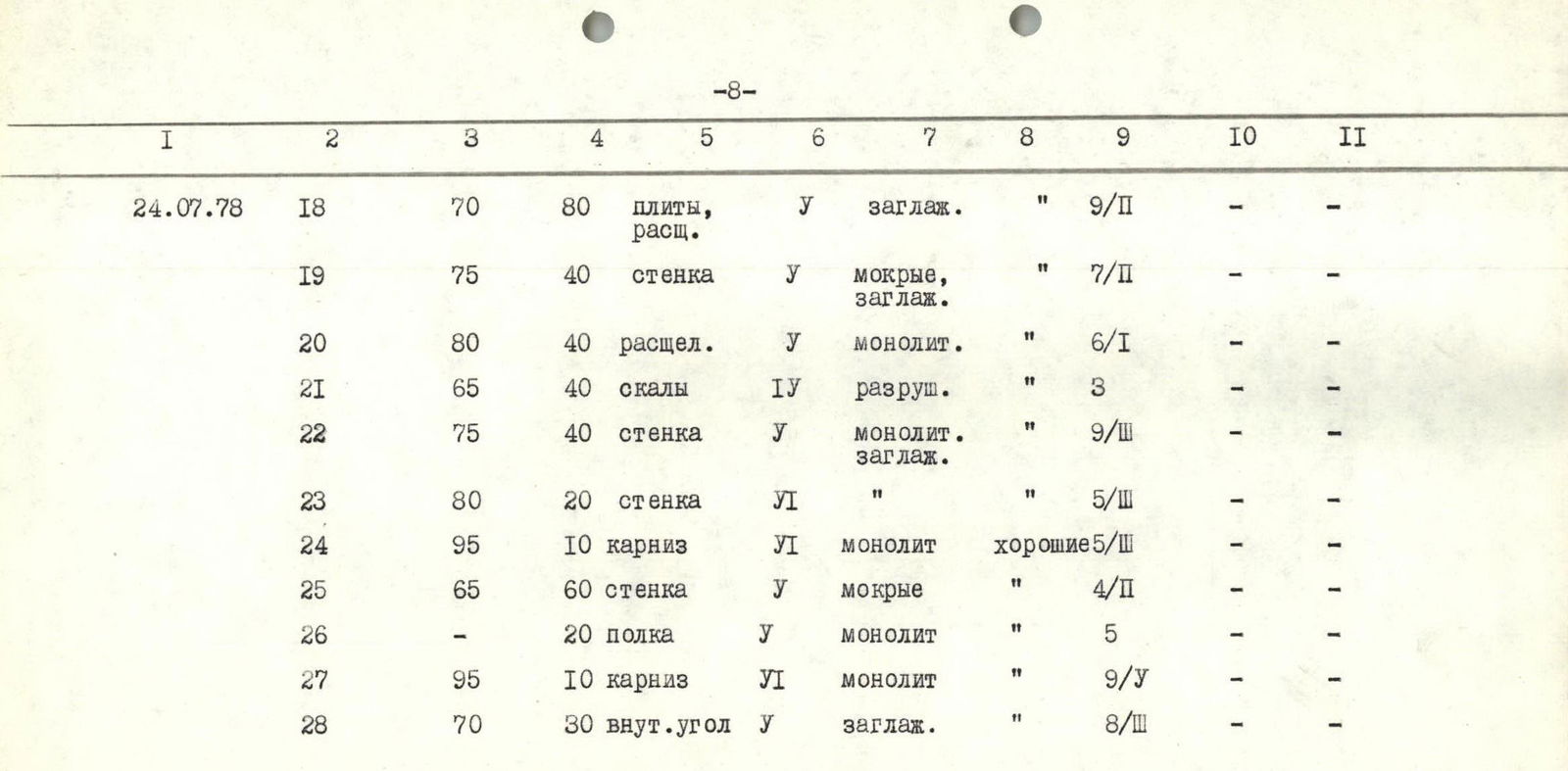
| July 25, 1978 | R29 | 80° | 20 m | rock tower | 7/II | monolith | cold | |||
|---|---|---|---|---|---|---|---|---|---|---|
| R30 | 55° | 120 m | rocks | 6 | snow-var. | « | ||||
| R31 | 75° | 30 m | rock tower | 10/III | iced | « | ||||
| R32 | 85° | 120 m | wall | 18/II | monolith | good |
July 25, 1978. Departure from the bivouac on the ascent at 9:00, stop at 20:00.
- Number of climbing hours — 11 hours
- Bivouac sitting
- On an ice platform
| July 26, 1978 | R33 | 15° | 60 m | shelf | 6 | iced | cold | 2 | ||
|---|---|---|---|---|---|---|---|---|---|---|
| R34 | 60° | 150 m | rocks | 5 | snow-covered | good | ||||
| R35 | 50° | 20 m | ice wall | « | « | 2 | ||||
| R36 | 1500 m | rocks | destroyed | « |
July 26, 1978. Departure from the bivouac on the ice shelf at 7:30, arrival at the summit — 17:30. Number of climbing hours — 105.
Brief explanation of the table
July 22, 1978. The first to work was the Abramov — Lunyakov rope team.
R1 section. Along a snow-ice slope, we approach the scree under the wall and along it to the rocks. Simultaneous belaying.
R2 section. Medium-difficulty rocks. Alternate belaying.
R3 section. Wall. First, 20 m (75°) straight up, then traverse left along a fissure — 20 m, exit to a shelf for two. Difficult climbing. Pulling up backpacks.
R4 section. Wall with a cornice. Start of movement with boosting the first climber and then on ladders (4 m). Exit to a large scree shelf. Difficult climbing. Pulling up backpacks.
R5 section. Wall. Movement along a fissure left and up, wedging fingers, under an overhang. The cornice is bypassed on the left on ladders. Difficult climbing.
R6 section. Medium-difficulty rocks. Exit to a cornice. Alternate belaying.
R7 section. The cornice is bypassed left along a 5 m shelf. Then a vertical 15 m wall with good holds. Up and to the right (10 m). Exit under the wall.
R8 section. Wall — difficult climbing. Few holds. Then traverse left 3 m and further 4 m along a sheer wall with good holds.
R9 section. Movement along medium-difficulty rocks left and up to a wide scree shelf under the gray wall. Alternate belaying through ledges and pitons.
R10 section. Movement along a shelf under the monolithic edge. Bivouac.
July 23, 1978. The first to work was the Knyazev — Pryannikov rope team.
R11 section. Medium-difficulty rocks. Pitoon belaying.
R12 section. Movement along the monolithic edge. Smooth slabs like "layer cake." Difficult climbing.
R13 section. Wall. Climbed using ladders.
R14 section. We cross from the edge of the ridge to the right across a stream (40 m). Movement along medium-difficulty rocks, shelves (40 m).
R15 section. Destroyed rocks of medium difficulty. Alternate belaying, pitoon.
R16 section. Wall — "live" stones. Difficult climbing.
R17 section. Left and up along steep snow-covered rocks — exit under the steep ascent of the edge. Bivouac.
July 24, 1978. The first to work was the Lunyakov — Abramov rope team.
R18 section. Smooth slabs. Movement: * first along a fissure right and up, * then along slabs on friction.
R19 section. Wall. Wet smooth rocks. Difficult climbing. Pulling up backpacks. Then traverse left and up along a 5 m shelf.
R20 section. Wall. Movement along a fissure left and up along monolithic rocks. Exit under destroyed rocks. Difficult climbing. Pulling up backpacks.
R21 section. Rocks. Climbed straight up.
R22 section. Wall. * Smooth, very difficult rocks with few holds. * Then traverse right and up 20 m. * Use of ITO. * Pulling up backpacks.
R23 section. Wall. Very difficult climbing. Movement on ladders. Pulling up backpacks.
R24 section. Cornice. Movement on ladders straight up.
R25 section. Wall. First, a 30 m wall (65°), then a sheer 7 m wall. Exit to a shelf for two. Further along snow-covered wet rocks (60°) — 20 m, exit to a shelf.
R26 section. Traverse left along a shelf (20 m) under the cornice. Very difficult climbing.
R27 section. Cornice. Climbed straight up using ITO. Exit to a shelf under a snow cornice, which is bypassed on the left.
R28 section. Movement on ladders along an internal corner right and up (10 m). Smooth rocks, then along slabs also right and up (10 m). Bypass of an overhanging section on the right (10 m), further along gentle slabs, we exit to a snow-rock section of the edge. Very difficult climbing. Bivouac.
July 25, 1978. The first to work was the Abramov — Lunyakov rope team.
R29 section. Along simple rocks, we approach under the rock tower on the edge (20 m). Further movement along the tower right and up. Very difficult climbing. ITO used.
R30 section. Movement along destroyed rocks (40 m) and further along snow (80 m) to a rock tower under the rusty wall. Alternate belaying.
R31 section. The tower is bypassed on the right: * First along a shelf covered in ice (5 m); * Then along a wall (80°) — 3 m, ice accretion; * On the right — a vertical chimney (2 m) filled with snow, leading to a shelf for two. Further along an iced wall — exit under the rusty wall. Platform for four. Very difficult climbing.
R32 section. Wall. From the platform, first 15 m right and up along a wall with breaking holds. Then traverse right along a smooth slab (5 m) and further 15 m up to a small shelf for one. Then traverse left to a ledge (8 m) and along the ledge 30 m (90°), wedging hands and feet into it. Exit to a platform for one. Quick pulling up of backpacks. Then 35 m along steep slabs (85°) — exit to a snow-ice shelf. Very difficult climbing. Bivouac.
July 26, 1978. The first to work was the Knyazev — Pryannikov rope team.
R33 section. Movement along a snow-ice shelf. Step-cutting.
R34 section. Ascent to the ridge along destroyed snow-covered rocks. Alternate belaying, pitoon.
R35 section. Ice wall. Step-cutting. Exit to the pre-summit ridge.
R36 section. The ridge is bypassed on the right along destroyed rocks with large scree shelves. Exit to the summit.
Conclusions and recommendations
- The route is logical and objectively safe, mainly rock.
- Compared to previously climbed routes (Engels peak South ridge, Lithuania on the 4th bastion of the Southwest wall, Moscow Pravda (South) peak via the East wall, Simagin on the North counterfort), this route, resembling them in terms of relief structure in certain sections, is ultimately longer and more complex.
We believe that the route deserves a classification of 5B category difficulty.
- We recommend starting the ascent before 9:00, as rockfall occurs on the left and right later.
- Most sections, except for iced, ice, and snow sections, are climbed in galoshes. We recommend bringing galoshes for all participants on the ascent.

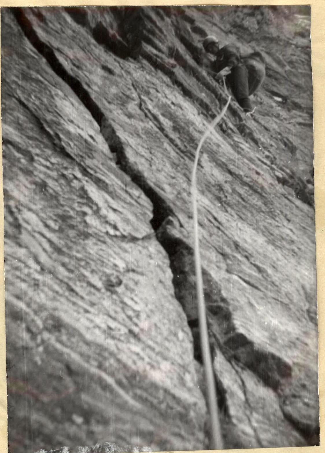
Photo 2 (angle 22)
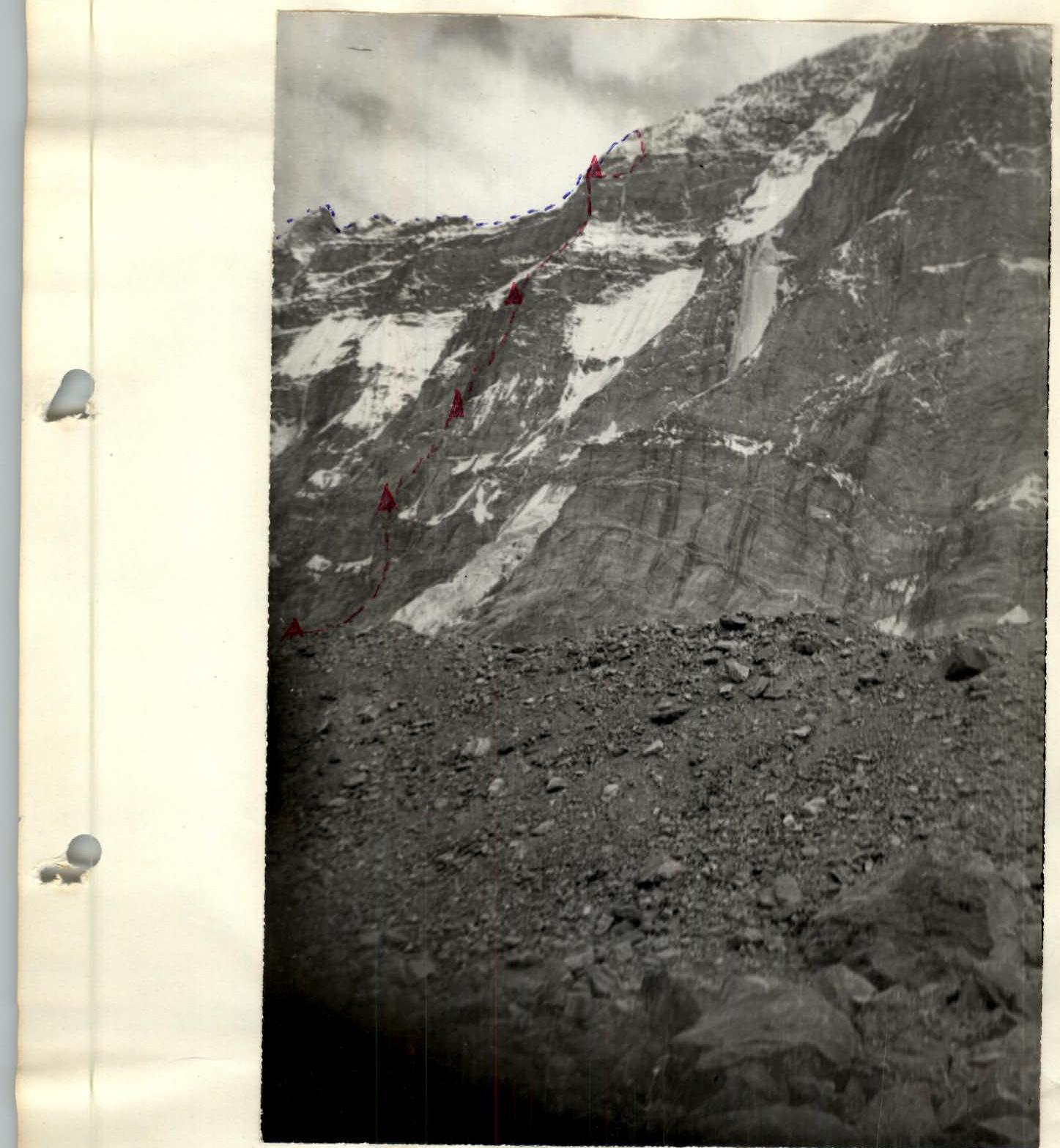
Photo 1 (profile)

Graph of steepness of ascent to Moscow Pravda peak via the right Northeast edge 5B category difficulty. Average steepness 63°, height difference 1200 m.
χRXXV–50°20 m χRXXXIV–60°150 m
