FOR THE CHAMPIONSHIP OF THE CENTRAL COUNCIL OF THE ZENIT VOLUNTARY SPORTS SOCIETY
in the II category of high-altitude and technical ascents.
P. MOSKOVSKAYA PR AVDA VIA THE EASTERN RIDGE 45 cat. tr.
TEAM MOSCOW ZENIT VOLUNTARY SPORTS SOCIETY:
- SHATILOV V.N. — TEAM LEADER
- KRUTYKH A.V.
- KRAYUSHKIN D.A.
- SAFRONOV V.A.
August 5–7, 1972
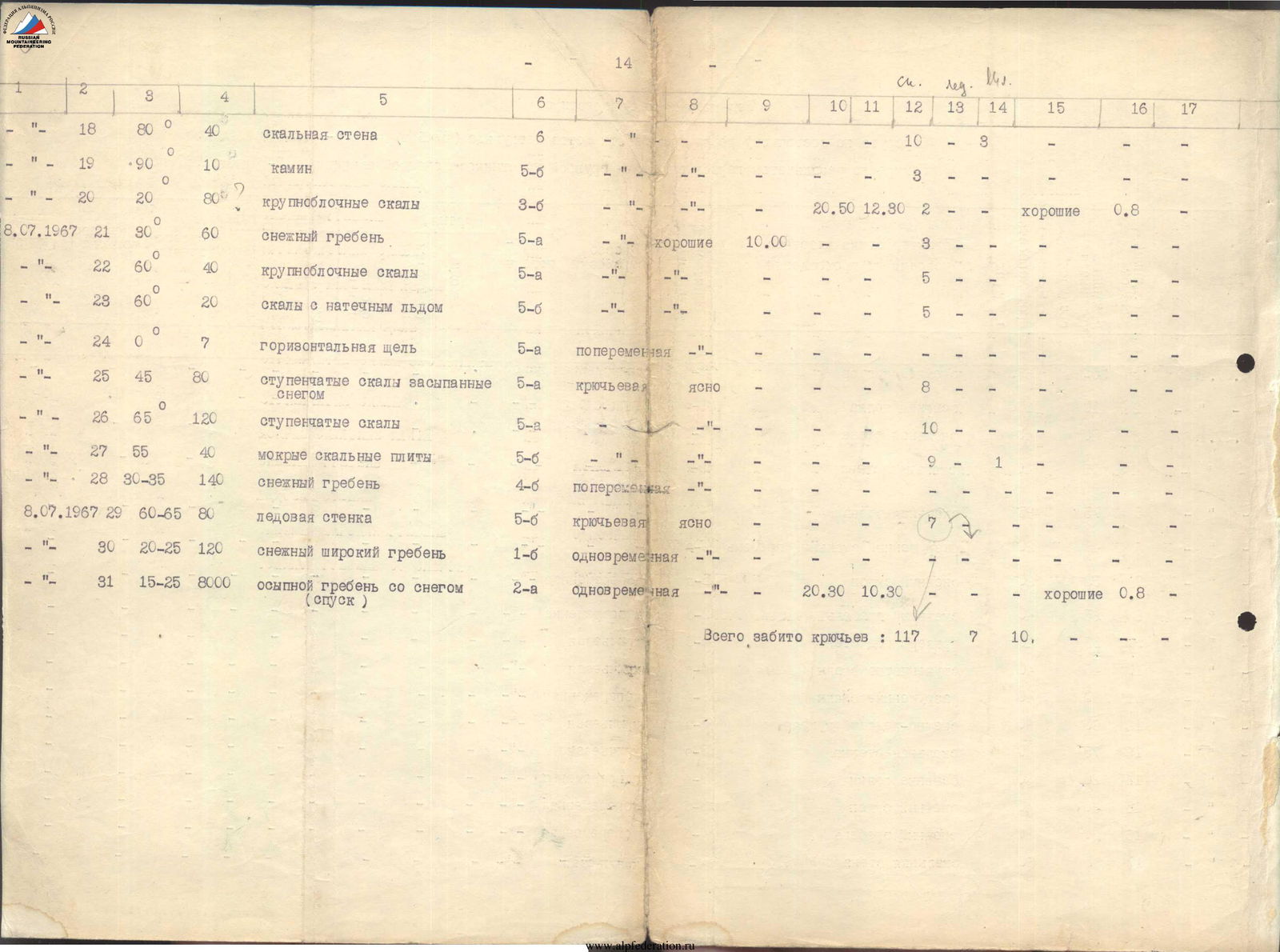
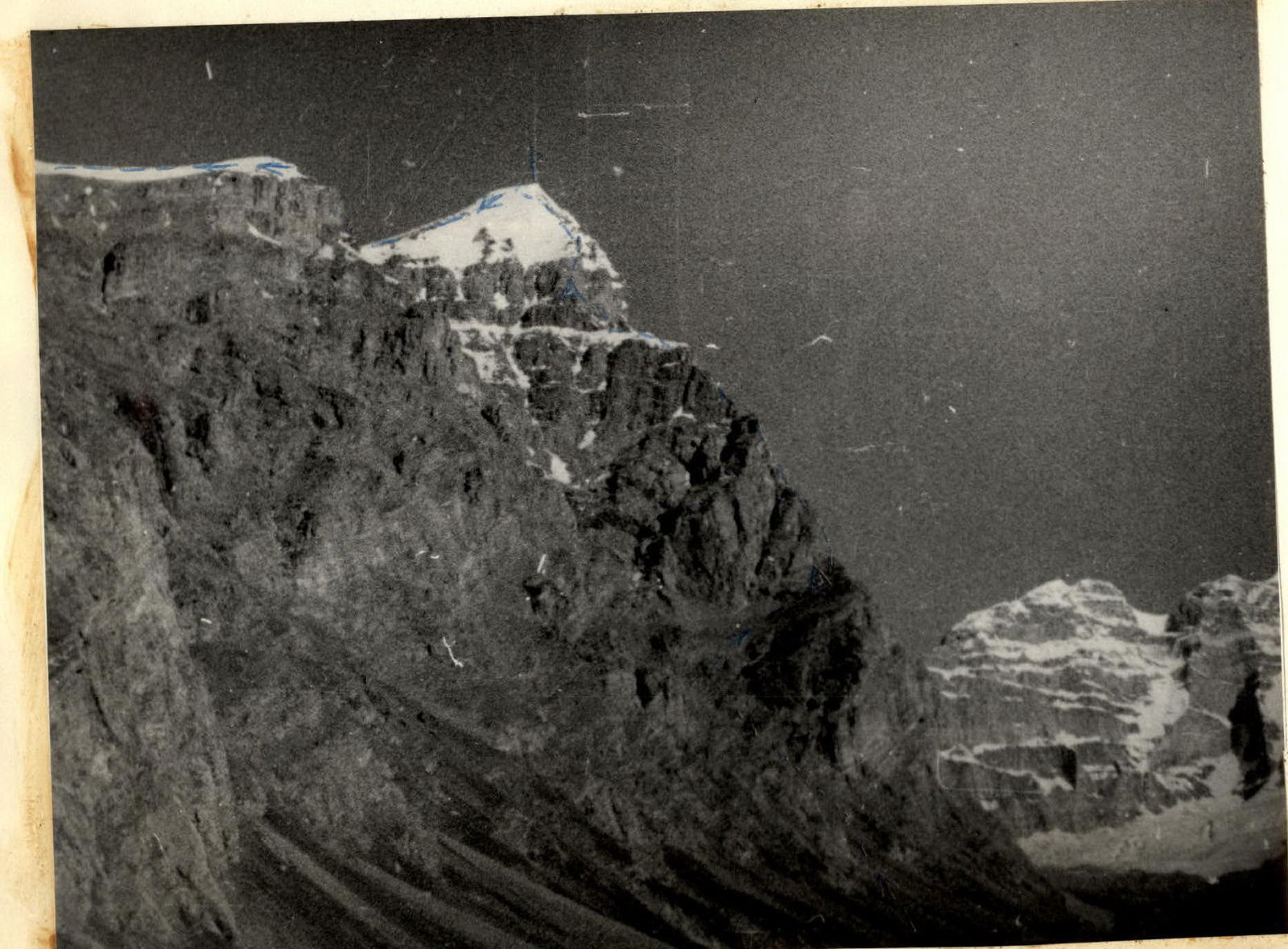
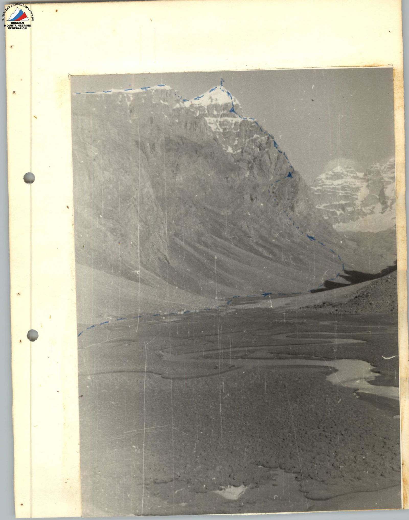
Technical characteristics of the route along the eastern ridge of Pik Pamyati Zhertv Tetnuldа (5746 m) in the southwestern Pamir, based on the results of the first ascent by a group of participants in the Donetsk Alpinade on July 6–8, 1967.
| Date | Section traversed | Average slope in degrees | Length in meters | Characteristics of sections and conditions of passage | Technical difficulty | Type of belay | Weather conditions | Time of departure | overnight stops | working hours | Rock pitons driven | Ice pitons | Bolt pitons | Overnight conditions | Daily ration weight | Notes |
|---|---|---|---|---|---|---|---|---|---|---|---|---|---|---|---|---|
| 1 | 2 | 3 | 4 | 5 | 6 | 7 | 8 | 9 | 10 | 11 | 12 | 13 | 14 | 15 | 16 | 17 |
| July 6, 1967 | R1 | 30–35° | 350 m | Snow couloir | 3 | Alternating | Clear | 6:00 | – | – | – | – | – | – | – | – |
| – " – | R2 | 10° | 150 m | Scree shelf | 1 | Simultaneous | – " – | – | 10:00 | 4 ч | – | – | – | Good | 7 | 10 |
| July 7, 1967 | R3 | 80° | 40 m | Rock wall | 5 | Piton belay | – " – | 8:20 | – | – | 10 | 1 | – | – | Обра | – |
| – " – | R4 | 75° | 40 m | Rock wall | 5 | – | – | – | – | – | 11 | 1 | – | – | ботано 6 июля 1967 г. | |
| – " – | R5 | 75° | 35 m | Rock wall | 6 | – | – | – | – | – | 18 | 2 | – | – | – | – |
| – " – | R6 | 45° | 20 m | Destroyed rocky ridge | 4 | – | – | – | – | – | 1 | – | – | – | – | – |
| – " – | R7 | 50° | 20 m | Snow slope | 5 | Alternating | – " – | – | – | – | – | – | – | – | – | – |
| – " – | R8 | 25° | 40 m | Rocky ridge | 2 | Simultaneous | – " – | – | – | – | – | – | – | – | – | – |
| – " – | R9 | 15° | 40 m | Traverse under the wall | 5 | Piton belay | – " – | – | – | – | 4 | 2 | – | – | – | – |
| – " – | R10 | 45° | 40 m | Stepped rocks | 4 | Piton belay | – " – | – | – | – | 2 | – | – | – | – | – |
| – " – | R11 | 30° | 40 m | Destroyed rocks | 3 | Alternating | – " – | – | – | – | – | – | – | – | – | – |
| – " – | R12 | 60° | 30 m | Snow-ice couloir | 5 | Piton belay | – " – | – | – | – | 6 | – | – | – | – | – |
| – " – | R13 | 75° | 40 m | Rocky wall | 5 | Piton belay | – " – | – | – | – | 6 | – | – | – | – | – |
| – " – | R14 | 20° | 80 m | Scree shelves | 3 | Simultaneous | – " – | – | – | – | – | – | – | – | – | – |
| – " – | R15 | 30° | 40 m | Snow slope | 3 | Alternating | – " – | – | – | – | – | – | – | – | – | – |
| – " – | R16 | 200° | 80 m | Snow ridge | 4 | Alternating | – " – | – | – | – | – | – | – | – | – | – |
| – " – | R17 | 60° | 60 m | Rocky wall | 4 | Piton belay | – " – | – | – | – | 4 | – | – | – | – | – |

Brief Geographical and Geological Characteristics
P. Marx Region.
The region of Pik Marx and Pik Engels is located within the Gorno-Badakhshan Autonomous Region of the Tajik SSR, in the southwestern Pamir, within the geographical coordinates: 37°02′ – 37°36′ north latitude and 72°29′ – 72°32′ east longitude. Climbers began to explore this area relatively recently compared to other regions of the Pamir and Tian Shan.
With modern transportation development, reaching this area might seem not very complicated. However, due to the capricious weather in the western spurs of the Pamir and the existence of the so-called Rushan "window" (a narrow gorge under the Rushan River), flights from Dushanbe to Khorog are often delayed for an indefinite time. Therefore, getting from Dushanbe to Khorog by an ordinary truck is often much faster.
The Kishty-Dzherob valley stretches submeridionally for 20 km from northwest to southeast. The western slope of the valley is steep and cliffy for most of its length, while the eastern slope is gentler and scree-covered. The valley is blocked by the massif of Pik Engels and Pik 40-letiya Komsomola Ukrainy.
Geologically, the bottom of the Kishty-Dzherob valley and its slopes up to an altitude of 4600–5400 m are composed of ancient Precambrian rocks such as dark gray gneisses with various shades, which are hard and dense.
The upper parts of the ridges are composed of:
- Magmatogenic rocks of granitoid composition (western slope of the valley);
- Light gray, sometimes white, metamorphogenic marbles (eastern slope of the valley and the massif of Pik Engels, Pik 40-letiya Komsomola Ukrainy).
The metamorphic rocks of the upper belt are softer and more susceptible to weathering.
Throughout the upper part of the Kishty-Dzherob valley, a clear contact line is visible between the lower series of Precambrian gneisses and the upper series of magmatogenic and metamorphic rocks.
On the massif of Pik Engels — Pik 40-letiya Komsomola Ukrainy and on the Lietuva massif (eastern slope of the valley), in addition, layers of white marbles with a thickness of up to 30–40 m are clearly traceable in the upper part.
The Kishty-Dzherob glacier is relatively small (about 8 km long) and even, with a minor ice fall only when ascending to the Nispir Pass, in the northeastern part of the glacier. The glacier is closed, with the thickness of the upper, "loose" part of the snow cover being 15–20 cm. Kahlgaspur is almost not observed, and seracs are rare.
The Zugvand glacier looks similar in its upper part.
Day 1 — August 5.
At 17:00, the group left the base camp for the ascent. The weather is good. They ascended via a snow couloir to a wide inclined shelf. This is where the night's stay and the start of the route are. Under the overhanging wall, they set up a tent. They inspected and processed the start of the route — 2 ropes. They prepared dinner and immediately packed breakfast.
They checked their equipment and established radio communication with the base camp and other groups. At 22:00, they went to sleep.
Day 2 — August 6.
The morning is cloudy. They started the route at 7:00. They passed a wall, then a steep inclined snow shelf. It started raining with snow. Visibility worsened, and the rocks quickly became wet. Exercising caution, they decided to continue moving. They maintained radio contact with the camp at the scheduled hours. The route included many interesting rock and combined sections:
- There are plenty of places to organize belays
- Pitons drive well
They reached R1, left a note, and continued. The snowfall did not stop. Due to the bad weather, dusk arrived faster. At 19:00, they decided to spend the night on a small safe shelf, just two ropes away from the snow-ice ascent leading to the summit dome. Hoping the weather would improve, they went to sleep at 22:00.
Day 3 — August 7.
They woke up early, but unfortunately, the weather did not improve. The tent was covered in snow, and everything around was white. At 7:00, they were on the route. After passing 2 ropes of difficult rock, they reached a steep snowfield, starting a steep snow " takeoff" leading to the summit dome. They put on crampons. The slope in the upper part of the "takeoff" reaches 60–65°. They broke through the snow cornice and reached the summit plateau. At 10:00, they were on the summit. They replaced the note. At 10:30, they began their descent via the 2-pitch route.

Technical Characteristics
of the route along the eastern ridge of Pik D. Moskovskaya on the Pamir, based on the results
| Date | Section traversed | Average slope in degrees | Length in meters | Characteristics of sections and conditions of passage | Technical difficulty |
|---|---|---|---|---|---|
| 1 | 2 | 3 | 4 | 5 | 6 |
| August 5, 1972 | R1 | 30–35° | 350 m | Snow couloir | 3 |
| – " – | R2 | 10° | 150 m | Scree shelf | 1 |
| August 6, 1972 | R3 | 80° | 120 m | Rock wall | 5 |
| – " – | R4 | 40° | 20 m | Destroyed rocky ridge | 4 |
| – " – | R5 | 55° | 15 m | Snow slope | 4 |
| – " – | R6 | 25° | 40 m | Rocky ridge | 2 |
| – " – | R7 | 20° | 45 m | Traverse under the wall | 5 |
| – " – | R8 | 40° | 40 m | Stepped rocks | 4 |
| – " – | R9 | 25° | 35 m | Destroyed rocks | 3 |
| – " – | R10 | 65° | 30 m | Snow-ice couloir | 5 |
| – " – | R11 | 80° | 35 m | Rock wall | 4 |
| – " – | R12 | 25° | 70 m | Scree shelves | 2 |
| – " – | R13 | 35° | 40 m | Snow slope | 3 |
| – " – | R14 | 15° | 100 m | Snow ridge | 4 |
| – " – | R15 | 55° | 60 m | Rock wall | 4 |
| – " – | R16 | 80° | 40 m | Rock wall | 5 |
| – " – | R17 | 90° | 15 m | Chimney | 5 |
| – " – | R18 | 25° | 70 m | Large-block rocks | 3 |
| – " – | R19 | 30° | 60 m | Snow ridge | 5 |
| – " – | R20 | 60° | 45 m | Large-block rocks | 4 |
| August 7, 1972 | R21 | 60° | 20 m | Rocks with ice accretion | 5 |
| – " – | R22 | 5° | 10 m | Horizontal crevice | 4 |
| – " – | R23 | 40° | 70 m | Stepped rocks covered in snow | 4 |
| – " – | R24 | 55° | 45 m | Wet rock slabs | 5 |
| – " – | R25 | 30–35° | 130 m | Snow ridge | 4 |
| – " – | R26 | 55–60° | 80 m | Snow-ice wall | 5 |
| – " – | R27 | 20° | 130 m | Wide snow ridge | 1 |
| – " – | R28 | 20° | 5000 m | Scree ridge (descent) | 2 |
True (5746 m) in the southwestern Pamir, based on the results of the ascent by the MOS ZENIT VOLUNTARY SPORTS SOCIETY team on August 5–7, 1972.
| Type of belay | Weather conditions | Time of departure | overnight stops | working hours | Rock pitons driven | Ice pitons | Bolt pitons | Overnight conditions | Daily ration weight | Notes |
|---|---|---|---|---|---|---|---|---|---|---|
| 7 | 8 | 9 | 10 | 11 | 12 | 13 | 14 | 15 | 16 | 17 |
| Alternating | Clear | 14:00 | – | – | – | – | – | – | – | – |
| Simultaneous | – " – | 16:00 | 4 ч | – | Good | 3,5 | – | – | – | – |
| Piton belay | Cloudy | 7:00 | – | 20 | – | – | – | – | – | – |
| – " – | – " – | – | – | 3 | – | – | – | – | – | – |
| Alternating | – " – | – | – | – | – | – | – | – | – | – |
| Simultaneous | – " – | – | – | 7 | – | – | – | – | – | – |
| Piton belay | – " – | – | – | 2 | – | – | – | – | – | – |
| – " – | – " – | – | – | 3 | – | – | – | – | – | – |
| Alternating | – " – | – | – | – | – | – | – | – | – | – |
| Piton belay | – " – | – | – | 4 | – | – | – | – | – | – |
| – " – | – " – | – | – | – | – | – | – | – | – | – |
| Simultaneous | – " – | – | – | – | – | – | – | – | – | – |
| Alternating | – " – | – | – | – | – | – | – | – | – | – |
| – " – | – " – | – | – | – | – | – | – | – | – | – |
| Piton belay | – " – | – | – | 8 | – | – | – | – | – | – |
| – " – | – " – | – | – | 9 | – | – | – | – | – | – |
| – " – | – " – | – | – | 2 | – | – | – | – | – | – |
| – " – | – " – | – | – | 2 | – | – | – | – | – | – |
| Piton belay | Cloudy | – | – | 2 | – | – | – | – | – | – |
| – " – | – " – | – | 19:00 | 12 ч | 2 | – | – | Good | 2,0 | – |
| Piton belay | Cloudy | 7:40 | – | – | 2 | – | – | – | – | – |
| Alternating | – " – | – | – | – | – | – | – | – | – | – |
| Piton belay | – " – | – | – | 4 | – | – | – | – | – | – |
| – " – | – " – | – | – | 4 | – | – | – | – | – | – |
| Alternating | – " – | – | – | – | – | – | – | – | – | – |
| Piton belay | – " – | – | – | 2 | 3 | – | – | – | – | – |
| Simultaneous | – " – | – | – | – | – | – | – | – | – | – |
| – " – | – " – | – | 14:00 | 6 ч 20 мин | – | – | – | Base camp | – | – |
Total pitons driven: 74.