
REPORT
ON THE FIRST ASCENT OF PEAK 5112 M (MEYDAN) VIA THE WESTERN RIDGE FROM THE PASS BETWEEN PEAKS 5112 M AND 5378 M (SOUTHWEST PAMIR, SHAKHDARINSKY RANGE, VAKHAN RANGE, VNUKUT VALLEY)
Group members: GUDYALIS A.V., SIMUTIS R.YU.
Organization: Committee for Physical Culture and Sports under the Council of Ministers of the Lithuanian SSR
Address: Zemaite's 6
Phone: 63-53-53
Team leader and coach: GUDYALIS Algis Vitautovich 233021, Lithuanian SSR, Kaunas, Kanyuku 1st, 4, apt. 17, work phone 26-45-91, home phone 22-53-41, 75-35-11.
All heights mentioned in the report are determined using a topographic map. www.alpfederation.ru↗
 www.alpfederation.ru↗
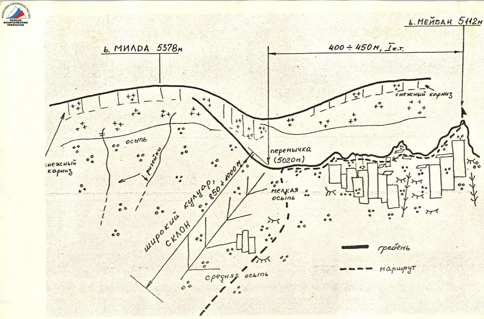
Route description to peak 5112 m (Meydan) via the western ridge from the pass between peaks 5112 m and 5378 m, category 1B difficulty
From the base camp at the confluence of the Vnukut and Chondzhirav rivers (3520 m), cross the Vnukut River and ascend westwards up the valley to the pass between peaks 5112 m and 5378 m. This valley is located opposite the Chondzhirav River. A small stream flows through the valley, sometimes disappearing under rocks. After 1 hour of ascent, there is a waterfall. The ascent should be made along the right slope of the valley. The slope is steep in places, with rock outcrops. Rockfall hazard!
Ascent:
- After 3 hours, reach the pass (5020 m) via scree slopes.
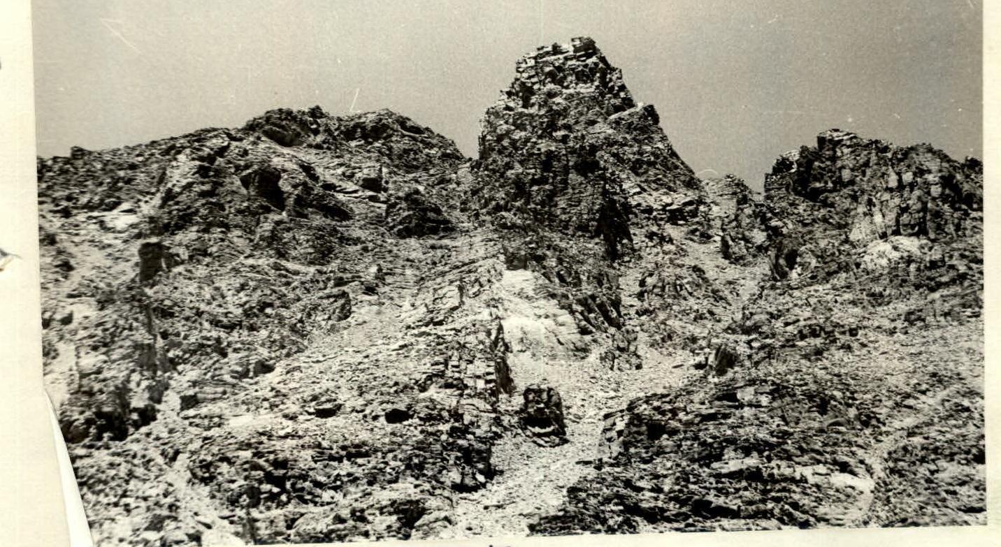
- From the pass, ascend to peak 5112 m via broken rocks, ledges, and scree slopes, taking about 40 minutes.
Features:
- A small hanging glacier descends from the peak to the northeast.
- A control tower is located at the summit.
Total ascent time from the base to the summit is 3.5–4 hours.
The descent along the ascent route from the summit to the base camp takes about 2 hours.
The descent is hazardous due to rockfall!
Crossing the Vnukut River in the afternoon is hazardous!
The entire route from the base camp to the base camp takes about 5–6 hours.
Recommended for acclimatization and area exploration.
Brief historical and geographical overview of the area
Peaks 5350 m (Vrang), 5998 m (Darius and Girėnas), 6004 m (Lituanica), 5879 m (KPI), 5649 m (Academician Baršauskas) are located in the Southwest Pamir, in the eastern part of the Shakhdarinsky Range, specifically in the Vakhan Range.
The nearest explored areas by climbers are:
- the Marx Peak area (6726 m)
- the Engels Peak area (6510 m) - to the east
- the 6138 m peak area (Armed Forces)
- the 6038 m peak area (Baikonur) - to the west.
During his 1904 journey across the Pamir, B.A. Fedchenko explored and described the Shakhdarinsky Range area, located between the Shakhdara and Pyanj rivers.
Climbing exploration of the Shakhdarinsky Range began in 1946 with the conquest of Karl Marx Peak. In subsequent years, several expeditions were organized, mainly in the areas of Marx and Engels peaks.
The central part of the Shakhdarinsky Range was first explored in 1974 when the walls later named Luknitsky Peak were accidentally discovered by V.P. Nekrasov. In 1975, an expedition by the Armed Forces led by Nekrasov V.P., based at Lake Zardiv, conquered the 5800 m peak via a category 5B route on the NW edge. This peak was named Luknitsky.
In subsequent years, army climbers and other alpine expeditions completed several interesting routes of categories 5B and 6B in this area, becoming prize-winners of the USSR Alpine Championship.
However, the part of the Shakhdarinsky Range between the Dzhentivon and Marx peaks remained unknown to climbers until 1983 and was only visited by a few groups of tourists.
The reason for such late exploration of the area is likely due to:
- The peaks not being visible from settlements near the road
- The areas of Engels, Marx, Luknitsky, and Mayakovsky peaks being more popular among climbers.
Preliminary reconnaissance of the Vakhan Range area (Yančung, Saryyang, Vnukut, and Chondzhirav valleys) was conducted in 1983 by a reconnaissance group from the Lithuanian SSR Sports Committee (Gudyalis A.V. and Simutis R.Yu.). Photos of the Vakhan Range peaks were taken, and routes were visually studied.
For climbers, the most attractive peaks are those that have not been climbed before, especially if they reach or exceed 6000 m in height.
In the summer of 1984, an expedition from the Lithuanian SSR Sports Committee, led by Gudyalis A.V., arrived in the Vnukut valley to explore the area from an alpine perspective and conquer previously unclimbed peaks, assigning them corresponding names.
The expedition established its base camp at the confluence of the Vnukut and Chondzhirav rivers, at an altitude of 3520 m, approximately 3 hours' walk from the Vrang village.
From an alpine perspective, the area is very interesting for climbers from 2nd sports category to Candidate Master of Sports. There are many routes to the peaks, ranging from category 3A to 5B, including rock, combined, and snow-ice routes.
Approaches to the routes take 3–8 hours from the base camp. Many first ascents are possible.
Rivers are turbulent and difficult to cross in the afternoon. Weather is generally stable, although in August 1984, a sharp cold snap, thunderstorms, and rain were observed for a week, preventing many ascents.
The flora and fauna of the valley are not rich. Ephedra and Rhodiola rosea are rarely found.
In the upper reaches of the Vnukut and Chondzhirav rivers, there are pastures and summer shepherds' camps.
Overview of the ascent area
The nearest settlement is Vrang (between Ishkashim and Lyangar). The approach from Vrang to the confluence of the Vnukut and Chondzhirav rivers takes well-trained and acclimatized climbers with backpacks (25 kg) 2 hours and 40 minutes.
Peak 5112 m (MEYDAN) is located in a lateral spur of the Vakhan Range and is not clearly visible from the valley. It becomes visible during the approach (3 hours up the valley, about 2000–2500 m before the 5020 m pass) through a lateral spur.
From the 5020 m pass, it is possible to ascend peak 5378 m (Milda) via a category 2A route.
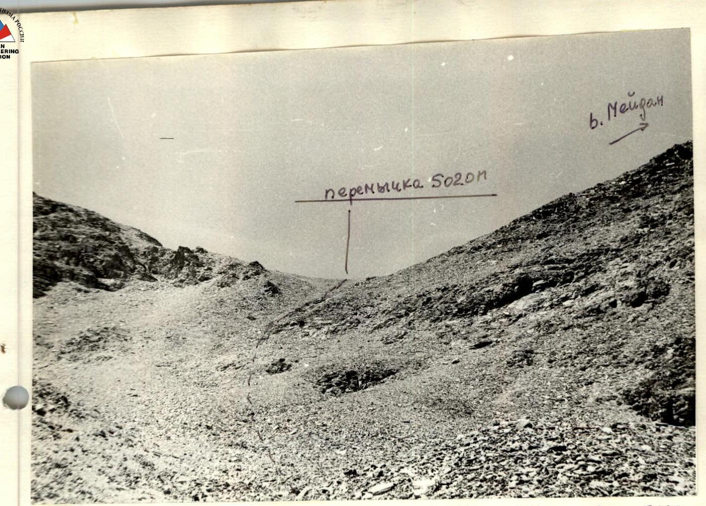 The 5020 m saddle between peaks 5378 m (Milda) and 5112 m (Meydan).
 Peak MEYDAN. View from peak Vitautas (5586 m) to the south.
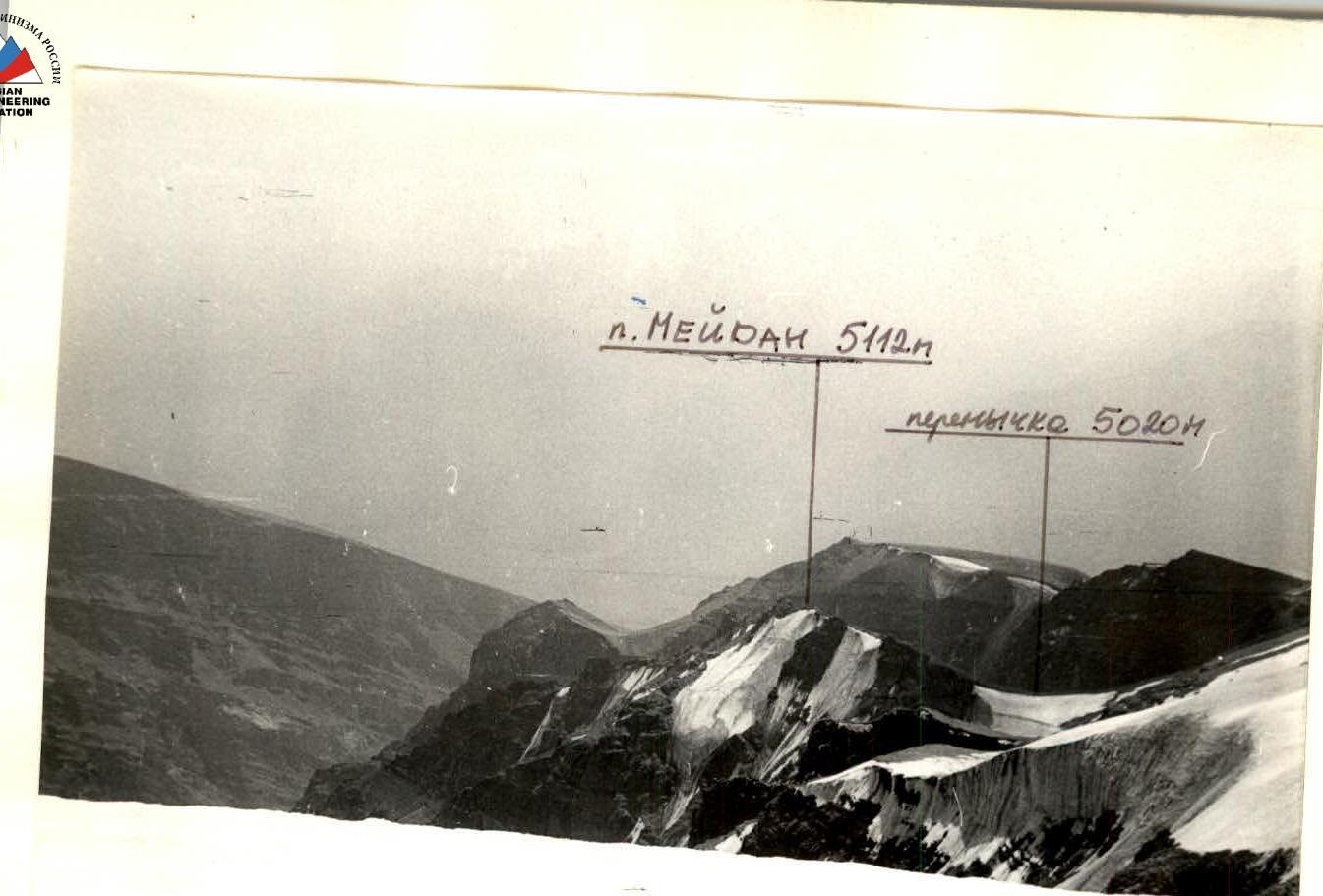 Peak MEYDAN. View from peak Vitautas (5586 m) to the south.
