To the Classification Committee of the USSR Alpine Federation Moscow
REPORT
ON THE FIRST ASCENT OF MARX PEAK (6726) VIA THE NORTH-WEST RIDGE ON THE SOUTH-WESTERN PAMIR, MADE BY THE COMBINED TEAM OF ALPINISTS FROM THE DNEPROPETROVSK REGIONAL COMMITTEE FOR PHYSICAL CULTURE AND SPORTS.
August 1–16, 1971
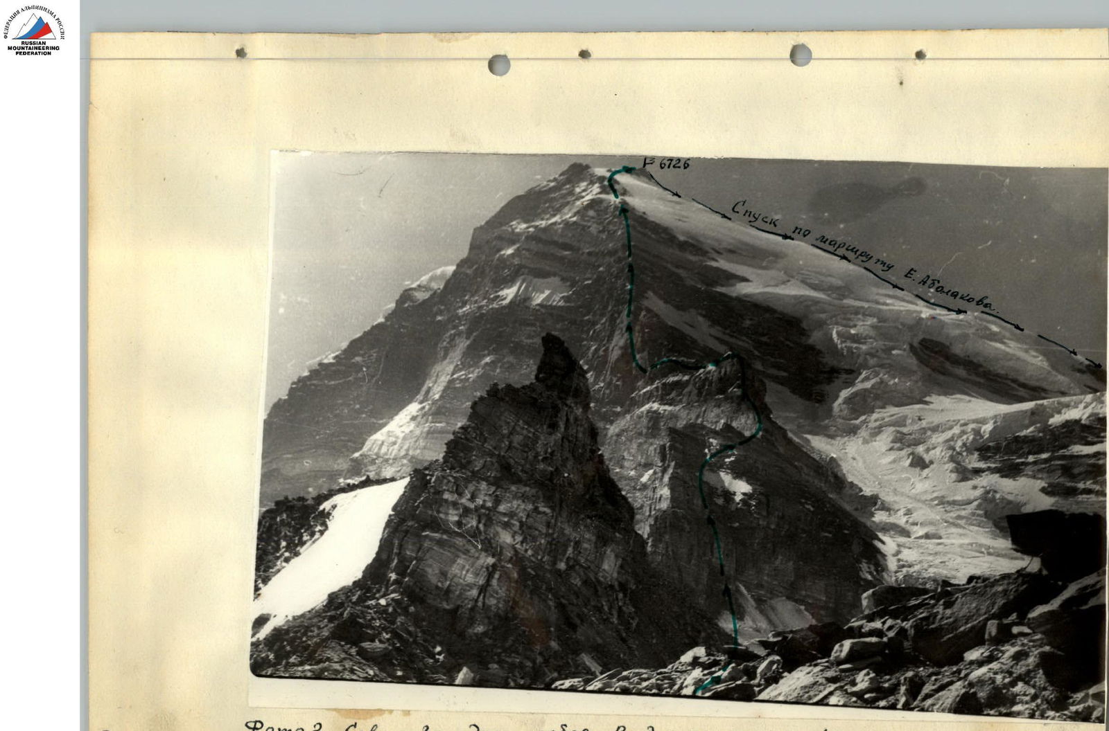 Photo 2. North-West ridge. View from the 4900 col
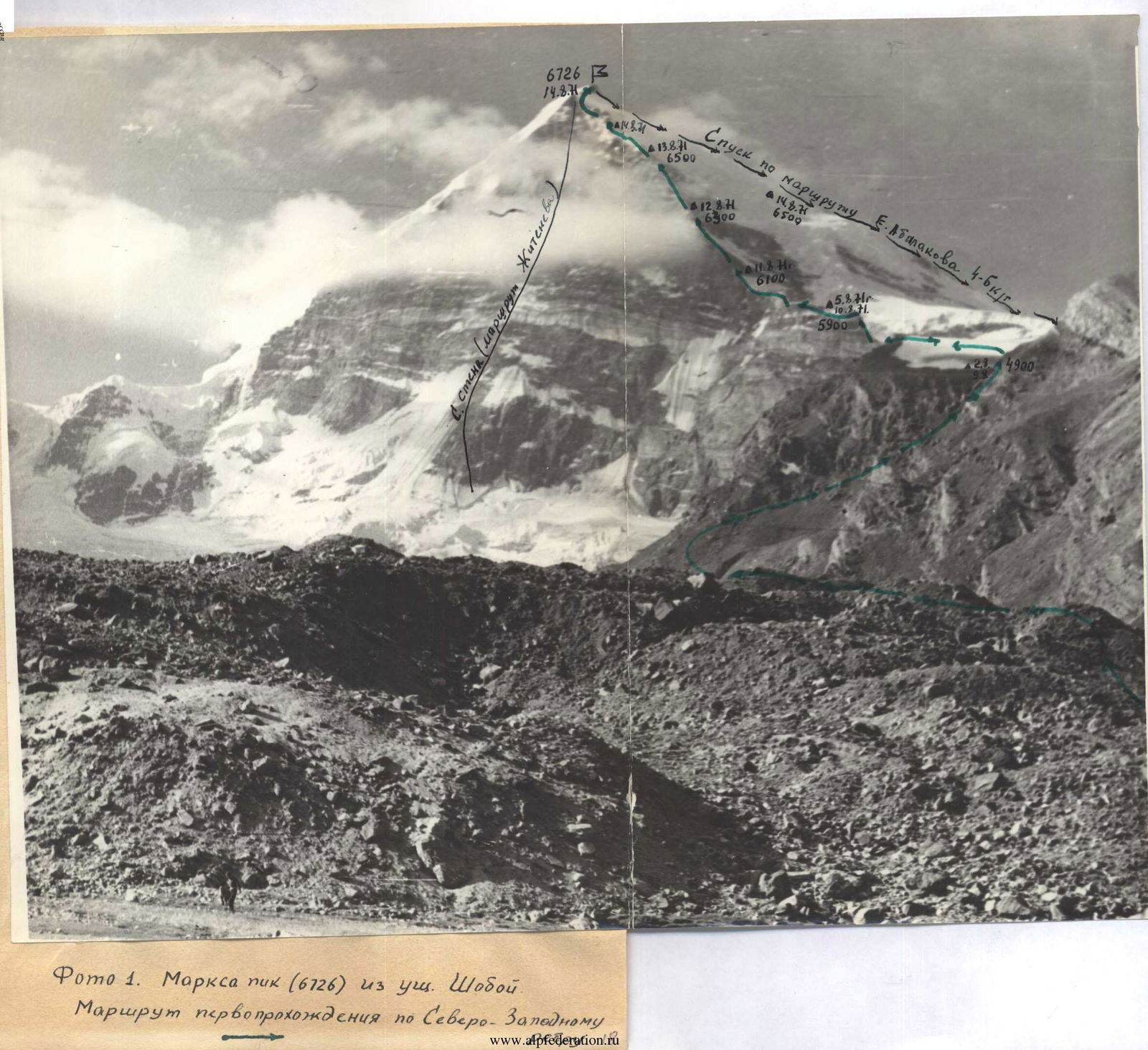 Photo 1. Marx Peak (6726) from Shoboy valley. Route of the first ascent via the North-West ridge
 Photo 3. Ascent route profile. Above 6000 m.
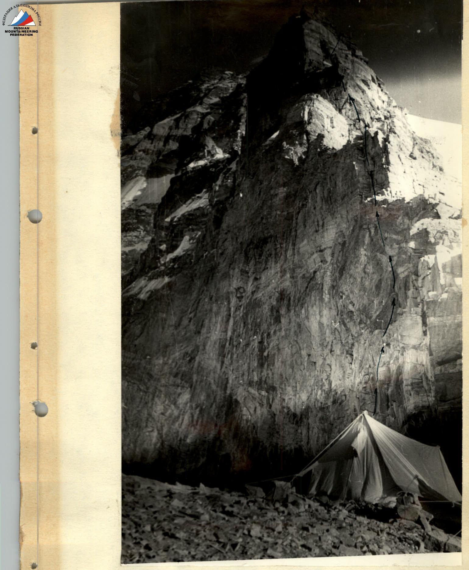 Photo 4. Bivouac before the III rock "gendarme". Section R5–R6
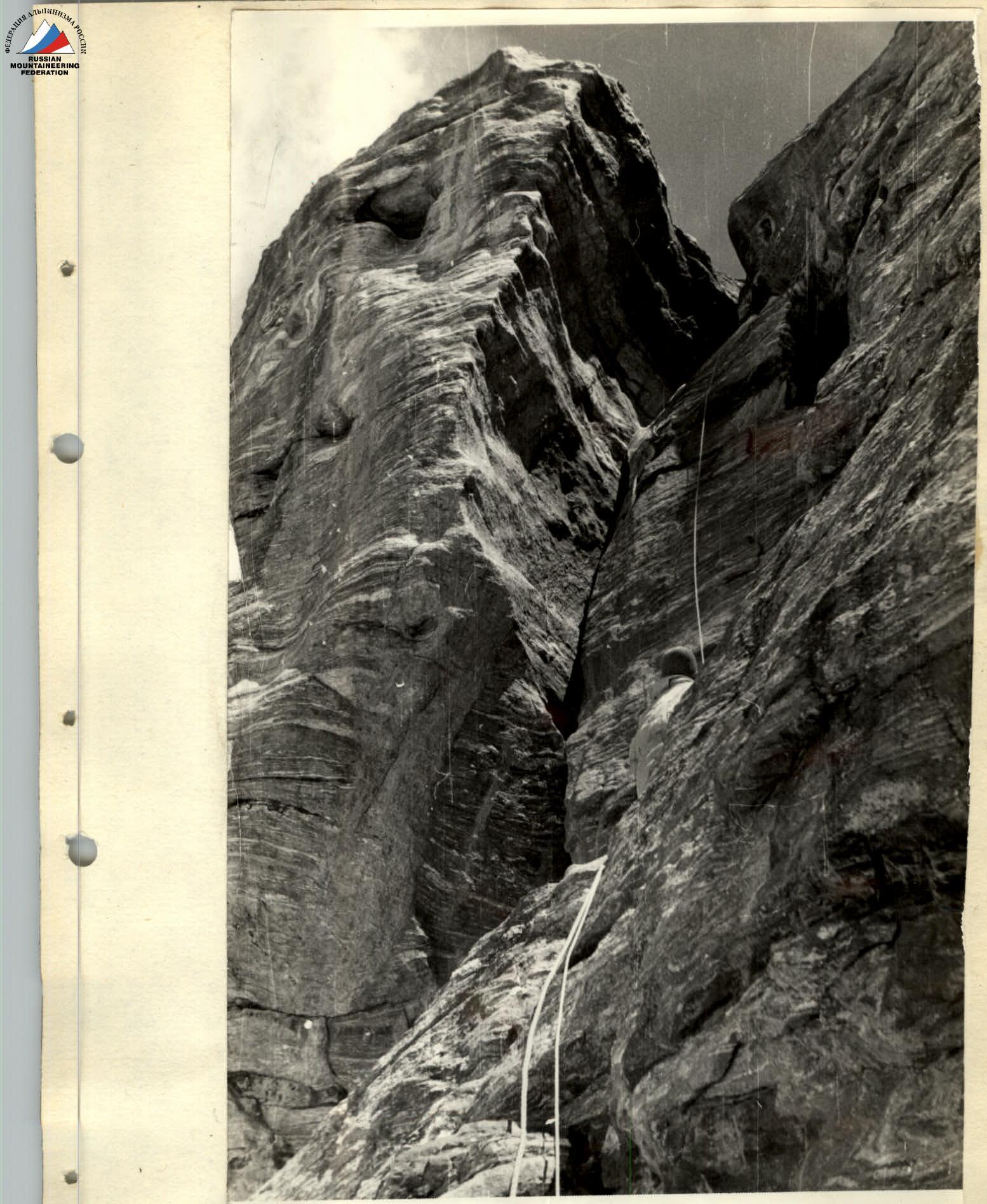 Photo 5. Character of the rocks of the IV rock "gendarme". Section R10–R11
Composition of the Assault Team
| 1. | PRUDNIKOV V.K. | CMS | — team leader |
| 2. | SAMOILENKO V.I. | CMS | — participant |
| 3. | YERSHOV YU.A. | CMS | — participant |
| 4. | GREBENKIN V.A. | 1st category | — participant |
All participants conducted year-round training on rock outcrops in the quarry (Taromskoe village, Zheltye Vody town).
A week-long gathering was held in May on the rocks of Krestovaya Mountain (near Yalta).
In addition, all members of the main group made joint ascents of 5th and 6th category of difficulty in the 1967–1970 seasons in the Caucasus, Pamir, and Tian Shan.
Thus, in 1970:
- Prudnikov and Samoilenko made an ascent of Peak Pobeda (7439 m) via a 6B category route.
- Yershov and Grebenkin ascended Zapadnaya Pobeda via a 5B category route.
The whole team made a training ascent to an unnamed peak with an altitude of 5800 m.
During acclimatization and reconnaissance outings, the participants felt well, and the initially selected composition of the main group remained unchanged.
The team was trained by the permanent coach, Master of Sports of the USSR, Senior Alpine Instructor A.M. Zaidler.
August 1. We leave the base camp at 7:00. We reach the "4900" col by 15:00. Overnight stay.
August 2. Departure at 7:00. We bypass the first "gendarme" along a gently sloping glacier crevassed with cracks. The second "gendarme" is bypassed via an icefall. We move early, while the "bridges" still hold and the sun has not risen (in this area, it appears at 10:00 am). We ascend a steep glacier, 45–50° (crampons + ice hooks), and reach a steep talus. After 1.5 hours on the talus, we are on the ridge between the II and III "gendarmes". We struggle to find a spot for the tent, especially lacking snow for water.
August 3. We depart at 8:00. Directly ahead is the III "gendarme". There's no bypass (section R5–R6). The rocks are quite challenging, with a steepness of 70–80°, and overhanging sections in some places. We proceed with great caution and thorough belaying. Two distinct ledges are visible, facilitating our path. Further on, via steep, rocky ledges on the boundary between the icefall and the rocks, we reach the ridge to the IV "gendarme", which opens the path to the main ridge. We stop for a bivouac at 17:00. The tent is exposed to the wind from all sides, and there's no snow for preparing water.
August 4. We don't dismantle the tent. The duo Prudnikov—Samoilenko goes ahead to process the beginning of the exit onto the main ridge. We pass the IV "gendarme" (section R10–R11). The rocks have a steepness of 60–70°, and are heavily destroyed in some places. It takes two hours to overcome it. We emerge onto a steep snow slope, gradually transitioning into ice of the "non-serac" type (section R11–R12). It takes another two hours to reach the rocks. Before us lies an almost vertical wall (section R12–R13), with overhanging sections in some places. We deploy our entire arsenal of mountaineering equipment: ladders, platforms, piton hooks, and wooden wedges. After 6.5 hours of intense labor, we cover only two ropes (80 m). The duo Yershov—Grebenkin constantly monitors our progress, ready to assist or relieve us at any moment. Time: 19:00. We leave behind fixed ropes, part of the cached gear, and head back to our tents.
August 5. The main task of the group—to identify the possibility of passing the lower part of the route and cache supplies, fuel, and some equipment as high as possible (6000 m)—was fully accomplished. By 18:00, we were back at the "4300" base camp.
August 9. After 8 hours, we exit the base camp and reach the "4900" col. The path is familiar, and the journey is easy.
August 10. Departure at 7:00. We traverse the processed route and suspended fixed ropes lightly, reaching the 5600 m ridge. On the snowy sections, the snow has melted, making the passage more challenging.
August 11. Departure at 9:00. We pass the third "gendarme" using pre-driven pitons and, in some places, suspended ropes, followed by the fourth "gendarme". We ascend a steep glacier to the beginning of the sheer wall. The ice is now largely exposed, having lost its snow cover. The titanium tubular ice screws hold exceptionally well.
Using the suspended fixed ropes, with the aid of driven pitons and ladders, we reach an inclined ledge where our cached supplies are tied. We organize a semi-reclined bivouac directly on the inclined ledge. The tent, equipment, and participants are thoroughly secured. Time: 19:00.
August 12. Departure at 10:00. We carefully traverse the inclined ledge, which ends with a 3-meter ice wall (section R14–R15). Then, via inclined slabs, often with overhanging upper sections, we approach a 30-meter rock wall. We pass the wall without backpacks, emerging below the second quartz belt (section R17–R18). The overall steepness of the path for the day exceeds 45°, reaching 70° in some sections. Overnight stay at 19:00. It takes 1.5 hours to prepare a spot for the tent.
August 13. Departure at 9:00. Sunny. We ascend rocks resembling "sheep's foreheads," then heavily smoothed, as if a glacier had once been there and had receded. We continue the ascent, 40–50 m to the right of the ridge (the path along the ridge is practically impossible due to numerous "gendarme"-like rocks with overhangs and the risk of rockfall). The first person ascends without a backpack (section R20–R21). At 19:00, we reach the ridge via destroyed rocks and establish a night's bivouac. The quartz belt, which had previously raised some concerns about the possibility of passage, was successfully overcome.
August 14. At 9:00, we continue the ascent along a steep snow-ice slope. We bypass several rock outcrops along the way, using them to drive in rock pitons. At 17:10, we reach the summit! The weather is good. We admire the beauty of the unfolding panorama, conduct movie and photo shoots, and begin our descent along the western ridge at 18:00. At an altitude of 6500 m, we stop for an overnight stay at 19:00.
August 15. At 9:00, we continue our descent. By 14:00, we reach the icefall, the passage of which takes 4 hours, and by 18:00, we are on the "4900" col. The technical work on the route is practically completed.
August 16. We begin our descent from the col at 10:00. By 15:00, we are back at the base camp, where we are warmly congratulated by our observers and the support group, who had descended two days earlier.
Table
of the main characteristics of the route of the first ascent to Karl Marx Peak (6726 m) via the North-West ridge, category 5B.
- Height difference (exit from the 5000 m col) — 1726 m
- Including the most challenging sections — 340 m
- Steepness of the most challenging sections — 70–90°
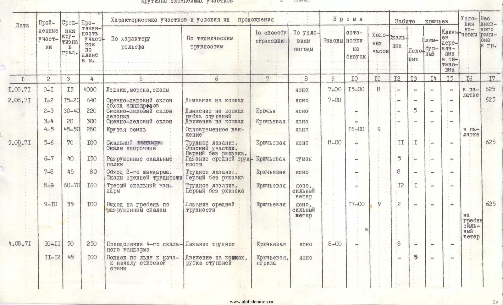
| Date | Sections traversed | Average steepness in degrees | Length of sections in meters | Characteristics of sections and conditions of passage: By relief | Characteristics of sections and conditions of passage: By technical difficulties | Characteristics of sections and conditions of passage: By belaying method | Characteristics of sections and conditions of passage: By weather conditions | Time: Departure | Time: Bivouac stop | Time: Travel hours | Pitons driven: Rock | Pitons driven: Ice | Pitons driven: Piton hooks | Pitons driven: Wooden and titanium wedges | Bivouac conditions | Daily ration weight in grams |
|---|---|---|---|---|---|---|---|---|---|---|---|---|---|---|---|---|
| 01.08.1971 | R0–R1 | 15 | 4000 m | Glacier, moraine, rocks | clear | 7:00 | 15:00 | 8 | in a tent | 625 | ||||||
| 02.08.1971 | R1–R2 | 15–20 | 640 m | Snow-ice slope, bypass of "gendarme" | Movement on crampons | clear | 7:00 | 625 | ||||||||
| R2–R3 | 30–40 | 220 m | Snow-ice slope, icefall | Movement on crampons, cutting steps | Hook | clear | 5 | |||||||||
| R3–R4 | 20 | 300 m | Snow-ice slope | Movement on crampons | Rope belay | clear | ||||||||||
| R4–R5 | 45–50 | 280 m | Steep talus | Simultaneous movement | clear | 16:00 | 9 | in a tent | ||||||||
| 03.08.1971 | R5–R6 | 70 | 100 m | Rock "gendarme". Unstable rocks. | Difficult climbing. Hazardous section. First without a backpack. | Rope belay | clear | 8:00 | 11 | 1 | 625 | |||||
| R6–R7 | 40 | 150 m | Destroyed rocky ledges | Climbing of medium difficulty | Rope belay | fog | 5 | |||||||||
| R7–R8 | 45 | 80 m | Bypass of the 2nd "gendarme". Rocks of medium difficulty | Difficult climbing. First without a backpack. | Rope belay | clear | 8 | |||||||||
| R8–R9 | 60–70 | 160 m | Third rock "gendarme" | Difficult climbing. First without a backpack. | Rope belay | clear, strong wind | 12 | 1 | ||||||||
| R9–R10 | 35 | 100 m | Exit to the ridge via destroyed rocks | Climbing of medium difficulty | Rope belay | clear, strong wind | 17:00 | 9 | 2 | on the ridge, strong wind | 625 | |||||
| 04.08.1971 | R10–R11 | 50 | 250 m | Overcoming the 4th rock "gendarme" | Difficult climbing | Rope belay | clear | 8:00 | 8 | |||||||
| R11–R12 | 45 | 100 m | Approach via ice to the beginning of the sheer wall | Movement on crampons, cutting steps | Rope belay, fixed ropes | clear | 5 | |||||||||
| R12–R13 | 80 | 40 m | Rock wall, with an overhanging plug at the top | Very difficult climbing. Using ladders. Backpacks are pulled up. | Rope belay | clear | 7 | 1 | 2 | 1 | ||||||
| R13–R14 | 90 | 40 m | Ascent via a smooth wall with overhangs in the upper part | Very difficult climbing. Using ladders. Backpacks are pulled up. | Rope belay | clear | 8 | 5 | 3 | |||||||
| R14–R10 | Descent to the bivouac along the 5500 m ridge | Via the ascent path | Rope belay | clear | 19:00 | 11 | in a tent | |||||||||
| 05.08.1971 | R10–R0 | Descent to the base camp | Via the ascent path | Rope belay | clear | 6:00 | 18:00 | 12 | ||||||||
| ASSAULT | ||||||||||||||||
| 09.08.1971 | R0–R1 | Exit to the col (4900 m) | Glacier, rocks | clear | 7:00 | 15:00 | 8 | in a tent | 600 | |||||||
| 10.08.1971 | R1–R10 | Snow-ice slope. Overcoming "gendarme". | Movement along the processed route. | Rope belay | strong wind with dust ("Afghani") | 7:00 | 17:00 | 10 | 4 | 4 | in a tent | 600 | ||||
| 11.08.1971 | R10–R14 | Ice slope. Sheer rocks | Movement along the processed path, suspended fixed ropes (90 m), backpacks are pulled up. | Rope belay | strong wind, snow | 9:00 | 18:00 | 9 | 5 | 2 | 1 | 2 | in a tent on an inclined ledge, tent and participants are secured with pitons | 600 | ||
| 12.08.1971 | R14–R15 | 35 | 50 m | Inclined ledge with formed ice | Difficult climbing. | Rope belay | fog | 10:00 | 4 | 1 | 600 | |||||
| R15–R16 | 40 | 80 m | Black rocks | Difficult climbing. First without a backpack. | Rope belay | clear | 11 | |||||||||
| R16–R17 | 45 | 80 m | Rocks of slab-like structure | Difficult climbing. First without a backpack. | Rope belay | clear | 13 | |||||||||
| R17–R18 | 65 | 40 m | Rock wall. Exit below the second quartz belt. | Very difficult climbing. Backpacks are pulled up. | Rope belay | clear | 19:00 | 9 | 8 | 1 | 2 | in a tent. Platform made of stones. | ||||
| 13.08.1971 | R18–R19 | 45 | 160 m | Exit to the quartz belt | Difficult climbing. | Rope belay | clear, strong wind | 9:00 | 8 | 550 | ||||||
| R19–R20 | 50 | 160 m | Movement along the quartz belt. In the upper part, formed ice. | Very difficult climbing. | Rope belay | clear, strong wind | 14 | 2 | ||||||||
| R20–R21 | 60 | 80 m | Exit from the quartz belt. Destroyed rocks. | Very difficult climbing. First without a backpack. | Rope belay | clear, strong wind | 12 | 2 | ||||||||
| R21–R22 | 25 | 80 m | Destroyed rocks. Movement along the ridge. | Climbing of medium difficulty. | Rope belay | clear | 19:00 | 10 | 2 | in a tent | ||||||
| 14.08.1971 | R22–R23 | 35 | 160 m | Formed ice with a thin layer of snow | Movement on crampons, cutting steps | Rope belay | clear | 9:00 | 8 | 550 | ||||||
| R23–R24 | 45 | 180 m | Ice covered with a thin layer of snow | Movement on crampons | Rope belay | clear | 4 | |||||||||
| R24–R25 | 45 | 120 m | Hard snow, bypassing rock outcrops | Movement on crampons | Rope belay | cloudy | 2 | 4 | ||||||||
| R25–R26 | 55 | 80 m | Exit via a steep glacier to the summit ridge | Movement on crampons, cutting steps | Rope belay | 5 | ||||||||||
| R26–R27 | 25 | 100 m | Exit to the summit via loose snow | Movement on crampons | Through an ice axe | clear | ||||||||||
| R27–R28 | Descent via E. Abalakova's route, category 4B | 2 rappels of 40 m via ice. Initially movement on crampons, then simultaneous. | Rope belay, through an ice axe on snow, through outcrops on rocks | cloudy | 19:30 | 10.5 | 1 | 4 | in a tent | |||||||
| 15.08.1971 | R28–R1 | Descent from the ridge to the icefall. Then via the icefall to the 4900 m col. | 1 rappel of 40 m via rocks, 7 rappels via ice, following E. Abalakova's route. | Clear path of ascent | 9:00 | 19:00 | 10 | 3 | 8 | in a tent | 550 | |||||
| 16.08.1971 | R1–R0 | Descent from the col to the base camp | Via the ascent path | slight cloudiness | 10:00 | 14:00 | 4 | in a tent | 550 |
TOTAL ON ASCENT: 1. Travel hours — 97 (including 35 hours for cache deployment) Pitons driven — 206 of which: rock — 144 ice — 43 piton hooks — 9 wedges — 10 TOTAL ON DESCENT: 1. Travel hours — 30.5 (including 14 hours during cache deployment) Pitons driven — 16 of which: rock — 4 ice — 12 piton hooks — 0 wedges — 0