
MOS DSO «ZENIT»
Route Description
TO THE SUMMIT «LITVA» (6080 m) VIA THE SOUTHWEST FACE (first ascent)
Southwestern Pamir 1972
Group Composition

Chapter II. Ascent Execution
I. Route Description
Day I — August 5, 1972. Departed from the base camp located in the Kishti-Dzherob valley at an altitude of about 4200 m above sea level at 16:00.
Initially, the path goes along the left side of the river, and then, after crossing to the right side, follows a well-defined trail leading up the valley towards the «4700» campsite and the «5200» pass. Before reaching the «4700» campsite, crossing the left (orographically) tributary of the Kish-ty-Dzherob River, which flows from the Litva glacier, we moved along its left (in the direction of travel) side and ascended to its left (in the direction of travel) steep bank, where we stopped at a bivouac on a relatively flat plateau at 19:00.
The bivouac site, referred to as the «observation point» hereafter, is convenient because it allows for direct radio visibility with both the base camp and most of the routes in the valley. Therefore, it was used by the team as an observation point.
Day II — August 6, 1972. A day of observing the route and maintaining intermediate radio communication between the teams on the routes to the «Moskovskaya Pravda» peak and the Danilaimisa peak, and the base camp.
Day III — August 7, 1972. At 9:00, we left the «observation point» bivouac and, moving along the left (in the direction of travel) side of the river flowing from the Litva glacier, ascended to its upper reaches. We crossed the glacier to the right (in the direction of travel) and approached the sheer southwest walls of the Litva peak.
 Then, gaining altitude, the path follows scree and snowy slopes towards the couloir separating the masses of the Babel and Litva peaks. Before reaching the couloir, the path turns sharply upwards and leads to a rocky ridge. Here, at 14:00, we established a bivouac — the «Assault Camp» practically at the level of the lower campsites under routes 5A and 5B category of difficulty on the Babel peak.
During the approaches and throughout the rest of the day, we observed the regime of the wall and refined the route. We identified areas of rockfall and planned safe paths to approach the start of the route.
As a result of reconnaissance and observations, it was decided to start the route the next day. However, during the evening radio communication, an instruction was received from the senior coach of the gathering and the release officer, Mr. Mishin A.F., to postpone the start of the route by one day due to:
- loss of radio contact with the Chekhovsky group;
- unforeseen delay of this group on a non-classified route of 4B category of difficulty on the Litva peak.
Day IV — August 8, 1972. A forced rest day. From early morning, observation was established on the route of 4B category of difficulty on the Babel peak, which continued until 11:00. At this time, the Chekhovsky group was spotted descending from the upper campsite under the route 5A category of difficulty on the Babel peak.
It made no sense to start the route in the middle of the day due to increased rockfall hazard on the path under the wall and the initial section of the route on the wall.
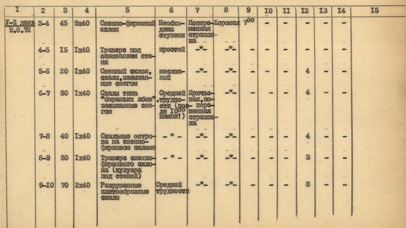
Day V — August 9, 1972. Departure from the bivouac at 7:00. The path (R3–R4) lies across a snowy slope with a slope of about 45° to the base of the southwest wall (5x40 m). Further (R4–R5), moving under the wall's cliffs (40 m), we approach a scree ridge branching off from the wall — here is the first control point, indicating the start of the wall section of the route.
From the control point (R5–R6), traversing 40 m of a snowy slope under the wall's cliffs with a gain in altitude, we approach rocks resembling «ram's foreheads». Further (R6–R7), we ascend 40 m up rocks resembling «ram's foreheads», covered with snow, leaving a snowy couloir to the left.
The couloir (R7–R8) is crossed via rocky outcrops 40 m under the base of a concave sheer wall. This section should be passed quickly and with heightened vigilance, as rocks are dislodged from the wall after 10:00.
Further (R8–R9), the path goes under the cliffs of the monolithic wall to the left and leads via a snowy-firn slope 40 m to under broken slab-like rocks. Movement on the next section of broken rocks (R9–R10) requires increased caution due to possible rockfall caused by a partner's actions.
The section (R10–R11) represents a 40 m traverse to the right with a gain in altitude across broken slab-like rocks. This «oblique» traverse leads under an overhanging rocky wall, to the left of which the path (R11–R12) goes up a steep sheer chimney, at the top of which is a «cork». When passing to the left of the «cork», a piton was hammered, and two ladders were used. This section is very difficult and requires thorough piton protection.
Passing the chimney at 19:00 concludes the exit to a snowy shelf, where a normal bivouac is established. Here, a station is also set up for hauling backpacks. It should be noted that so far, no more suitable place for a bivouac has been encountered.
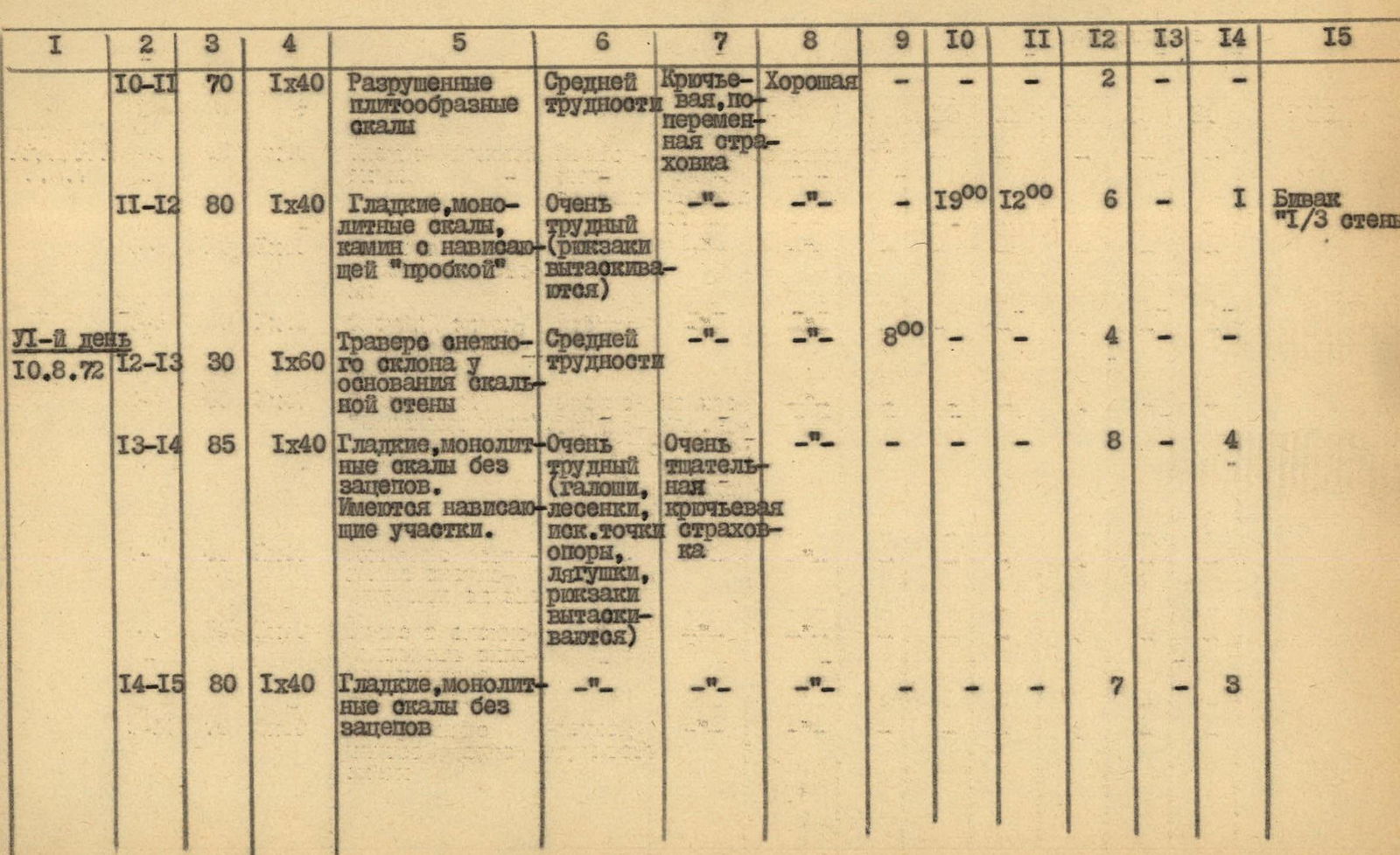
Day VII — August 10, 1972. Departure at 8:00. We face an almost sheer wall. We plan to pass no more than five ropes today to reach a possible bivouac site in daylight, which was previously observed from the observation point and the assault camp.
At this time, the rocks are still «cold», and we have to climb in galoshes and, of course, without backpacks. However, there is no time to wait, and we have to endure a bit.
We choose the most convenient path to start the ascent. To do this, we traverse (R12–R13) across a steep snowy slope under the wall's base to the right for 60 m. Protection is piton-based.
Work on the wall begins with passing an overhanging section at the very beginning of the path (R13–R14), using a classic technique where one participant stands on the shoulders of another. These 40 m are perhaps one of the «key» sections of the wall, if not the ascent. Climbing is very complex and tense — only in galoshes and without backpacks. It is necessary to drill, as there are no holds, and ladders and jammers must be used. The altitude significantly affects the difficulty. This rope takes a good three hours for the first climber.
However, it is no easier further on, as the path (R14–R15) turns left and goes along the wall with a traverse and a gain in altitude. The nature of the section:
- the same smooth rocks;
- climbing is very complex.
Here — at point R15 — we manage to find a minimal ledge for organizing a station for receiving backpacks. For convenience, we haul the backpacks not along the route's path but slightly to the left, directly down for about 50 m.
The further path (R15–R16) goes vertically upwards for 40 m along a weakly expressed chimney with accreted ice and overhanging «forehead» at the top. The section is very difficult, requiring careful protection and creation of artificial points of support. It is necessary to chop ice in search of cracks for pitons. Here, four pitons are hammer should be driven, and five ladders are hung.
After exiting the overhanging section of the wall, a station is organized for hauling backpacks to a depth of about 30 m.
The next section (R16–R17) passes along the continuation of a vaguely expressed chimney, turning into a destroyed crack in the rocky wall. Climbing is complex. There is a heightened danger of rockfall caused by the rope or a partner's actions. Maximum caution is required.
At the end of this section, there is no possibility of:
- hammering pitons;
- securing the rope, so it is necessary to drill. Backpacks still have to be hauled.
Further on, the path unexpectedly leads to a small triangular platform (resembling a ship's bow), attached to the formidable wall. With great joy, we organize the second bivouac on the wall at 23:00.
This was perhaps the most difficult day, and we passed the key section of the wall.
Day VIII — August 11, 1972. Departure of the first pair at 9:00. The work ahead is long, so the second team is not in a hurry to dismantle the bivouac. The section (R17–R18) 40 m begins directly from the bivouac to the left of the overhanging rusty part of the wall along the edge of a rocky «flake». Climbing is complex. The pair has to work without backpacks in galoshes and, of course, on a double rope. It was immediately clear that carrying backpacks along such a wall is, to put it mildly, not rational, and it's not possible to carry them. After all, we're under 6000 m, and the altitude is taking its toll.
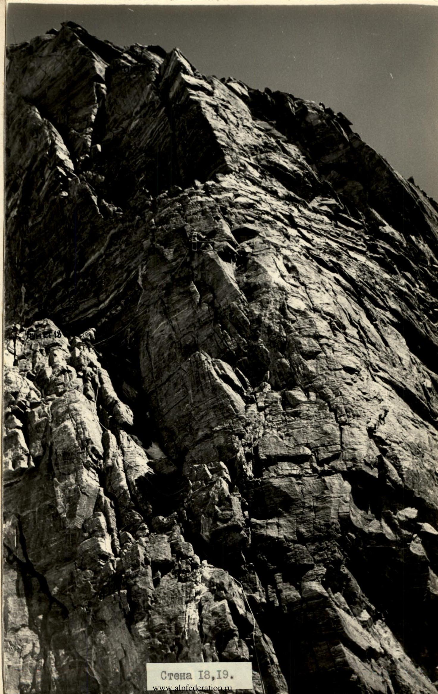 Wall R18, R19.
At the point where the «flake» ends, it is possible to receive a partner. Further movement goes upwards to the right (R18–R19) along a monolithic wall, at the top of which there is a vertical slit. Three ladders are used. Climbing is very complex, sometimes having to go just on friction, and in this case, galoshes are indispensable.
We decide to haul backpacks not in two stages but to organize a reliable station at point (R19) and haul them directly from the bivouac (point R17). To do this, we have to lengthen the rope.
The path along the wall is so logical that there is no desire to get lost.
At point (R19), all participants gather at 16:00. Further, the path (R19–R20) goes along an internal rocky angle, turning into stepped boulder-like rocks.
Climbing is still complex, as it is necessary to overcome sheer sections of 2–5 m with minimal holds.
The next section (R20–R21) passes along destroyed inclined slabs and leads to a relatively gentle counterfort descending from the ridge of the Litva peak massif.
Here, at 20:00, we stop at a bivouac, almost on the edge of the wall, as there is something to build a platform for setting up a tent.
Day IX — August 12, 1972. Departure time is 9:00. The path (R21–R22) goes along a snowy ridge with rocky outcrops. This ridge turns into a counterfort (R22–R23), leading to the main ridge of the Litva peak. Movement is along steps, with alternate protection. Further (R23–R24), the path goes along a snowy-rocky ridge of the Litva peak to the summit. We reached the summit at 12:00.
We began the descent at 12:30. The descent path is logical, as it mainly follows the ridge towards the col between the Babel and Litva peaks. However, it is necessary to be very attentive, as there are sections where it is necessary to cross the ridge line, moving from one face to another.
Using rappels and sport descents, we descended into the couloir from the col and were at the upper campsite under the route 5A category of difficulty on the Babel peak at 17:00. From there, we returned to the base camp via the usual approach path to the Babel peak at 20:00.
2. Table of Main Route Characteristics
| Day / Date | Section | Slope (°) | Length (m) | Relief | Difficulty | Protection | Weather | Departure | Bivouac | Working hours (ч) | Rock Pitons | Ice Pitons | Piton Hammers | Note |
|---|---|---|---|---|---|---|---|---|---|---|---|---|---|---|
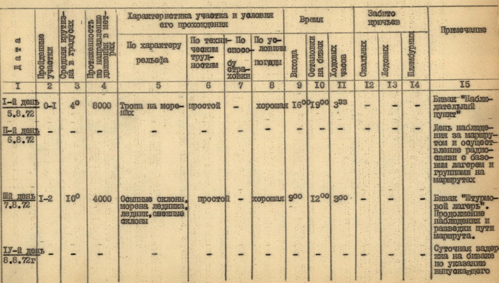
| Day I August 5, 1972 | R0–R1 | 40 | 8000 | Trail on moraines | simple | – | good | 16:00 | 19:00 | 3:30 | – | – | – | Bivouac «Observation Point» |
| Day II August 6, 1972 | – | – | – | – | – | – | – | – | – | – | – | – | – | Day of observing the route and maintaining radio communication with the base camp and groups on routes |
| Day III August 7, 1972 | R1–R2 | 10 | 4000 | Scree slopes, moraine of the glacier, glacier, snowy slopes | simple | – | good | 9:00 | 12:00 | 3:00 | – | – | – | Bivouac «Assault Camp». Continuing observation and reconnaissance of the route path. |
| Day IV August 8, 1972 | – | – | – | – | – | – | – | – | – | – | – | – | – | Day of forced rest at the bivouac as per the release officer's instruction |
| Day V August 9, 1972 | R3–R4 | 45 | 5x40 | Snowy-firn slope | Steps necessary | Alternate protection | good | 7:00 | – | – | – | – | – | – |
| R4–R5 | 15 | 1x40 | Traverse under the wall's base | simple | – | – | – | – | – | – | – | – | – | |
| R5–R6 | 20 | 1x40 | Snowy slope, rocks covered with snow | not difficult | – | – | – | – | – | 4 | – | – | – | |
| R6–R7 | 50 | 1x40 | Rocks like «ram's foreheads», covered with snow | medium difficulty (after 10:00 rocks fall!) | Alternate protection | – | – | – | – | 4 | – | – | – | |
| R7–R8 | 40 | 1x40 | Rocky outcrops on a snowy-firn slope | – | – | – | – | – | – | 4 | – | – | – | |
| R8–R9 | 50 | 1x40 | Traverse of a snowy-firn slope (couloir under the wall) | – | – | – | – | – | – | 3 | – | – | – | |
| R9–R10 | 70 | 2x40 | Broken slab-like rocks | medium difficulty | – | – | – | – | – | 8 | – | – | – | |
| R10–R11 | 70 | 1x40 | Broken slab-like rocks | medium difficulty | Piton, alternate protection | good | – | – | – | 2 | – | – | – | |
| R11–R12 | 80 | 1x40 | Smooth, monolithic rocks, chimney with an overhanging «cork» | very difficult (backpacks hauled) | – | – | – | 19:00 | 12:00 | 6 | – | – | Bivouac «1/3 of the wall» | |
| Day VII August 10, 1972 | R12–R13 | 30 | 1x60 | Traverse of a snowy slope at the base of the rocky wall | medium difficulty | – | – | 8:00 | – | – | 4 | – | – | – |
| R13–R14 | 85 | 1x40 | Smooth, monolithic rocks without holds. Overhanging sections present. | very difficult (galoshes, artificial holds, ladders, backpacks hauled) | Careful piton protection | – | – | – | – | 8 | – | 4 | – | |
| R14–R15 | 80 | 1x40 | Smooth, monolithic rocks without holds | – | – | – | – | – | – | 7 | – | 3 | – | |
| R15–R16 | 90 | 1x40 | Weakly expressed chimney ending in an overhanging ice block («cork»). Rocks are smooth, sheer, without holds | very complex climbing (galoshes, ladders, artificial holds, jammers, backpacks hauled) | – | – | – | – | – | 12 | 2 | 4 | – | |
| R16–R17 | 75 | 1x30 | Vertical crack in the wall | complex climbing (backpacks hauled) | – | – | – | 23:00 | 15:00 | 6 | – | 2 | Bivouac «on the ship's bow» | |
| Day VIII August 11, 1972 | R17–R18 | 80 | 1x40 | Flake of a monolithic rocky massif | complex climbing (galoshes, ladders, backpacks hauled) | – | – | 9:00 | – | – | 7 | – | – | – |
| R18–R19 | 85 | 1x40 | Monolithic wall with a vertical slit | very complex climbing (galoshes, ladders, backpacks hauled, artificial holds) | – | – | – | – | – | 9 | – | – | – | |
| R19–R20 | 75 | 1x40 | Internal rocky angle, stepped boulder-like rocks | complex climbing | Combined (piton + ledge) protection | – | – | – | – | 6 | – | – | – | |
| R20–R21 | 60 | 1x40 | Slab-like destroyed rocks | medium difficulty | Protection through ledges | – | – | 20:00 | 11:00 | 3 | – | – | Bivouac «End of the wall» | |
| Day IX August 12, 1972 | R21–R22 | 30 | 3x40 | Snowy-firn ridge with rocky outcrops | – | Alternate protection | – | 9:00 | – | – | 1 | – | – | – |
| R22–R23 | 40 | 3x40 | Destroyed rocks of the counterfort descending from the ridge | – | – | – | – | – | – | 2 | – | – | – | |
| R23–R24 | 15 | 7x40 | Rocky ridge of the Litva massif, with pure snowy sections | – | – | – | – | 12:30 | 12:00 | 3:00 | 1 | – | – | |
| R24–R25 | -20 | 15x40 | Snowy-rocky ridge. Rocks are destroyed | – | – | – | – | 15:00 | 15:00 | 2:30 | 5 | – | – | |
| R25–R26 | -80 | 2x40 | Sheer, icy rocks | Rappelling | Piton protection | – | – | – | – | 6 | – | – | – | |
| R26–R27 | -50 | 2x40 | Snowy couloir | Sport descent | – | – | 17:00 | 17:00 | 2:00 | 2 | – | – | Bivouac under route 5A on Babel peak | |
| R27–R28 | Return to the base camp via the usual approach path to route 5A category of difficulty on Babel peak | – | – | – | – | 20:00 | 3:00 | – | – | – | Base camp | |||
| Total: | 54:30 | 110 | 2 | 14 |
Conclusion
The group completed a complex combined route that corresponds to the 5B category of difficulty in terms of complexity and difficulty of passage.
It represents a wall with a slope of up to 90°, which can be conditionally divided into three parts (by bivouacs). Its middle part, located at altitudes of 5600–6000 m, is the «key» to the entire route, as it combines classic difficulties of overcoming complex sheer walls with their relatively high location above sea level.
The rocks are mostly monolithic, smoothed, and boulder-like. On such rocks, it is rational for all participants to climb in galoshes if weather conditions permit.
The overall height difference of the route is about 1200 m. The length of complex and very difficult (sheer and close to sheer) sections is about 200 m, and these sections are located at altitudes of 5700–5900 m.
The route requires a wide range of rock pitons, organization of artificial points of support, and hauling of backpacks. In some places on the route, it is not possible to organize reliable protection without resorting to hammering pitons.
The set of equipment and supplies presented in the report has generally proven itself and can be recommended for passing this route.
The locations of bivouacs chosen by the group during the passage of the wall route corresponded to the tactical plan, are objectively safe, and are perhaps the only possible ones for optimal and reliable movement along the route. The entire ascent took 54.5 working hours. Of these, 10.5 hours were spent on approaches and return to the base camp.
The entire ascent took 8 calendar days, including:
- one day for approaches;
- two days for observation and reconnaissance;
- one day for a forced rest day under the wall;
- three and a half days for passing the wall route;
- half a day for descent from the summit and return to the base camp.
On the route, excluding bivouac organization, 126 pitons were hammered. Including:
- 110 rock pitons;
- 2 ice pitons;
- 14 piton hammers.
The weather throughout the ascent was good and allowed the wall section of the route to be passed in galoshes.
As recommendations, it should be noted that it is advisable to use 50-meter main ropes on the rocky part of the route both for climbing and for hauling backpacks, as well as the fact that there was no direct need to use crampons during the ascent.
In conclusion, it should be said that the route passed is beautiful, logical, and objectively safe.
SENIOR COACH OF THE GATHERING (MISHIN) TEAM LEADER (PENCHUK) PARTICIPANTS
- (KORSUN)
- (KURSHIN)
- Vrumentu (KREMINA)
- (GLADCHENKO)