
Report
On the first ascent to the summit of Asham 5982 m via the SW wall, category 5B difficulty.
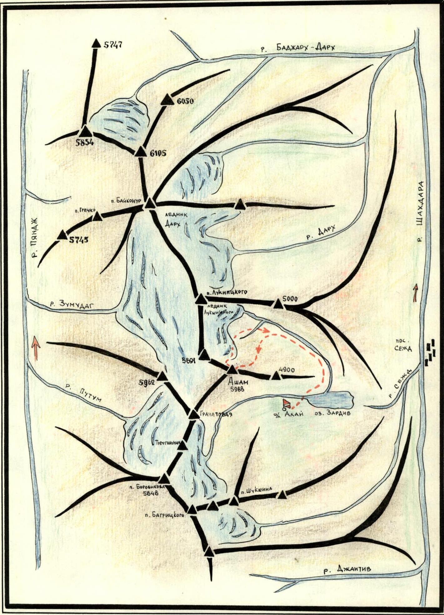
South-Western Pamir, Shakhdarin Range.
MOSCOW 1977
Map of the Area
Brief Geographical Description of the Area and Climbing Conditions
The Asham peak, 5982 m, is located in the western part of the Shakhdarin Range in the South-Western Pamir, between the peaks p. Granatovyi 5700 m to the east and Bezymanaya 5891 m to the west.
The Luknitskiy glacier, which is relatively calm, flows from the cirque formed by the peaks Asham, Bezymanaya, and p. Luknitskiy. The flow of this glacier feeds into Lake Zardiv, which is one of the sources of the Sezh river that flows into the full-flowing Shakhdara near the settlement of Sezh.
On the northern side of the Asham peak lies a cirque formed by the peaks:
- p. Granatovyi 5700 m
- p. Treugolnik
- p. A. Borovikov 5848 m
- Uzlovaya 5770 m
- and others.
The flow from this cirque, with its glacier, is the second source feeding Lake Zardiv. The approach to the Asham peak from the settlement of Sezh, which has good motor roads, follows convenient pack trails.
Under the southern walls of the large cirque formed by the peaks:
- Asham,
- Baykonur,
- p. Grechko,
- p. Luknitskiy, — lie the Zugmund and Putup glaciers; their rivers with the same names flow into the Pyanj river.
In 1904, the area was visited by B. A. Fedchenko on an expedition, who first described it in the "Izvestiya" of the Imperial Botanical Garden. Seventy years later, in 1974, reconnaissance climbers led by V. Nekrasov, a Master of Sports of the USSR, first appeared in the area and began the mountaineering development of the region. In 1975 and 1976, climbers from the Armed Forces of the USSR, as part of the Soviet Championship, climbed the walls of p. Luknitskiy and ascended p. Luknitskiy via the NW ridge, rated category 5B difficulty. Most other peaks remained untouched until 1977.
The harsh, demanding serious technical and especially tactical preparation, northern and southern walls were targeted for ascent by the "Spartak" MGS expedition in 1977.
The weather conditions in the area are favorable for mountaineering, similar to the rest of the South-Western Pamir.
Brief Characteristics of the Climbing Object
The Asham peak, 5982 m, is located in a spur of the western part of the Shakhdarin Range. It is one of the majestic peaks in the area. The most complex routes are visible from the north. Interesting mountaineering routes are also available from the side of p. Luknitskiy, particularly the SW wall of the western ridge of Asham, which presents itself as an amphitheater with steep, sheer cliffs on the left and right, especially on the right part. The middle part of the amphitheater is a fairly wide wall interspersed with smooth rocks and clearly defined three horizontal belts separated by ledges.
The chosen route is combined: it includes several snow-ice sections, rock sections with verglas, and a purely rock section. The exit from the ridge of the wall to the summit is a steep snow-ice dome.
The route chosen by the group is of significant sporting interest and demands high proficiency in various mountaineering techniques to overcome technically complex sections of the route (ladders, ITI, rope hauling, verglas sections, etc.).
Upon climbing the SW wall, the route chosen by the group proved to be the most logical, as confirmed by other groups that followed the same route.
The ascent and all organizational matters practically coincided with the planned tactical plan. Previously planned sections of the route for each day also matched the group's actual work on the route. Therefore, it can be considered that the ascent plan was fully executed according to the preliminary outline made during the route reconnaissance and planning.
Route Description
To clarify the passage of key sections of the SW wall route, team leader Klimashin V. and Zybin A. went to the opposite slopes of the SW wall ridge and observed the wall's condition, possible rockfall paths, and route options through binoculars for a day. Based on the observations and sketches made, the tactical plan for the ascent was refined and approved at the coaches' council in the base camp.
July 16, 1977
In the second half of the day, the group left the base camp and, following the left side of the river flowing from the Luknitskiy peak glacier, approached the grassy slopes with black large scree at the beginning of the ascent under the SW wall cirque of the Asham peak.
They set up a bivouac on the right grassy clearing among the glossy-black large scree near transparent streams flowing through the clearing.
Final observations and clarifications before exiting to the wall.
July 17, 1977
Section R0–R1
From the bivouac, the ascent initially follows steep grassy slopes and scree towards the snowy slope. Then, the ascent continues up the snowy slope before the SW wall to a clear tongue at the base of the wall, to a slanting internal angle (right to left upwards), with rocks having verglas on the left. Steep, through smoothed rocks, the steep internal angle is traversed with a niche — caution!!! Icicles are hanging from above!!! Exit to an inclined scree ledge.
Section R1–R2
Along a wide inclined scree ledge with many loose rocks (simultaneous movement), we approach the rocks. The further path is visible through a clearly defined crack. Water flows through the crack.
Section R2–R3
- Approximately 30 m up the wet crack.
- Rocks of medium difficulty, destroyed.
- Protection through individual large protrusions and pitons.
Climbing is complicated by verglas covering small cracks and holds.
Section R3–R4
The crack flattens out at the top and leads to a scree ledge. Movement along an inclined scree ledge about 40 m under steep rocks, transitioning into smooth walls cut by large cracks.
Section R4–R5
To the right, bypassing a clearly defined rock tower, via short walls (steep, piton protection). Movement requires caution due to heavily destroyed rocks and numerous loose stones.
Section R5–R6
The walls lead to a narrow ledge, from which about 40 m of complex climbing under an overhanging section like a "visor" and to the right-upwards traverse (attention!!! gets thrown off!!!) leads to a platform where the whole group can gather. The section where one gets thrown off was first passed without a backpack. The section is complex, rocks are smoothed, and it's advisable to pass it in "vibram" boots.
Section R6–R7
From the platform, along smoothed, fairly steep rocks resembling a ladder made of small "sheep's foreheads," upwards about 80 m.
Many loose stones, small scree debris lying on "sheep's foreheads."
Climbing is unpleasant and very cautious due to this.
Protection:
- through individual protrusions,
- piton — difficult.
Section R7–R8
Further ascent follows an internal angle-crack approximately 120 m upwards. Rocks are heavily destroyed, many loose stones. Piton protection.
Section R8–R9
We exit onto a wide scree ledge, movement is simultaneous. One can relax a bit from climbing through loose and destroyed rocks.
Section R9–R10
From the ledge, we approach a clearly defined shoulder on the wall of the counterfort, then to the right-upwards traverse along the wall about 30 m through an internal angle with a stream. The internal angle has verglas. Exit from the angle to a ledge under rocks with a crack.
Section R10–R11
For further ascent, we choose a crack and climb about 30 m up. Climbing is enjoyable, though strenuous. Rocks are solid, monolithic, and protection is reliable.
Section R11–R12
We pass the crack and exit to a small wall. Then, along steep rocks towards (left) a snow patch, leaving a stream and rocks with verglas on the left.
Section R12–R13
Along the snow patch, traversing it to the right, we exit to ярко expressed rocks of "ochre" color and climb about 60 m up to a steep short snow patch. The snow is thin, with ice underneath. Step cutting in very solid ice.
Section R13–R14
From the snow patch upwards (steep) towards a crack and then to the right along it 40 m to a ledge. The weather worsened, snow started falling, and it became overcast. Dry snow quickly fills cracks and depressions, greatly hindering the search for protrusions for movement and climbing.
Section R14–R15
From the ledge, left-upwards under steep foreheads like short walls. Along smooth "foreheads," we climb about 20 m upwards and then along destroyed rocks with numerous loose stones. Climbing is very cautious.
Section R15–R16
Along an inclined scree ledge left-upwards and through an internal angle, we exit towards a shoulder with a couloir to large blocky rocks. From here, the path to the end of the wall is fairly clear. It's a scree couloir with many loose stones.
Section R16–R17
Up the couloir and несложным destroyed rocks a bit to the left of the direction, we ascend towards a large "gendarme." From afar, on the ridge, it resembles a submarine's conning tower in its outline. We exit onto the ridge to the left of the "gendarme." On the shoulder of the ridge, we set up a bivouac and build a cairn. A platform is laid out for a comfortable overnight stay, with snow in abundance for water preparation. The first day's work is complete, and the plan is fully executed.
July 18, 1977
Section R17–R18
Ascent at 7:00. Cold, the "gendarme" hides the tent from the sun. From the bivouac, bypassing the "Submarine" to the right along an inclined scree ledge about 120 m. Simultaneous movement allows for gradual warming up and getting into the work. One wants to reach the ridge and the sun as soon as possible.
Section R18–R19
The ledge abuts against destroyed short rocks with a transition to steep rocks of the second "gendarme." Rocks are черепицеобразные (like roof tiles), climbing is difficult, steep, and protection is challenging. It takes a long time to find places for piton placement. Climbing is very complex due to the structure of the rocks.
Section R19–R20
Along a not-deep internal angle of the "gendarme" and further along steep rocks and a narrow crack onto a destroyed wall, then to the top of the "gendarme" and to a saddle in the ridge before the next "gendarme." Snowfall the previous month hinders movement and finding places for protection setup.
Section R20–R21
We exit practically onto the ridge of the "gendarme." The second "gendarme" appears more massive than the previous one. We climb about 80 m straight up (head-on) through difficult rocks (steep 80°) with verglas (very difficult climbing) and finally exit onto the "gendarme's" dome. From here, the path along the ridge to the next "gendarme" is clearly visible.
Section R21–R22
We pass a steep snowy ridge with outcrops of черепицеобразные rocks (under the snow — ice!!!). Cracks and crevices are filled with verglas, many embedded small and large loose stones. It's difficult to organize protection.
Section R22–R23
We exit onto the "gendarme's" tower and further along steep snow through 20 m exit onto the ridge and along it, through heavily destroyed rocks and a narrow ridge, we exit onto a saddle before ascending to the summit part of Asham.
On the saddle, a good platform for a tent made by первовосходителями (first ascenders) is visible. We decide to stop here, as the plan for the second day is also fully executed, and from here, we can examine the further path to the summit and conduct reconnaissance.
July 19, 1977
Section R23–R24
At 7:00, we exit. The sun is shining. The previous day, the route was thoroughly examined, and now it doesn't raise doubts. Along the pre-summit ridge and steep destroyed rocks filled with verglas, we exit to the ice slope of the pre-summit tower of Asham.
Section R24–R25
Ascent with step cutting and ice screws along the ice slope to the right upwards to a small shoulder before a sheer internal angle. The place is unpleasant, psychologically, as almost the entire depth of the wall is visible from here, and there's no bypass.
Section R25–R26
Section R26–R27
The internal angle, climbing is complex, walls are smooth, holds are only at the top. The angle leads to a steep snow-ice slope of the summit dome (Sec. R26–R27). Under a thin layer of snow — ice!!! Ascent along it to the summit plateau (3 snow.) and further to the summit. To the left of the direction, there are cornices!!!
A cairn is to the right on rock outcrops. Descent from the summit follows a destroyed ridge towards the Uzlovaya peak. In the lowering of the ridge, we set up a bivouac, as time doesn't allow for continuing the descent. Below, on the glacier, we see the descending первовосходителей (first ascenders).
We prepare a place for the tent and cook a delicious dinner.
July 19, 1977
In the morning, ascent from the saddle onto a "gendarme" and further along the ridge to a steeply descending couloir (to the right downwards) under the walls of the slopes of v. Uzlovaya. Descent along snowy fields, bypassing crevasses of the glacier, and along it to the moraine in the gorge of p. Luknitskiy and to the base camp by Lake Zardiv.
NOTE: The ascent to the western ridge via the SW wall is complicated by heavily destroyed rocks, numerous loose stones, and their spontaneous fall. There are extended sections of verglas, especially in internal angles and couloirs.
| Date | Sec. | Avg. Steep. | Length in m. | Relief Char. | Diff. | Condition | Weather | Pitons | Exit and Biv. — hrs. |
|---|---|---|---|---|---|---|---|---|---|
| rock | ice | ||||||||
| 1st day | |||||||||
| R0–R1 | 70° | 40 m | internal angle | 5 | verglas | clear | 4 | – | |
| R1–R2 | 30° | 40 m | ledge | 2 | scree | clear | simultaneous | ||
| R2–R3 | 50° | 30 m | crack | 3 | verglas | clear | 1 | – | |
| R3–R4 | 30° | 40 m | ledge | 2 | scree | clear | alternate protection | ||
| R4–R5 | 70° | 40 m | wall | 4 | destroyed | clear | 2 | – | |
| R5–R6 | 80–90° | 40 m | smoothed, thrown off | 5 | monolith | clear | 4 | – | |
| R6–R7 | 50° | 80 m | rocks | 4 | loose stones | clear | – | – | |
| R7–R8 | 60° | 120 m | steep destroyed rocks | 3 | destroyed | clear | 3 | – | |
| R8–R9 | 30° | 40 m | ledge | 2 | scree | clear | single | ||
| R9–R10 | 60° | 30 m | wall | 4 | destroyed, verglas | clear | 1 | – | |
| R10–R11 | 60° | 30 m | crack | 4 | monolith, ice | clear | 1 | – | |
| R11–R12 | 60° | 40 m | steep rocks | 4 | monolith | clear | 2 | – | |
| R12–R13 | 50° | 60 m | destroyed rocks "ochre" | 4 | destroyed | clear | – | – | |
| R13–R14 | 60° | 40 m | crack | 4 | monolith | overcast | 2 | – | |
| R14–R15 | 70° | 20 m | wall, "foreheads" | 4 | monolith | overcast, snow | 2 | – | |
| R15–R16 | 60° | 80 m | large blocky rocks | 3–4 | destroyed | overcast, snow | 4 | – | |
| R16–R17 | 45° | 60 m | couloir | 2 | scree, snow | overcast, snow | simultaneous | 17:00, 11 work hrs. |
2nd day
| Date | Sec. | Avg. Steep. | Length in m. | Relief Char. | Diff. | Condition | Weather | Pitons | Exit and Biv. — hrs. |
|---|---|---|---|---|---|---|---|---|---|
| rock | ice | ||||||||
| R17–R18 | 30° | 120 m | ledge | 2 | scree | clear | simultaneous | ||
| R18–R19 | 60–70° | 100 m | slab | 5 | черепицеобразные | clear | 10 | – | |
| R19–R20 | 80° | 15 m | wall | 5 | destroyed | clear | 2 | – | |
| R20–R21 | 80–90° | 80 m | slab | 5 | monolith, verglas | clear, wind | 8 | – | |
| R21–R22 | 50° | 40 m | snow, ice | 4 | – | 3 | |||
| R22–R23 | 30° | 120 m | ridge | 2 | destroyed | clear, wind | simultaneous |
3rd day
| Date | Sec. | Avg. Steep. | Length in m. | Relief Char. | Diff. | Condition | Weather | Pitons | Exit and Biv. — hrs. |
|---|---|---|---|---|---|---|---|---|---|
| rock | ice | ||||||||
| R23–R24 | 60° | 150 m | ridge | 3 | destroyed | clear | 2 | – | |
| R24–R25 | 40° | 80 m | snow-ice slope | 4 | rock outcrops | clear | 3 | 2 | |
| R25–R26 | 90° | 15 m | internal angle | 5 | monolith, ice | clear | 2 | – | |
| R26–R27 | 45° | 200 m | ice slope | 4 | snow, ice | clear | – | 3 | |
| R27–R28 | 5° | 500 m | snow plateau | 1 | snow | clear, wind | simultaneous |