
For the All-Union team championship in alpinism in the class of high-altitude and technical ascents.
Peak Pathor via the south face (first ascent)
Sports team of Tomsk regional sports union.
Team captain (G. Andreev)
Tomsk 1967
Report
on the ascent of Peak Pathor via the south face.
- Geographical location and sporting characteristics of Peak Pathor.
Peak Pathor is located in the central part of the Rushan range in the southwestern region of Pamir. The average height of the range in this area reaches 5500–5600 m. This is where the most significant glaciation node of the Rushan range is located. Its southern and southeastern slopes, facing the Gunt river valley, as well as the northwestern slopes, facing Bartang, are dissected by deep gorges, at the heads of which lie glaciers: Markovsky (Shtselzar), Chapdara, Safedob (southeastern slopes); Gei-Dara, Davlekh, Morsor (northwestern slopes).
Ascents to Peak Pathor (of which there were only three, including this one) were made from the upper reaches of the Markovsky glacier. The Markovsky glacier has a unique structure. It consists of many components stretching in the latitudinal direction, and the glacier tongue is located at the confluence of the western and eastern branches at an altitude of 4000 m.
The slopes surrounding the glacier are dissected by rocky walls, with a relative height of the surrounding ridges and pointed peaks reaching 1.5 km. The snow line in this area lies at an altitude of 4700–4800 m. Climatic conditions are such that the Markovsky glacier is one of the retreating glaciers. It covers an area of more than 50 sq. km and extends 20–25 km from west to east, with 13 main tributaries.
Peak Pathor closes the glacier to the north. It is the highest point of the Rushan range — 6080 m. It crowns a cross-shaped structure formed by four ridges rising to its summit. In addition to the western and eastern ridges — the watershed line of the Rushan range — a rib runs southeast, and a steep counterfort descends to the north.
The path to Peak Pathor follows the Pathor river gorge, which flows into the Gunt river, with a total length of about 20 km (to the tongue of the Markovsky glacier) and a height difference of over 1000 m.
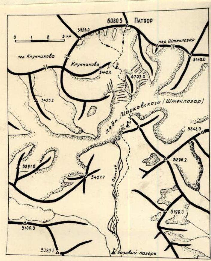
Photo 1. Map-scheme of the Markovsky glacier area (compiled using aerial photography materials). The path of the Tomsk team is marked with a dotted line.
From the base camp near Serebryany stream (3600 m), the path follows the left (orographic) bank of the Pathor river, then the Markovsky glacier, and further through the icefall to the plateau of the upper cirque (4700 m). The sporting interest in this section lies in passing the icefall. This path is well known from the materials of the alpinist expedition of the All-Union Committee for Physical Culture and Sports in 1946. On August 14, 1946, a group led by Beletsky E.A. and Abalakov E.M., consisting of Sidorenko A.F., Ivanov E.I., Tikhonravov V.A., Kolzon A.S., Potapova M.M., Bagrov A., Semenov N.N., Ugarov A.S., Shlyagin I.N., and Staritsky V., ascended to Peak Pathor from the plateau of the upper cirque via the extreme left couloir onto the western ridge and reached the summit.
In 1956, a group from the Turkestan Military District (TurVO) under the leadership of E. Nagel and 10 participants made an ascent, reaching the western ridge via the right, longest snowy couloir (photo 2).
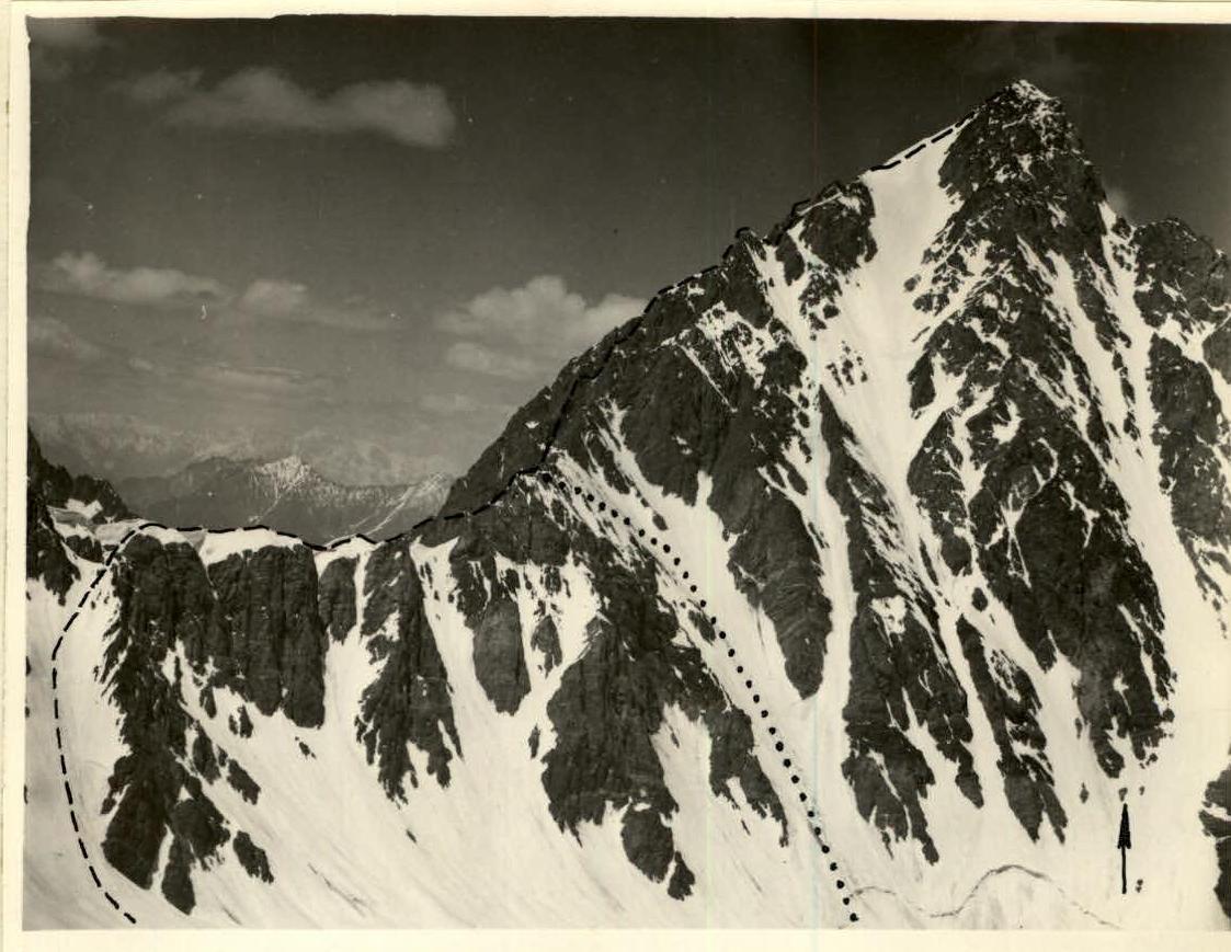
Photo 2. Peak Pathor. The path of the 1946 expedition is marked with a dotted line, the 1956 expedition with dots, and the south face with an arrow.
We chose a different route to Peak Pathor — the south face. The uncharted nature of the route, its logic, and technical complexity were the main reasons for its selection.
2. Climbing conditions
a) Relief. The sharp, pointed contour of the summit, sheer walls almost devoid of snow, sharp ridges with large gaps — all these are characteristic features of the peaks in the area. The rocky relief is favorable for climbing, although the rocks, composed mainly of gray granite, are heavily weathered, requiring careful route selection and study due to the risk of rockfall. From the Markovsky glacier, which is almost completely covered with moraines in its lower and middle parts, the path to the plateau leading to the foot of Peak Pathor lies through a steep and highly mobile icefall (height difference 400 m). The upper cirque has a hilly firn surface. On steep snowy slopes, especially in the southern part, the snowy surface is a forest of small firn calgasporas.
The south face of Peak Pathor, along which the ascent route lay, has a height difference of 1300 m and an average steepness close to 60°. The lower third of the face is sheer (photo 3).
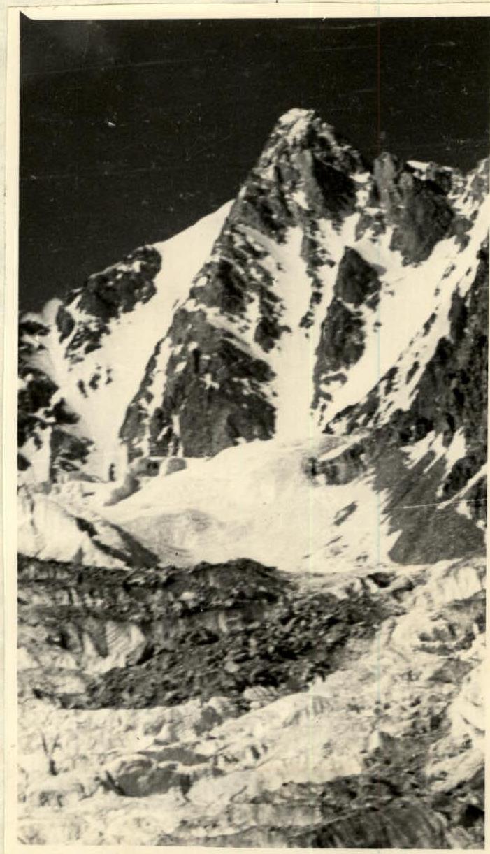
Photo 3. The south face of Peak Pathor is visible in profile.
b) Weather. In July–August, weather conditions are generally favorable. According to the Khorog weather station, there are 2–3 bad weather days during this period. However, longer periods of bad weather with strong winds and low temperatures can occur. At an altitude of 5000 m, nighttime temperatures drop to –15°C, although daytime temperatures in sheltered areas can rise to 15°C. At altitudes close to 6000 m, nighttime and daytime temperatures are significantly lower.
c) Remoteness from populated areas and exploration of the area.
Peak Pathor is relatively close to the Pamir Highway and the village of Von-Kala. Currently, a bridge has been built across the Gunt river, and a car can drive to the village of Pathor at the entrance to the Pathor river gorge. The path along the gorge is passable by pack animals for a distance of no more than 5 km.
Peak Pathor was discovered by geologist S.I. Klunnikov in 1937. As mentioned earlier, the area is rarely visited by climbers. The slopes and glaciers of the Rushan range have been poorly studied. The greatest contribution to the exploration of the Peak Pathor area was made by the alpinist expedition of 1946.
3. Reconnaissance and supply drops.
A. At the beginning of September 1966, a reconnaissance of the area was conducted to assess the feasibility of ascending Peak Pathor via the south face.
B. 1) From May 19 to July 30, 1967, the entire expedition team organized a base camp and intermediate camps at 4100 m and 4700 m, with supplies of food and equipment.
-
On August 1, a training ascent was made by the entire expedition team (16 people) under the leadership of G.G. Andreev to Peak Klunnikov (5442 m), which served as reconnaissance for the intended route to Peak Pathor. The upper part of the route was examined, and possible campsites were identified. It was noted that the lower snowy-ice slopes of the face, as well as the right and left slopes, are constantly exposed to rockfall. The reconnaissance data could not fully answer the questions posed.
-
From August 2–5, round-the-clock observation of the intended route was organized to determine the regime of the face.
On August 4, a group consisting of G.G. Andreev (leader), N.N. D'yachenko, G.N. Kholmansky, and L.K. Spiridonov made a training ascent to the saddle of the western ridge, climbing the first pinnacle. This reconnaissance was necessary to further clarify the details of the upper part of the route and to familiarize themselves with the proposed descent route along the western ridge.
4. Organizational and tactical plans for the ascent.
The reconnaissance data showed that the intended route along the most protruding part of the face was safe from rockfall. Deviating from the route posed a risk due to frequent rockfall in all lateral couloirs, especially in the middle part of the face. Rockfall ceased around 3 am and did not resume until 8–9 am. The passage through the lower part of the route — the snowy-ice slope — was scheduled for this time. The plan was to complete the route in 6–7 days. During the ascent, the group had an 8-day supply of food and fuel. No changes were made to the route during the ascent.
Standard equipment was used during the ascent.
5. Assault team.
According to the application:
Main composition:
- Andreev G.G. — captain
- Kholmansky G.N.
- Kuznetsov E.S.
- D'yachenko N.N.
- Spiridonov L.K.
- Lobanov S.D.
Reserve participants:
- Teterin N.A.
- Gusev B.N.
The following adjustments were made to the assault team:
- Teterin N.A. did not arrive at the gathering (on a business trip);
- Kholmansky G.N. — suffered a sudden attack of radiculitis after a training ascent;
- Lobanov S.D. and Gusev B.N. were removed from the assault team to strengthen the support groups.
Data on the assault team participants:
- Andreev G.G. — born 1934, Russian, non-party, Candidate for Master of Sports, alpinism experience since 1953, junior researcher at TPI.
- D'yachenko N.N. — born 1939, Russian, non-party, Candidate for Master of Sports, alpinism experience since 1958, student at TGU.
- Spiridonov L.K. — born 1937, Russian, non-party, Candidate for Master of Sports, alpinism experience since 1959, assistant at TPI.
- Kuznetsov E.S. — born 1939, Russian, Komsomol member, 1st category sportsman, senior lecturer at TISI.
6. Route passage order
(see profile scheme, photographs, and table)
On August 7 at 6:00 am, the assault team, accompanied by a group of observers led by V.V. Syrkin, left the base camp. After crossing the Pathor river at the point of its divergence into multiple branches, they ascended along the left bank for 6 hours to the intermediate camp at 4100 m, located on the lateral moraine of the Markovsky glacier. From the 4100 m camp, they began their ascent towards the Khitan, bypassing the lower part of the icefall. The ascent through the icefall in its left, most passable part, took 4 hours. At 7:00 pm, the group reached the upper part of the cirque. The total duration of the day's movement was 12 hours. The count for the participants is maintained from the 4700 m camp, from where the assault began.
Route:
On August 8 at 3:30 am, they left the 4700 m camp. After crossing the firn plateau, they began their ascent in crampons along the avalanche cones towards the bergschrund. They passed through it in the narrowest, snow-covered part using the "living ladder" method. After breaking through the upper part of the bergschrund, they emerged onto a 45–50° snowy-ice slope (R0–R1). The movement was hindered by sections of steep serac ice (photo 5), which were passed with some axe work and piton insurance. This was the path of frozen nightly water flows that became torrents during the day. Closer to the rocks, the slope with small firn calgasporas was overcome in three stages (photo 6). At 7:30 am, they reached the rocks. The rocks in the lower part were crumbly, becoming monolithic walls of slab-like structure higher up. The rocks were difficult (R1–R2), overcome by free climbing with careful piton insurance. The direction of movement was towards a small snow patch where the steepness of the rocks decreased somewhat (photo 7). The path upwards from the snow patch began with a section of very difficult, sheer rocks (R2–R3) 40 m long. The first 25 m were overcome using ladders (photo 8). On the upper part of the wall, there was an inclined ledge onto which they pulled up their backpacks. Almost 4 hours were spent on overcoming this section. The further path also followed difficult rocks (R3–R4).
To the left lay a long section of нависающих скал (hanging rocks). Their path lay somewhat to the right, towards a rocky, steep контрфорс (counterfort) protruding from the wall. On the counterfort, there were two ledges. The upper ledge could barely accommodate a tent. They spent the night in a semi-reclined position. The weather was excellent, with no wind.
On August 9 at 7:00 am, they began their ascent immediately along difficult rocks (R4–R5) towards the foot of a 100-meter wall. To the left of this wall lay a wide, completely sheer internal angle, with an ice "tie" at the top. The path through it was ruled out. From above, rocks fell from the chimney at the end of the snowy "tie", barely touching the wall. To the right of the 100-meter wall lay rocks with a large negative slope. The lower, almost sheer part of the wall (R5–R6) was passed with careful piton insurance (photo 9). The rocks were monolithic, with few holds, but there were many convenient cracks for pitons. In the middle part of the wall, there was a 30-meter section of нависающих скал (R6–R7). This very difficult section was completely passed using ladders (photo 10), requiring almost 5 hours of maximum effort. Only on this section were 36 pitons hammered in. At the top of this section lay a rocky выступ, barely accommodating 2 people. From the rocky выступ, the ascent continued upwards along difficult rocks (R7–R8), leading to a ledge, to which a косая снежно-ледовая лента (oblique snowy-ice ribbon) adjoined on the left. At all sections of the ascent, backpacks were pulled up on ropes. At 7:00 pm, they received the last participant and organized a comfortable overnight stay (photo 11). The weather was clear, cloudless, and the rocks were warm.
On August 10, traversing left from the snowy-ice ribbon on crampons at the boundary between ice and rocks, they reached a small stepped rocky rib, abutting against the wall. After passing two ropes with alternate insurance, they reached the wall (photo 12).
The rocks were difficult, often featuring convenient ledges and shelves for insurance organization (R8–R9), with many loose stones on the ledges. To avoid dropping stones onto the lower-ascending team with a rope, the group shortened the ropes to 20 m and moved in such a way that the first team was not under the lower one. After 5 ropes with piton insurance and insurance through ledges, they reached a 10-meter chimney. The chimney contained serac ice, wet, and crumbly rocks.
The path from the chimney led to a rocky гребень (ridge) with gaps (R9–R10). To the right lay a relatively narrow (3–5 m) snow patch. This was a kind of косая ступень (oblique step), crossing the wall diagonally from right to left.
Walking on snow was difficult due to water and steep ice underneath, where crampons did not hold well. They proceeded along the rocky ridge (photo 13), where the rocks were of medium difficulty and heavily weathered. Organizing piton insurance was challenging due to the ridge's loose stones. Moving cautiously with alternate insurance, they traversed 5 ropes to reach a convenient, sheltered area where they organized an overnight stay. The weather was excellent, with 10 hours of movement during the day.
On August 11 at 8:00 am, they began their ascent along the wall (photo 14), moving to the right from the overnight site. This path, although more difficult (R10–R11), was safer than the left, more gentle rocks, which were also exposed to falling stones. The wall formed a large призму (prism, or external angle). The rocks were difficult. The ascent with careful piton insurance for 50 m along the left side of the angle led to a section of нависающих скал (hanging rocks). A small rocky полочка (ledge) bypassed this section, allowing them to traverse onto the right side of the angle. After 30 m, they reached the rocky гребень (ridge). The further path lay along the rocky, heavily weathered гребень (R11–R12) with a steepness of about 45°. The гребень was traversed cautiously with alternate insurance. The path along the гребень led to the foot of an 80-meter wall made of gray granite (R12–R13). The wall was overcome by free climbing (photo 16), using ladders in a 12-meter chimney in the middle part. Almost 5 hours were spent on its passage. The height was starting to take its toll, and their throats were drying out. In the upper part of the wall, the rocks were heavily weathered with serac ice (R13–R14). The exit from the wall led to a small, steep снежник (snow patch) under an иглообразный жандарм (needle-like pinnacle). By-passing it on the left, they reached a long (about 100 m) снежно-ледовая перемычка (snowy-ice saddle), almost horizontal, with карнизами (cornices) overhanging to the right. After leveling a площадка (site) on the rocks, they set up a tent. The weather was clear, with a cold wind.
On August 12 in the morning, they traversed the снежно-ледовая перемычка (R14–R15) in crampons, by-passing small, heavily weathered rocky islands on the фирну (firn). They began their ascent along a ледовый кулуар (ice couloir) (R15–R16). It was cold and foggy. To the left and right lay sheer, crumbly rocks covered with serac ice. The steepness of the кулуар sharply increased to 55–60° (photo 17). Closer to the rocks lay a mirror-like surface of hard serac ice, where crampons did not hold. They ascended, sticking to the central part of the кулуар, where the ice was more porous and allowed for more reliable ступени (steps) to be chopped. The lower part of the кулуар was passed on front points. Insurance was via pitons. The middle part of the кулуар with a section of serac ice (about 25 m) was passed with step chopping, while the upper part was also traversed on front points. Almost 6 hours of intense labor were spent on overcoming this very difficult ice section. The exit from the кулуар led to a wide снежный склон (snow slope) with a steepness of about 45°, where the snow covered ice, but crampons held well (photo 18). From the снежник, they ascended to a more gentle предвершинная часть (pre-summit area) (R17–R18). To the right, towards the north, hung massive карнизы (cornices). It was cold. They reached the highest point, with the summit lying at the end of a гребень (ridge) about 250 m long. From the гребень, with its weathered rocky outcrops, hung large карнизы to the right. From the предвершины, the path initially descended along ice for 10 m, then followed the гребень at the boundary between snow and rocks. Already from the middle of the гребень, they spotted a тур (cairn) on the summit. The summit was a площадка (site) about 1×1.5 m in size. From the тур, they retrieved a записка (note) from the first ascenders dated August 14, 1946, signed by Beletsky E.A. and Abalakov E.M. They spent almost 1.5 hours on the summit. Their search for a note from E. Nagel's group was unsuccessful. From the summit, they began their descent simultaneously along the rocky, weathered гребень.
They organized an overnight stay on a снежный гребень (snowy ridge) under rocks, chopping out a convenient площадка in the ice.
On August 13, they began their descent along the western гребень. Initially, they followed the фирновый гребень with карнизами and further along the rocks. The rocks were heavily weathered, with a плитообразное строение (slab-like structure). There were several gaps in the гребень, which they descended using дюльфер (rappel) (photo 19 shows the descent on one of the sections). This path was described in detail in the materials from the 1946 expedition. It can be noted that about 350 m of дюльфер descents were organized. On the lower перемычка (saddle) of the western гребень, they met a group of observers. From the перемычка, they descended to the 4700 m camp via a wide ледовый снежный кулуар (ice-snowy couloir) (following E. Nagel's path). In the upper part of the кулуар, there was ice, and in the lower part, small кальгаспоры (calgasporas). The descent took 14 hours.
The ascent route was interesting and technically complex throughout its entire length from 5000 to 6000 m. The group assessed the route as category 5B.
7. Evaluation of the actions of the assault team participants.
All participants contributed to the passage of the route. Movement was conducted by two pairs.
The most technically difficult sections were first passed by N. D'yachenko and G. Andreev, while L. Spiridonov and E. Kuznetsov were tasked with the no less complex job of extracting pitons, which largely determined the pace of the entire group. Additionally, they carried heavier backpacks, as the first participant on most of the route went without a backpack.
All participants successfully fulfilled their duties. The group's physical condition remained good throughout the route, thanks to serious winter training and good acclimatization in the mountains. All participants were technically well-prepared.
8. Support groups.
During the assault, there were two support groups consisting of participants from the Tomsk regional sports union expedition. Each group had its own tasks:
1st support group — 1st category sportsmen:
- Syrkin V.V. — 1st category sportsman, leader.
- Gusev B.N. — 1st category sportsman
- Kharchenko E.F. — 1st category sportsman
- Korzunin Yu.K. — 2nd category sportsman
This group ascended to the 4700 m plateau together with the assault team on August 7. A day later, the 2nd support group arrived at the 4700 m camp.
2nd support group:
- Kholmansky G.N., Candidate for Master of Sports, leader.
- Lobanov S.D. — Candidate for Master of Sports
- Slusarchuk V.F. — 1st category sportsman
- Shvartsman G.I. — 1st category sportsman
- Molodezhnikov A.M. — 1st category sportsman
- Ovchinnikov A.N. — 1st category sportsman
- Malyshev A.I. — 2nd category sportsman
- Filippov O.D. — 3rd category sportsman
Overall leadership of the support groups was provided by G.N. Kholmansky. Both groups were equipped with radio stations.
From the 4700 m camp, they observed the signals of the assault team (using rocket signals).
After the assault team passed the lower, most complex part of the route, on August 10, the 1st support group ascended to the saddle of the western гребень (following E. Nagel's path), from where they observed the assault team. In case of necessity, they were to join the assault team along the western гребень. The 2nd support group was to act according to the circumstances:
- either ascend along the south face to meet the descending assault team,
- or ascend along the western гребень.
The support groups successfully fulfilled their tasks.
9. Additional data.
A) On the assessment of route passage by other teams.
During their descent along the western гребень, they found two partially destroyed туры (cairns) without notes. On the rocks, they found петли (loops). On the last wall (descent to the lower saddle), there were 30 m of перила (fixed ropes) made from a twisted rope (similar to a seza rope), secured to крючья (pitons) with old-model rings, left by the 1946 expedition.
Information about E. Nagel's 1956 ascent is limited to brief accounts from local residents (it was not possible to obtain information from the Tashkent House of Officers). According to Mamadneuz Mamadneuzov, a worker on the 1946 expedition, the ascent took 6 days. Davletmamat Shirimbekov, a guide on the 1946 expedition, reported that the entire work of the 1956 expedition lasted 6–8 days from the moment they arrived in the village of Pathor. E. Nagel mentioned that the тур on the summit was scattered, and there was no record or piece of ice from the 1946 expedition. Some participants suffered frostbite.
B) On the conditions of route passage.
From August 18–20, the area around Peak Pathor experiences the peak of snowmelt. During this time, the water level in the Pathor river and its tributaries is highest, complicating crossings. The upper cirque of the Markovsky glacier becomes exposed, revealing numerous wide трещины (crevasses). The slopes of Peak Pathor are largely cleared of snow, exposing лед (ice) in кулуарах (couloirs) and snowy склонах (slopes). During this period, there is a maximum risk of камнепадов (rockfall). It is better to schedule ascents in this area for earlier dates.
Team Captain (G. Andreev)
| Date | Section | Height difference in meters | Average steepness | Characteristics of sections and passage conditions | Technical difficulty | Insurance method | Weather conditions | Departure time | Arrival time | Walking hours | Rock pitons | Ice pitons | Shallow pitons | Pitons hammered in | Overnight conditions | Ration weight per participant |
|---|---|---|---|---|---|---|---|---|---|---|---|---|---|---|---|---|
| Aug 7 | R0–R1 | 350 m | 45° | Firm snow, bergschrund, snowy slope with sections of serac ice | 4A | Alternate via ice axe, step chopping on crampons | Dawn, calm | 4:00 | 3:30 | 4 | ||||||
| Aug 8 | R1–R2 | 80 m | 55–60° | Wall, lower part with loose rocks | 5A | Alternate via ledges and pitons, free climbing | Sun, light wind | 4:30 | 11 | Satisfactory on rocky ledge. Height 5250 m. | 900 gr. | |||||
| R2–R3 | 40 m | 80° | Rocks with monolithic walls | Very difficult | Alternate on pitons, ascent on ladders and free climbing | Clear, warm | 4:00 | 19 | ||||||||
| R3–R4 | 30 m | 60° | Wall, traverse right towards counterfort | 5B | Alternate on pitons, free climbing | Sun, calm | 18:30 | 2:30 | 7 | |||||||
| R4–R5 | 30 m | 65–70° | Wall with monolithic rocks, traverse left with exit under sheer wall | 5B | Alternate on pitons, free climbing | Clear, calm, warm | 7:00 | 1:30 | 5 | |||||||
| Aug 9 | R5–R6 | 25 m | 85–90° | Rocky wall with monolithic rocks | 5B | Free climbing, alternate on pitons | Clear, warm | 2:00 | 9 | |||||||
| R6–R7 | 30 m | 93–95° | нависающая скальная стена (hanging rocky wall) | Very difficult | Alternate on pitons, ascent on ladders | Sun, warm rocks | 5:00 | 36 | Good. Convenient ledge. Height 5380 m. | 700 gr. | ||||||
| R7–R8 | 45 m | 85–90° | Rocky wall, upper part with smoothed rocks | 5B | Ascent by free climbing, use of ladders, alternate on pitons | Clear, light wind | 19:00 | 3:30 | 14 | |||||||
| Aug 10 | R8–R9 | 110 m | 75° | Traverse left along inclined ice ribbon with snow, rocky wall with loose rocks, exit via chimney with serac ice | 5A | Alternate on pitons, step chopping, free climbing | Sun, wind | 8:00 | 6:30 | 15 | 1+2 screw pitons | Excellent. Height 5620 m. | ||||
| R9–R10 | 130 m | 45–50° | Ridge with loose rocks | 4B | Alternate via ledges, free climbing | Clear, calm | 18:00 | 3:30 | 4 | 1 | 600 gr. | |||||
| Aug 11 | R10–R11 | 80 m | 80° | Along snowy-ice ledge, traverse right, ascent along rocky wall with traverse left to right | 5B | Alternate via ledges and pitons, free climbing | Sun, cold wind | 17:00 | 4:00 | 14 | Good. Convenient tent. Height 5940 m. | |||||
| R11–R12 | 140 m | 45–50° | Ridge with rocky sides, loose rocks | 4A | Alternate via ledges, free climbing | Cold | ||||||||||
| R12–R13 | 80 m | 75–80° | Rocky wall with 12 m chimney in the middle | Very difficult | Alternate on pitons, used ladders | Wind | 3:30 | 5:00 | 6 | 18 | 600 gr. | |||||
| R13–R14 | 20 m | 50° | Weathered rocks with serac ice, snowy-ice islands | 4B | Alternate via ledges and pitons | Clear, cold | 20:30 | 0:30 | 2 | |||||||
| Aug 12 | R14–R15 | 10 m | 3–5° | Snowy-ice saddle with cornices | 1B | Simultaneously in crampons | Warm, fog | 8:30 | 0:30 | |||||||
| R15–R16 | 65 m | 60° | Ice couloir with serac ice | Very difficult | In crampons, alternate via ice pitons, step chopping | Fog | 6:00 | 11 + 13 screw pitons | 2 | |||||||
| R16–R17 | 40 m | 45° | Firn slope with ice | 4A | Alternate via ice pitons, on crampons | Wind, cold | 1:30 | 2 | ||||||||
| R17–R18 | 30 m | 20° | Snowy ridge with islands of weathered rocks, large cornices | 2A | Simultaneously and alternate via ice axe | Sun, cold | 20:30 | 1:30 | Good. Site in ice under rock protection. Height 6000 m. | 600 gr. | ||||||
| Aug 13 | Descent along the western гребень (category 5A route) is not included in the table as it is described in detail in the 1946 expedition materials. A brief description of the descent is provided in the report text. |
CAPTAIN AND COACH OF THE TEAM (G. Andreev)

Photo 6. Exit to rocks from the snowy slope (on section R0–R1).
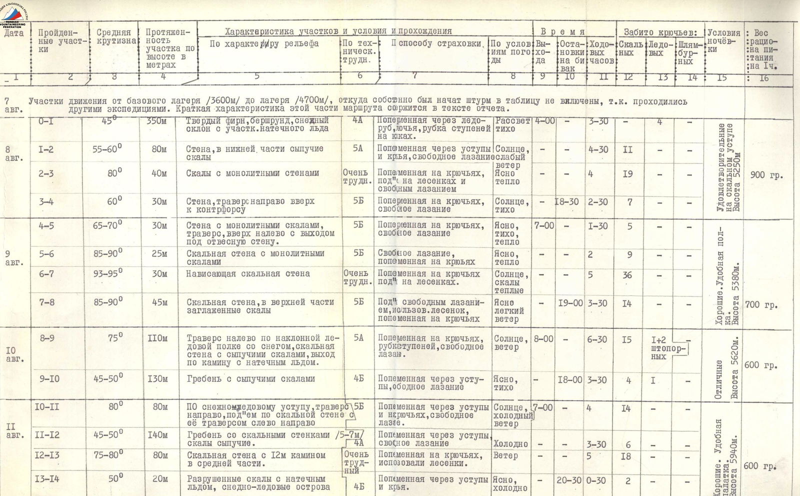
Photo 7. Character of rocks in the upper part of the section (R1–R2).
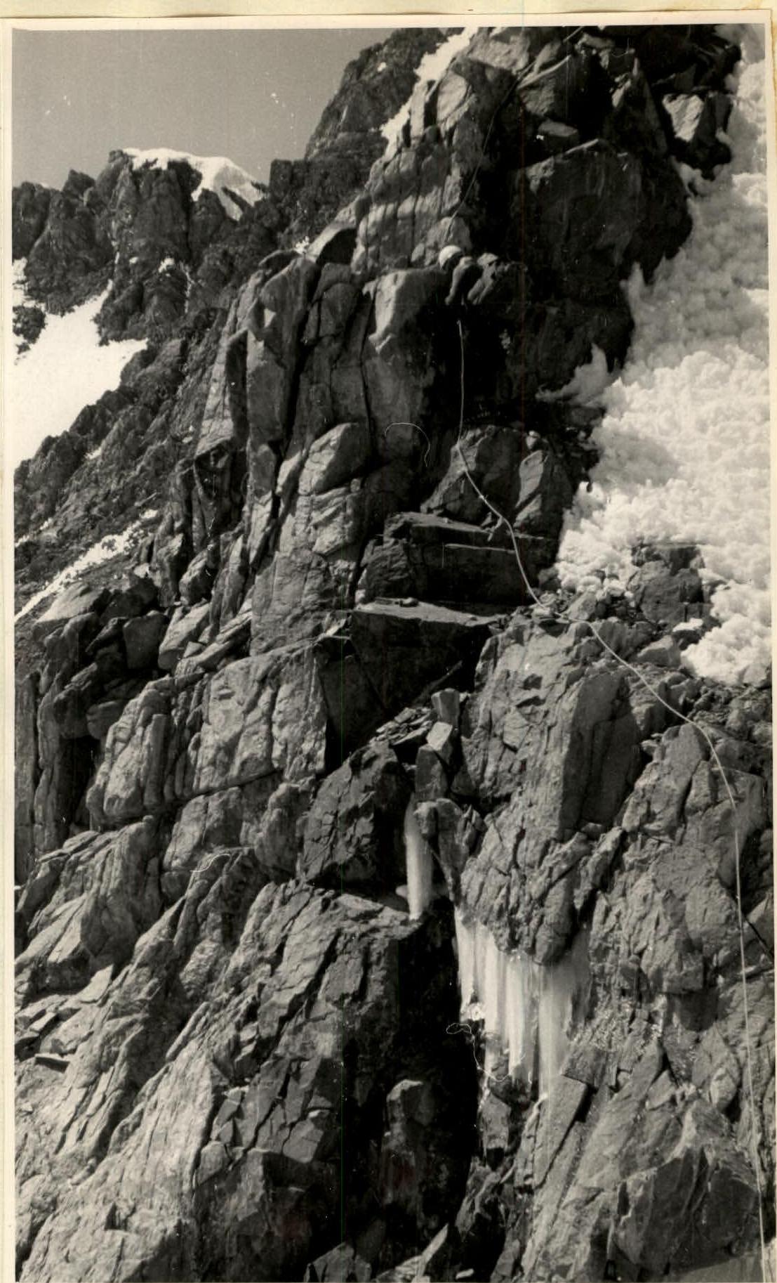
Photo 11. Overnight stay on August 9 on a ledge. Below — the plateau of the Upper cirque of the Markovsky glacier, visible is the Khitan, the Markovsky glacier covered with moraines, and further down the Pathor river gorge. The location of the base camp is marked with a cross.
Comments
Sign in to leave a comment