
Ascent Passport
- Ascent class — technical
- Ascent area — Pamir, Peter the First Ridge
- Peak, its height, ascent route — Peak 5244 m, via the left part of the western wall
- Estimated difficulty category — 5B cat. dif.
- Route characteristics:
- height difference — 550 m,
- average steepness — 70°,
- length of sections:
- cat. dif. — absent,
- cat. dif. — 15 m,
- cat. dif. — absent,
- cat. dif. — 405 m,
- cat. dif. — 308 m,
- cat. dif. — 91 m,
- total route length — 929 m.
- Pitons driven for insurance to create I.T.O.:
- rock — 107
- закладных — 3
- Number of climbing hours — 35 h
- Number of nights on the route: 4 nights. One night in camp I — lying, comfortable, in a tent. Three nights in camp II — lying, on snow, in a tent.
- Full name of the leader, participants, their sports qualification:
- Bodnik Vitaly Nikolaevich — MS, Kiev, leader
- Polevoy Vladimir Vladimirovich — CMS, Kiev, participant
- Barsukov Valery Albertovich — CMS, Kharkov, participant
- Sadovsky Anatoly Olgertovich — CMS, Kharkov, participant
- Tsakanyan Oleg Semenovich — CMS, Kharkov, participant
- Senior team coach — Kovtun Vasily Grigorievich
- Date of departure and return — June 29 – July 3, 1981
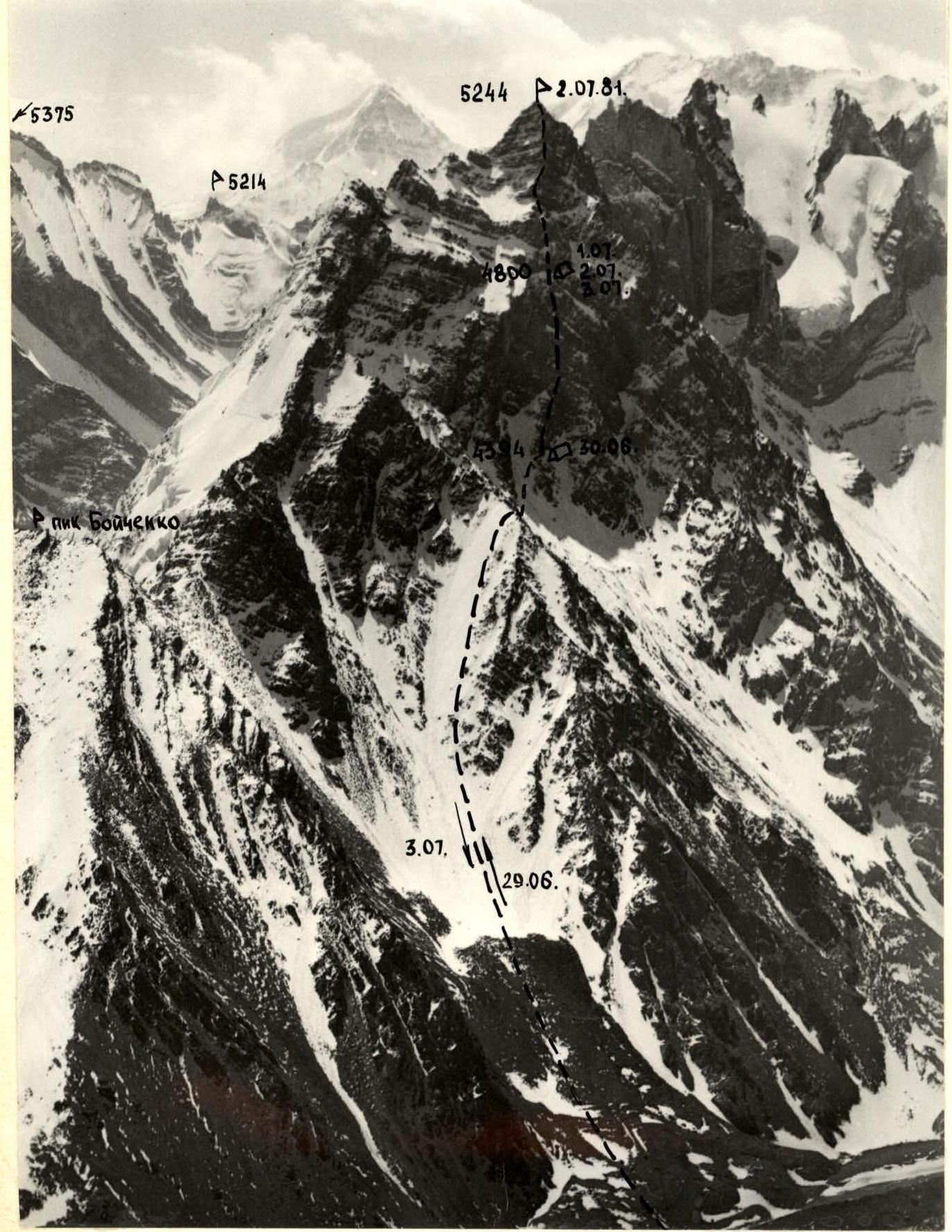
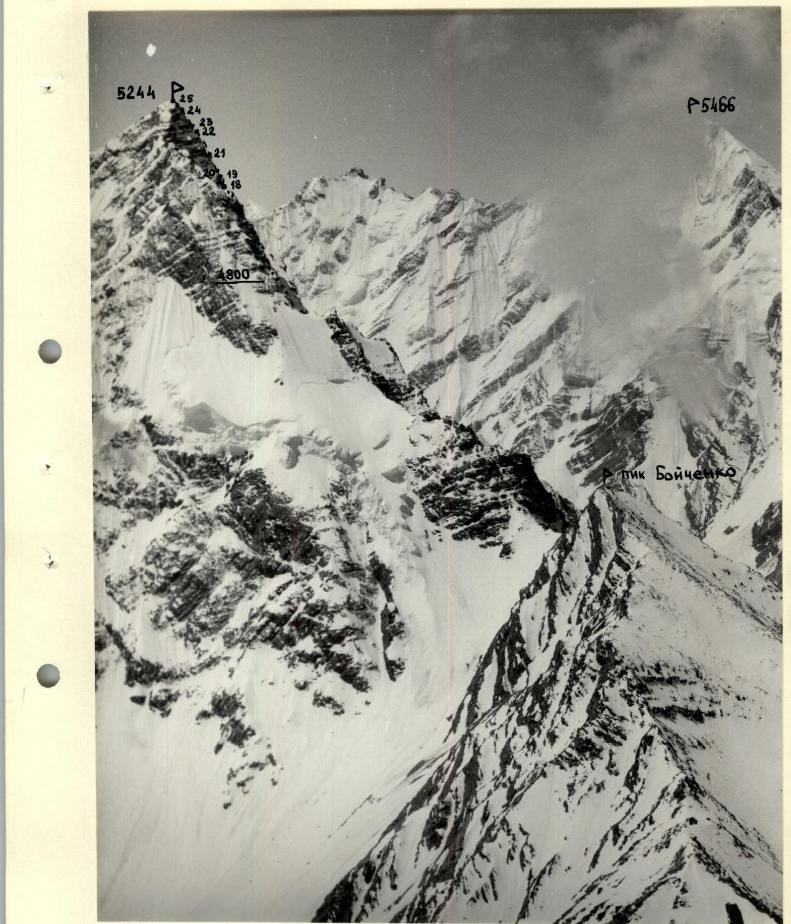
Upper part of the route profile
Area map

Organizational and tactical ascent plan
Pre-trip preparation included general physical and special training. Special training was conducted at a gathering in Crimea (Sudzak) from April 20 to May 1, 1981.
Preparation in the mountains. At the time of the ascent, all participants had training ascents of 3B–5A cat. dif. on peaks over 5200 m, in difficult weather conditions.
All this allowed us to conclude that the participants were prepared for this ascent (physically, technically, and mentally).
On June 25, 1981, a group consisting of Bodnik V. N. and Tsakanyan O. S. made a reconnaissance trip to the moraine of the Barolmas glacier under the western wall of Peak 5244 m. The group determined the optimal path to approach the route, which they observed for 5 hours. During this time, they:
- identified possible bivouac sites;
- assessed the feasibility of reaching them under various weather conditions;
- determined the necessary equipment and time required for different sections of the route;
- identified possible escape routes;
- identified key landmarks on the route;
- considered options for descending from the summit;
- assessed the possibility of radio communication with the base camp near Lake Maida-kul from various points on the route.
As a result of the observation, taking into account the unstable weather, the following ascent plan was adopted.
June 28 — departure from the base camp at 15:00, approach to the base of Peak 5244 m. Bivouac on a green meadow. The remaining daylight hours were dedicated to:
- observing the route;
- photographing the route;
- discussing the upcoming ascent.
June 29 — departure from the green meadow bivouac at 7:00. Approach to the western wall to the site of camp I (4400 m). Here, a bivouac was set up, and route processing began. For this purpose, 280 m of main rope were taken on the ascent.
June 30 — departure from camp I at 7:00. Passage of the processed section and arrival at the site of camp II (4800 m). Overnight stay in camp II.
July 1 — processing the route from camp II. Overnight stay in camp II.
July 2 — departure from camp II at 7:00. Passage of the processed section. Arrival at the summit around 16:00. Descent to camp II. Overnight stay in camp II.
Thus, the ascent was to be completed with four overnight stays in two camps, reducing the likelihood of uncomfortable nights and increasing the safety of the ascent.
Estimated number of climbing hours (to the summit) — 40 h.
In accordance with the nature of the route, it was planned to traverse key areas wearing galoshes. Two pairs of galoshes were taken on the route.
On the route, a new type of equipment was to be used:
- the first person in the rope team must wear a rupture-reinforced strap.
It was planned to make wide use of placement elements (sectors, hexes, prisms, etc.).
Nutrition on the route was to be sufficient to fully restore strength, i.e., adequate in both caloric content and quantity, ensured by the appropriate selection of products. The basis for this was the presence of only two camps on the route and preliminary route processing.
Table
Main characteristics of the ascent route to Peak 5244 m via the left part of the western wall
| Date | Section designation | Average steepness, ° | Length, m | Terrain character | Difficulty | Route condition | Weather conditions | Rock pitons | закладных pitons | Note |
|---|---|---|---|---|---|---|---|---|---|---|
| 29.06.1981 г. | R0–R1 | 60 | 40 | Walls, shelves | 4 | Clean rocks | Good weather | 4 | Route processing | |
| R1–R2 | 75 | 80 | Indistinct ridge | 5 | Destroyed rocks | Good weather | 10 | |||
| R2–R3 | 10 | 15 | Snow ridge | 2 | Loose snow | Good weather | ||||
| R3–R4 | 85 | 20 | Rock chute | 6 | Smoothed rocks | Good weather | 5 | П | ||
| R4–R5 | 10, trav. | 15 | Wall | 5 | Icy, snow-covered rocks | Good weather | 4 | |||
| R5–R6 | 70 | 8 | Slabs | 5 | Icy slabs | Good weather | 2 | |||
| R6–R7 | 110 | 6 | Cornice | 6 | Smooth slab with a crack | Good weather | 3 | У1 | ||
| R7–R8 | 85 | 40 | Wall | 5 | Destroyed rocks | Good weather | 6 | 3 | ||
| R8–R9 | 65 | 40 | Slabs | 5 | Snow-covered slabs | Good weather | 6 | |||
| R9–R10 | 90 | 20 | Wall | 6 | Snow-covered rocks | Good weather | 4 | У | ||
| Departure at 11:00. Stop at 18:00. Climbing hours 7 h 30 min. Descent and overnight stay in camp I. | ||||||||||
| 30.06.1981 г. | R10–R11 | 55 | 20 | Slabs | 5 | Icy and snow-covered slabs | Good weather | 4 | Work on the route | |
| R11–R12 | 55 | 10 | Slabs | 4 | Snow-covered slabs | Good weather | 2 | |||
| R12–R13 | 95 | 15 | Chimney | 6 | Chimney walls covered with ice | Good weather | 3 | |||
| R13–R14 | 75 | 20 | Rock-ice chute | 4 | Rocks, ice | Bad, strong wind, snow "groats" | 3 | |||
| R14–R15 | 60 | 120 | Rocks | 4 | Destroyed, snow-covered rocks | 10 | ||||
| Departure at 7:00. Stop at 19:30. Climbing hours 12 h 30 min. Overnight stay on snow in camp II. | ||||||||||
| 1.07.1981 г. | R15–R16 | 80 | 40 | Rocks | 5 | Snow-covered rocks | 7 | Route processing | ||
| R16–R17 | 75 | 40 | Rocks | 5 | Destroyed, snow-covered rocks | 5 | 2 | |||
| R17–R18 | 65 | 80 | Ridge, rocks | 4 | Icy rocks | 6 | ||||
| Departure at 9:00. Stop at 14:30. Climbing hours 5 h 30 min. Descent and overnight stay in camp II. | ||||||||||
| 2.07.1981 г. | R18–R19 | 100 | 7 | Cornice | 6 | Destroyed rocks | Satisfactory, fog | 3 | Work on the route | |
| R19–R20 | 32 | 13 | Slabs, walls | 4 | Snow-covered rocks | Satisfactory, fog | 2 | Work on the route | ||
| R20–R21 | 65 | 80 | Ridge | 4 | Icy rocks | 7 | ||||
| R21–R22 | 80 | 50 | Ridge | 5 | Snow-covered rocks | 4 | 5 | |||
| R22–R23 | 95 | 10 | Cornice | 6 | Destroyed rocks | 2 | 1У | |||
| R23–R24 | 65 | 100 | Ridge | 4 | Destroyed rocks | 5 | ||||
| R24–R25 | 85 | 25 | Wall | 5 | Rocks covered with ice | 5 | 3 | |||
| Departure at 8:00. At the summit at 17:30. Climbing hours 9 h 30 min. Descent to camp II at 20:30. Overnight stay in camp II. | ||||||||||
| 3.07.1981 г. | Departure at 7:00. Descent to the base camp at Lake Maida-kul at 15:00. |
Brief explanation of the table
Approach to the route. From the base camp on the shore of Lake Maida-kul, cross a grassy ridge descending from Peak Boychenko and separating the Maida and Borolmas valleys. Then, along the grassy slopes on the right orographic side, move up the Borolmas valley to the base of a wide couloir descending from the saddle between Peak Boychenko and Peak 5244 m. From the base camp, 2.5–3 hours. Here is a green meadow, a convenient place for an overnight stay. From here, 500 m up a wide scree couloir, sticking to its middle. Then, along a snow-ice slope with a steepness of 30–35°, 300 m, exit to the right-up to the couloir's neck. From here, 400 m along a snow slope with a steepness of 35° (in the upper part, 40°), exit to a rib. From here, traverse 200 m along a snow-ice slope, exit to rocky outcrops under the beginning of the route. Here is a convenient place for an overnight stay — camp I. From the overnight stay on the green meadow, 3–4 hours.
Route description.
Section R0–R1. From the overnight stay (camp I) straight up 40 m. Shelves alternating with 5–6-meter walls. Climbing 4 cat. dif. Steepness 60°. Piton insurance.
Section R1–R2. Further along an indistinct ridge 80 m. Climbing 5 cat. dif. Steepness 75°.
Section R2–R3. The ridge ends in a shoulder. Along a narrow snow ridge under the wall 15 m. 2nd cat. dif. Ropes through ledges.
Section R3–R4. Further along a rocky chute 20 m to the left-up. Climbing 6 cat. dif. Steepness 85°. Rocks are smooth. Use of I.T.O. Piton insurance.
Section R4–R5. Under the overhanging cornice, a difficult traverse to the left 15 m. Climbing 5 cat. dif. Rocks are icy, covered with snow.
Section R5–R6. Along steep icy slabs 8 m up under the cornice. Steepness 70°. Climbing 5 cat. dif.
Section R6–R7. The cornice is passed through a crack — 6 m. Steepness 110°. Climbing is difficult, 6 cat. dif. Use of закладных and ladders.
Section R7–R8. Along difficult rocks 40 m up. Steepness 85°. Climbing 5 cat. dif. Rocks lead to a narrow horizontal snow-covered shelf.
Section R8–R9. From the shelf, left-up along smoothed slabs covered with ice 40 m. Steepness 65°. Climbing 5 cat. dif. Exit under the second overhanging belt.
Section R9–R10. Further, bypassing a large red cornice on the right, exit to icy slabs — 20 m. Steepness 90°. Climbing 5–6 cat. dif. Use of ladders, закладных.
Section R10–R11. From here, left-up 20 m along icy, snow-covered slabs under a red overhanging wall. Climbing 5 cat. dif. Steepness 55°.
Section R11–R12. Further under the red wall straight up 10 m to the base of a wide overhanging ice slab filled with ice. Climbing 4 cat. dif. Steepness 55°.
Section R12–R13. Up a chimney 15 m. Climbing 6 cat. dif. Steepness 95°.
Section R13–R14. From here, left-up 20 m along the left side of a steep (75°) rock-ice chute. Climbing 4 cat. dif.
Section R14–R15. Further 120 m along destroyed rocks left-up towards a large red chip. Steepness 60°. Climbing 4 cat. dif.
Section R15–R16. From here, 40 m along steep, difficult rocks, bypassing the red chip on the left. Steepness 80°. Climbing 5 cat. dif. Exit under an overhanging rocky belt. Here, an overnight stay. Camp II.
Section R16–R17. From the overnight stay, left-up, bypassing the overhanging rocky belt 40 m. Difficult climbing 5 cat. dif. Steepness 75°.
Section R17–R18. Further along an indistinct ridge 80 m along icy rocks of medium difficulty, 4 cat. dif. Steepness 65°. Exit to a shoulder under the summit tower.
Section R18–R19. From the shoulder through a 20-meter overhanging, strongly destroyed cornice — 7 m, steepness 100°, and the remaining 13 m — 90°. Climbing is difficult, 6B cat. dif. Use of I.T.O.
Section R19–R20. From here, 15 m left-up — exit to a ridge leading to the summit. Snow-covered rocks. Climbing 4B cat. dif. Steepness 65°.
Section R20–R21. From here, 80 m along the ridge along icy rocks. Climbing 4B cat. dif. Steepness 65°.
Section R21–R22. Further, right-up along snow-covered rocks 50 m. Steepness 80°. Climbing 5B cat. dif. Exit under an overhanging crack.
Section R22–R23. Along the overhanging crack 10 m. Steepness 95°. Climbing 6 cat. dif. Passed on ladders with the help of закладных.
Section R23–R24. Further again along the ridge 100 m. Climbing 4 cat. dif. Rocks are destroyed. Exit under the summit bastion. Piton insurance and through ledges. Steepness 65°.
Section R24–R25. From here, 25 m along sheer rocks covered with ice, exit to the summit. Climbing 5 cat. dif. Steepness 85°.
Descent via the ascent route.