
Moscow City Council Burevestnik Sports Club
Ascent of Peak Suloev via the South Face, 5816 m (first ascent)
Leader: V.M. Nadbakh-Kiedessa Participants:
- I.V. Grebenshchikov
- V.K. Nevorotin
Moscow, 1969
The participants of this group are part of the team from the Central Council of the Burevestnik Sports Club, formed in the spring of 1969 to undertake high-altitude and technically challenging ascents.
In the summer of 1968, as part of the 2nd complex expedition of the Moscow City Council Burevestnik Sports Club, the participants of this group ascended Peak Lenin.
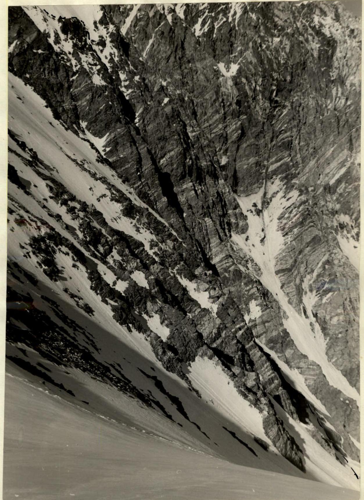
The goal of this expedition was to carry out transportation work on the Pamir Firn Plateau (50 kg) and to make memorial ascents to an unnamed peak, 5816 m, in the area of the Sortambek Glacier, and Peak E. Korzhenevskaya. Peak 5816 m is located in a lateral ridge branching off from Peak Krupskaya (6008 m) to the east, between the Turamys and Shapak glaciers (Fig. 1). Peak 5816 m is the dominant peak in this area (Photo 1), clearly visible from the Pamir Firn Plateau and the Sortambek Glacier, with a beautiful pyramidal shape. The idea of ascending this peak arose in the autumn of 1968, when it was decided to descend the body of V. Suloev, who had perished on Peak Communism. To this end, a joint expedition was organized by the Moscow City Council Burevestnik Sports Club and Zenit, led by Master of Sports Bozhukov.
On July 13, 1969, the advance group set up a base camp on a clearing near the Sortambek Glacier.
Throughout the autumn, winter, and spring, group members trained according to a general plan for participants in the high-altitude expedition under the guidance of Master of Sports A.G. Ovchinnikov. Particular attention was paid to rock climbing technique. Training sessions were held three times a week in Tsaritsyno, Podrezkovo, and the Sports Hall of the Bauman Moscow State Technical University.
The training program included:
- long cross-country runs up to 2 hours,
- cross-country skiing 30-40 km,
- climbing on towers and "palaces" in Tsaritsyno.
All group members underwent physical fitness checks before heading to the mountains, showing good results. Since 1966, the participants had experience in joint ascents.
Ascent of Peak V. Suloev
July 17
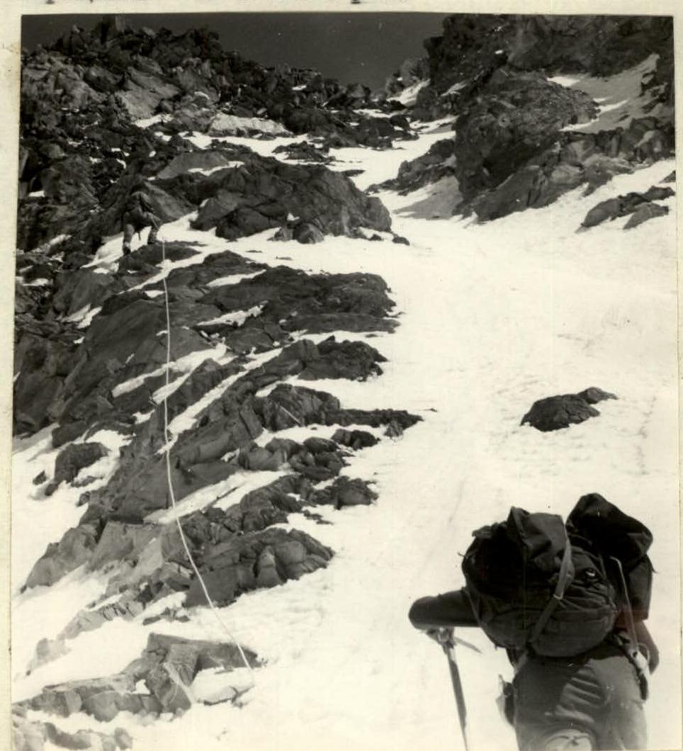
At 6:00 AM, the group consisting of V. Nadbakh-Kiedessa (leader), V. Bozhukov (coach), I. Grebenshchikov and V. Nevorotin (participants), and V. Zasetsky and L. Poroshin (observers) left the base camp, ascending up the left orographic side of the Turamys Glacier. The weather was good, with a clear sky. After 2.5 hours, the group reached the confluence of an unnamed glacier with the Turamys Glacier, where they built a large cairn. Turning right, they initially followed the left orographic moraine of the unnamed glacier and then moved to the median moraine, as the slopes of the ridge on the right and left were very prone to rockfall. After 1.5 hours, they stopped. A team consisting of V. Bozhukov, I. Grebenshchikov, and V. Nadbakh-Kiedessa went on a reconnaissance to the South Face to assess the route. The icefall was circumvented on the left. There was a platform for a tent at the foot of the wall. From here, they decided to start the assault on the wall. The route via the South Face is a narrow counterfort with an average steepness of 60-70°, leading directly to the summit. There was no snow on the route, indicating its great steepness. Rocks falling from above passed through the right and left couloirs of the wall. Objectively, the route did not appear to be prone to rockfall. Potential campsites were not visible. To view the route from the side, they decided to ascend to the saddle between peaks 5816 m and 5600 m.
July 18
At 7:00 AM, the group headed to the upper reaches of the Novator Glacier. Directly below the wall, the glacier turned sharply to the left (west). By 11:00 AM, they reached the saddle.
From here, the route was visible in profile in all its grandeur (Photos 3, 4). After such thorough reconnaissance, it was decided that it was most expedient to tackle the route as a single rope team due to the lack of visible campsites and the presence of highly fractured rock, which created a rockfall hazard when passing multiple rope teams.
It was decided not to bring:
- a tent,
- a primus stove.
Potential campsites were only considered above the wall section of the route, from where ascent and descent should not take much time.
The descent from the summit was planned via the western ridge, along which a group of first ascensionists had passed the day before, naming peak 5816 m as Peak V. Suloev, and rating this route as Category 4B difficulty.
The assault group consisted of V. Nadbakh-Kiedessa (leader), I. Grebenshchikov, and V. Nevorotin. V. Bozhukov, V. Zasetsky, and L. Poroshin remained as observers.
For communication between the assault group and observers, a VHF radio station weighing 700 g was taken.
For overnight stays, the assault group members were equipped with:
- down jackets with nylon outer layer,
- sleeping bags of the "elephant's foot" type,
- 40 mm thick foam rubber sheets.
Since there was no snow on the route, a primus stove was not taken. A flask with 1 liter of tea was brought.
July 19
The ascent began at 3:00 AM. It was cold. After receiving good wishes from the observers and tying in, the group set off upwards along the glacier to the left at 3:20 AM. They ascended a steep ice slope, местами up to 35°, via pre-cut steps, covering three rope lengths. Further to the right, bypassing a bergschrund, they followed firn towards two rock islands — four rope lengths. From here, two rope lengths on a steep snow slope led to the rocks of the counterfort. It was getting light. The rocks were heavily fractured with many "live" stones. They climbed very cautiously and carefully. On difficult sections, they had to remove their gloves. Along relatively gentle rocks — two rope lengths — they approached the base of the first steep ascent. They proceeded with alternate hook protection. The steepness increased to 50°. The rocks were of medium difficulty. They passed another two rope lengths. From this point, along a ledge to the right (4 m), then directly upwards along a sheer wall (8-10 m) with a poorly defined internal angle. The wall led to a narrow crevice — 50 cm — with an exit to the left onto a small platform with a projection convenient for arranging protection — one rope length. From here, they transitioned to the right part of the counterfort and again ascended,
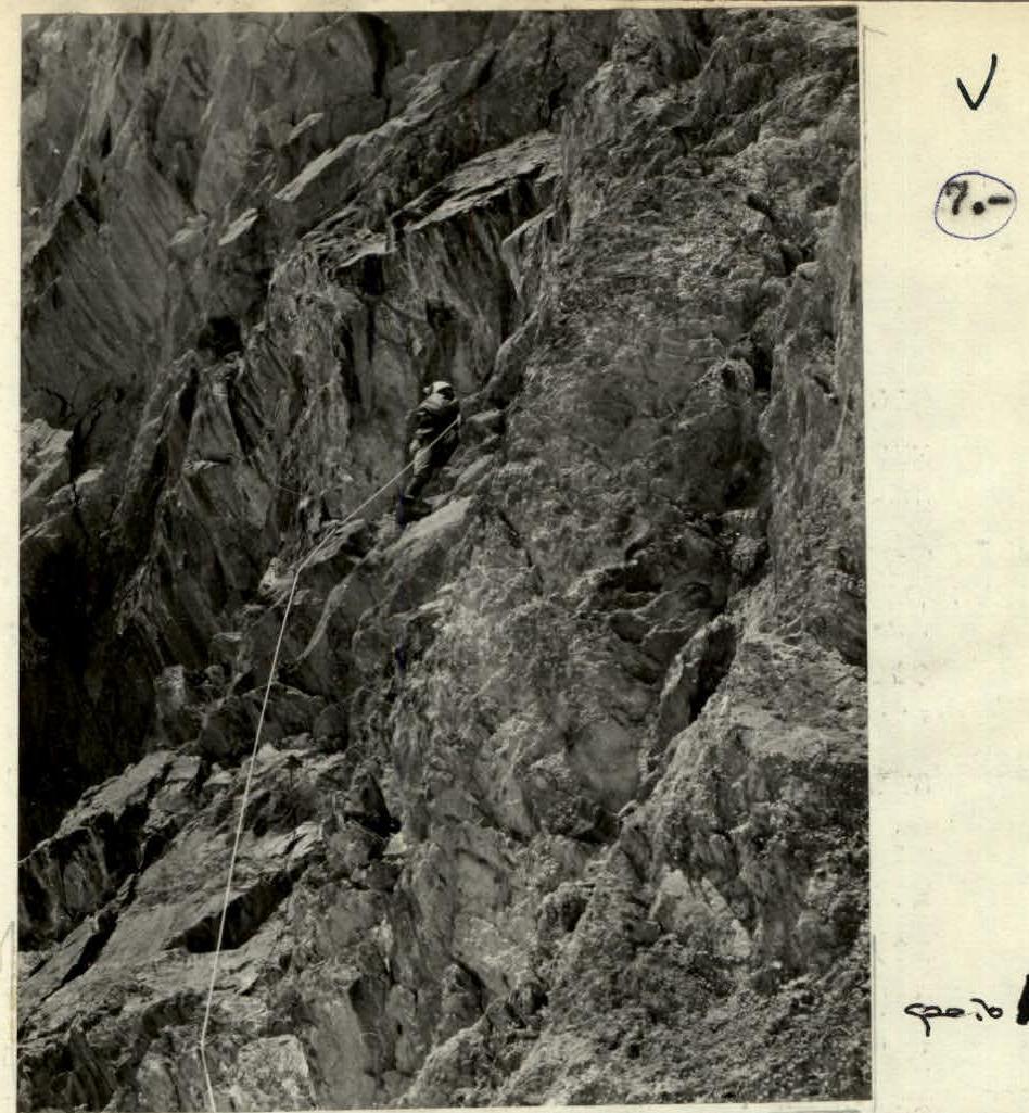
 (Photo 2)
using narrow ledges — two rope lengths. Here, there was a small platform where they all gathered together. 11:00 AM. First contact with observers. Observers reported that they had covered 2/5 of the rock part of the route, i.e., only a quarter of the entire route.
(Photo 2)
using narrow ledges — two rope lengths. Here, there was a small platform where they all gathered together. 11:00 AM. First contact with observers. Observers reported that they had covered 2/5 of the rock part of the route, i.e., only a quarter of the entire route.
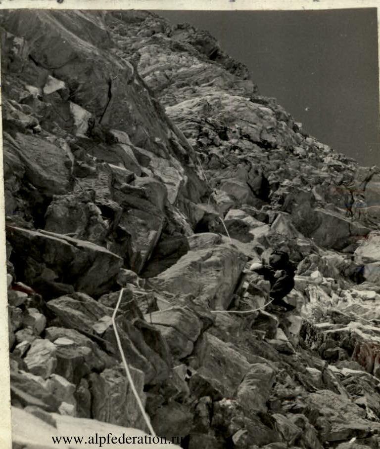
At this time, the wall was illuminated by the sun. It became warmer and more cheerful. The rocks heated up quickly, making climbing easier. From this point, the route became significantly steeper. Steepness up to 70°. There were no particular landmarks on the route. The path was very logical — along the clearly defined ridge of the counterfort. Igor Grebenshchikov led, with Vadim Nevorotin bringing up the rear. Most characteristic of this section were sheer walls 5-6 m high, overcome directly, and narrow ledges. Hook protection was used every 3-5 m, less often through projections, as there was almost no solid rock. They proceeded with short traverses, sometimes to the right, sometimes to the left, so that no one was directly below the person climbing. By 2:00 PM, they had covered seven rope lengths. This ascent ended on a small platform where a tent could be pitched. There was no water. From here began the key section concluding the wall. A traverse along a ledge to the right on heavily fractured rocks (15 m) was very difficult; there were no places to hammer in hooks, and no firm ledges. Further, 12 m along an internal angle of 90° steepness, transitioning into a narrow crevice with an overhanging plug at the end. The exit through the plug led to a ledge with "live" stones. A very difficult spot! From here, two rope lengths of steep rocks of medium difficulty led to a monolithic overhanging tower. To the right was a steep, rockfall-prone couloir, where rocks and ice continually fell from the pre-summit ridge. From under the tower, a horizontal traverse to the left along a narrow ledge under an overhanging wall (8 m) was difficult. Further, directly upwards — an overhanging wall (2 m), transitioning into an internal sheer angle of white marble — 20 m. Very complex! Handholds were very unreliable. This entire section was composed of large, loose marble blocks. The height was felt; breathing was difficult, especially on extended complex sections. Further directly upwards,
 (Photo 4)
A rope length of steep rocks led to relatively simple rock islands, alternating with snow and ice sections.
Two rope lengths of such rocks led to a "gendarme" crowning the wall section of the route. They named it "Petukh" (Rooster). They set up a control cairn. 4:00 PM. They were in contact with observers.
V. Bozhukov recommended stopping for the night, waiting for morning when the snow on the ice slope would have frozen.
After a discussion, they decided to continue upwards, organizing protection on the rock islands.
 (Photo 5)
From "Petukh":
- rappel 8 m onto snow;
- upwards along a snow slope through rock islands;
- two rope lengths.
From here, they exited to the right onto rocks and along rocks of medium difficulty — six rope lengths — to the summit. 7:00 PM. The summit. Peak V. Suloev was conquered via the South Face. The weather was good. Before them unfolded a majestic panorama of the ridges of the Academy of Sciences and Peter I. The giants of the Pamirs — Peak Communism and Peak Korzhenevskaya — adorned with their silent beauty this most magnificent mountaineering area.
At 8:00 PM, they began their descent along the western ridge. Fatigue was felt. They followed the tracks of the first ascensionists who had descended from here the day before. At 9:20 PM, they were greeted and congratulated by Vadim Bozhukov. They spent the night in a tent left below the route.
July 20
Return to camp.
 (Photo 6)
Conclusions and Recommendations
The route is combined. The height difference is 1100 m. Of these:
- 150 m — snow and ice slope;
- 600 m — wall;
- 350 m — pre-summit rock and ice slope.
About 80 rock and 6 ice screws were used. The average steepness is 60°. The route is rated Category 5B difficulty. The route is not prone to rockfall.
It is recommended for ascents by groups of no more than 3 people with good rock climbing technique. There are campsites both on the wall and higher up on the pre-summit slope.
Leader:
V. Nadbakh-Kiedessa
Participants:
I. Grebenshchikov
V. Nevorotin
Printed in 5 copies.
Comments
Sign in to leave a comment