PETRA I RIDGE — NORTH-WESTERN PAMIR
Report
ON TRAVERSE OF PIK GERoEV MALoY ZEMLI PEAK (5462 m) — PIK SEVERCEVA (5120 m) (FIRST ASCENT)
| № | Kovtun V.G. | MS | «Burevestnik» | — leader |
|---|---|---|---|---|
| 1. | Balinskiy A.P. | MS | «Burevestnik» | — participant |
| 2. | Bolizhevskiy V.K. | MS | «Burevestnik» | — participant |
| 3. | Yatsko V.S. | MS | «Burevestnik» | — participant |
| 4. | Polevoy G.V. | MS | «Spartak» | — participant |
| 5. | Fomin A.S. | MS | «Burevestnik» | — participant |
| 6. | Bozhko I.V. | CMS | «Burevestnik» | — participant |
| 7. | Derkach A.A. | CMS | «Burevestnik» | — participant |
| 8. | Dubinin V.N. | CMS | «Spartak» | — participant |
| 9. | Polevoy V.V. | CMS | «Spartak» | — participant |
| 10. | Zhuravlev B.F. | I | «Spartak» | — participant |
| 11. | Tarasenko A.I. | I | «Zenit» | — participant |
June 30 – July 6, 1978
 www.alpfederation.ru↗
Brief geographical and sports characteristic of the region
Petra I Ridge on the North-Western Pamir — the location of the expedition of the Ukrainian trade unions and Central Committee of LKSMU. Petra I Ridge stretches almost exactly in the latitudinal direction for 160 km, starting on the west with low grassy mountains and ending on the east with the highest peak of our country — Peak Kommunizma. The area where the expedition worked is very interesting in terms of sports. Dozens of peaks above 5000 m are still unconquered. As a rule, all peaks are difficult to access, and there are no easy paths to them. Routes along the northern walls are particularly complex.
The history of the research of Petra I Ridge takes us back to the distant past. Back in the last century, the great Russian researcher V. F. Oshanin first described and explored the powerful mountain chain and gave it the name — Petra I Ridge. This was in 1876. And in 1899, the Russian researcher V. I. Linsky surveyed the ridge in its upper reaches, where he discovered and described the largest glaciers flowing from its slopes. After the Great October Socialist Revolution, several expeditions worked in the area of Petra I Ridge, which more thoroughly explored the mountain ranges and glaciers. However, in sports terms, Petra I Ridge was first explored in 1947. The expedition, which included many of the strongest climbers of that time, overcame enormous difficulties, penetrated the upper reaches of the ridge, where:
- outlined the paths for ascending to the peaks;
- made the first ascent of a peak, which was given the name "Peak XXX Anniversary of the Soviet State".
This was the first peak in Petra I Ridge conquered by climbers. The ascent was led by the outstanding Soviet climber — Honored Master of Sports of the USSR E. M. Abalakov.
Petra I Ridge is the watershed of the Obikhingou and Muksu valleys. Rivers flowing from the slopes in this part of the ridge are not very full-flowing and are practically forded. Snowy, rocky spurs of the ridges, dividing the valleys of the glaciers, gradually turn into grassy hills, which separate the river valleys.
Glaciers in the lower part are heavily crevassed, in many places covered with surface moraine. The rocky rocks are of volcanic origin, fragile, brittle, and in some places clayey. In the upper part, the glaciers are heavily snowed, while many peaks are covered with pure ice. Peaks at altitudes of more than 5000 m also have fragile rocks, requiring great care when working on them.
On many peaks and ridges, there are overhanging cornices. In some places, the cornices are significantly protruding. The area has quite significant glaciation.
The weather at the end of June — beginning of July in this region is stable. Sometimes by the end of the day, clouds appear, and snow grains may fall at the top. However, there are no prolonged bad weather periods, although the region is generally cold. Even in the base camp at an altitude of 3300 m, the temperature sometimes dropped below 0° at night.
The nearest settlement from the base camp is Dzhirgatal. It takes 15 minutes to fly there from the base camp by helicopter. During the ascent to peak 5462, starting from the ice cap, you can see Dzhirgatal. Accordingly, from Dzhirgatal, you can see a beautiful ice pyramid — this is the upper part of the peak 5462 m.
Organizational and tactical plan for the ascent
The combined team of trade unions of the Ukrainian SSR began the cycle of preparation for making ascents in the unexplored mountaineering region of Petra I Ridge back in 1977, when the Mountaineering Federation of the Ukrainian SSR reviewed and approved the plans for the expedition's work and preparation, the composition of the participants, the training council, and the support staff. The plans and objectives of the expedition were approved and endorsed by the Central Committee of LKSMU and Ukrsporf.
All materials related to the proposed area of ascents were developed. Literature on the geological structure of Petra I Ridge, its nature, glaciation, and possible approaches and landings to the peaks was studied.
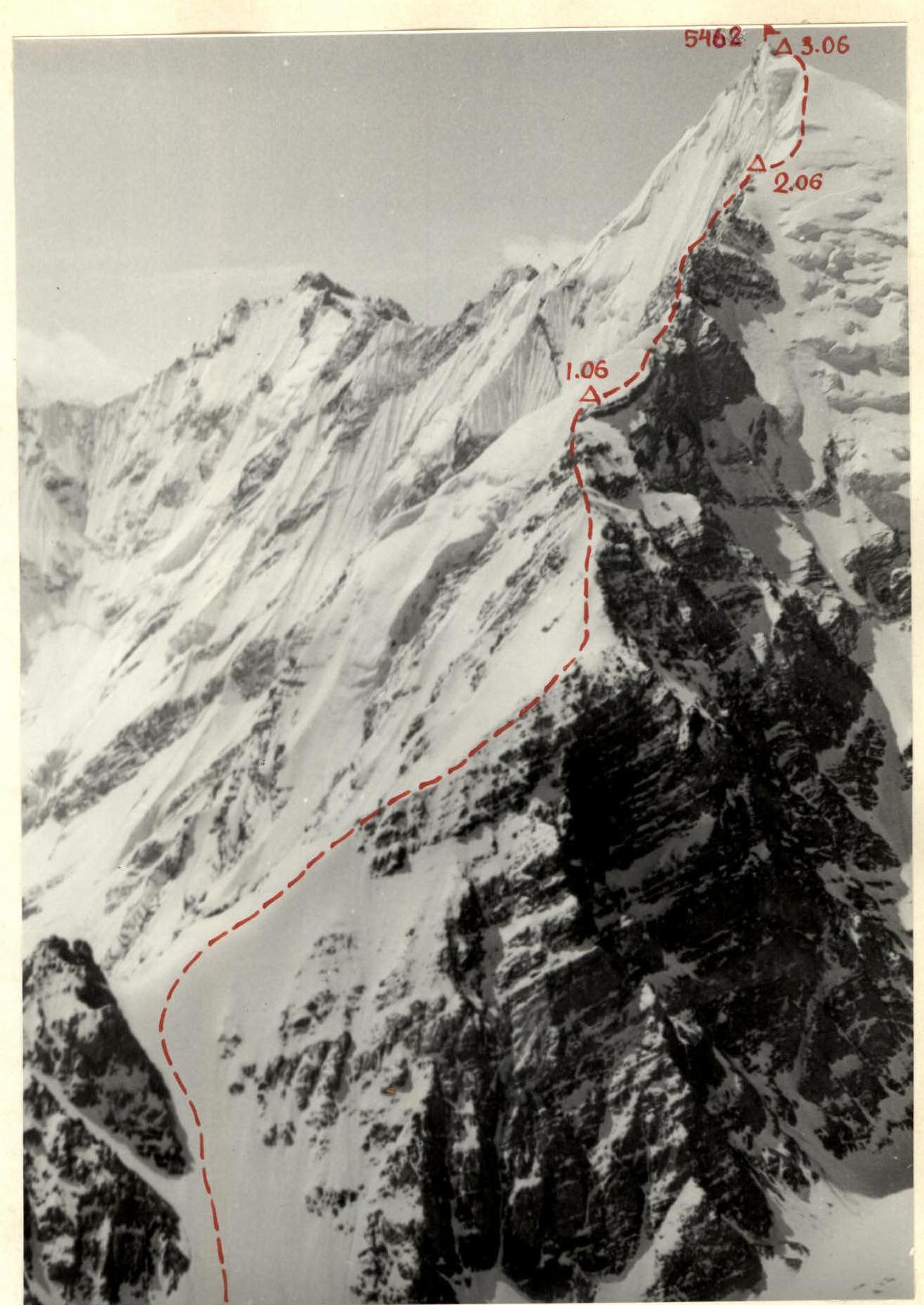 Peak 5462 (Peak Heroes of the Malaya Zemlya) from the north.
Preparation for departure to the mountains: all participants were directly preparing for the ascent during the autumn-winter period of 1977–1978. All participants of the expedition trained in their sections at least 4 times a week, and starting from February, they held outings on rocky massifs on Saturdays and Sundays, where they practiced the technique of passing rocky areas.
During the preparatory period, a lot of high-quality equipment necessary for ascents was tested and prepared. Screw titanium pitons were made for passing ice sections, and twelve-tooth ice crampons were made and tested. For rocky areas, a sufficient number of titanium rock pitons, carabiners, and sling pitons were prepared.
During the preparatory period, the necessary bivouac and household equipment was prepared and packed for shipment — stationary tents, gas stoves and cylinders, fuel cans, food, etc.
Preparation in the mountains: all participants of the expedition arrived in Dushanbe on June 13, 1978. The participants were warmly welcomed at the Central Committee of LKSM of Tajikistan, where they were given a warm welcome and effective assistance in solving various issues (transport, logistics, etc.).
On June 16 and 17, cars with food and equipment were sent to Dzhirgatal. The participants of the expedition arrived in Dzhirgatal by plane.
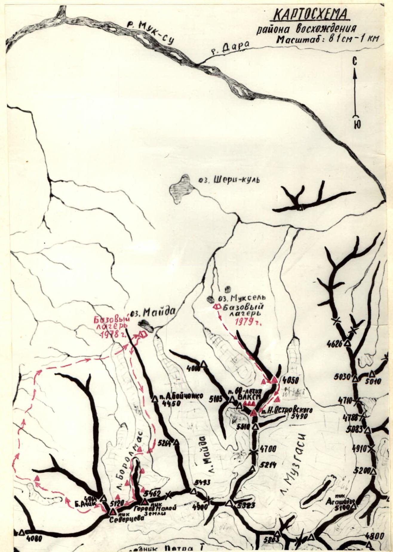
During June 18 and 19, all participants of the expedition were transported to the base camp near Lake Maida at an altitude of 3300 m above sea level. The location for the base camp was chosen during reconnaissance flights and overflights of the objects of the proposed ascents. The Dushanbe aviation unit's worker, pilot extraordinaire Yu. N. Zhuravlev, provided great assistance to our expedition in this matter.
In the base camp, the expedition equipped a kitchen, warehouses for food and equipment, living tents, and installed a radio station for communication with Dzhirgatal airport.
During the following days (4 days), a cycle of ice-snow and rock training, acclimatization, and reconnaissance outings were conducted. The preparatory cycle was completed with a first ascent to peak 4450 m. The ascent was approximately rated by the group as 2B category of difficulty. The first ascenders unanimously decided to petition the relevant organizations to name peak 4450 m after A. Boychenko — the first secretary of the Central Committee of LKSMU.
After completing the training cycle, it was decided to proceed directly to fulfilling the main objectives of the expedition — making first ascents to peaks 5462 m and 5105 m. If these objectives were successfully achieved, it was decided to petition the Council of Ministers of the Tajik SSR to name these peaks — Peak Heroes of Malaya Zemlya and Peak 60th Anniversary of Komsomol.
Over the course of 3 days, backloads were made, a storm camp was set up, and observations were made of the planned route to peak 5462 m with a further traverse to Peak Severtsev.
The observations showed that the planned route represented a complex combined route with a large altitude difference, ice-snow sections of great length, destroyed and sometimes brittle rocks. Despite the significant destruction, the rocks are complex, and the wall sections are steep, dangerous, and have significant length. A tactical plan for the first ascent was drawn up, and food and necessary equipment were selected.
On June 30, the group set out to traverse peaks 5462 – Peak Severtsev.
Ascent description
June 30
The group left the base camp at 14:00. We cross a green hill, which is the watershed of two gorges, and descend into the Buralmas gorge. Then, crossing the valley, we move up along the right bank of the Buralmas glacier. The path initially passes through grassy slopes, then through scree. At the point where it is most convenient to descend from the glacier to the moraine, we exit onto the Buralmas glacier and, avoiding crevasses, cross the glacier in the direction of the ridge of peak 5462. After crossing the glacier and climbing onto its left-bank moraine, we find a convenient spot for an overnight stay.
- We set up tents.
- It takes 5 hours of walking from the base camp to the overnight stay.
- We plan to depart at 6:00.
- The bivouac altitude is 3800 m.
July 1
The duty team rises at 4:00. At 6:00, the group is ready to depart. We overcome a small scree slope and exit onto snowfields. We ascend straight up through the snow in the direction of a gap in the ridge. The snow slope is not very steep in the lower part — about 35°. The middle part of the slope has a steepness of about 45°. In the upper part, the slope is icy, with a steepness of about 50°. We pass the entire section to the saddle on crampons. In the lower part, we use an ice axe for belay. On the ice, we have to screw in pitons and hang fixed ropes. Further, the path goes along the ridge to the right and upwards. These are steep, destroyed, snow-covered rocks. We move very cautiously, as there are many "live" stones. Belay on the ridge is through outcrops and sometimes through pitons. We traverse along the ridge for about 350 m and exit onto a small platform. It's a convenient spot for a rest. Here, the ridge makes a sharp turn to the left and becomes much steeper than before.
Immediately from the platform, there is a steep ice ascent. We pass it on crampons and exit onto steep, heavily destroyed rocks. At this point, as well as further along the route, the ridge is very narrow, with steep walls on both sides. The structure of the rocks forces us to move very cautiously — there are many live stones and rocks of unreliable, tile-like structure. We overcome two steep walls, 80 m high, with fixed rope belay. The first person climbs the walls in crampons. After overcoming the walls, we exit onto a convenient ledge, where we set up a bivouac. Time: 18:00, altitude: 4800 m. We believe that we worked very well today. At 21:00 — lights out.
July 2
The morning is very cold. A strong north wind is blowing. We depart at 7:00. We have to climb a snow slope with a steepness of 50°. We pass it on crampons. The snow is dense and formed. Crampons hold well. Belay is through an ice axe. We exit onto a narrow, steep, and heavily destroyed rocky ridge, traverse along the ridge with alternating belay.
In some places, the belay is through pitons. Further, there is a descent into a gap — 40 m to a narrow snow saddle under the main wall. To our surprise, the wall is quite solid. The steepness is about 90°. The wall is 120 m long. The first person climbs the wall in crampons. Here, we have to organize a rope pull for backpacks. The first 40 m of the wall are climbed along the left side, bypassing a protruding glazed rock along a small internal angle. The internal angle leads to a small ledge, where we set up an intermediate belay point and pull the backpacks.
The next 40 m are climbed along a smooth, sheer wall. Handholds are very small and not always reliable. The wall leads to a rocky outcrop, where we can set up a reception point for participants and pull the backpacks. Further, the path goes to the left and upwards, bypassing cornices along a smooth wall. The wall ends with an overhang, which we overcome using ladders.
At the top of the wall, there is a small cornice. The wall leads to a heavily destroyed ridge. The rock structure is like compacted moraine. We move extremely cautiously. We traverse along the ridge for two rope lengths. The ridge has gendarmes and drops between them. Everywhere, there are fixed ropes, as despite the fact that the ridge is heavily destroyed, it drops off on both sides with huge walls. It's sometimes surprising how everything stands and holds.
The ridge leads to a steep, destroyed wall:
- The first rope length — steep, heavily destroyed rocks, very fragile and unreliable. Belay is organized through ice pitons and wooden wedges.
- Further, the wall becomes stronger, but is still heavily destroyed.
- We try to climb the entire wall along the junction of the two huge walls of the massif — the northern and northwestern ones. The walls drop off onto the glaciers with enormous sheer faces.
- We traverse along it for three rope lengths and exit to a snow ascent.
We climb the snow ascent and exit under a sheer wall:
- The wall is 20 m high.
- Type — "ram's foreheads".
- Rocks are steep and glazed.
- Handholds are small and unreliable.
We overcome it and exit onto a very convenient platform, where we set up a bivouac. Time — 18:00. Altitude — 5080 m.
July 3
Directly from the bivouac, a steep snow "sickle" leads upwards, leading to the icy slopes of the peak. We depart at 7:00. It's very cold. A strong north wind is blowing. We traverse more than two rope lengths along the sharp snow "sickle" and exit onto steep icy slopes.
Even from below, during observations of the route, we saw that passing this section would require a lot of work. There are transverse crevasses; the upper wall is much higher than the lower one. However, a sufficient number of pitons allows us to continue climbing upwards. Everyone is working on crampons. In some places, we have to cut steps.
At 14:00, we exit onto the subpeak. From here, there is a stunning view of the entire Petra I Ridge. In the distance, you can see our grandiose seven-thousanders — Peak Kommunizma and Peak E. Korzhenevskaya, as well as many other still unconquered peaks. From this point, a steep, heavily destroyed ridge leads to the peak. To the north, the ridge has huge overhanging cornices.
We reach the summit at 16:00. A traditional note and banners of the "Spartak" and "Burevestnik" societies are placed in a cairn.
We begin our descent to the subpeak along the ascent route. Here is a convenient spot for an overnight stay, and from here, a ridge leads towards the saddle between Peak Severtsev and the just-conquered peak — Peak 5462 m.
Unanimously, we decide to appeal to the Presidium of the Supreme Soviet of the Tajik SSR with a proposal to name peak 5462 m — Peak Heroes of Malaya Zemlya.
At 18:00, we set up a bivouac on the subpeak. The night is very cold. The altitude is felt. The strong north wind does not subside.
July 4
We depart at 7:00. A snow-rock ridge leads to the saddle between Peak 5462 m and Peak Severtsev. The ridge is destroyed and steep. The descent is everywhere sporty. The last person descends either sportily with a pulled rope or with intermediate lower belay. The ridge between the two peaks does not have significant drops. There are three gendarmes.
- The first one is overcome head-on. These are not very complex, destroyed rocks.
- The second gendarme is a steep ice ascent, 40 m high. The first person climbs it on front points and sometimes cuts steps. The descent from the gendarme is sporty, down an icy slope.
- The third gendarme is a huge rocky massif on the ridge. We overcome it by bypassing it on the left, along steep rocky slopes. Belay is through outcrops and pitons.
Behind the gendarme, there is a convenient spot for an overnight stay. The altitude is 4900 m. Immediately behind the gendarme, the ascent to Peak Severtsev begins. But that's for tomorrow. Here, we set up a bivouac.
July 5
We depart at 6:30. Immediately from the overnight stay, the ascent begins along destroyed rocks. The rocks are red, like the entire massif of Peak Severtsev. The wall of the peak, dropping off to the north, looks grandiose. However, it is destroyed, and continuous rockfall occurs along it. We climb a steep wall, about 150 m long, and exit onto the subpeak. Despite the significant steepness, the wall has a rich relief and many cracks. The first person climbs in crampons and is very attentive, as there are whole blocks of "live" stones. From the subpeak of Peak Severtsev, we ascend along a fairly steep rocky ridge to the summit. From the summit of peak 5120 m, the views are no less beautiful than from the summit of peak 5462 m. The recently conquered peak looks particularly beautiful. The beautiful forms, the great length, and steepness of the route traversed evoke a sense of sporting satisfaction.
The descent to the saddle between Peak Severtsev and Bolshaya Achik (4900 m) is initially along a rocky ridge, then along an icy slope. From the saddle, we move down an icy slope into the gorge. The descent is always sporty and on crampons, as the icy slope is quite steep (up to 65°).
At 18:30, we exit onto a good grassy platform, where we decide to spend the night. We congratulate each other on completing the long ascent.
July 6
We depart from the bivouac at 7:00 and descend into the river valley. The whole day, we walk along the grassy slopes of the river. At 17:00, the group arrives in full at the base camp.
Conclusion on the route
The route traversed by the group represents a traverse of two peaks — Peak 5462 m — Peak Severtsev (5120 m). Both peaks were climbed for the first time, and they are of great sporting interest.
The presence of many complex ice-snow sections, steep walls, complex, and extended ridge sections makes this combined route very interesting and saturated in sports terms.
We believe that in terms of its length, the presence of sections of the highest category of difficulty, and the steepness of complex sections, the route deserves to be classified as 5B category of difficulty.
This is also the opinion of all participants in the ascent.
Expedition leader G. Polevoy
Ascent leader V. Kovtun
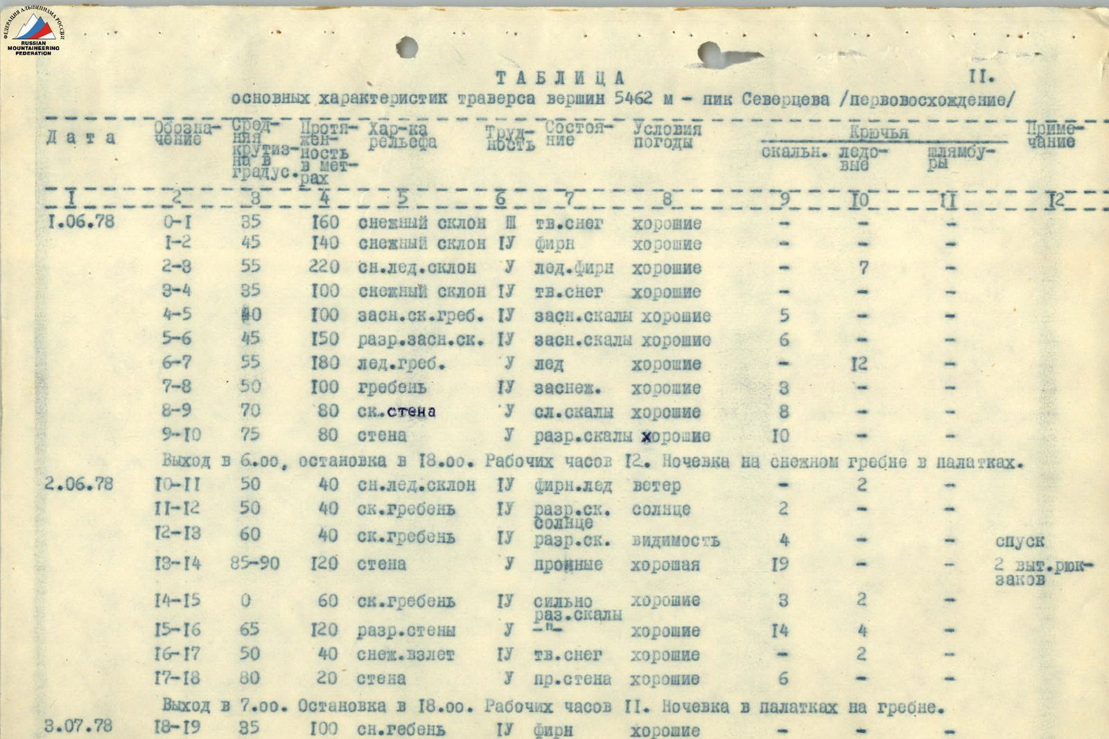
Table
Main characteristics of the traverse of peaks 5462 m – Peak Severtsev (first ascent)
| Date | Designation | Average steepness in degrees | Length in meters | Relief characteristic | Difficulty | State | Weather conditions | Rock pitons | Ice pitons | Drill anchors | Note |
|---|---|---|---|---|---|---|---|---|---|---|---|
| 1.07.1978 | R0–R1 | 35 | 160 | snow slope | 3 | hard snow | good | - | - | - | - |
| R1–R2 | 45 | 140 | snow slope | 4 | firm | good | - | - | - | - | |
| R2–R3 | 55 | 220 | snow-ice slope | 5 | ice-firm | good | - | 7 | - | - | |
| R3–R4 | 35 | 100 | snow slope | 4 | hard snow | good | - | - | - | - | |
| R4–R5 | 40 | 100 | snow-covered rocky ridge | 4 | snow-covered rocks | good | 5 | - | - | - | |
| R5–R6 | 45 | 150 | destroyed snow-covered rocks | 4 | snow-covered rocks | good | 6 | - | - | - | |
| R6–R7 | 55 | 180 | icy ridge | 5 | ice | good | - | 12 | - | - | |
| R7–R8 | 50 | 100 | ridge | 4 | snow-covered | good | 3 | - | - | - | |
| R8–R9 | 70 | 80 | rocky wall | 5 | complex rocks | good | 8 | - | - | - | |
| R9–R10 | 75 | 80 | wall | 5 | destroyed rocks | good | 10 | - | - | - | |
| Departure at 6:00, stop at 18:00. Working hours 12. Overnight stay on a snowy ridge in tents. | |||||||||||
| 2.07.1978 | R10–R11 | 50 | 40 | snow-ice slope | 4 | firm-ice | wind | - | 2 | - | - |
| R11–R12 | 50 | 40 | rocky ridge | 4 | destroyed rocks | sun | - | 2 | - | - | |
| R12–R13 | 60 | 40 | rocky ridge | 4 | destroyed rocks | visibility | - | 4 | - | descent | |
| R13–R14 | 85–90 | 120 | wall | 5 | solid | good | 19 | - | - | 2 pulls of backpacks | |
| R14–R15 | 0 | 60 | rocky ridge | 4 | heavily destroyed rocks | good | 3 | 2 | - | - | |
| R15–R16 | 65 | 120 | destroyed walls | 5 | - | good | 14 | 4 | - | - | |
| R16–R17 | 50 | 40 | snowy ascent | 4 | hard snow | good | - | 2 | - | - | |
| R17–R18 | 80 | 20 | wall | 5 | solid wall | good | 6 | - | - | - | |
| Departure at 7:00, stop at 18:00. Working hours 11. Overnight stay on a ridge in tents. | |||||||||||
| 3.07.1978 | R18–R19 | 35 | 100 | snowy ridge | 4 | firm | good | - | - | - | - |
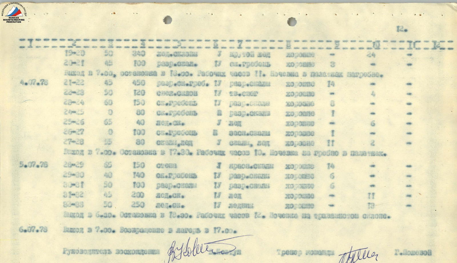 | |||||||||||
| R19–R20 | 50 | 340 | icy slope | 5 | steep ice | good | - | - | - | 24 | |
| R20–R21 | 45 | 100 | destroyed rocks | 4 | rocky ridge | good | 3 | - | - | 8 | |
| Departure at 7:00, stop at 18:00. Working hours 11. Overnight stay on a ridge in tents. | |||||||||||
| 4.07.1978 | R21–R22 | 45 | 450 | destroyed snowy ridge | 4 | destroyed rocks | good | 14 | - | - | - |
| R22–R23 | 50 | 120 | snowy slope | 4 | hard snow | good | - | 4 | - | - | |
| R23–R24 | 60 | 150 | rocky ridge | 4 | destroyed rocks | good | 8 | - | - | - | |
| R24–R25 | 0 | 80 | rocky ridge | 4 | destroyed rocks | good | 1 | - | - | - | |
| R25–R26 | 65 | 40 | icy | 5 | ice | good | 6 | - | - | - | |
| R26–R27 | 0 | 100 | rocky ridge | 4 | snow-covered rocks | good | 1 | - | - | - | |
| R27–R28 | 55 | 80 | rocks, ice | 5 | complex ice | good | 11 | 2 | - | - | |
| Departure at 7:00, stop at 17:30. Working hours 10. Overnight stay on a ridge in tents. | |||||||||||
| 5.07.1978 | R28–R29 | 65 | 150 | wall | 5 | red rocks | good | 14 | - | - | - |
| R29–R30 | 40 | 140 | rocky ridge | 4 | destroyed rocks | good | 6 | - | - | - | |
| R30–R31 | 50 | 100 | destroyed rocks | 4 | destroyed rocks | good | 6 | - | - | - | |
| R31–R32 | 45 | 250 | icy | 4 | ice | good | - | 11 | - | - | |
| R32–R33 | 50 | 250 | glacier | 4 | glacier | good | - | 1 | - | - | |
| Departure at 6:30, stop at 16:30. Working hours 10. Overnight stay on a grassy slope. |
July 6, 1978. Departure at 7:00. Return to camp at 17:00.
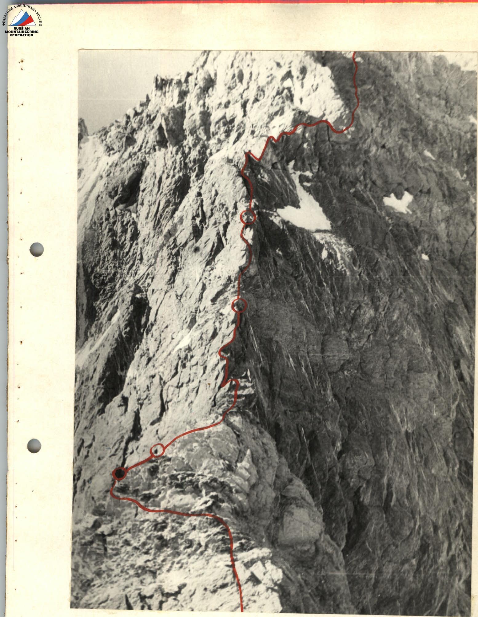
R13–R14 section. Steep wall of the Northern ridge.

ROUTE OF ASCENT TO PIK SEVERCEVA (5120 m) FROM THE SADDLE.