
Report
on the traverse of the peaks of the northwestern spur of the Petra I ridge: Zapadny Oshanina (6305) — Centralny Oshanina (6390) — Vostochny Oshanina (6310) — 30 let Sovetskogo Gosudarstva (6447) — Moskva (6785) with ascent to Zapadny Oshanina peak from the Shini-Bini saddle via the northern ridge (first ascent)
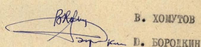
Team of Moscow City Council "Burevestnik" Sports Society Team captain: Candidate Master of Sports V. Khomutov. Team coach: Master of Sports Yu. Borodkin.
Route Characteristics
Peaks included in the traverse:
- Zapadny Oshanina peak — 6305 m
- Centralny Oshanina peak — 6390 m
- Vostochny Oshanina peak — 6310 m
- 30 let Sovetskogo Gosudarstva peak — 6447 m
- Moskva peak — 6785 m
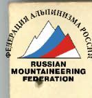
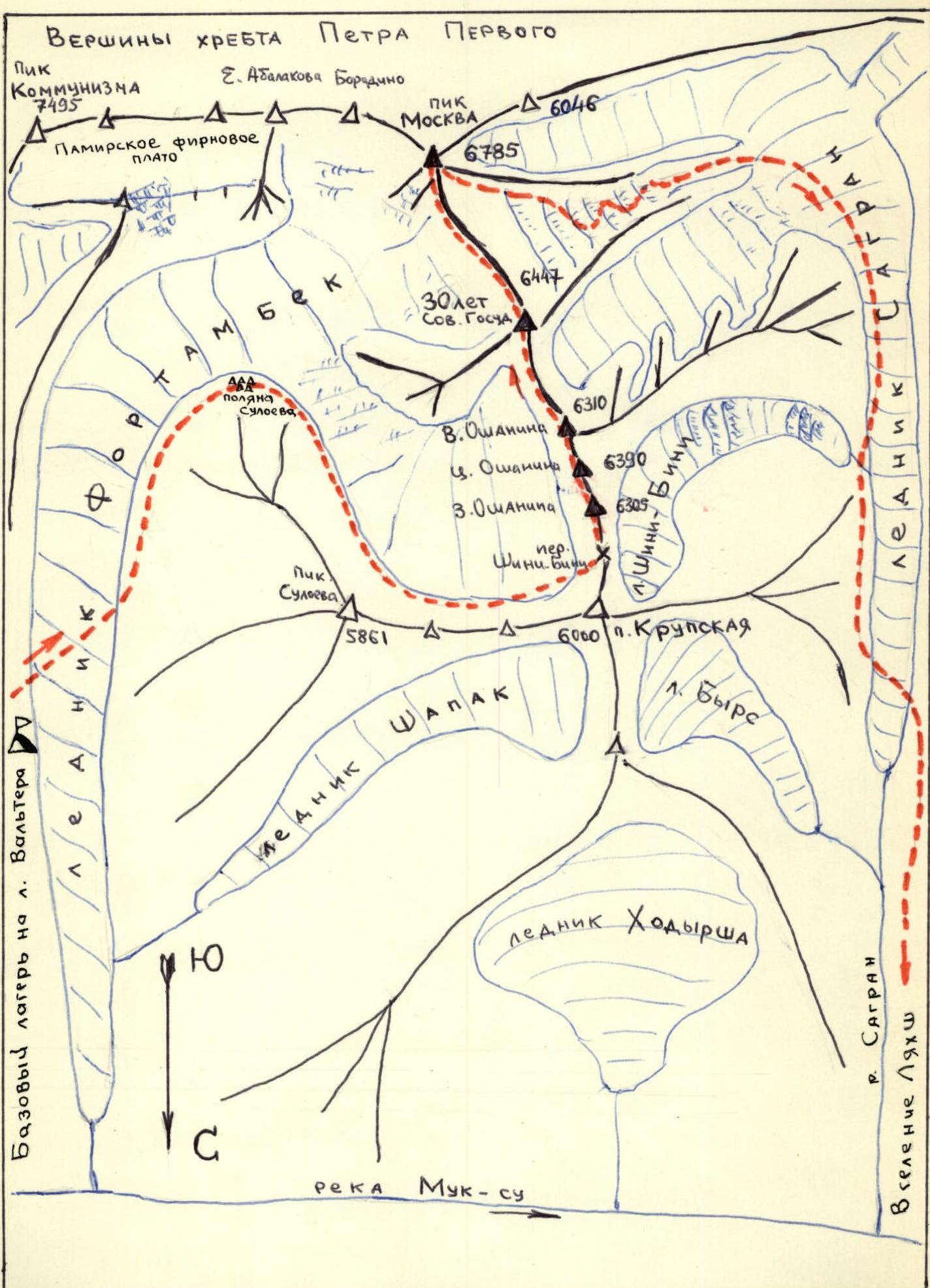
All five peaks of the traverse are located in the northwestern spur of the Petra I ridge. The spur branches off from Moskva peak and represents a two-kilometer barrier between the upper reaches of the Fortambek and Sagrant glaciers. The ridge connecting the peaks is characterized by large altitude differences of up to 800 m (see photo 9) and is located at an altitude of over 6000 m (photo 1). The length of the ridge is 100 km.
Altitude gain during ascents
| № | Route sections | Altitude gain (meters) |
|---|---|---|
| 1 | Upper Fortambek glacier (4600) — Shini-Bini saddle (5100) | 500 |
| 2 | Shini-Bini saddle (5100) — Zapadny Oshanina peak (6305) | 1205 |
| 3 | Saddle between Zapadny and Centralny Oshanina (6000) — Centralny Oshanina peak (6390) | 390 |
| 4 | Saddle between Centralny and Vostochny Oshanina (6000) — Vostochny Oshanina peak (6310) | 310 |
| 5 | Saddle between Vostochny Oshanina and 30 let Sovetskogo Gosudarstva (6000) — 30 let Sovetskogo Gosudarstva peak (6447) | 447 |
| 6 | Saddle between 30 let Sovetskogo Gosudarstva and Moskva peaks (6000) — Moskva peak (6785) | 785 |
| Total altitude gain during ascents | 3637 m |
Altitude loss during descents
| № | Route sections | Altitude loss during descents |
|---|---|---|
| 1 | Zapadny Oshanina peak (6305) — saddle between Zapadny and Centralny Oshanina (6000) | 305 |
| 2 | Centralny Oshanina peak (6390) — saddle between Centralny and Vostochny Oshanina (6000) | 390 |
| 3 | Vostochny Oshanina peak (6310) — saddle between Vostochny Oshanina and 30 let Sovetskogo Gosudarstva peak (6000) | 310 |
| 4 | 30 let Sovetskogo Gosudarstva peak (6447) — saddle between 30 let Sovetskogo Gosudarstva and Moskva peaks (6000) | 447 |
| 5 | Moskva peak (6785) — upper Sagrant glacier (4200) | 2585 |
| Total altitude loss during descents | 4037 m |
The traverse ridge is predominantly snow-and-ice with numerous cornices, rocky pinnacles with sheer walls. All peaks of the traverse end in rocky towers with steep walls covered in snow and ice (Photos 5, 8, 9). The ridge drops to the Fortambek glacier with two-kilometer walls (photos 8, 9, 4), and to the upper reaches of the Sagrant glacier with steep rocky and snow-and-ice slopes that end in icefalls in their lower parts. Until now, no ascents have been made to any of the traverse peaks from the Fortambek glacier due to the complexity and problematic nature of the routes. Approaching the route from the Fortambek glacier was out of the question. The southeastern ridge of Vostochny Oshanina peak and the northern ridges of Moskva and 30 let Sovetskogo Gosudarstva peaks had not been climbed before.
The traverse is attractive primarily due to its logical nature, featuring diverse terrain and difficulty sections, the challenges of traversing them, its length, and the beauty of the peaks included in the traverse. When traversing steep snow-and-ice slopes, icefalls, crevasses, narrow ridges with delicate cornices hanging on both sides, and numerous pinnacles, and sheer rocky walls, it is necessary to apply almost the entire range of mountaineering techniques. From the route, in the rubble of the ridge, breathtaking views of the surrounding peaks open up: Korzhenevskaya, Kommunizma, Leningrad, Moskva, 30 let Sovetskogo Gosudarstva.
Map of the Climbing Area
Peaks of the Petra I Ridge
- Peak Kommunizma — 7495
- E. Abalakov Borodino — 6046
- Peak Moskva — 6785
- 30 let Sovetskogo Gosudarstva — 6447
- Vostochny Oshanina — 6310
- Centralny Oshanina — 6390
- Zapadny Oshanina — 6305
- Peak Suloeva — 5861
- P. Krupskaya — 6000
- L. Vyre
- Base camp on Walter glacier
- Shapak glacier
- Khodyrsha glacier
- Muk-su River
- Sagrant glacier
- Lyakhsh village
- Pamir Firn Plateau
- Suloeva AVA meadow
- Shini-Bini Pass
Photo 1. Edge of the Pamir Firn Plateau — 6000 m. Route to 30 let Sovetskogo Gosudarstva peak by E. Abalashova in 1947. Route of the Minsk team in 1975.
IV. Description of the Ascent
July 17. 1st day of the traverse.
Upper Turamys glacier — Shini-Bini pass.
The ascent to the pass was made via steep rocks to the right of the snow-and-ice slopes (Photo 3). From Turamys glacier, two ropes down the snowy slope under the rocky wall. Under the wall, traverse right to a snow-and-ice couloir. Two ropes up the couloir. Hook belay, rockfall hazard. Then, a rope to the left, along a talus shelf to a severely damaged rocky wall — 1.5 ropes. After the wall, we emerged onto the ridge for 5–6 ropes. From under the saddle, we deviated to the right into a snowy couloir, through which we ascended to Shini-Bini pass in 2 ropes. The altitude gain from the glacier to the pass was 500 m. Average slope 50°. Pass elevation 5100 m. Overnight on the pass under a rocky pinnacle, weather was good.
July 18. 2nd day.
Shini-Bini pass — Zapadny Oshanina peak via the northern ridge. We departed at 9:00. From the overnight location, movement proceeded along snow-and-ice slopes towards an icefall (photo 4). The icefall was traversed on its left side up to the western ridge of Zapadny Oshanina peak (photo 4). The icefall was traversed with alternate belay. On steep sections, belay was provided via ice screws. Snow and fog in the second half of the day. We stopped for the night at 19:00 on the Western ridge, 4 ropes below the summit of Zapadny Oshanina peak.
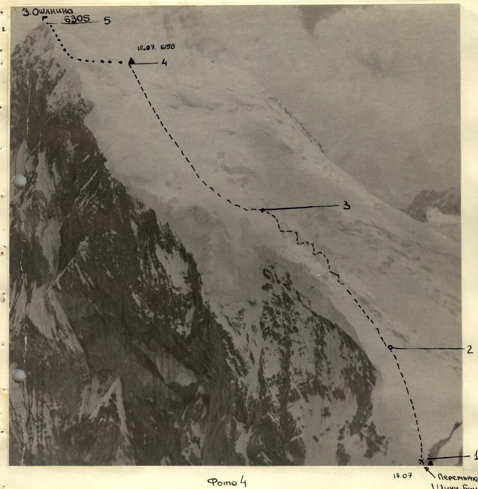
Photo 4. Northern ridge of Zapadny Oshanina peak. For the day, we gained 1000 m in altitude. Overnight at an elevation of 6150 m. Working day lasted 10 hours.
July 19. 3rd day.
Zapadny Oshanina — Centralny Oshanina
Rocks with steepness up to 80°. Belay via pitons. Cold, piercing wind. We departed from the Western ridge at 9:00. Via steep snow-and-ice (up to 50°) and rocky (up to 70°) slopes, we ascended to Zapadny Oshanina peak in 4 ropes. From the summit, we descended along a steep snowy slope (6 ropes) to the saddle between Zapadny and Centralny Oshanina peaks (photo 3). The black and red pinnacles on the saddle were bypassed on the right via steep snow-and-ice slopes. Beyond the red pinnacle, we reached the main ridge, which drops towards the Fortambek glacier with sheer two-kilometer walls. The ridge is lined with numerous cornices hanging towards the Fortambek glacier. Movement along the ridge was alternating with piton belay. We stopped for the night at 20:00 under the rocky tower of Centralny Oshanina peak (photo 5). There were no suitable locations for an overnight stay. On the ridge, we cut through a cornice and constructed two platforms for tents from snow and rocky blocks. The two-kilometer walls towards the Fortambek glacier are scarred by gullies from rockfalls and avalanches. The lower bergschrunds are directly beneath us. For the day, we descended 250 m along steep snow-and-ice slopes from Zapadny Oshanina to the ridge between Zapadny and Centralny Oshanina and traversed 10 ropes along the ridge under the summit tower of Centralny Oshanina. Working day lasted 11 hours. Weather was good. Overnight at an elevation of 6100 m.
July 20. 4th day.
Centralny Oshanina peak
We departed at 9:30. From the overnight location, one rope was used to descend under a grey wall. Then, one rope was used to traverse right under the wall, followed by an ascent up the wall for 3 ropes of 40 m via a poorly defined internal angle.
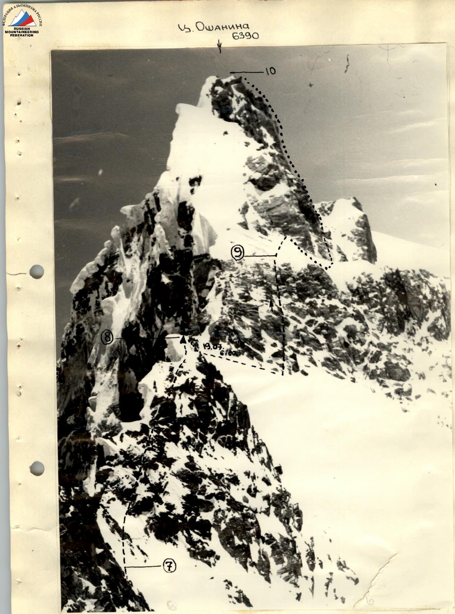
Photo 5. Ascent to Centralny Oshanina peak. Rocks with steepness up to 80°. Belay via pitons. Cold, piercing wind.
After the rocks, we ascended a steep snow-and-ice slope of 50° to the right, up to a rocky shoulder extending west from the rocky bastions of Centralny peak. From the shoulder, we descended along steep slopes down to bypass the bastions, under the snow-and-ice slopes beneath the bastions. We bypassed the bastions on the right via steep snowy slopes, along which we ascended to Centralny Oshanina peak. We reached the summit at 18:00, weather was good. From the summit and the entire traverse ridge, breathtaking views of Korzhenevskaya peak, Kommunizma peak, and all surrounding peaks open up. We descended from the summit (two ropes) to the ridge and set up for the night at 19:30. Working day lasted 10 hours. Overnight at an elevation of 6300 m.
July 21. 5th day
Vostochny Oshanina peak
We departed at 9:00. Movement proceeded along steep snow-and-ice slopes, bypassing from the west the rocky counterfort of Vostochny Oshanina peak (photos 9, 6). After the counterfort, we made a steep ascent vertically upwards towards Vostochny Oshanina peak, and somewhat to the right of it, along steep snow-and-ice slopes. Belay via pitons. We reached the ridge from the south of the peak. We reached the summit at 17:00. We stopped for the night at 19:00. Working day lasted 10 hours. Overnight at an elevation of 6250 m. The overnight location was near the junction of two ridges. One ridge leads to 30 let Sovetskogo Gosudarstva peak, and the second descends towards the Sagrant glacier.
July 22. 6th day.
Descent from Vostochny Oshanina peak to the saddle in the ridge between Vostochny Oshanina and 30 let Sovetskogo Gosudarstva peaks. The traverse from Vostochny Oshanina peak to 30 let Sovetskogo Gosudarstva peak is a jumble of cornices. It is challenging to discern a path for descent to the saddle. Near the summit, we cut through a cornice and commenced descent along steep snow-and-ice slopes towards the saddle in the ridge between Vostochny Oshanina and 30 let Sovetskogo Gosudarstva peaks. This section is very challenging, with loose snow on ice. The descent proceeds continuously under the ridge due to the presence of cornices.
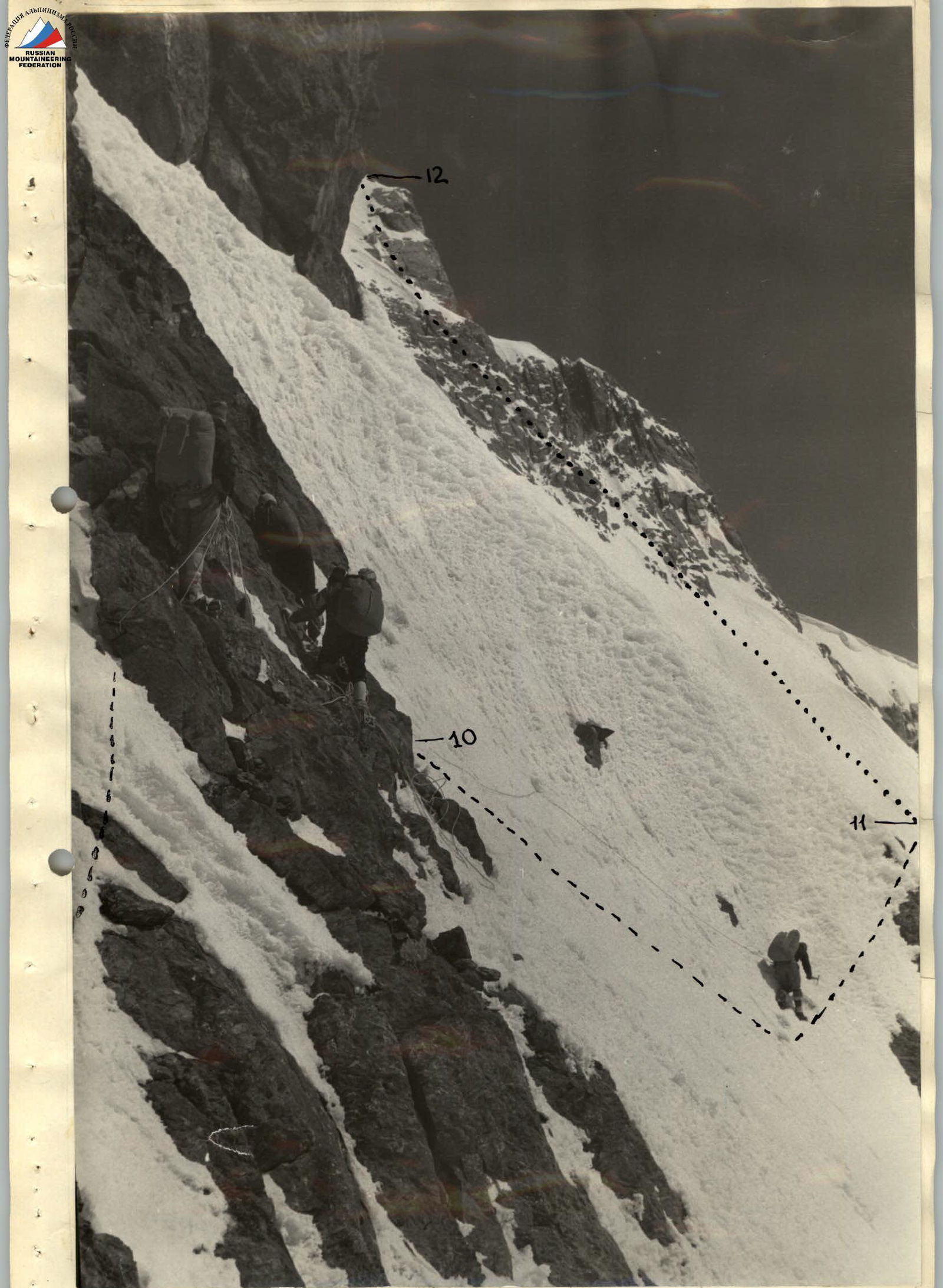
Photo 6. Traverse and ascent along snow-and-ice slopes between.
From the ridge, numerous steep rocky counterforts extend, between which steep snow-and-ice couloirs pass. We cross these counterforts via the couloirs: sometimes using a sports method, and sometimes via rappels. Every 30–35 m, we leave pitons with loops. After 450 m, we descended to the lowest point of the ridge between Vostochny Oshanina and 30 let Sovetskogo Gosudarstva peaks. On the steep snow-and-ice slope under the ridge, we cut out platforms for tents. We stopped for the night at 18:00. Working day lasted 9 hours. Overnight elevation was 6000 m.
July 23. 7th day
Northern ridge of 30 let Sovetskogo Gosudarstva peak.
We departed at 9:00. From the overnight location, movement proceeded under the ridge (due to cornices on the ridge) along steep snow-and-ice slopes. Belay via pitons. Then, we reached the ridge, along which we proceeded under rocky walls. The walls (40–50 m) were traversed "head-on." Belay via pitons. After the walls, a snow-and-ice ridge with cornices led us under a cornice on the northern ridge. We cut through the cornice and emerged onto snowy slopes adjacent to the northern ridge. We stopped for the night at 19:00 on the northern ridge at an elevation of 6250 m. Poor weather in the second half of the day, wind, snowstorm. Working day lasted 10 hours.
July 24. 8th day.
30 let Sovetskogo Gosudarstva peak — descent to the saddle in the ridge between 30 let Sovetskogo Gosudarstva and Moskva peaks.
We departed at 10:00. From the overnight location, along snow-and-ice slopes, slightly to the right of the northern ridge, we moved towards the summit. 30 let Sovetskogo Gosudarstva peak is a tower with sheer walls composed of large rocky blocks (photo 8). Descent proceeded along steep snow-and-ice couloirs towards the saddle between 30 let Sovetskogo Gosudarstva and Moskva peaks. Movement was in three steps, with belay via ice axe, pitons, and rocky outcrops. The direction of movement was guided by the saddle between Moskva and 30 let Sovetskogo Gosudarstva peaks, where we set up tents at 18:00. Working day lasted 8 hours.
July 25. 9th day.
Moskva peak via the northern ridge (Photos 9, 10)
We departed from the overnight location at 9:00. For 30 minutes, along snow-and-ice slopes, we reached the saddle in the ridge between Panoramny and Moskva peaks. From the saddle, we moved along a snowy slope towards snow-covered rocks, via the right part of which we emerged onto a snowy slope that we traversed to the right, below a standalone "finger." The snowy slope was traversed towards rocky walls. The rocky walls were traversed via a steep snowy tongue between them, and we emerged onto a second snow-and-ice slope leading to rocky walls on the ridge. The walls were traversed via a chimney with a plug at the top, the bottom of which was filled with snow. Above the chimney, on the left on the rocks, we left a control cairn. From the chimney, along a snowy slope with rocky inclusions.
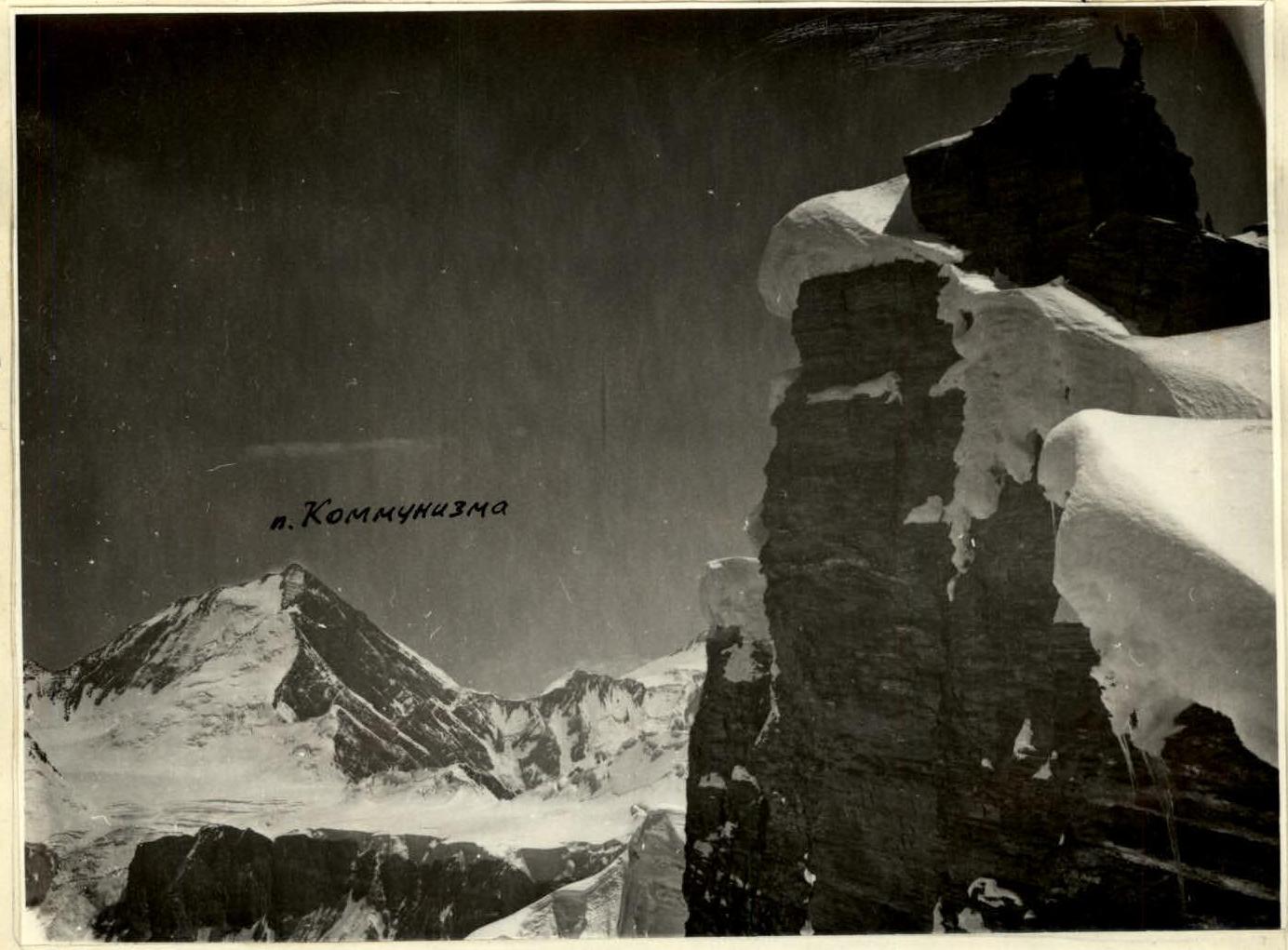
Photo 8. Predsummit rocky tower of 30 let Sovetskogo Gosudarstva peak.
- Kommunizma peak
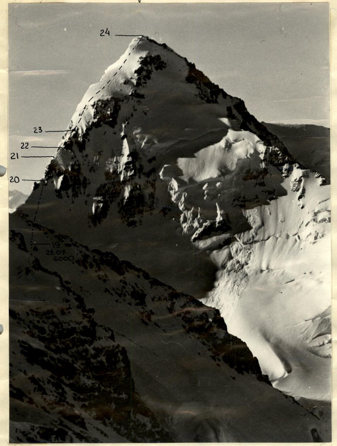
Photo 10. Northern ridge of Moskva peak.
This slope transitions into a presummit slope leading to the Western summit of Moskva peak. The Western summit is located at the junction of the Western and Northern ridges. The main summit is situated to the left. A delicate snow-and-ice ridge with cornices connects the Western summit to the main summit. We accessed the summit via a rocky wall with a steepness of 70°, 2 × 40 m. The main summit is a rocky tower located at the junction of the western and eastern ridges. We descended via the ascent route. We arrived at the overnight location at 20:00. Working day lasted 13 hours. At 21:00, we signaled with three flares from the saddle, marking the completion of the traverse.
July 26. 10th day.
Descent via Sagrant glacier
We departed from the overnight location under the saddle between 30 let Sovetskogo Gosudarstva and Moskva peaks at 9:00. During the day, we traversed two steps of the icefall and stopped for the night on a bend in the Sagrant glacier to the right.
July 27–29.
Sagrant glacier — Dzhirgatal town
We descended the Sagrant glacier, followed the valley of the Sagrant River, and crossed the Bel-Kondu pass into the valley of the Zhuk-su River. Then, we proceeded on foot to Lyakhy village and from there arrived in Dzhirgatal town by car.
V. Route Evaluation and Team Performance Assessment
In terms of its length, altitude, altitude gain, and terrain character, the traverse of Oshanina peaks — 30 let Sovetskogo Gosudarstva peak — Moskva peak can be considered one of the most challenging routes.
The passage of these three beautiful peaks stands out from other options in the area due to its logical and coherent nature. Continuing the traverse in either direction would make it too lengthy and reduce it to a lower altitude level.
The advisability of continuing the traverse to Abalakov peak or Leningrad peak can be considered if an optimal return to the Fortambek glacier via the Pamir Firn Plateau and the "Burevestnik" ridge is necessary.
Based on the experience of previous ascents: Borodkin — Kommunizma peak from Walter glacier, Glukhov — Kommunizma peak via the southern wall, Maksimov — traverse of Nеру peak — Pobeda peak, the team proposes to evaluate the route as Category 6 complexity.
The route demonstrated the good physical and tactical preparedness of the participants. By general consensus, the team's actions should be considered excellent.
Team captain V. Khomutov Team coach Yu. Borodkin
Comments
Sign in to leave a comment