
Ascent Passport
- Ascent class: High-altitude technical climb
- Ascent area: North-Western Pamir, Peter the First Ridge
- Peak, its height, route: Peak 5490 m via the North-Eastern ridge, first ascent
- Difficulty category: 5B
- Route characteristics:
- Height difference: 2290 m
- Average steepness: 55° (from the saddle between Peak 4050 m and the NE ridge of Peak 5490 m)
- Length of sections:
- I–II difficulty category – 2600 m
- III difficulty category – 650 m
- IV difficulty category – 400 m
- V difficulty category – 1620 m
- V–VI difficulty category – 440 m
- Total length: 5710 m
- Pitons used for belaying:
- Rock pitons: 85 pcs
- Ice pitons: 22 pcs
- Total climbing hours: 81.5
- Number of bivouacs and their characteristics: 5 bivouacs:
- 1st – on the summit of Peak 4050 m below the NE ridge;
- 2nd – on the route in a tent;
- 3rd, 4th, 5th – at an altitude of 5200 m.
- Surname, initials of team leaders and participants, their sports qualification:
- Turkevich M.M. – CMS – team leader
- Monogarov V.L. – MS – participant
- Polevoy G.V. – CMS – participant
- Dubinin V.N. – CMS – participant
- Polevoy V.V. – CMS – participant
- Kharinik I.V. – CMS – participant
- Kuravlev B.F. – 1st sports category – participant
- Tarasenko A.I. – 1st sports category – participant
- Team coaches:
- Polevoy G.V., Monogarov V.D.
- Dates:
- Departure to the route: June 8, 1979
- Return to the base camp: June 13, 1979
Brief Geographic and Sports Characteristics of the Area
The alpinist expedition of the Ukrainian Council of Trade Unions, the Central Committee of the LKSMU, and the Republican Sports Committee worked in the Peter the First Ridge area in the North-Western Pamir in 1979, just like in the previous season.
The Peter the First Ridge stretches for 160 km from Peak Kommunizma in the east to low, grassy mountains in the west. The ridge is a watershed between the Obikhingou and Rumbou rivers. The rivers in this area are not very full-flowing, and fording is possible. The snow-capped peaks of the ridge's spurs gradually give way to green hills. The rock formations are mainly of volcanic origin, fragile, and significantly weathered.
The area has significant glaciation, with glacier tongues descending into the valleys down to altitudes of 3500 m. In their lower parts, the glaciers are typically:
- heavily crevassed,
- abundant with icefalls,
- fractured,
- heavily littered with surface moraines.
The upper parts of the glaciers are snow-covered. There are many hanging glaciers on the slopes of the ridges and numerous snow cornice on the crests.
The weather in late May and early June in this area is quite unstable, often with snowfall in the base camp (at an altitude of 3100 m) in the second half of the day. The air temperature fluctuates between +5°C and +15°C during the day and drops to –10°C at night. The wind is moderate and cold.
The area is very interesting from a sports perspective. Hundreds of peaks, many of which exceed 5000 m, await their conquerors. They rise steeply above the valleys and typically do not have straightforward routes. The paths from the north are particularly challenging: steep grassy and talus slopes, broken rocky ridges, followed by even steeper ice and firn slopes, and complex rock walls.
The area is poorly explored by researchers and even less so by alpinists. Since the Russian researcher V.F. Oshandin partially explored and described the powerful mountain chain in 1876, naming it after Peter the First, and V.I. Lipsky surveyed some of the glaciers in this area in 1899, the Peter the First Ridge has been visited by only a few scientific expeditions.
The first alpinist expedition to this area took place only in 1947 when a group led by E.M. Abalanov conquered the first peak in the Peter the First Ridge, naming it Peak 30th Anniversary of the Soviet State. Since then, several other peaks have been conquered, mainly in the eastern part of the ridge and its spurs (Peaks Leningrad, Abalakova, Moskvy, Sudoeva, etc.). However, the northern spurs of the central part of the Peter the First Ridge have been almost untouched by alpinists.
In 1978, an expedition by Ukrprofspilka and the Central Committee of the LKSMU began to explore this area, conquering several peaks for the first time: Peak 5462 m – Peak Heroes of Malaya Zemlya, Peak 5105 m – Peak 60th Anniversary of VLKSM, and others.
In 1979, the exploration of this area continued, with Peak 5490 m, located slightly east of Peak 5462 m, being the main objective after extensive helicopter reconnaissance.
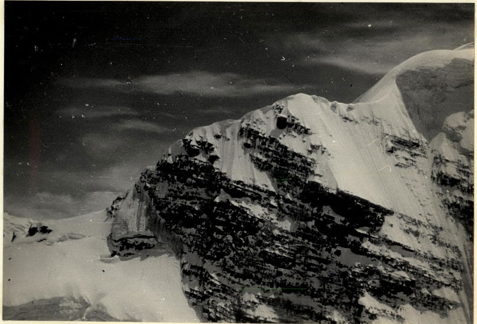
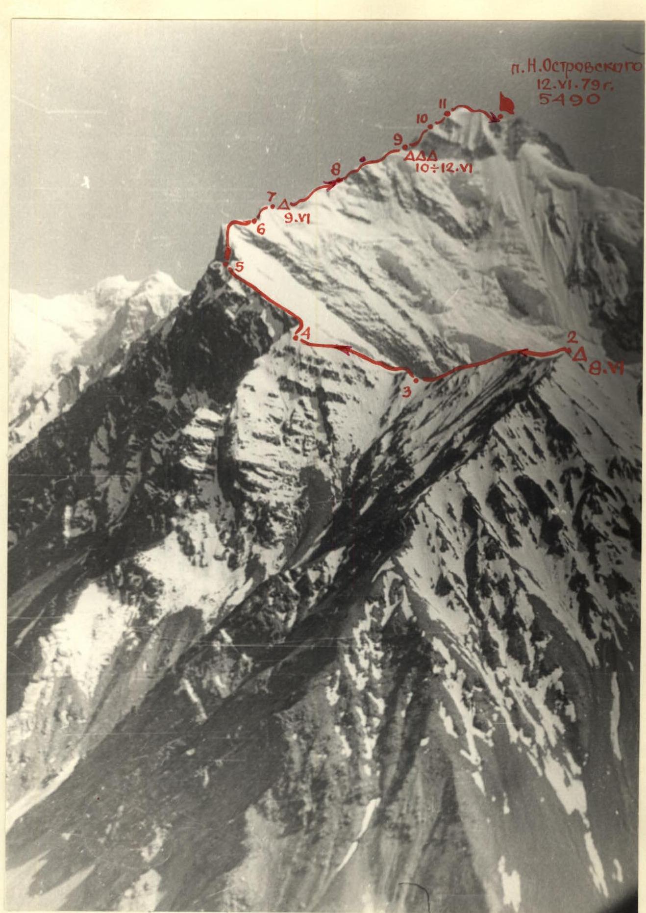 Peak 4050 and the North-Eastern ridge of Peak 5490
Ascent Description
June 8, 1979
The group departed from the base camp located in the Kunsel tract at an altitude of 3100 m at 10:00, heading up a stream in a northeast direction, to the right of the grassy ridge leading to Peak 4050 m. Upon reaching the not clearly defined Western counterfort of this ridge, we began ascending it via steep grassy slopes to the left. After 300 m, we reached a snow-covered slope. The snow was loose, up to 40 cm deep or more. The slope's steepness reached 45° but then eased to 40°. After traversing the snow slope parallel to the ridge of Peak 4050 m, we reached a steep 45° snow-covered rocky ridge of the counterfort. Walking on the snow slope was challenging due to the loose snow that did not provide support, causing us to sink above the knee, sometimes up to the waist; self-belaying was done with an ice axe. The ridge was a heavily weathered, snow-covered rocky crest with many "live" rocks, requiring careful navigation. We ascended the ridge to the left, reaching the NE ridge of Peak 4050 m. Further along the snow-covered, heavily weathered rocky ridge, we passed several small (up to 10 m high) "gendarmeries," mostly directly, with some bypassed on the right as we proceeded, and reached the summit of Peak 4050 m. From the summit, a large snow cornice hung to the east; to its right, on the main slope, we dug out platforms for the night's bivouac. Time – 17:00.
June 9, 1979
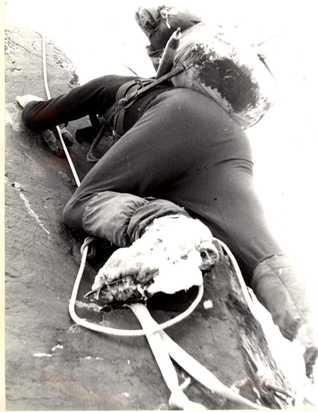
Departure from the bivouac at 6:00. After traversing the heavily weathered rocks of the ridge interspersed with sections of deep, loose snow, we ascended a steep snow-and-ice slope to the saddle between Peak 4050 m and the beginning of the NE ridge of Peak 5490 m. The height of the saddle is 3960 m. Until this point, or simultaneously, self-belaying was done with an ice axe. On the saddle, we tied in and put on crampons. We ascended with alternating belays up a steep 55° snow-and-ice slope to the right of the ridge. The snow was deep and loose but in many places shallow, sliding over the ice "cushion." Then, we reached a small snow mulde under the first rocky "gendarmerie" on the ridge. We passed the "gendarmerie" directly with piton belays, then followed the sharp snow ridge to the second rocky "gendarmerie," which we bypassed on the right, having driven one piton into the rocks for belay. After traversing the snow ridge with several steep sections up to 50°, we approached the base of a steep 70° snow-and-ice ridge (similar to a snow-and-ice "belt" on North Ushba). This section was traversed with tension belays, having driven two ice pitons; the snow was loose but deep, sliding underfoot on the ice.
In the upper part of the ridge, we passed steep, relatively solid snow rocks, having driven four rock pitons, then a snow-and-ice shoulder, and again a rocky "gendarmerie," which we passed directly, having driven two rock pitons.
Further along the sharp snow ridge, to the right and below its bend, where three ice pitons were driven into the cleaned ice, we approached the next "gendarmerie" and bypassed it on the right as we proceeded on loose snow. Here, six rock pitons were driven for belaying and rope protection.
Beyond the "gendarmerie," along the snow-and-ice spur of the ridge, where one ice piton was used, we reached a broad snow ridge with a mulde. Here, we trampled a snow platform and organized a bivouac. Altitude – 4650 m, time – 17:00.
June 10, 1979
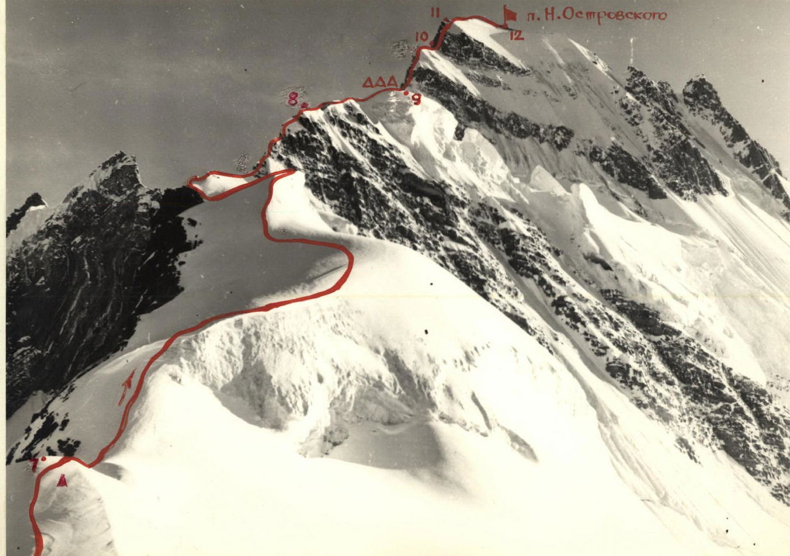
Departure from the bivouac at 7:00. The path followed a snow-and-ice ridge with three steep sections up to 70°, alternating with snow-covered rocky walls up to 80° steep, with small 243 m overhanging sections. Movement was with alternating belays; on complex sections, rope protection was installed. Eight rock pitons and four ice pitons were used. Then, a rocky, sharp, and steep 80°–85° snow-covered and icy ridge (eight rock pitons) led us again to a snow-and-ice ridge with three ascents. The first ascent, with a steepness of 75°, was traversed with loop belays, manual steps, and hanging rope protection. Here, three ice pitons were driven. The second and third ascents, with steepness of 55°–65°, were traversed on crampons with alternating belays via an ice axe and an ice piton. Then, along a narrow snow-and-ice ridge, we reached a snow shoulder before the first pre-summit rocky belt. On the shoulder, the snow was deep and loose. We constructed platforms for a bivouac. Altitude – 5200 m. Time – 17:00.
Note: Throughout this day, we wore crampons.
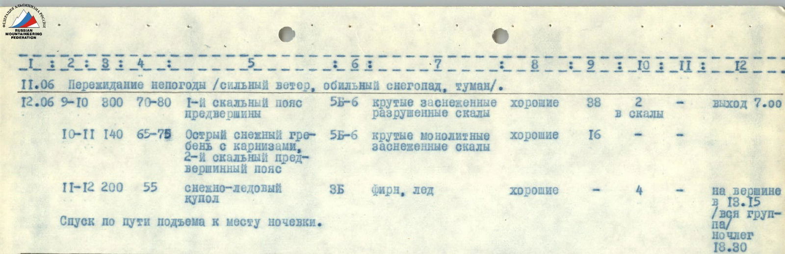
June 11, 1979
On the night of June 10–11, a storm began: strong gusty winds, heavy snowfall, visibility 5–80 m. The entire day on June 11 was spent weathering the storm; departure was impossible.
June 12, 1979
Departure from the bivouac at 7:00. We put on crampons again. A snow ascent of 45°–50° led us to the base of the first pre-summit rocky belt. The rocks were steep, 70°–80°, weathered, and snow-covered; the 160 m section was traversed with thorough belaying, driving 38 rock pitons and 2 ice pitons into the rocks. The upper part of the wall turned into a steep snow-covered slab with a steepness of 70° (two ropes), composed of conglomerate. Further along a sharp snow ridge with cornices, with a steepness of 70°, we approached the second pre-summit rocky belt. The rocks were monolithic, with a steepness of 65°–75°, snow-covered, and in places wet and slippery, extending 60 m. Here, 16 rock pitons were driven. Then, with alternating belays (on crampons), along a steep 60° firn ridge, followed by an ice dome with a steepness of 55° (four ice pitons were driven), we reached the highest point of Peak 5490 m. Time – 13:15.
We began our descent at 14:00, following the ascent route and using rope protection.
At 18:30, the group descended to the bivouac at an altitude of 5200 m.
June 13, 1979
At 8:00, the group continued the descent along the ascent route. On complex sections, rope protection with rock and ice pitons was used. We descended to the base camp at 17:00.
Route Conclusion
The route traversed by the group represents a first ascent of Peak 5490 m, which is proposed to be named Peak Nikolai Ostrovsky, via its North-Eastern ridge through Peak 4050 m.
The route is extensive, combined, with numerous steep snow-and-ice ascents, rocky "gendarmeries," and complex rocky walls of the 1st and 2nd pre-summit belts. This required the application of the entire arsenal of alpinist techniques: various rock pitons, ice pitons (regular and tubular), wedges, ladders, and chocks. The rocks in many sections were weathered, icy, and heavily snow-covered, demanding increased attention and more thorough belaying during their traversal. The entire route was traversed wearing crampons.
Overall, the ascent route is entirely logical, safe, diverse, and very interesting from a sports perspective.
The group believes that the traversed route, due to its complexity, length, and steepness, deserves to be classified as a 5B category route.
It is also worth noting that the ascent, in terms of its timing and conditions, was essentially a winter ascent, as no alpinist groups had previously climbed in this area at this time (early June). Moreover, the spring and summer in Tajikistan in general, and in the Peter the First Ridge area in particular, were delayed in 1979. The weather during our expedition was quite unstable: cold gusty winds, frequent snowfalls, and fog.
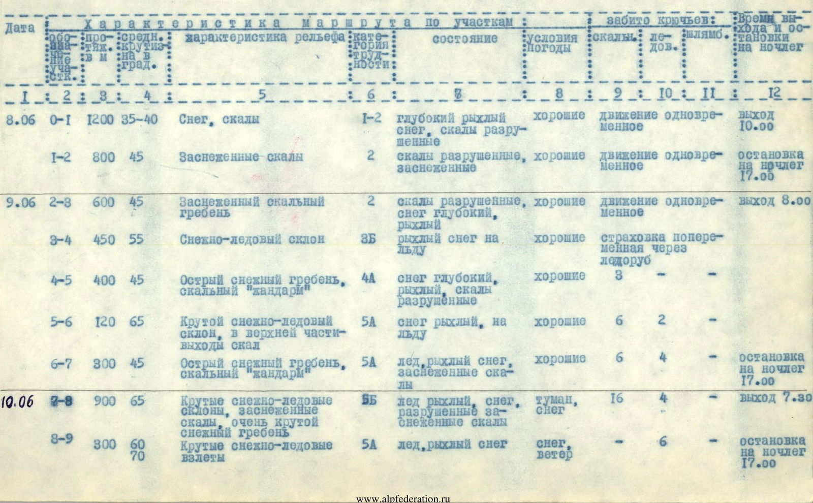
Table of Main Route Characteristics
| Date | Section | Length (m) | Avg. Steepness (deg.) | Relief Characteristics | Diff. Cat. | Condition | Weather Conditions | Rock Pitons | Ice Pitons | Departure and Overnight Stop Time |
|---|---|---|---|---|---|---|---|---|---|---|
| 8.06 | R0–R1 | 1200 | 35–40 | Snow, rocks | 1–2 | Deep loose snow, weathered rocks | Good | – | – | Departure 10:00 |
| R1–R2 | 800 | 45 | Snow-covered rocks | 2 | Weathered rocks, snow-covered | Good | – | – | Overnight stop 17:00 | |
| 9.06 | R2–R3 | 600 | 45 | Snow-covered rocky ridge | 2 | Weathered rocks, deep loose snow | Good | – | – | Departure 8:00 |
| R3–R4 | 450 | 55 | Snow-and-ice slope | 3Б | Loose snow on ice | Good | – | – | Alternating belays via ice axe | |
| R4–R5 | 400 | 45 | Sharp snow ridge, rocky "gendarme" | 4А | Deep loose snow, weathered rocks | Good | 3 | – | – | |
| R5–R6 | 120 | 65 | Steep snow-and-ice slope, upper part – rock outcrops | 5А | Loose snow on ice | Good | 6 | 2 | – | |
| R6–R7 | 300 | 45 | Sharp snow ridge, rocky "gendarme" | 5А | Ice, loose snow, snow-covered rocks | Good | 6 | 4 | Overnight stop 17:00 | |
| 10.06 | R7–R8 | 900 | 65 | Steep snow-and-ice slopes, snow-covered rocks, very steep snow ridge | 5Б | Ice, snow, weathered snow-covered rocks | Fog, snow | 16 | 4 | Departure 7:30 |
| R8–R9 | 300 | 60–70 | Steep snow-and-ice ascents | 5А | Ice, loose snow | Snow, wind | 6 | – | Overnight stop 17:00 | |
| 11.06 | Weathering bad weather: strong wind, heavy snowfall, fog. | |||||||||
| 12.06 | R9–R10 | 300 | 70–80 | 1st rocky pre-summit belt | 5Б–6 | Steep snow-covered weathered rocks | Good | 38 | 2 (in rocks) | Departure 7:00 |
| R10–R11 | 140 | 65–75 | Sharp snow ridge with cornices, 2nd rocky pre-summit belt | 5Б–6 | Steep monolithic snow-covered rocks | Good | 16 | – | – | |
| R11–R12 | 200 | 55 | Snow-and-ice dome | 3Б | Firn, ice | Good | – | 4 | On summit at 13:15 (whole group); overnight stop 18:30 | |
| Descent along the ascent route to the overnight stop. | ||||||||||
| 13.06 | Descent to base camp along the North-Eastern ridge via the ascent route. | Departure 8:00, return to base camp 17:00 |
Total pitons driven: 85 rock, 22 ice. Total height difference: 2290 m. Route length: 5710 m. Total climbing hours: 81.5 h.
Upper Part of the Ridge
Section 7–8. Next Wall.
Section R7–R8 (Upper Part). Steep Snow-Covered Rocky Belts
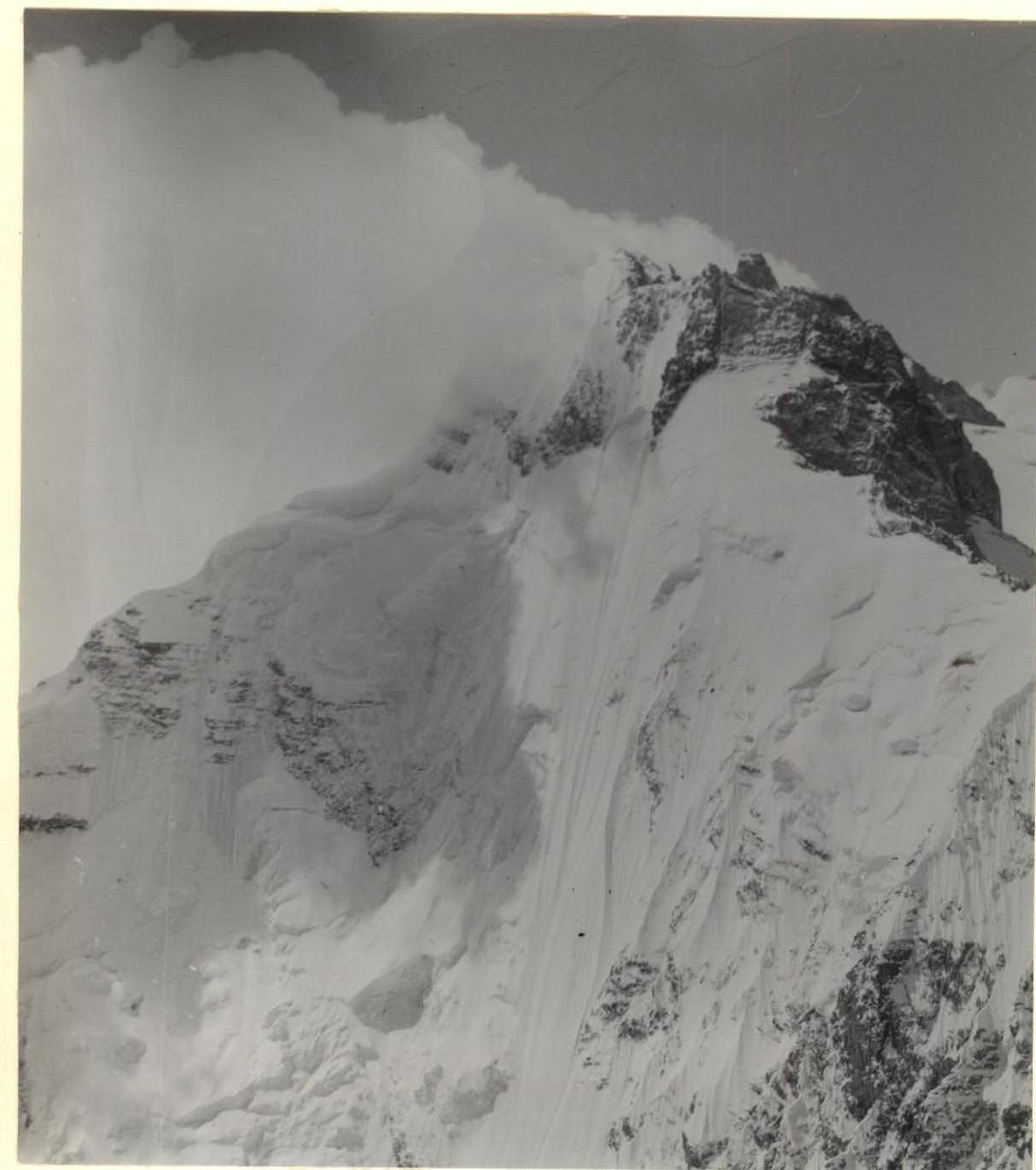 Section 9-10 and 10-11. Upper part of the route: 1st and 2nd (in cloud). Rocky belts of the pre-summit tower.