
"Peak Oleg Mkrtchan", height 4980 m. "Kurayshapak" ridge, North-Eastern spurs of the Peter the First ridge, PAMIR. REPUBLIC OF TAJIKISTAN.
Ascent Passport
- Country, mountain system name:
- Ascent class:
- Ascent area, ridge:
- Peak, its height, ascent route:
- Proposed difficulty category:
- Route characteristics: height difference: length of sections of 4–5 complexity categories: average steepness:
- Number of driven pitons or used placement elements:
for insurance:
- rock — 23
- ice — 45
- pitons / placements — 9
- Total time on the route:
- Number of overnight stays and their characteristics:
- Surname, first name, patronymic of the leader, participants, and their qualification:
- Team coach:
- Date of departure on the route and return:
Republic of Tajikistan, Pamir. High-altitude. North-Eastern spurs of the Peter the First ridge.
"Peak Oleg Mkrtchan" 4980 m, North-Eastern ridge.
4B, combined.
- 980 m
- 600 m
- 35°
for artificial anchor point
ascent to the "Kurayshapak" pass 11 hours, ascent from the initial bivouac to the summit 7 hours 05 minutes. Total: 18 hours 05 minutes.
Descent to the "Kurayshapak" pass 3 hours 30 minutes, descent to the base camp 4 hours. Total: 7 hours 30 minutes.
2 overnight stays, good.
- Kaifadzhyan Sergey Amatunovich, 1st sports category, Ukraine.
- Sharipov Anatoly Raimdzhanovich, Candidate for Master of Sports, Republic of Tajikistan.
- Kovalev Sergey Viktorovich, Master of Sports International Class, instructor 3rd category, Ukraine.
August 25, 2003 – August 27, 2003
Table № 2
Ascent date: August 26, 2003
| № | Section characteristics | Pitons used | Travel time. | |
|---|---|---|---|---|
| For insurance | For artificial anchor point creation | Time spent at bivouac. Overnight conditions. | ||
| R0–R1 | Rocks, scree, 500 m | — | — | Overnight stay good. Start 5:00. Travel time: 30 minutes. |
| R1–R2 | Snow slope, 450 m, 40° | — | — | Travel time: 40 minutes. |
| R2–R3 | Saddle 20 m, equipment preparation | — | — | Travel time: 10 minutes. |
| R3–R4 | Snow-ice wall 200 m, 40–50° | 15 ice screws | — | Travel time: 45 minutes. |
| R4–R5 | Shelf 5 m | — | — | Travel time: 0:05 minutes. |
| R5–R6 | Rocks 15 m, category 4 | 2 rock pitons | — | Travel time: 25 minutes. |
| R6–R7 | Shelf 5 m | — | — | Travel time: 0:05 minutes. |
| R7–R8 | Rocks 30 m, 60°, category 4 | 2 placements, 4 rock pitons | — | Travel time: 35 minutes. |
| R8–R9 | Shelf 5 m | — | — | Travel time: 0:05 minutes. |
| R9–R10 | Rocks 30 m, 60°, category 4 | 1 placement, 5 rock pitons | — | Travel time: 35 minutes. |
| R10–R11 | Gendarme 15 m | — | — | Travel time: 10 minutes. |
| R11–R12 | Rock ascent 15 m, 50°, category 4 | 2 rock pitons | — | Travel time: 20 minutes. |
| R12–R13 | Rocks 10 m, 40° | 2 rock pitons | — | Travel time: 10 minutes. |
| R13–R14 | Chimney 10 m, category 5 | 3 placements, 4 rock pitons | — | Travel time: 20 minutes. |
| R14–R15 | Shelf 5 m | — | — | Travel time: 0:05 minutes. |
| R15–R16 | Chimney 10 m, category 5 | 3 placements, 4 rock pitons | — | Travel time: 20 minutes. |
| R16–R17 | Shelf 8 m | — | — | Travel time: 0:05 minutes. |
| R17–R18 | Ice wall 200 m, 50° | 19 ice screws | — | Travel time: 45 minutes. |
| R18–R19 | Bridge 5 m | — | — | Travel time: 0:05 minutes. |
| R19–R20 | Ice wall 70°, 25 m | 5 ice screws | — | Travel time: 20 minutes. |
| R20–R21 | Snow ridge 50°, 60 m | — | — | Travel time: 10 minutes. |
| R21–R22 | Snow-ice ridge 60°, 60 m | 6 ice screws | — | Travel time: 20 minutes. |
| Total: | 45 ice screws, 23 rock pitons, 9 placements | 7 hours 05 minutes. |
Route diagram in UIAA symbols
"Peak Oleg Mkrtchan" 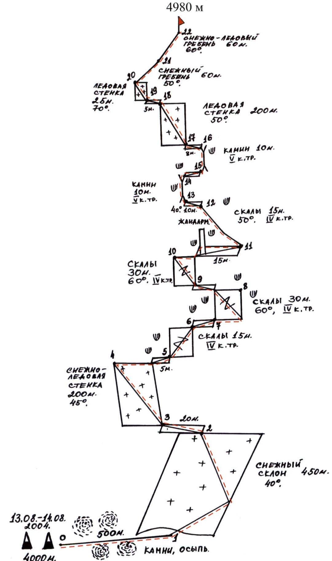
Description of first ascent routes to Peak O. Mkrtchan. Republic of Tajikistan. Pamir. North-Eastern spurs of the Peter I ridge
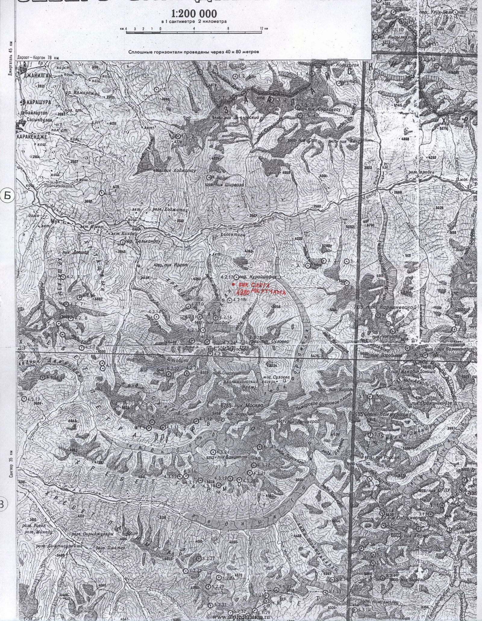
From the village of Belkondon, 4–5 people via the "Belkondon" pass to the "Sugran" valley. Then from the "Sugran" meadow through the "Irget" pass (3800 m) descend to the slopes of "Irget" to the cliffs of the Muksu River. Then overcome the "Khadyrsha" pass, descend down and cross the Khadyrsha River along the moraine along the "Khadyrsha" glacier, walk to the "Khadyrsha" meadow in front of the "Kurayshapak" pass, which is located at an altitude of 3000 m at the "Khadyrsha" glacier opposite the "Kurayshapak" pass and the "Shafak" glacier.
Peaks and passes in the area of the "Kurayshapak" pass:
- "Peak Oleg Mkrtchan" 4980 m — the peak is located northwest of the "Kurayshapak" pass and is the initial high point of the "Kurayshapak" ridge, which originates from the "Kurayshapak" pass (4512 m);
- Behind "Peak Oleg Mkrtchan" 4980 m, continuing the "Kurayshapak" ridge to the west of it is "Peak Ukraine" 5030 m in the form of a trapezoid-shaped trident;
- Further west of "Peak Ukraine" (5030 m) is the "Sasun" pass (4667 m), from which "Peak Armenia" (5495 m) rises to the west;
- "Peak Armenia" is located between the "Sasun" pass 4667 m and the "Khadyrcha" pass 5259 m, behind which is the "Shapak" peak 5667 m.
"Peak Oleg Mkrtchan" 4980 m via the North-Eastern edge, route is snow-ice 4B category. Fig. 1 (Kaifadzhyan S.A. Ukraine, Sharipov A.R. Tajikistan), first ascent: August 26, 2003, repeat ascent: August 14, 2004.

"Priroda" Center
PRE-USHCHEVENNY SCIENTIFIC-RESEARCH AND PRODUCTION CENTER "PRIRODA"
Climbing Department
ALL-UNION COUNCIL OF THE ALL-UNION VOLUNTARY PHYSICAL CULTURE AND SPORTS SOCIETY OF TRADE UNIONS
Peak Oleg Mkrtchan 4980 m
Via the North-Eastern ridge, from the "Kurayshapak" pass, route is combined 4B category. Kaifadzhyan S.A. (Ukraine).
From the "Khadyrsha" valley alpine camp 3000 m, a group of 2 people ascended to the "Kurayshapak" pass 4512 m. The route is combined, with an ascent angle of 45–50° in some places.
Then from the pass, they descended down the scree and slightly to the left, at an altitude of 4000 m, they set up an initial bivouac on the moraine.
Departure at 5:00:
- Move along the moraine to the left into the glacier cirque;
- Walk along the glacier 450–500 m straight up the snow-ice slope;
- Reach the North-Eastern shoulder, from the very summit — to the saddle between the "Kurayshapak" pass and the beginning of the wall of "Peak Oleg Mkrtchan";
- Then slightly to the left and up along the North-Eastern edge, North-Eastern wall, along the snow-ice route, with an ascent angle of 45–50° — 200 m.
Further:
- Ascend to the rocks on the right and to the sheer stone outcrops on a shelf under overhanging rocks;
- Up 10–15 m;
- Traverse 2–4 m to the right along destroyed rocks, 3–4 complexity category;
- 20–30 m along rocks of 4–5 complexity category up;
- Left 2–4 m along rocks;
- Exit to the ice wall at an angle of 55–60°;
- Bypassing gendarmes and rock ascents on the right side, exit along steep rocks of 4–5 complexity category to the middle rock belt of the North-Eastern edge;
- 10–15 m along rocks of 4 complexity category;
- 10 m vertical internal corner of 5 complexity category;
- Rounding to the right side 5 m;
- Climb straight up again;
- 10 m along rocks and stones along the internal corner;
- Then along small rock outcrops, move left about 8 m and ascend to the left side of the shelf — the place for pulling up backpacks.
From the shelf:
- 150–200 m up, slightly to the left, along the snow-ice wall at an angle of 50° (ice tools, short ice screws) — exit to a snow shelf;
- Further to the left, along the ice wall up, 25 m at an angle of 70°, 4–5 complexity category;
- After ascending, continue slightly to the right along the edge at 45–50°, 50–60 m, 3–4 complexity category;
- Then straight up to the very summit — 50–70 m along a snow slope at an angle of 60°.
The ascent took 7 hours 05 minutes during the first ascent, and 6 hours 30 minutes during the second ascent. At the summit, a large flat stone lies at first, on which a cairn was installed during the initial ascent on August 26, 2003, where a note was placed in a tube with the date of ascent and the assignment of a name to the peak. During the repeat ascent on August 14, 2004, at the summit, from the installed cairn in the direction of the west on its pointed peak, a stainless steel metal disk with a diameter of 35 cm was installed with an image of the patron Oleg Mkrtchan and the name of the peak; slightly below, a rectangular plaque with the names of the first ascenders and dates.
Ascent Passport. Table № 1
- Country, mountain system name:
- Ascent class:
- Ascent area, ridge:
- Peak, its height, ascent route:
- Proposed difficulty category:
- Route characteristics: height difference: length of sections of 4–5 complexity categories: average steepness:
- Number of driven pitons or used placement elements:
for insurance:
- rock — 21
- ice — 41
- pitons — 7
- placements — 7
- Total time on the route:
- Number of overnight stays and their characteristics:
- Surname, first name, patronymic of the leader, participants, and their qualification:
- Team coach:
- Date of the second ascent, departure on the route, and return:
Republic of Tajikistan, Pamir. High-altitude. North-Eastern spurs of the Peter the First ridge. "Peak Oleg Mkrtchan" 4980 m — North-Eastern ridge.
4B, combined. 980 m. 600 m. 35°.
for artificial anchor point
ascent to the "Kurayshapak" pass 11 hours, ascent from the initial bivouac to the summit 6 hours 30 minutes. Total: 17 hours 30 minutes. Descent to the "Kurayshapak" pass 3 hours 30 minutes, descent to the base camp 4 hours. Total: 7 hours 30 minutes.
2 overnight stays, good.
Kaifadzhyan Sergey Amatunovich, 1st sports category, Ukraine. Sharipov Anatoly Raimdzhanovich, Candidate for Master of Sports, Republic of Tajikistan. Kovalev Sergey Viktorovich, Master of Sports International Class, instructor 3rd category, Ukraine.
August 13, 2004 – August 15, 2004
Table № 2
Date of the second ascent: August 14, 2004
| № | Section characteristics | Pitons used | Travel time. |
|---|---|---|---|
| For insurance | Time spent at bivouac. Overnight conditions. | ||
| R0–R1 | Rocks, scree, 500 m | — | Overnight stay good. Start 4:30. Travel time: 25 minutes. |
| R1–R2 | Snow slope, 450 m, 40° | — | Travel time: 30 minutes. |
| R2–R3 | Saddle 20 m, equipment preparation | — | Travel time: 10 minutes. |
| R3–R4 | Snow-ice wall 200 m, 40–50° | 14 ice screws | Travel time: 40 minutes. |
| R4–R5 | Shelf 5 m | — | Travel time: 0:05 minutes. |
| R5–R6 | Rocks 15 m, category 4 | 2 rock pitons | Travel time: 25 minutes. |
| R6–R7 | Shelf 5 m | — | Travel time: 0:05 minutes. |
| R7–R8 | Rocks 30 m, 60°, category 4 | 2 placements, 4 rock pitons | Travel time: 30 minutes. |
| R8–R9 | Shelf 5 m | — | Travel time: 0:05 minutes. |
| R9–R10 | Rocks 30 m, 60°, category 4 | 1 placement, 4 rock pitons | Travel time: 30 minutes. |
| R10–R11 | Gendarme 15 m | — | Travel time: 10 minutes. |
| R11–R12 | Rock ascent 15 m, 50°, category 4 | 2 rock pitons | Travel time: 20 minutes. |
| R12–R13 | Rocks 10 m, 40° | 1 rock piton | Travel time: 10 minutes. |
| R13–R14 | Chimney 10 m, category 5 | 2 placements, 4 rock pitons | Travel time: 20 minutes. |
| R14–R15 | Shelf 5 m | — | Travel time: 0:05 minutes. |
| R15–R16 | Chimney 10 m, category 5 | 2 placements, 4 rock pitons | Travel time: 20 minutes. |
| R16–R17 | Shelf 8 m | — | Travel time: 0:05 minutes. |
| R17–R18 | Ice wall 200 m, 50° | 17 ice screws | Travel time: 40 minutes. |
| R18–R19 | Bridge 5 m | — | Travel time: 0:05 minutes. |
| R19–R20 | Ice wall 70°, 25 m | 5 ice screws | Travel time: 20 minutes. |
| R20–R21 | Snow ridge 50°, 60 m | — | Travel time: 10 minutes. |
| R21–R22 | Snow-ice ridge 60°, 60 m | 5 ice screws | Travel time: 20 minutes. |
| Total: | 41 ice screws, 21 rock pitons, 7 placements |
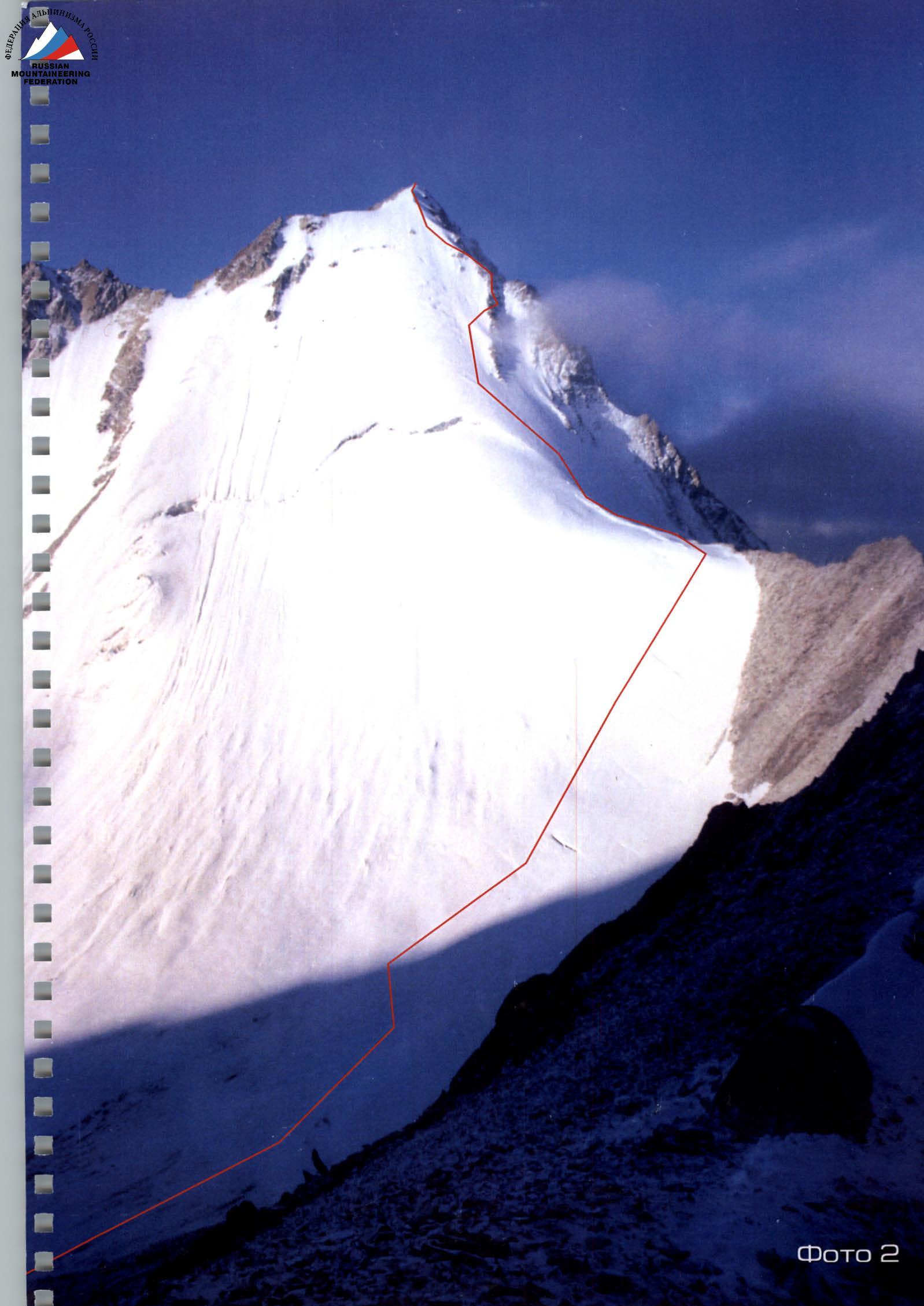
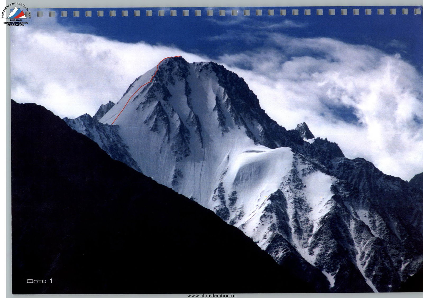
Photo 1
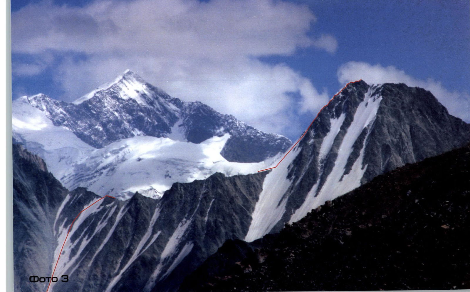
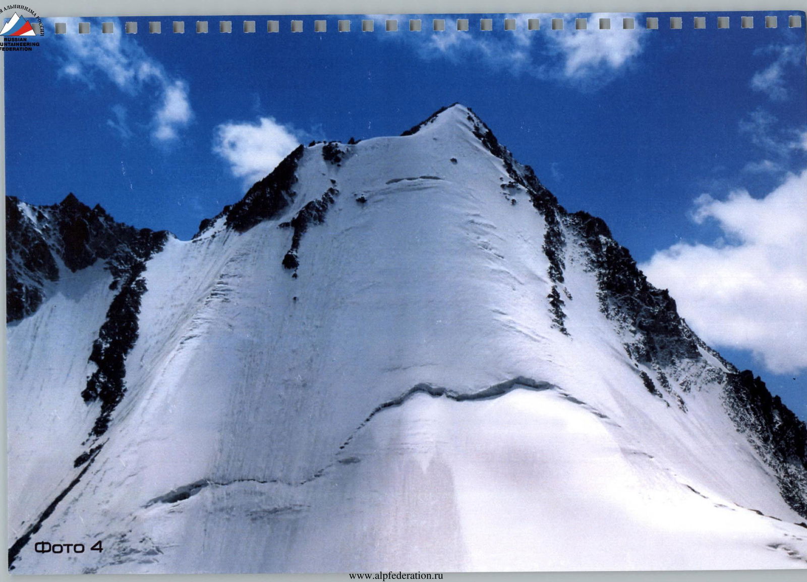
Photo 4
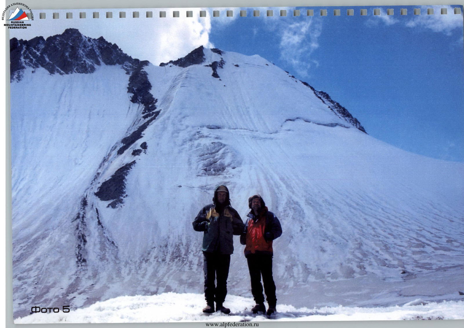
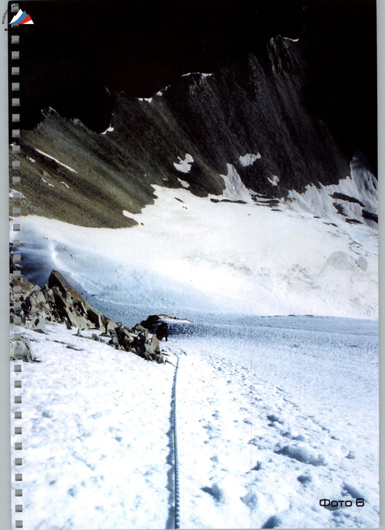
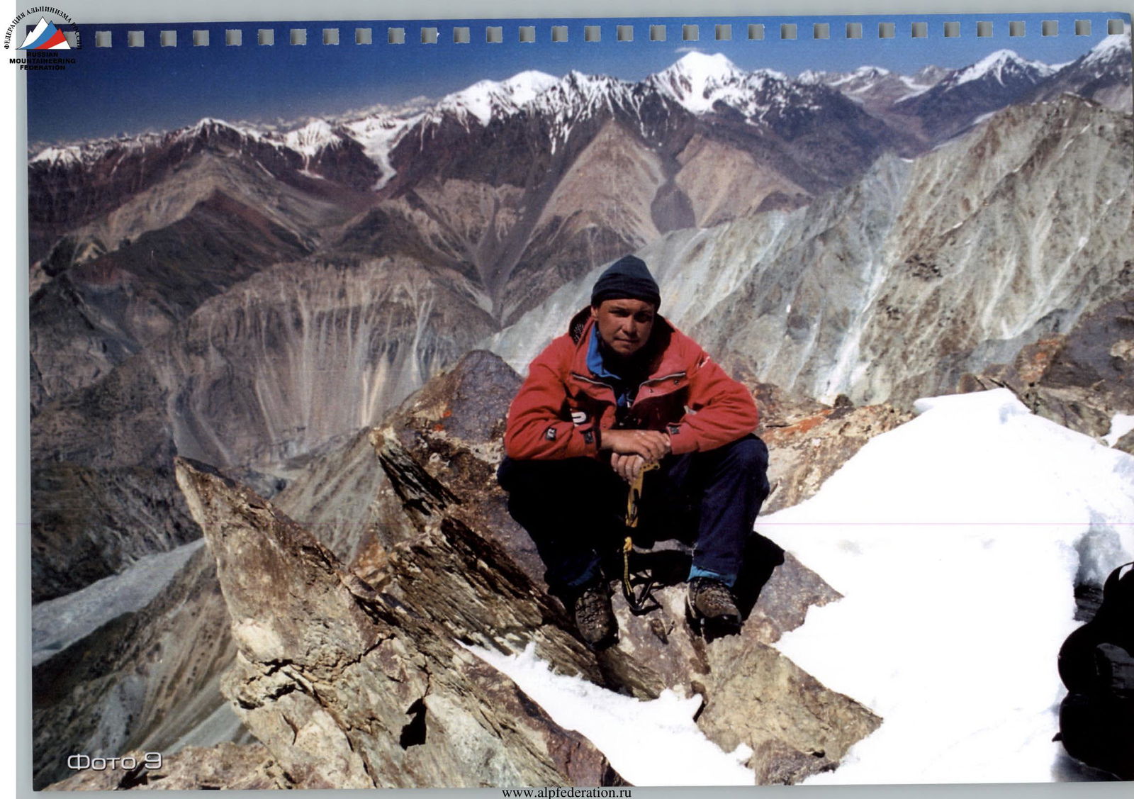
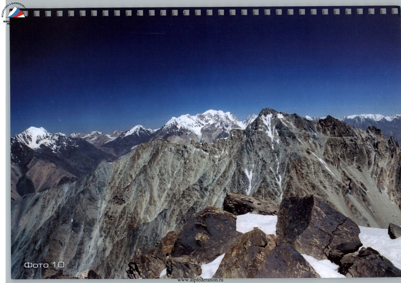
Photo 10
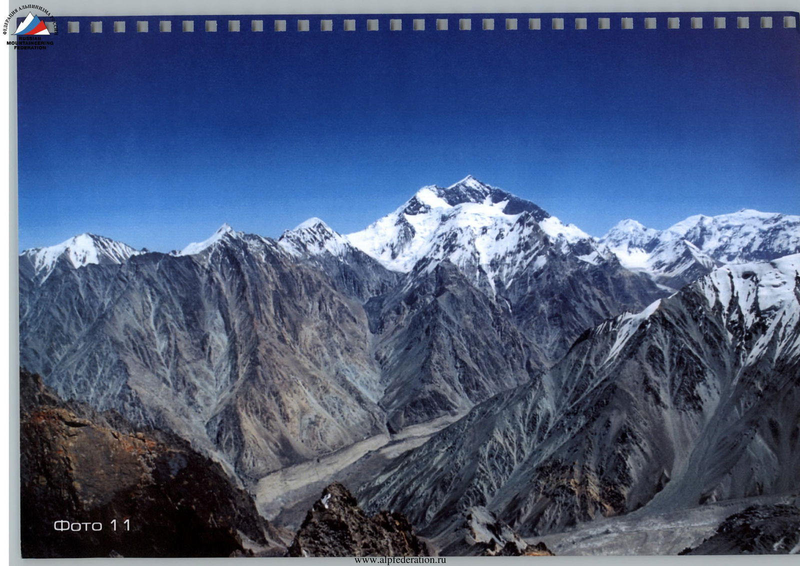
Photo 11
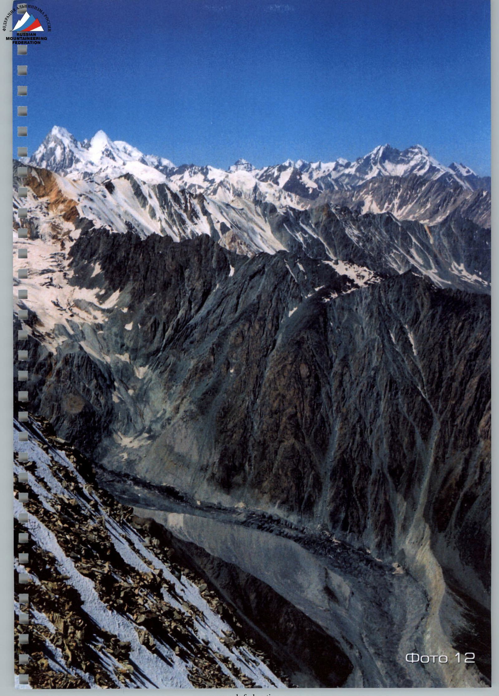
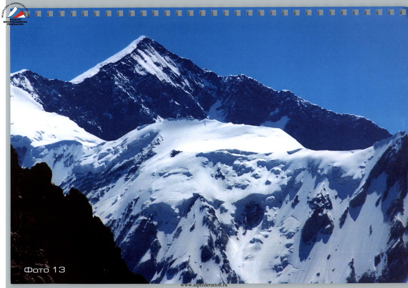
Photo 13

Photo 14
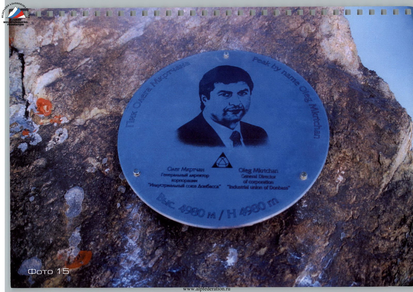
Photo 15
The first ascent was made on August 26, 2003, by climbers:
- Sergey Kaifadzhyan (Ukraine)
- Anatoly Sharipov (Tajikistan)
Repeat ascent with the installation of a sign in 2004.
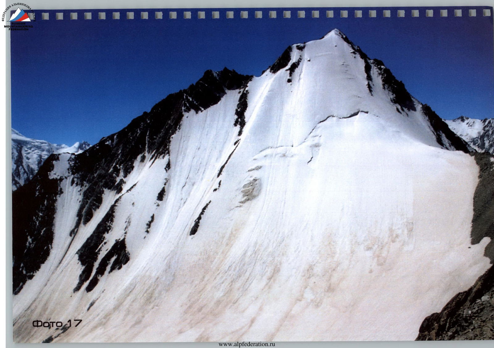
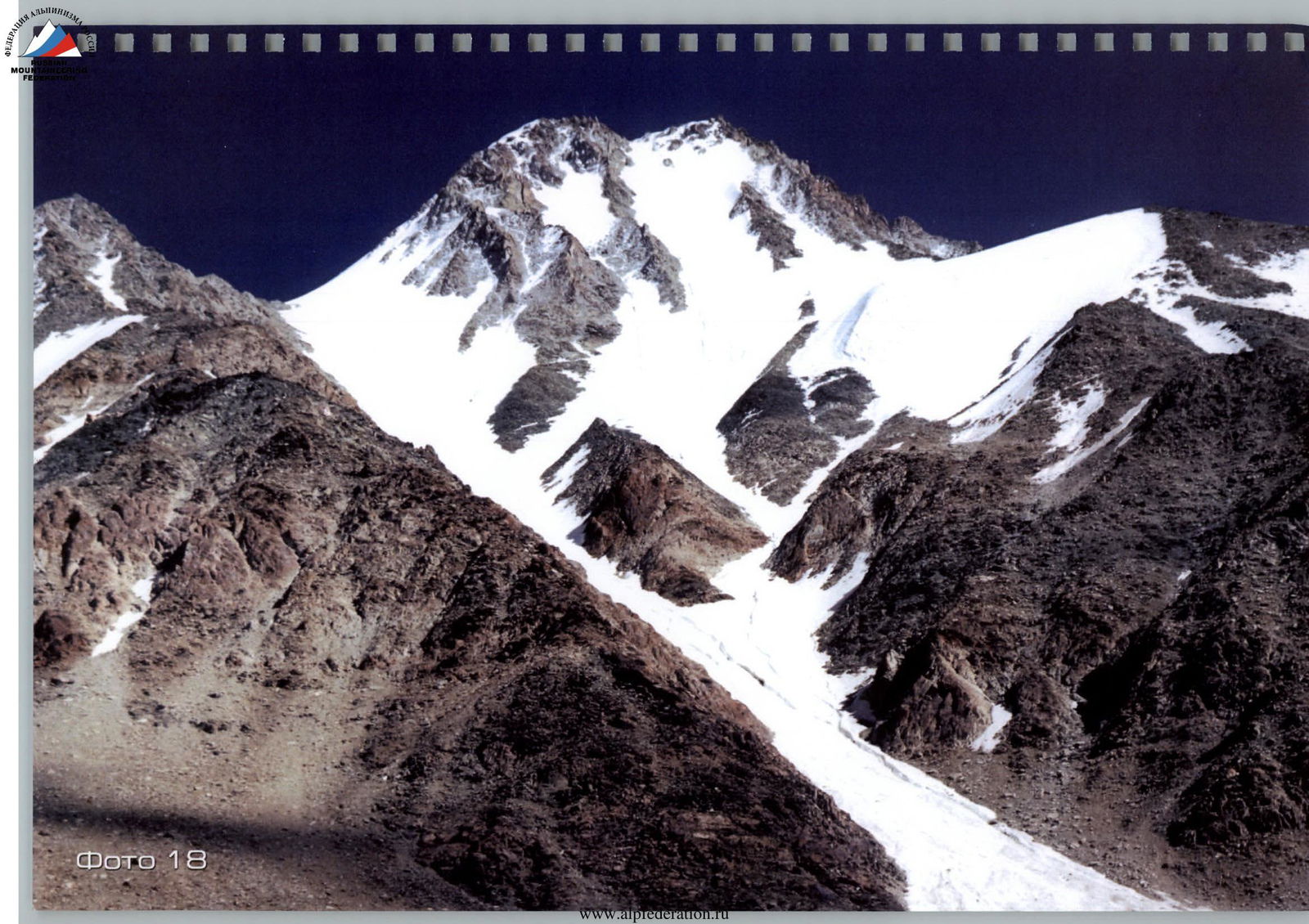
Photo 19
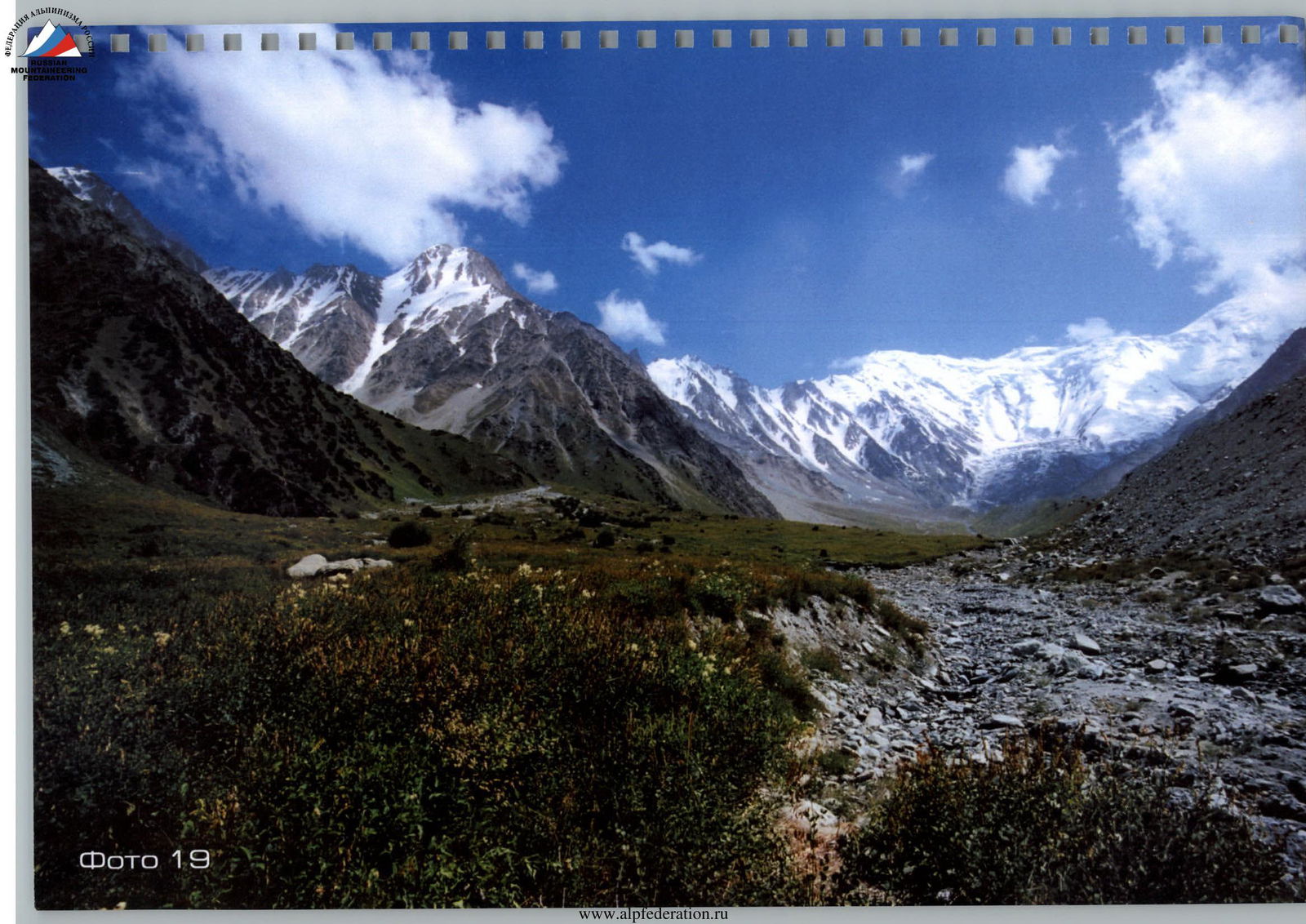
Photo 19
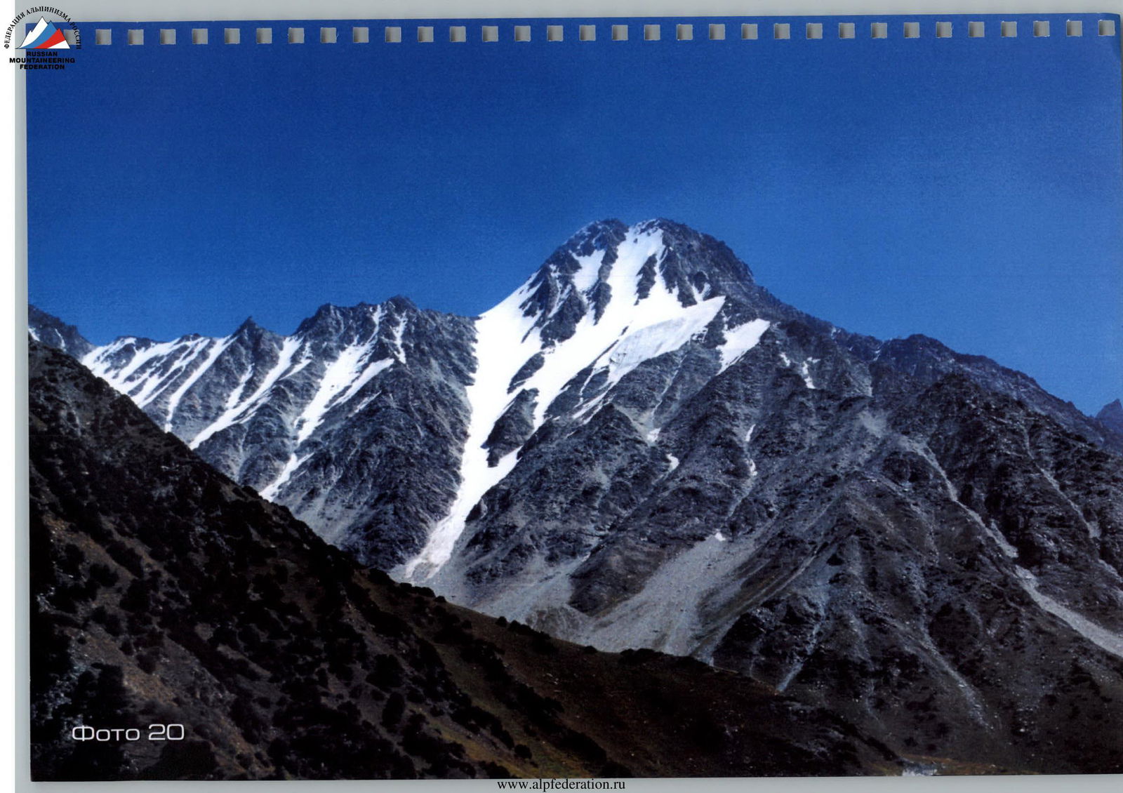
Photo 20
Photo 21
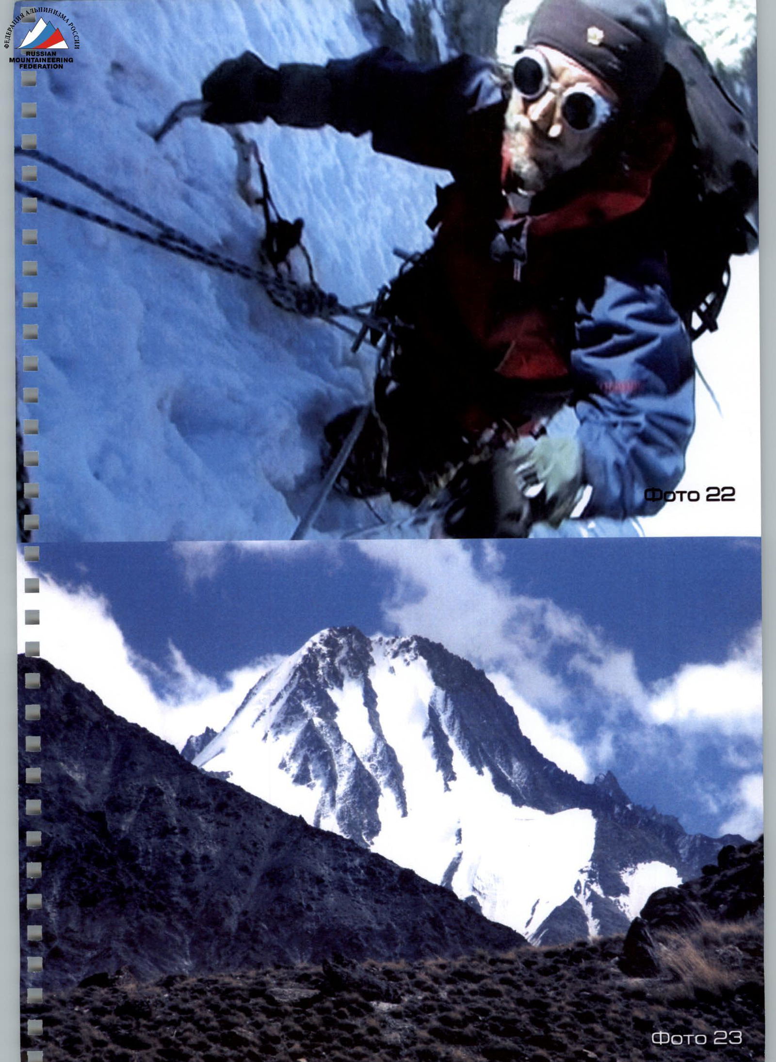
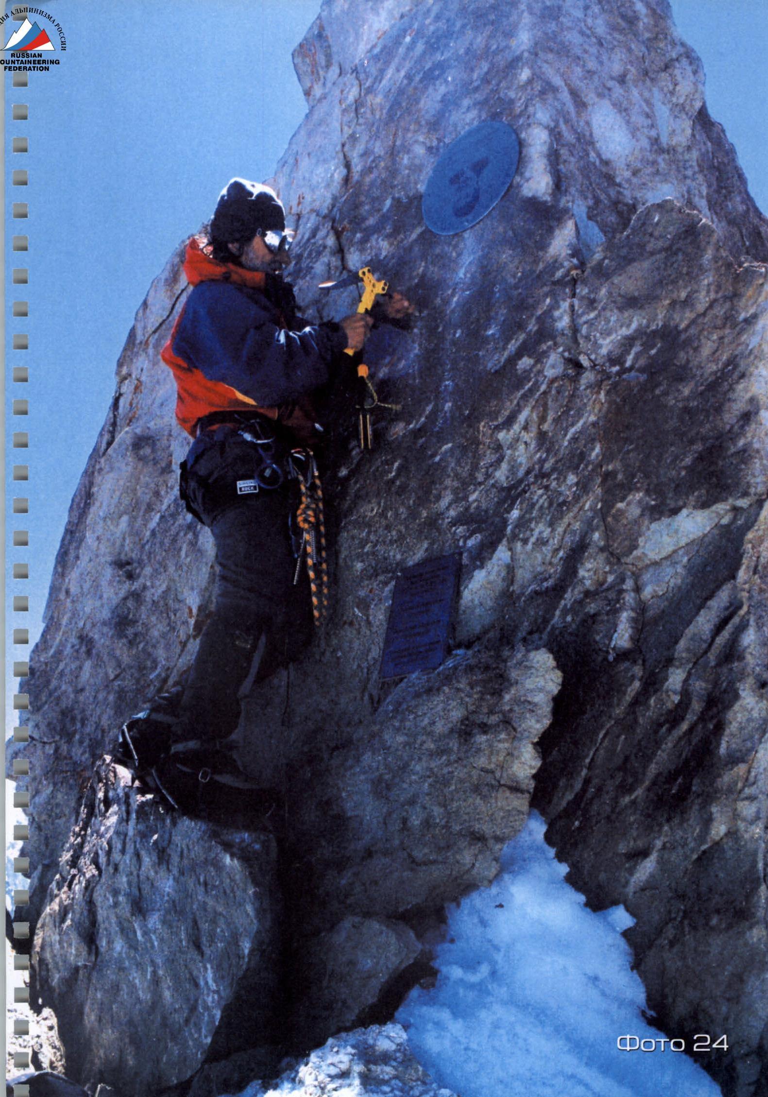
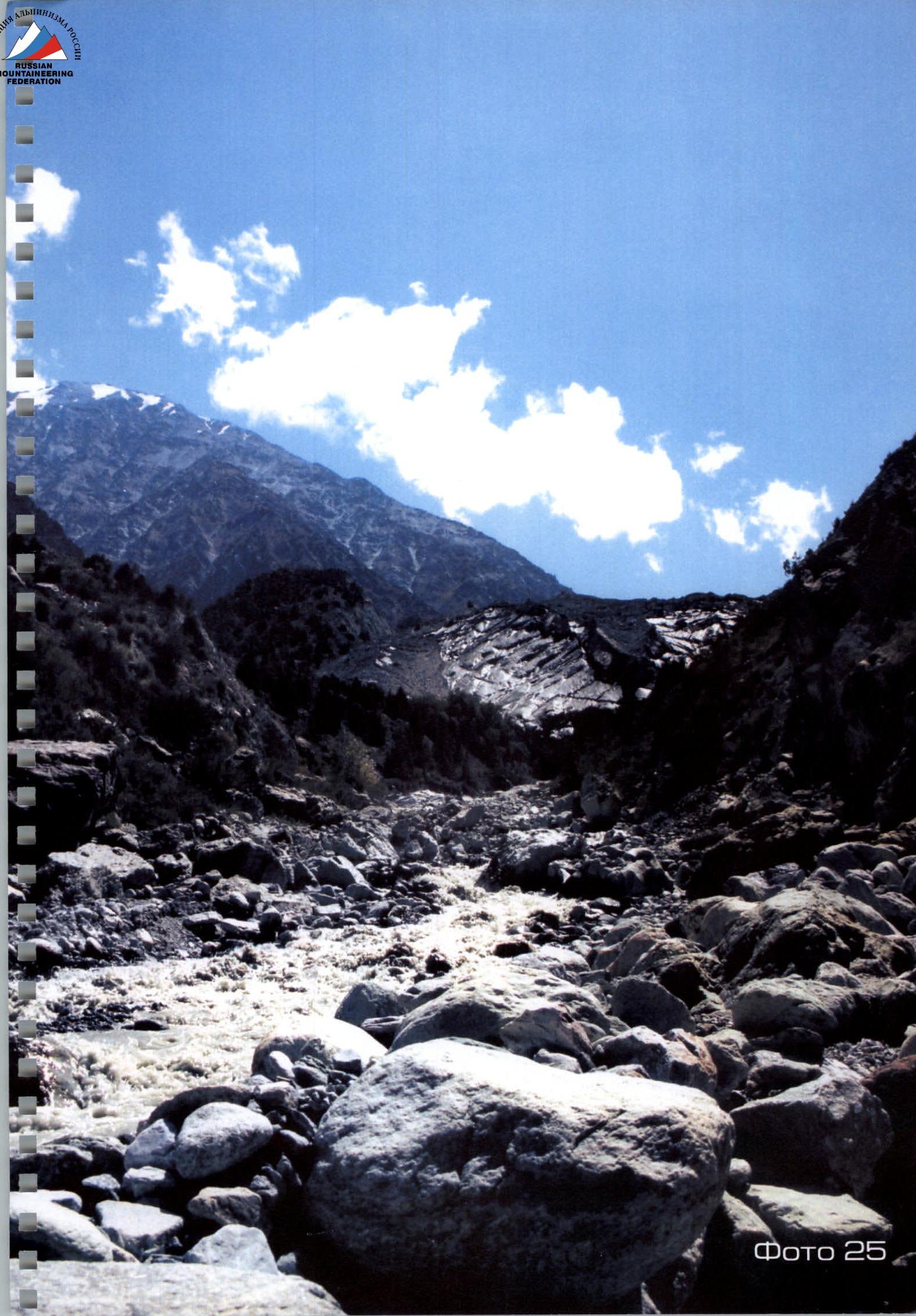
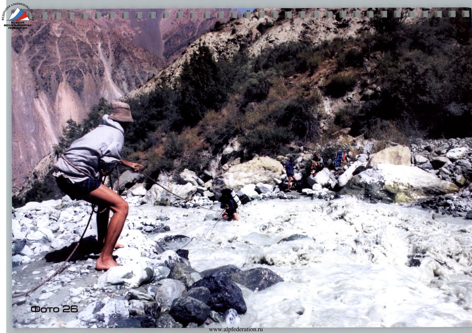
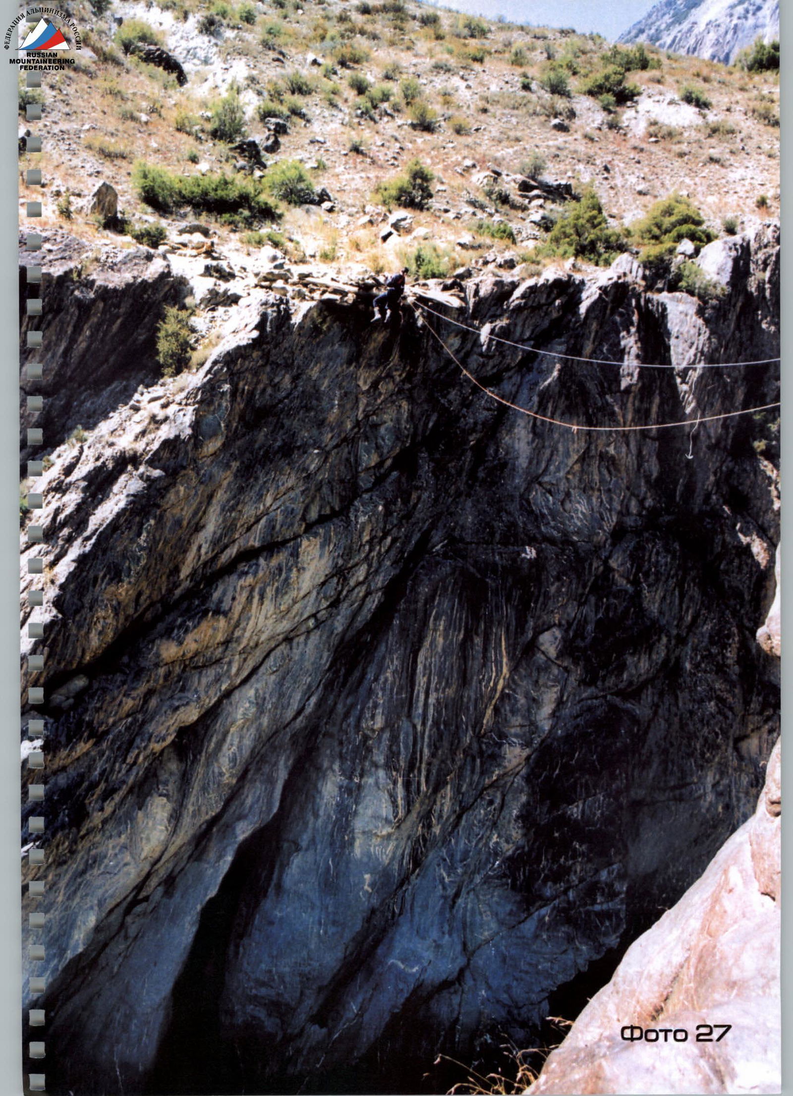
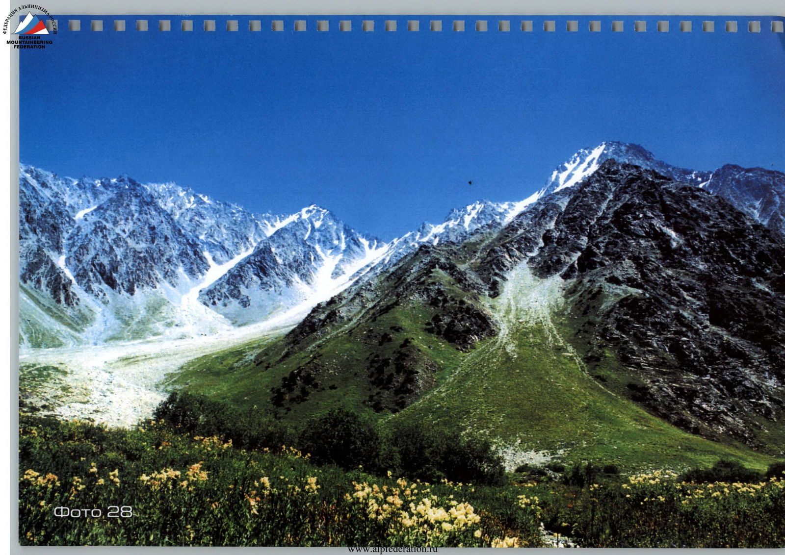
Photo 28
List of photos:
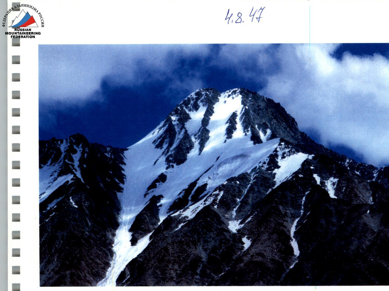
- Photo 1. Peak Oleg Mkrtchan. North slope. View from the side of the Khadyrsha River;
- Photo 2. Peak Oleg Mkrtchan. North-Eastern ridge. View from the side of the "Kurayshapak" pass;
- Photo 3. Profile of the "Peak Oleg Mkrtchan" summit. On the left is the "Kurayshapak" pass. In the background, Peak Korzhenevskaya rises;
- Photo 4. Summit "Peak Oleg Mkrtchan" (height 4980 m);
- Photo 5. Sergey Kaifadzhyan and Anatoly Sharipov at the foot of "Peak Oleg Mkrtchan" before the first ascent on August 25, 2003;
- Photo 6. Sergey Kaifadzhyan during the ascent to Peak Oleg Mkrtchan along the North-Eastern ridge;
- Photo 7. Sergey Kaifadzhyan at the summit of "Peak Oleg Mkrtchan" on August 26, 2003, with the flag of the "Industrial Union of Donbass" corporation — the patron of the first ascent and the program: "Flags of Ukraine, Armenia, and the 'Industrial Union of Donbass' corporation on the world's peaks and in hard-to-reach places on the planet";
- Photo 8. Sergey Kaifadzhyan at the summit of "Peak Oleg Mkrtchan" on August 14, 2004, during the repeat ascent with the "Christian Faith" flag next to the installed memorial signs;
- Photo 9. Anatoly Sharipov at the summit of "Peak Oleg Mkrtchan" on August 14, 2004 (in the background are the mountains of Kyrgyzstan, the Trans-Alay ridge);
- Photo 10. View from the summit of "Peak Oleg Mkrtchan" to the Trans-Alay ridge. Below on the stone, a cairn is installed with a note about the first ascent;
- Photo 11. Peak Korzhenevskaya. Photo from the summit of "Peak Oleg Mkrtchan";
- Photo 12. "Ryży" pass. View from the summit of "Peak Oleg Mkrtchan";
- Photo 13. Peak Korzhenevskaya. Photo from the summit of "Peak Oleg Mkrtchan";
- Photo 14. "Tanasza" pass. Stone window with a view of Peak Oleg Mkrtchan;
- Photo 15. Memorial sign (diameter 35 cm) installed at the summit on August 14, 2004, with an image of the patron — General Director of the "Industrial Union of Donbass" corporation Oleg Mkrtchan;
- Photo 16. Memorial plaque with the names of the first ascenders;
- Photo 17. Summit "Peak Oleg Mkrtchan", North-Eastern ridge, along which the first ascent was made;
- Photo 18. Peak Oleg Mkrtchan symbolizes the letter "M" in shape;
- Photo 19. View from the Khadyrsha meadow. On the left is Peak Oleg Mkrtchan, in the center is Peak Ukraine, on the right is Peak Armenia;
- Photo 20. Peak Oleg Mkrtchan, view from the Khadyrsha meadow;
- Photo 21. Flag of the "Industrial Union of Donbass" corporation against the background of Peak Oleg Mkrtchan in the base camp at an altitude of 3000 m. Khadyrsha meadow;
- Photo 22. Sergey Kaifadzhyan on the ice wall of Peak Oleg Mkrtchan, ascent angle 70°;
- Photo 23. Peak Oleg Mkrtchan. Photo from the north side;
- Photo 24. Installation of a memorial sign at the summit of Peak Oleg Mkrtchan;
- Photo 25. Khadyrsha glacier;
- Photo 26. Crossing the waters of the Khadyrsha glacier;
- Photo 27. Crossing along a metal cable over the Muksu River;
- Photo 28. Peak Oleg Mkrtchan from the west.
On the first cover: Peak Oleg Mkrtchan (height 4980 m), view from the "Kurayshapak" pass. On the last cover: "Christian Faith" flag in the hands of the first ascender Sergey Kaifadzhyan against the background of Peak Oleg Mkrtchan.
Author and first ascender, Sergey Kaifadzhyan, 2005, Ukraine.