USSR Alpine Climbing Championship
High-altitude technical class.
Report
on the ascent of the Moscow City Sports Committee team to Peak Leningradskaya Western (6470) via the Southwest wall from Lipsky Glacier, approximately category 6 difficulty.
Moscow
1981
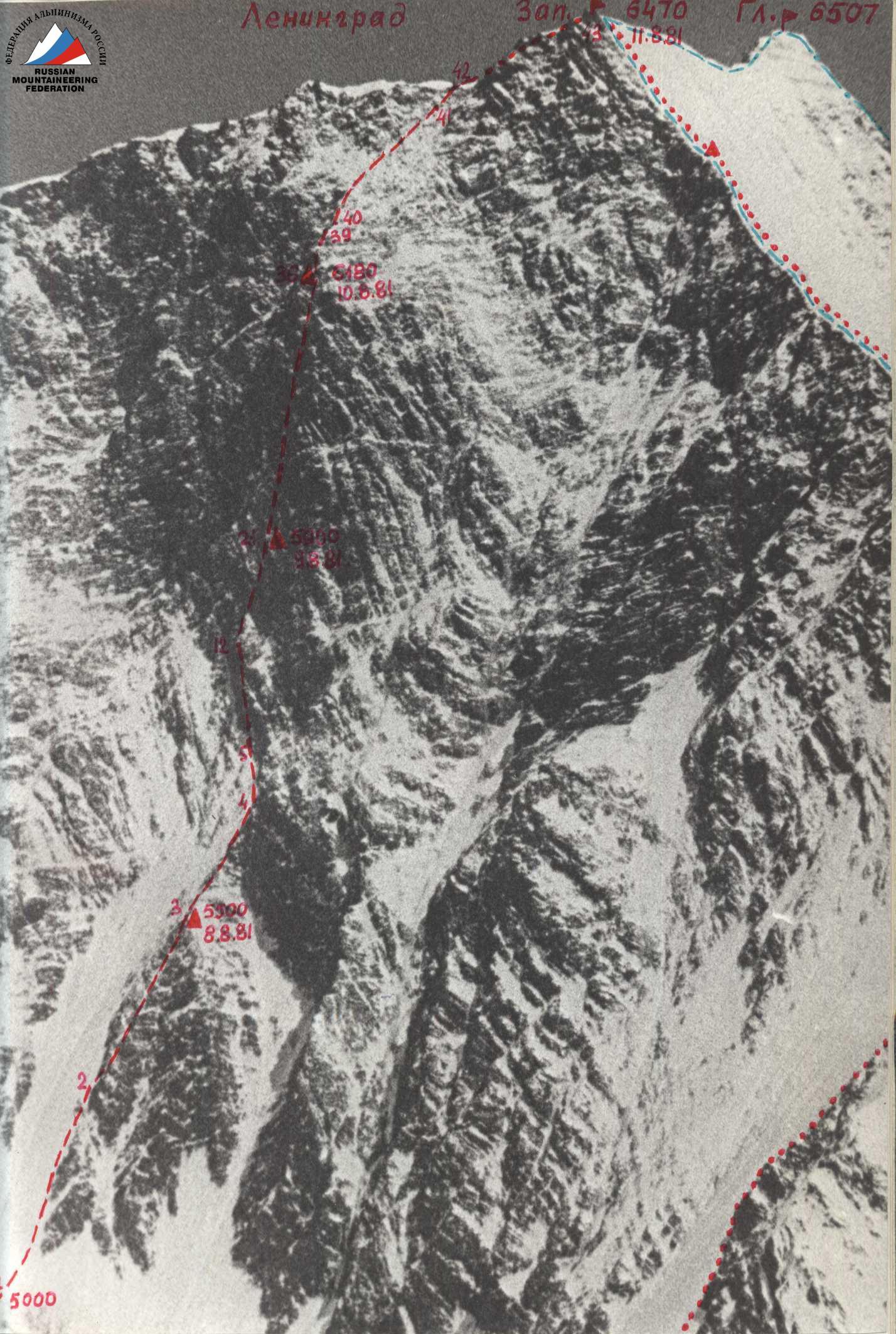
Photo of the wall
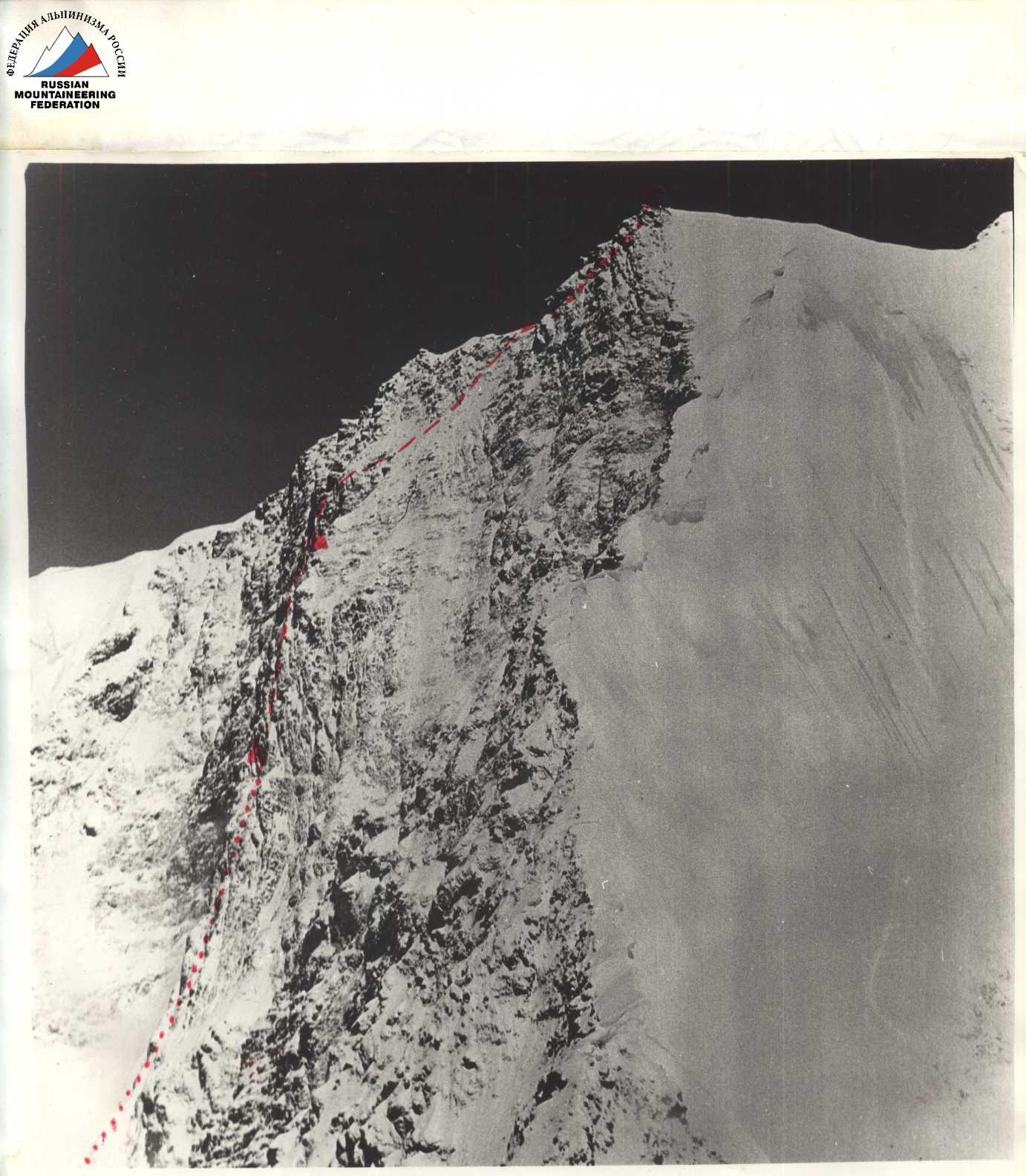
Photo of the route profile.
Taken in winter from a helicopter.
Route Passport
The imposing Southwest wall of Peak Leningradskaya attracted the attention of Moscow climbers about 5 years ago. During a helicopter overflight in December 1976, V. Bozhukov photographed it from various angles. Reviewing these photos, we were convinced that the proposed route, passing through the wall to the left of its concave part - the "trough", was logical and difficult. The route is combined: the lower part of the wall is icy, the upper part is rocky, and the steepness of the route constantly increases, with the rocky part being practically sheer. The route was preliminarily planned in the fall of 1980 and was approved at a coaching council meeting in Moscow along with a list of candidates for the team and training plans.
On August 4, 1981, during a flight from Fortambek Glacier to Vanch-Dara, four team members (Kolomyitsev, Grebenshchikov, Khomutov, Chochia) reviewed and photographed the wall again. The condition of the wall seemed satisfactory to us, but our scouts - the remaining two team members, Puchkov and Elagin, who conducted a reconnaissance on August 2-4 under the wall, provided more detailed information.
- The wall makes a very impressive impression.
- The proposed route is in good condition: there is no avalanche or rockfall danger.
- The approach to the route via Garmo, Belyaeva, and Lipsky glaciers is very challenging, with an elevation gain of over a kilometer. It is better to plan a 2-day approach.
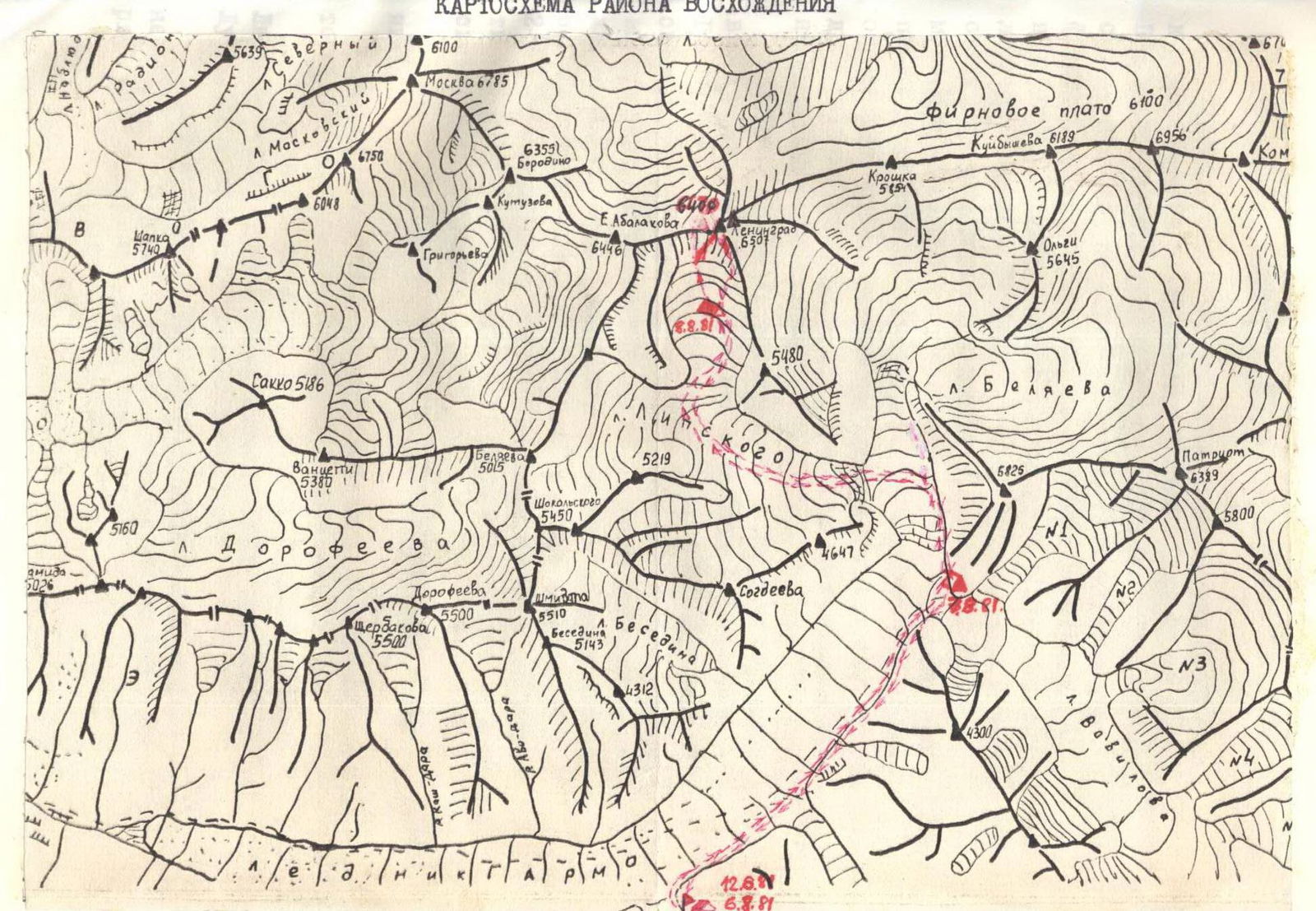
After a brief discussion, we set the departure date for the route as August 8, 1981, and the exit from the base camp in Vanch-Dara as August 6, 1981. The path from the base camp to the Southwest wall of Peak Leningradskaya passes through three glaciers and involves an elevation change of about 1300 m:
- Garmo
- Belyaeva
- Lipsky
From Vanch-Dara to the overnight camps on "Surka", we proceed along the left (orographically) side of the Garmo Glacier and then along the Belyaeva Glacier (on the same side) - exiting into the middle, calm part of the glacier opposite the confluence of Lipsky Glacier. Here, we need to turn left onto Lipsky Glacier and ascend along the middle part of the first step of the glacier.
Then, the glacier turns right, its steepness and fragmentation increase sharply (second step). This step is traversed along the left part (in the direction of travel). At this point, it is necessary to be very cautious:
- A huge hanging glacier is above on the left (!)
- Closed crevices and fragile ice bridges are underfoot
After overcoming the second step, we move along the flat plateau to the right in the direction of Peak Leningradskaya. The Southwest wall is approached by the rightmost tongue of Lipsky Glacier (when viewed from below). To reach its upper plateau, we need to traverse the third step of the glacier, which is located on the left (orographically) side. Movement requires great caution:
- Deep crevices with fragile ice bridges
- Avalanches and rockfalls can occur from the slopes of the South ridge of Peak Leningradskaya
The height of the upper plateau of Lipsky Glacier is about 5000 m.
The approach to the route was quite lengthy (about 14 hours) and required good physical preparation from the team members, observers, and Championship judge V. Smith.
Observation Group Composition
The team was observed on the first day (August 8, 1981) by:
- S. Kerbi
- V. Smith
From August 9, 1981, to August 12, 1981, they were observed by:
- V. Nevedrov, 1st category - senior
- A. Popov, 1st category
Organization and Tactics of the Ascent
When planning the preparation and execution of the ascent via the Southwest wall of Peak Leningradskaya, the team had to solve several complex organizational tasks in the summer season of 1981 due to the team members' participation in three different events:
- Puchkov and Khomutov - participated in the Himalayan gathering
- Kolomyitsev, Grebenshchikov, and Chochia - worked as coaches at the "Pamir-81" Alpine Camp
- Elagin - was at a gathering of the Moscow City Council of the "Burevestnik" Sports Society on the Pamir
By the time of the main ascent, all participants were in excellent physical condition and had sufficient acclimatization.
On August 2-4, 1981, Puchkov and Elagin conducted a reconnaissance under the wall to clarify the approach and observe the wall's condition. Four team members (Kolomyitsev, Grebenshchikov, Khomutov, and Chochia) were airlifted by helicopter from Fortambek to Vanch-Dara on August 4. During the flight over the plateau, they reviewed and photographed the wall again.
In the evening of August 4, the entire team and rescue team gathered in Vanch-Dara. The route was finalized, a tactical plan for the ascent was developed, and equipment and supplies were selected. The exit from the base camp was scheduled for August 6, and the start of the ascent for August 8, 1981.
Team Composition:
- Kolomyitsev V.T. - leader
- Grebenshchikov I.E. - deputy leader
- Puchkov V.N.
- Khomutov V.V.
- Elagin V.I.
- Chochia P.A.
The movement plan was as follows:
- Day 1 (August 8, 1981) - Departure to the route, traversal of the bergschrund, ice slope, and counterfort to camp №1 (5400 m).
- Day 2 (August 9, 1981): Traversing the remaining part of the counterfort, approaching the sheer rocky wall (camp №2, 5700 m).
- Day 3 (August 10, 1981): Processing the lower part of the wall. If a suitable platform is not found, then overnight stay at the previous location (camp №2, 5700 m).
- Day 4 (August 11, 1981): Traversing approximately half of the wall. Overnight stay on a ledge (possibly a seated bivouac) (camp №3, 6000 m).
- Day 5 (August 12, 1981): Traversing the remaining part of the wall, the "roof", exiting onto the ridge and reaching the Western summit of Leningradskaya. Overnight stay in the vicinity of the summit or on the ridge (camp №4, 6470 m).
- Day 6 (August 13, 1981) - Descent along the South ridge to Lipsky Glacier (category 5B difficulty).
- Days 7-8 (August 14-15, 1981) - Reserve days for bad weather.
Alternative descent plan: In case of poor conditions on the South ridge, a descent via the 5A category route through the plateau to Lipsky and then to Fortambek Glacier was planned.
Radio Communication
Radio communication was planned to be conducted using "Karat-M" radios with observers and the base camp three times a day. The base camp in Vanch-Dara would link with the "Pamir-81" Alpine Camp in Achik-Tash using the same radio. Valera Khomutov was responsible for all radio communications.
Equipment
It was decided to take 4 imported 50-meter ropes (the fourth for processing and for safety during climbing on fixed ropes).
For traversing the icy part of the wall, everyone had good modern crampons and ice axes; additionally, the following were taken:
- Ice screws
- Titanium pitons
- Ice hammer
- Ice hook type "fi-fi" (American style)
- Jumars
For overcoming the rocky part, the following were taken:
- Two metal hammers
- Set of titanium pitons of various profiles
- Complete set of chocks
- Three two-stage ladders
- Extension loops
- Light carabiners
- Drill bits
- Drill pitons
- Absorber for the first climber
For overnight stays, a lightweight high-altitude tent, carimats, and down suits were taken for everyone.
For the descent, everyone had "figure-eight" descenders.
Vasya Elagin was responsible for the equipment.
Provisions
Provisions for the ascent were selected by Pasha Chochia and Volodya Puchkov, calculating approximately 400 g per person per day. High-calorie and lightweight products were chosen. Here is their approximate list:
- Bacon
- Cured sausage
- Cheese
- Crackers
- Honey
- Sugar
- Candies
- Chocolate
- Freeze-dried soups
- Cottage cheese
- Juices
- Prunes
- Raisins
- Figs
- Tea
- Coffee
- Lemons
Tactics of Movement
The rope teams were distributed as follows:
- Kolomyitsev - Chochia
- Elagin - Grebenshchikov
- Puchkov - Khomutov
It was decided to give all three teams the opportunity to work as leaders, to work independently on simpler sections, and on more complex ones, to have everyone except the first, who goes with a lightened backpack, climb on jumars along fixed ropes (backpack on the back or between the legs - American style), обязательно with upper belay.
Route Description
(explanation to table №1) From the bivouac on the upper plateau of Lipsky Glacier, the approach is made along the snow to the base of the icy part of the wall, to the left of the destroyed rocky counterfort.
The route begins with overcoming the bergschrund with a 5-meter sheer ice wall (R0–R1). Further movement is along the right part of the steep ice slope (R1–R2) towards the rocky counterfort and under the cover of its rocks upwards.
Approximately from 11:00, rocks start falling from the wall onto the ice, so it is necessary to traverse the steep, heavily destroyed counterfort, partially covered with ice (R2–R3). The length of this section is about 300 m.
At the top of the counterfort to the right, there is a scree slope, on which:
- a relatively safe bivouac is possible,
- a platform is laid out from stones,
- the overnight stay is semi-reclined,
- the height is about 5500 m (camp №1).
Further, the counterfort turns into a steep rocky ridge (R3–R4) about 150 m long. From the upper part of the ridge, there is an exit to the left along steep ice to the base of the sheer rocky wall.
The Southwest wall to the left of the concave part with snow - the "trough" - is an approximately 500-meter, almost sheer wall, divided into two parts by a narrow groove.
The left part of the wall consists of gray, destroyed rocks, the right part - of red, more monolithic rocks.
Our route is planned along the right part of the wall, but it is not advisable to be under it after 11:00-12:00 due to falling rocks from above the "roof".
The exit from the ice to the wall is via an 8-meter internal corner with an overhanging plug (R5–R6). Further along a sloping scree ledge to the left (R6–R7) to the base of a steep 10-meter chimney filled with ice (R7–R8). Then along a difficult 30-meter wall (R8–R9) upwards - exit to a sloping scree ledge (R9–R10).
Along the ledge to the left - upwards to a 10-meter crack (R10–R11). After the crack - a sheer monolithic wall with ice (R11–R12, 20 m). Climbing is very complex in the direction of an internal corner (R12–R13, 10 m).
After the internal corner - exit to a small ledge and from it along a difficult 50-meter wall (R13–R14) upwards and slightly to the left to the base of an 8-meter internal corner with a cornice (R14–R15) ("live" stones!).
Then along a sheer monolithic 10-meter wall (R15–R16) (chocks, ladders) - exit to the right onto a smooth inclined slab with snow and ice (R16–R17). Along the slab to the right under a large overhang and along a sheer 7-meter slab-detached rock (R17–R18) - straight upwards.
Further along hanging large blocks (some "live"!) - very difficult climbing using chocks and ladders upwards-to the left in the direction of bypassing a large overhang (R18–R19). The large cornice is bypassed on the left along very difficult rocks (R19–R20, 30 m) and further along a 30-meter wall (R20–R21) - exit to narrow ledges under hanging rocks.
Seated overnight stay. Height about 5900 m (camp №2).
From the overnight stay to the right and then upwards along rocks filled with ice (R21–R22, 20 m), further along the right edge of a 15-meter wet internal corner towards a snow patch (R22–R23). From the ledge with a snow patch, a traverse along a 10-meter inclined slab (R23–R24) under a large rock in the shape of a "hump", then along a monolithic steep 20-meter slab upwards (R24–R25) and a 10-meter wall to the right - upwards (R25–R26) to the base of an overhanging internal corner (R26–R27).
Very difficult internal corner passes to the left of the "hump" rock and is traversed: first along its right side (7 m), then to the left - upwards (10 m), and a traverse to the right (5 m) to a crack with ice, continuing the internal corner (R27–R28, 10 m).
Climbing is very tense with the use of artificial holds. Further, the route passes to the left - upwards along difficult destroyed rocks (R28–R29, 15 m) under a large hanging "red" cornice. Under the wall, there are long narrow scree ledges (seated overnight stay is possible). In the middle part of the ledges, an ascent to the left - upwards along a complex monolithic wall with an overhang (R29–R30, 15 m). Movement is always under the large "red" cornice, which needs to be bypassed on the left.
After the wall with an overhang:
- a traverse to the left along difficult rocks (R30–R31, 10 m)
- then an ascent 25 m upwards (R31–R32) to a small scree ledge above the cornice.
From the ledge slightly to the left-down - entry into a sheer 40-meter internal corner with smooth walls and a large overhanging plug in the middle (R32–R33). Climbing is extremely difficult with the use of all technical means.
After the internal corner:
- to the right-upwards on a 10-meter scree ledge (R33–R34) - exit to two characteristic 3-meter detached rocks at the wall.
On the scree ledge at the detached rocks, a control cairn is built. From the ledge along steep tile-like rocks 50 m of difficult climbing straight upwards (R34–R35) to the exit onto a wide inclined ledge leading to the left-upwards under a large hanging rock against the sky (R35–R36, 50 m). On the ledge under the overhang - seated overnight stay. Height approximately 6200 m (camp №3).
The hanging rock is bypassed on the left along difficult, highly dissected rocks (R36–R37, 50 m). This section has overhanging sections and large "live" blocks. Then another 40 m to the right-upwards along a destroyed internal corner (R37–R38) to the exit onto the rocky ridge, which is the left edge of the "trough". Along rocks of medium difficulty 40 m to the left-upwards (R38–R39) to a sharp snow ridge. Here, the wall part of the route ends, and the "roof" begins. Nearby to the left, a groove descends, dividing the wall into two parts.
Further, the route passes along a snow 10-meter sharp ridge (cornices!) (R39–R40), then:
- to the right-upwards along steep ice with a thick layer of soggy snow and sections of smooth rocks (R40–R41);
- belay via rocky and ice screws;
- movement on the front points of crampons.
The "roof" ends with a string of heavily destroyed, snow-covered, icy rocks (R41–R42), leading to a snow mulde on the pre-summit ridge before the final ascent to the summit. The ascent to the Western summit of Leningradskaya is along a steep snow slope (R42–R43, 150 m). On the highest rocks of the summit, a control cairn is built, and a note is left.
Descent along the South ridge (very loose snow, large cornices!) and from it to the right onto Lipsky Glacier, first along a snow counterfort, then along destroyed rocks, and finally along a 300-meter steep ice slope (descent on ropes, the last one with lower hook belay on the front points of crampons).
Main Characteristics of the Route:
Descent along the South ridge (very loose snow, large cornices!), transition to the right onto Lipsky Glacier, movement along a snow counterfort, traversal of destroyed rocks, overcoming a 300-meter steep ice slope - descent on ropes, the last section with lower hook belay on the front points of crampons.
Table of Main Route Characteristics
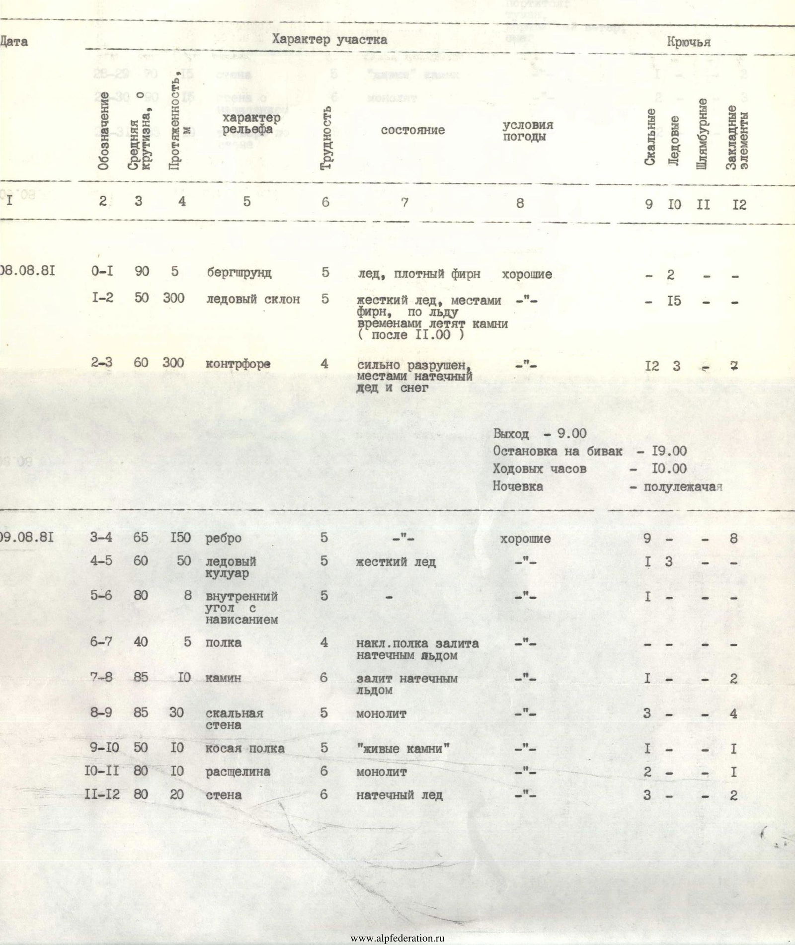
| Date | Designation | Average Steepness, ° | Length, m | Relief Character | Difficulty | Condition | Weather Conditions | Rock Pitons | Ice Pitons | Drill Pitons | Chocks |
|---|---|---|---|---|---|---|---|---|---|---|---|
| August 8, 1981 | R0–R1 | 90 | 5 | Bergschrund | 5 | Ice, dense firn | Good | — | 2 | — | — |
| R1–R2 | 50 | 300 | Ice slope | 5 | Hard ice, partially firn, rocks falling from above (after 11:00) | —"— | — | 15 | — | — | |
| R2–R3 | 60 | 300 | Counterfort | 4 | Heavily destroyed, partially ice and snow | —"— | 12 | 3 | — | 2 | |
| Exit - 9:00 | |||||||||||
| Stop for bivouac - 19:00 | |||||||||||
| Climbing hours - 10:00 | |||||||||||
| Overnight stay - semi-reclined | |||||||||||
| August 9, 1981 | R3–R4 | 65 | 150 | Ridge | 5 | —"— | Good | 9 | — | — | 8 |
| R4–R5 | 60 | 50 | Ice couloir | 5 | Hard ice | —"— | 1 | 3 | — | — | |
| R5–R6 | 80 | 8 | Internal corner with overhang | 5 | —"— | —"— | 1 | — | — | — | |
| R6–R7 | 40 | 5 | Ledge | 4 | Inclined ledge filled with ice | —"— | 1 | — | — | — | |
| R7–R8 | 85 | 10 | Chimney | 6 | Filled with ice | —"— | 1 | — | — | 2 | |
| R8–R9 | 85 | 30 | Rocky wall | 5 | Monolithic | —"— | 3 | — | — | 4 | |
| R9–R10 | 50 | 10 | Sloping ledge | 5 | "Live" stones | —"— | 1 | — | — | 1 | |
| R10–R11 | 80 | 10 | Crack | 6 | Monolithic | —"— | 2 | — | — | 1 | |
| R11–R12 | 80 | 20 | Wall | 6 | Ice | —"— | 3 | — | — | 2 |
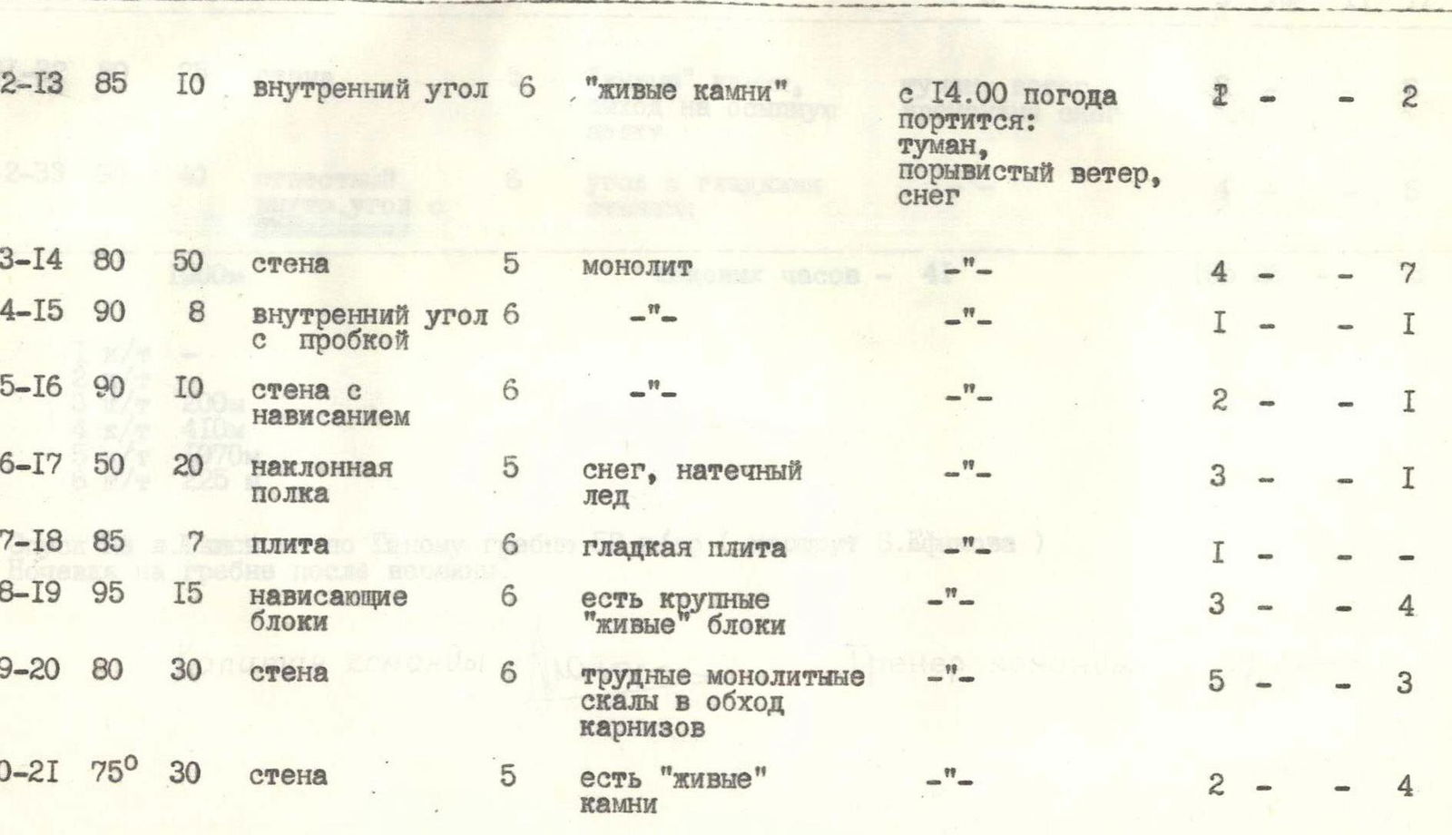
| Date | Designation | Average Steepness, ° | Length, m | Relief Character | Difficulty | Condition | Weather Conditions | Rock Pitons | Ice Pitons | Drill Pitons | Chocks |
|---|---|---|---|---|---|---|---|---|---|---|---|
| August 10, 1981 | R12–R13 | 85 | 10 | Internal corner | 6 | "Live" stones | From 14:00 weather deteriorates: fog, gusty wind, snow | — | 2 | — | 2 |
| R13–R14 | 80 | 50 | Wall | 5 | Monolithic | —"— | 4 | — | — | 7 | |
| R14–R15 | 90 | 8 | Internal corner with plug | 6 | —"— | —"— | 1 | — | — | 1 | |
| R15–R16 | 90 | 10 | Wall with overhang | 6 | —"— | —"— | 2 | — | — | 1 | |
| R16–R17 | 50 | 20 | Inclined ledge | 5 | Snow, ice | —"— | 3 | — | — | 1 | |
| R17–R18 | 85 | 7 | Slab | 6 | Smooth slab | —"— | 1 | — | — | — | |
| R18–R19 | 95 | 15 | Hanging blocks | 6 | Large "live" blocks present | —"— | 3 | — | — | 4 | |
| R19–R20 | 80 | 30 | Wall | 6 | Difficult monolithic rocks bypassing cornices | —"— | 5 | — | — | 3 | |
| R20–R21 | 75 | 30 | Wall | 5 | "Live" stones present | —"— | 2 | — | — | 4 | |
| Exit - 8:00 | |||||||||||
| Stop for bivouac - 20:00 | |||||||||||
| Climbing hours - 12 | |||||||||||
| Overnight stay on ledges under overhang - seated (100 m of wall processed this day) | |||||||||||
| R21–R22 | 80 | 20 | Wall | 5 | Ice | Fog, wind, occasional snow | 4 | — | — | — | |
| R22–R23 | 85 | 15 | Internal corner with overhang | 5 | Wet internal corner | —"— | 3 | — | — | 2 | |
| R23–R24 | 40 | 10 | Inclined slab | 4 | Traverse along wet slab with snow | —"— | 3 | — | — | — | |
| R24–R25 | 80 | 20 | Slab | 5 | Monolithic | —"— | 3 | — | — | 1 | |
| R25–R26 | 70 | 10 | Wall | 5 | —"— | —"— | 1 | — | — | 1 | |
| R26–R27 | 90 | 25 | Chimney | 6 | Wet chimney | —"— | 3 | — | — | 5 | |
| R27–R28 | 80 | 10 | Crack | 6 | Ice | —"— | 2 | — | — | 1 | |
| R28–R29 | 70 | 15 | Wall | 5 | "Live" stones | —"— | 1 | — | — | 2 | |
| R29–R30 | 90 | 15 | Wall with overhang | 6 | Monolithic | —"— | 2 | — | — | 3 | |
| R30–R31 | 85 | 10 | Traverse along wall | 6 | —"— | —"— | 2 | — | — | — |
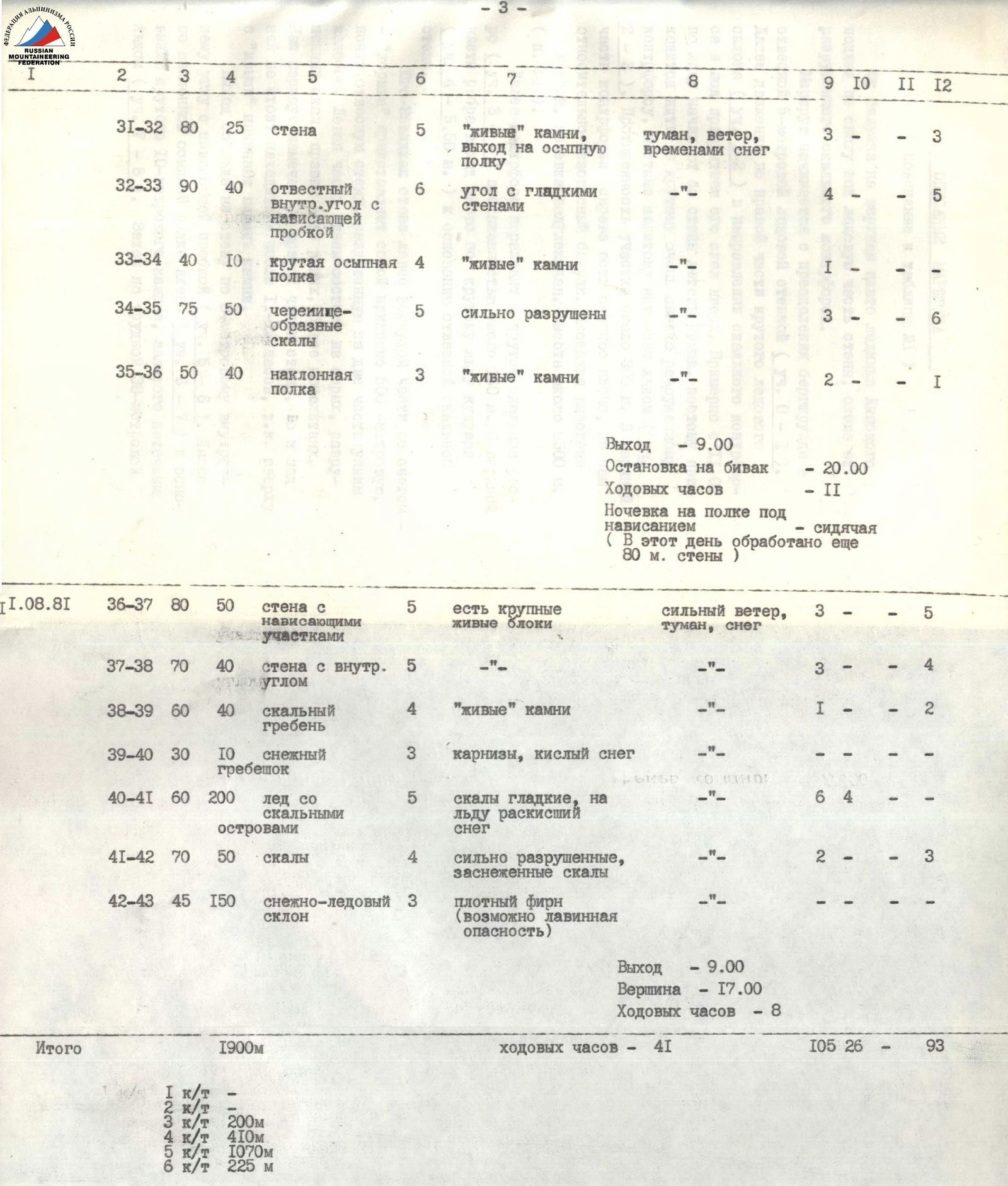
| Date | Designation | Average Steepness, ° | Length, m | Relief Character | Difficulty | Condition | Weather Conditions | Rock Pitons | Ice Pitons | Drill Pitons | Chocks |
|---|---|---|---|---|---|---|---|---|---|---|---|
| August 11, 1981 | R31–R32 | 80 | 25 | Wall | 5 | "Live" stones, exit to scree ledge | Fog, wind, occasional snow | 3 | — | — | 3 |
| R32–R33 | 90 | 40 | Sheer internal corner with overhanging plug | 6 | Corner with smooth walls | —"— | 4 | — | — | 5 | |
| R33–R34 | 40 | 10 | Steep scree ledge | 4 | "Live" stones | —"— | 1 | — | — | — | |
| R34–R35 | 75 | 50 | Tile-like rocks | 5 | Heavily destroyed | —"— | 3 | — | — | 6 | |
| R35–R36 | 50 | 40 | Inclined ledge | 3 | "Live" stones | —"— | 2 | — | — | 1 | |
| Exit - 9:00 | |||||||||||
| Stop for bivouac - 20:00 | |||||||||||
| Climbing hours - 11 | |||||||||||
| Overnight stay on ledge under overhang - seated (80 m of wall processed this day) | |||||||||||
| R36–R37 | 80 | 50 | Wall with overhanging sections | 5 | Large "live" blocks present | Strong wind, fog, snow | 3 | — | — | 5 | |
| R37–R38 | 70 | 40 | Wall with internal corner | 5 | —"— | —"— | 3 | — | — | 4 | |
| R38–R39 | 60 | 40 | Rocky ridge | 4 | "Live" stones | —"— | 1 | — | — | 2 | |
| R39–R40 | 30 | 10 | Snow ridge | 3 | Cornices, sour snow | —"— | — | — | — | — | |
| R40–R41 | 60 | 200 | Ice with rocky outcrops | 5 | Smooth rocks, soggy snow on ice | —"— | 6 | 4 | — | — | |
| R41–R42 | 70 | 50 | Rocks | 4 | Heavily destroyed, snow-covered rocks | —"— | 2 | — | — | 3 | |
| R42–R43 | 45 | 150 | Snow-ice slope | 3 | Dense firn (possible avalanche danger) | —"— | — | — | — | — | |
| Exit - 9:00 | |||||||||||
| Summit - 17:00 | |||||||||||
| Climbing hours - 8 | |||||||||||
| Total | 1900 | Climbing hours - 41 | 105 | 26 | — | 93 |
Descent along the South ridge to Lipsky Glacier, category 5B (B. Efimov's route). Overnight stay on the ridge after the summit.
Table 2. Equipment List
| № | Name | Quantity | Approximately on sections | Weight |
|---|---|---|---|---|
| 1. | Main rope (50 m) | 4 | R1–R43 | 14 |
| 2. | Auxiliary rope (20 m) | 1 | R1–R43 | 0.5 |
| 3. | High-altitude tent | 1 | Camp №1, 2, 3 | 4 |
| 4. | "Shmel" stove with 4 liters of gasoline | 1 | Camp №1, 2, 3 | 5 |
| 5. | Rock hammers | 2 | R3–R42 | 1.5 |
| 6. | Ice hammer | 1 | R1, R2, R3, R5, R41 | 1 |
| 7. | Light carabiners | 40 | R1–R43 | 2.8 |
| 8. | Rock pitons | 30 | R3–R42 | 1.5 |
| 9. | Ice screws | 6 | R1, R2, R3, R5, R41 | 0.6 |
| 10. | Chocks | 11 | R3–R42 | 1 |
| 11. | Extension loops | 8 | R1–R42 | 0.5 |
| 12. | Ladders | 3 | R16, R19, R23, R27, R30, R33 | 0.3 |
| 13. | Ice hook "fi-fi" | 1 | R1, R2, R3, R5, R41 | 0.2 |
| 14. | Absorber | 1 | R1–R43 | 0.1 |
| 15. | Drill | 2 | — | 0.2 |
| 16. | Drill pitons | 10 | — | 0.3 |
| 17. | "Karat" radio | 1 | — | 3.5 |
| 18. | Headlamp | 1 | On overnight stays | 0.3 |
| 19. | First aid kit | 1 | — | 1.5 |
| 20. | "Smena" camera | 2 | — |