Table of Main Characteristics of the Ascent Route to Peak Borodino from Fortambek Glacier
| Date | Designation | Average Steepness in Degrees | Length | Relief Character of the Section | Category of Difficulty | Section Condition | Weather | Rock Pits | Ice Pits | Bolt Pits | Note |
|---|---|---|---|---|---|---|---|---|---|---|---|
| July 26, 1979 | R0–R1 | 40° | 200 m | Snow-ice slope and I bergschrund | 4 | Snow-covered ice | good | 1 | Processing | ||
| R1–R2 | 45° | 350 m | Ice slope | 4 | Pure ice | « | 4 | route | |||
| R2–R3 | 90° | 8 m | II bergschrund | 6 | Steep ice | « | 1 | P | |||
| R3–R4 | 50° | 200 m | Ice slope and III bergschrund | 5 | Pure ice | « | 4 | ||||
| R4–R5 | 30° | 130 m | Snow slope | 5 | Deep snow | « | |||||
| Departure at 9:00. Stop at 17:30. Working hours 8 h 30 min. Overnight stay on snow in camp I. | |||||||||||
| July 27, 1979 | R5–R6 | 90° | 15 m | IV bergschrund | 6 | Steep ice | good | 2, P | Processing | ||
| R6–R7 | 60° | 110 m | Ice slope | 5 | Pure ice | « | 12 | route | |||
| R7–R8 | 75° | 40 m | Inner corner | 6 | Smooth, frozen rocks | « | 6, P | ||||
| R8–R9 | 90° | 10 m | Wall | 6 | Smooth slabs | fog | 2, P | ||||
| Departure at 7:00. Stop at 17:00. Working hours 10 h. Descent and overnight stay in camp I. | |||||||||||
| July 28, 1979 | R5–R9 | Passing previously processed section | 5 | Broken rocks | good | 12 | |||||
| R9–R10 | 70° | 70 m | Rock wall | 5 | Broken ledge | « | 3 | ||||
| R10–R11 | 50° | 30 m | Inclined ledge | 6 | Rocks, formed ice | « | 9, 6 | ||||
| R11–R12 | 90° | 50 m | Inner corner | 5 | Frozen rocks | « | 4 | ||||
| R12–R13 | 75° | 20 m | Rock edge | ||||||||
| Departure at 6:00. Stop at 17:00. Working hours 11 h. Descent to overnight stay in base camp. | |||||||||||
| July 29–30 | |||||||||||
| July 31, 1979 | R0–R5 | Passing previously processed sections. | good | ||||||||
| Departure at 9:00. Stop at 15:00. Working hours 6 h. Overnight stay in camp I in tent. | |||||||||||
| August 1, 1979 | R6–R13 | Passing previously processed sections. | good | ||||||||
| R13–R14 | 65° | 60 m | Broken wall | 5 | Snow-covered rocks | « | 8 | ||||
| R14–R15 | 90° | 40 m | Outer corner | 6 | Frozen rocks | « | 5,3 | 2 | |||
| Departure at 6:00. Stop at 19:00. Working hours 12 h. Overnight stay for 6 people sitting on a ledge, 2 people sitting on a ledge. | |||||||||||
| August 2, 1979 | R15–R16 | 76° | 100 m | Slab-like wall | 5 | Smooth slabs | good | 12 | |||
| R16–R17 | 75° | 80 m | Rock edge | 5 | Frozen rocks | « | 14 | ||||
| R17–R18 | 90° | 30 m | Inner corner | 6 | Rocks, formed ice | « | 7,1 | ||||
| Departure at 9:00. Stop at 17:00. Working hours 8 h. Sitting overnight stay. Four people in a sitting tent, four on a ledge. | |||||||||||
| August 3, 1979 | R18–R19 | 60° | 120 m | Slabs | 5 | Frozen slabs | fog, wind | 14 | |||
| R19–R20 | 90° | 25 m | Inner corner | 6 | Steep rocks, ice | « | 5,1 | ||||
| R20–R21 | 70° | 30 m | Wall | 5 | Smooth rocks | « | 8 | ||||
| R21–R22 | 80° | 30 m | Chimney | 6 | Steep rocks, formed ice | « | 7 | ||||
| R22–R23 | 70° | 20 m | Chimney | 5 | Steep rocks | « | 5 | ||||
| R23–R24 | 90° | 10 m | Inner corner | 6 | Rocks, formed ice | « | 2, P | ||||
| R24–R25 | 75° | 50 m | Red wall | 5 | Fragile rocks | « | 10 | ||||
| Departure at 7:00. Stop at 18:00. Working hours 11 h. Sitting overnight stay on a ledge, covered with a tent. | |||||||||||
| August 4, 1979 | R25–R26 | 70° | 20 m | Slabs | 5 | Smooth rocks | bad, wind, snow, blizzard | 6 | Processing route | ||
| R26–R27 | 80° | 20 m | Wall | 6 | Smooth slabs | fog | 6,1 | ||||
| R27–R28 | 75° | 30 m | Smooth slabs | 5 | Snow-covered slabs | « | 8 | ||||
| R28–R29 | 90° | 15 m | Wall | 6 | Smooth wall | « | 3, P | ||||
| R29–R30 | 70° | 10 m | Slab-like rocks | 5 | Snow-covered slabs | « | 4 | ||||
| R30–R31 | 80° | 40 m | Rock edge | 6 | Snow-covered rocks | « | 11 | ||||
| R31–R32 | 20 m | Ledge | 4 | Rock ledge | « | 3 | |||||
| R32–R33 | 75° | 40 m | Wall | 6 | Frozen slabs | « | 6,1 | 1 | |||
| Departure at 10:00. Stop at 18:30. Working hours 8 h 30 min. Descent to camp 4. Sitting overnight stay. | |||||||||||
| August 5, 1979 | R25–R33 | Passing processed sections | bad, snow, wind, fog | - | - | ||||||
| R33–R34 | 90° | 20 m | Rock crevice | 6 | Ice-covered rocks | « | 4,2 | - | |||
| R34–R35 | 80° | 15 m | Wall | 5 | Frozen rocks | « | 2,3 | - | |||
| R35–R36 | 90° | 25 m | Inner corner | 6 | Rocks, formed ice | « | 5,1 | - | |||
| R36–R37 | 50° | 40 m | Snow-ice ridge | 4 | Loose snow | « | - | - | - | ||
| Departure at 9:30. On the summit at 17:00. Working hours 7 h 30 min. | |||||||||||
| Descent to GanDo glacier and stop at the upper stage of the icefall at 20:00. | |||||||||||
| August 6, 1979 | Descent to the base camp of Georgian climbers on GanDo glacier |
Ascent Passport
- Ascent class — high-altitude technical
- Ascent area — Pamir, Peter the First Ridge (4,8)
- Peak, its height, route — peak Borodino (6100 m) from Fortambek glacier
- Expected category of difficulty — 6 cat. diff.
- Route characteristics:
Height difference:
- Rock part of the route — 1100 m
- Snow-ice part of the route — 600 m
- Total height difference of the route — 1700 m Steepness:
- Rock part of the route — 74°
- Snow-ice part of the route — 48° Length:
- Rock part of the route — 1235 m
- Ice-snow part of the route — 888 m
- Total length of the route — 2123 m Length of sections:
- 1 cat. diff. — absent
- 2 cat. diff. — absent
- 3 cat. diff. — 130 m
- 4 cat. diff. — 610 m
- 5 cat. diff. — 950 m
- 6 cat. diff. — 433 m
- Number of driven pits for insurance: of which for creating I.T.O.
Rock: 206 26 Ice: 34 10 Bolt: 3 3 - Number of working hours — 81 hours.
- Number of overnight stays on the route: 7 overnight stays. 3 overnight stays in camp I — lying in tents. 4 overnight stays on the route — sitting.
- F.I.O. of the leader, participants, their sports qualification:
- KOVTUN Vasily Grigorievich, Master of Sports, Kiev — leader
- VERBA Alexander Andreevich, Master of Sports, Kiev — deputy leader
- BALINSKY Anatoly Pavlovich, Master of Sports, Alushta — participant
- BYCHEK Alexander Mikhailovich, Master of Sports, Kiev — participant
- FOMIN Alexander Sergeevich, Master of Sports, Kiev — participant
- VOLKOV Leonid Borisovich, Candidate for Master of Sports, Kharkov — participant
- DERKACH Alexey Alexandrovich, Candidate for Master of Sports, Kiev — participant
- MOSKALTSOV Alexey Vadimovich, Candidate for Master of Sports, Kharkov — participant
- Team coach — KOVTUN Vasily Grigorievich.
- Date of departure on the route and return — July 26 – August 6 (July 29–30 — rest days).
Brief Geographical and Sports Characteristics of the Ascent Area and Route
Northwestern Pamir — the area of peak Borodino — is the most elevated part of our country. The highest mountain ranges are located here, and the largest glaciers of Pamir lie between them. The highest point of the area is the highest peak of our country — peak Communism.
The largest ridges of this region, including a number of grandiose peaks, are the ridges of Peter the First and Academy of Sciences. It is at their junction that the highest peak of our country stands.
The massif of peak Borodino is located in the Peter the First ridge. Neighboring peaks are peak Moscow and peak E. Abalakova. For the first time, Russian researchers appeared in the area of the Peter the First ridge at the end of the last century. In 1876, V.F. Oshanin first described the young mountain chain and gave it the name — Peter the First ridge.
In 1899, the great Russian researcher V.I. Lipsky explored the Peter the First ridge, discovered and described the largest glaciers of the ridge (Sogran, Gando glaciers). After the Great October Socialist Revolution, several major expeditions worked in the area of the Peter the First ridge, describing and exploring the mountain chains and glaciers in more detail. However, the area remained unexplored in sports terms for a long time. Only in 1947, a group of the strongest climbers in our country was sent to the area of the Peter the First ridge. With great difficulty, overcoming huge rivers, building trails and bridges, using pack transport, the expedition of climbers reached the Sogran glacier, explored its upper reaches, outlined the paths of ascent to a number of the highest peaks of the Peter the First ridge, and made the first ascent to one of the highest peaks of the ridge, giving it the name — peak XXX Anniversary of the Soviet State (6440 m). The ascent was led by the leading Soviet climber, Honored Master of Sports Evgeny Mikhailovich Abalakov, and the group of ascenders and the expedition included a number of excellent athletes and researchers.
Subsequent key events in the development of the ridge:
- The first ascent to peak Borodino was made in 1959. A group led by A.G. Ovchinnikov made the first ascent via the southwestern ridge from Gando glacier.
- At that time, an expedition of the Central Council of the DSO "Burevestnik" worked here, preparing for the ascent to peak Moscow from the south.
- In 1962, a group of Leningrad athletes (led by P. Budanov) passed through the summit while making a traverse.
- In 1975, a group of Moscow athletes (led by V. Vanin) also passed through the summit while making a traverse.
The northern wall of peak Borodino, overlooking the Fortambek glacier, is clearly visible from the Suloeva glade. In this place, the Peter the First ridge forms an arc. The bed of this arc, lying to the right and left of the wall, is covered with powerful glaciers. This determines a special microclimate in the area of the peak. It is always very cold here, and clouds can often be seen swirling over the peak Borodino, while the sun shines on all other peaks in the area.
The wall of peak Borodino consists of two parts:
- The upper part is a steep rock wall with a height difference of more than 1100 m;
- The lower part is ice-snow with a height difference of more than 600 m.
The ice-snow section of the wall leads to a large convenient ledge under the rock part of the route. Observations showed that it is convenient to set up a good bivouac here to process the lower rock part of the route. This was taken into account when drawing up the ascent plan.
The rock part of the route consists of dissected and in some places strongly destroyed rocks. In many places, formed ice is visible. The rock part of the route is divided into two parts by a narrow rock couloir. A lot of rocks and ice often fall through this couloir, which is a collector of stones and ice from the entire wall. We did not observe any signs of rockfalls or falling stones along the path we planned to take for the ascent.
The ice-snow part of the route is a steep ice-snow slope, intersected in some places by deep crevices and ice walls. There are no detours, and we saw that they would have to be overcome head-on.
Despite the relative proximity of the route to the Suloeva glade, the wall of peak Borodino remained unclimbed until 1979. Several times before, as well as in 1979, the wall was declared by teams as an object for ascent within the framework of the USSR Championship, but for a number of reasons, ascents to peak Borodino from the Fortambek glacier were not made.
WEATHER CONDITIONS. In 1979, the weather in Pamir was extremely unstable. The area where peak Borodino is located usually boasts good weather. Many participants in the ascent had been to this area several times as part of various expeditions, and they were always accompanied by good weather. However, the weather conditions in 1979 were sharply different from the usual weather for this area. Almost every day, the weather worsened towards the evening — snow, fog, wind. In the area of peak Borodino, given its microclimate, the weather was even worse. The wall was almost always covered with clouds, and even from afar, one could guess the terrible cold that awaited the ascenders on the wall. The weather in Pamir in 1979 made additional demands on all ascenders regarding:
- competent tactical planning of the ascent,
- providing groups with a sufficient amount of warm clothing,
- fuel,
- high-quality equipment,
- high moral and volitional preparedness.
REMoteness FROM POPULATED AREAS AND CLIMBING BASES. The expedition of the Committee for Physical Culture and Sports under the Council of Ministers of the Ukrainian SSR was based on the Suloeva glade. The nearest populated area is Djirgital. It takes about 40 minutes to get here from the Suloeva glade by helicopter. Despite the considerable remoteness, the Suloeva glade is a fairly habitable place for climbers.
In 1979, in addition to the International Climbing Camp, several sports and scientific expeditions were based here.
From the point of view of ascending peak Borodino, the Suloeva glade is an extremely convenient place. The entire route is visible from the beginning to the summit. From the base camp to the start of the route, it takes about 3 hours to walk. By setting up a 40x tube and having binoculars, we could constantly observe the wall, and during the ascent, we could be seen on the wall if the weather permitted.
Organizational and Tactical Ascent Plan
The national team of the Ukrainian SSR began the cycle of preparation for the 1979 USSR Championship in the autumn of 1978. The Sports Committee of the Ukrainian SSR and the Alpine Federation of Ukraine nominated and basically approved the teams that were entrusted with defending the honor of the Ukrainian SSR in the 1979 championship.
In preparation for the task at hand, the team studied all materials related to:
- the history of development,
- geological structure,
- climatic conditions,
- sports development of the Peter the First ridge area.
The ascent and descent routes to the peaks neighboring peak Borodino were also studied.
PREPARATION BEFORE DEPARTURE TO THE MOUNTAINS. Immediate preparation for the future ascent was undertaken by all participants in the autumn-winter period of 1978–1979. During this time, training was conducted on general physical and special preparation. They were held four times a week, and starting from February 1979, training on rock massifs in the village of Denesh (Zhytomyr region) was added on Saturdays and Sundays. Here, on low but quite complex rocks, questions were worked out:
- high-level rock technique,
- interaction of rope teams,
- other organizational and tactical issues of passing complex rock routes.
In January, a specialized training camp was held in the Carpathians to improve snow technique, and in May, a specialized training camp was held in Sudak to improve rock technique. All participants in the future ascent were involved in both camps. At these camps, the team fully worked out the issues of passing complex climbing routes. Special equipment made by the ascenders (titanium rock and ice pits, bolt pits, clamps, shovels with a cable for insurance on snow, etc.) was tested here. All equipment showed high strength and convenience in operation.
PREPARATION IN THE MOUNTAINS
It was planned to conduct immediate preparation for the ascent in one of the Caucasus camps. Here, in the process of working as instructors, we planned to conduct training and acclimatization stages of preparation, as well as make good wall ascents. For this purpose, almost all participants arrived at the "Torpedo" alpine camp on June 6 and worked as instructors in the camp for two shifts. During this time, all classes were completed, and a number of ascents to peaks of 5B cat. diff. were made, including first ascents on the "Utyug cheek" on peak Passionaria. One of the participants in the ascent underwent training as part of the Kharkov city team and made an ascent to peak Moskovskaya Pravda via a route of 6B cat. diff.
As planned, on July 19, the entire team arrived in Djirgital. Thanks to the excellent preparatory work carried out by the quartermaster, radio operator, and expedition cook, by the time the athletes arrived in Dushanbe, all organizational matters were completed, and all participants were transported to Djirgital on the same day. On July 20, the expedition began and completed the transportation of goods and people to the base camp on the Suloeva glade.
Communication between sports groups in the expedition was carried out using "Vitalka" and "Nedra" radio stations. Communication with the "outside world" was carried out through the radio station of the International Climbing Camp.
There were two doctors and a wide range of medications in the expedition. This made it possible to provide any qualified medical assistance if necessary.
From the very first day of the expedition's work on the Suloeva glade, the wall of peak Borodino was constantly observed using optical means (binoculars and a 40x tube). This observation was carried out by observers even when the team made an acclimatization ascent to peak Krupskaya (6008 m).
As a result of observing the wall, it was found that the left part of the wall, relative to the couloir, is the most logical and safe. To the right of the couloir, frequent rockfalls are observed. The beginning of these rockfalls is given by very destroyed rocks and slopes of the "Bagration Fleshes" in the ridge between peak Borodino and peak Moscow. It was also clear that the lower part of the route and the beginning of the rock part of the route should be passed early in the morning, which would significantly increase safety.
As a result of observation, taking into account the weather conditions in Pamir in 1979, the following ascent plan was adopted.
- July 26 — early departure, passage, and processing of the lower ice-snow part of the route. It was planned to leave ropes on all ice walls and crevices.
- July 27 and 28 — processing of the beginning of the rock part of the route and descent to the base camp.
- July 29 and 30 — rest days.
- July 31 – August 6 — making the ascent.
Thus, according to our tactical plan, the ascent was to take no more than 10 working days.
Throughout the entire ascent, the team was insured by a group of climbers of appropriate qualification, who observed, noted in a journal and by photograph the team's path, and maintained stable radio communication with them four times a day. The descent from the summit was planned to be made to the southwest — to the Gondo glacier. A storming camp of Georgian climbers, preparing for the ascent to peak Moscow from the south, was based on the moraine of the Gondo glacier. From their camp, we planned to transport the team by helicopter to the Suloeva glade, for which applications were left at the Djirgital airport. There was also a preliminary agreement on transportation from the Gando glacier to the Suloeva glade with the Georgian climbers and the helicopter pilots.
It is worth noting that long-term observation and a realistic assessment of the difficulties that the ascenders would face on the route made it possible to draw up a plan that was precisely fulfilled.
NUTRITION. The daily ration of the team during the ascent consisted of a set of high-calorie products and was about 650 g per person per day. In the morning and evening, there was hot food. During the day, participants ate from a "daily bag". It contained:
- sausage,
- nuts,
- raisins,
- candies,
- dried apricots,
- glucose,
- chocolate,
- sugar.
All participants had a daily water supply in flasks.
The team's diet also included high-calorie protein-vitamin preparations developed at the Kiev Research Institute of Physical Culture and Sports. As the ascent showed, the selection of products and the daily ration were compiled correctly and fully satisfied the needs of the climbers.
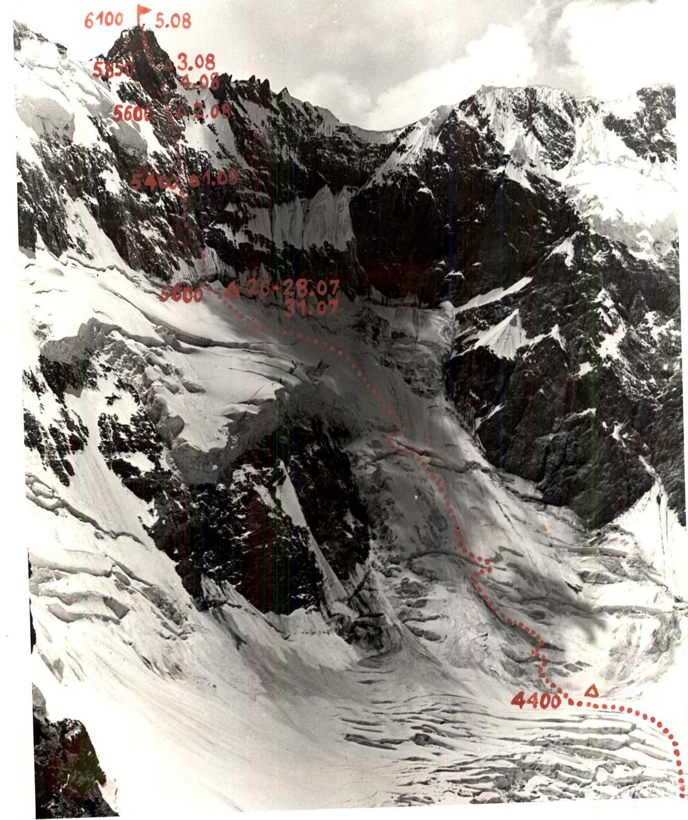
July 26
At 6:00 AM, a group of seven people left the base camp to make deliveries, process the lower part of the route, and observe the planned route from a close distance. The path we chose passed through the center of the Fortambek glacier, and where it turned towards the "Submarine", we turned left. Long observations of icefalls and rockfalls showed us that passing through the center of the branch of the glacier leading to the Borodino peak cirque is not entirely safe.
We bypassed the icefall along:
- the talus slopes of peak Moscow,
- the snow slopes of peak Moscow,
- and relatively easily reached the snow cushion at the beginning of the ice-s rock part of the route.
Here, a short rest, we put on crampons, prepare the pits — and we are at the beginning of the ice-rock part of the route.
Immediately from the snow cushion, the slope becomes quite steep (section R0–R1). The steepness is more than 40°, we avoid crevices and a large bergschrund. The slope is icy but covered with a thin layer of snow on top. We cross the first bergschrund along the ice wall.
Further, the steepness of the slope increases, and after the first bergschrund, we go along the icy slope with a steepness of about 45° for a long time (section R1–R2). We have to organize insurance. We screw in ice pits. Considering that all participants are carrying a fairly significant load of equipment and supplies, it's quite difficult to climb. We cross the slope from right to left, as according to observations, the left part has the narrowest crevices and relatively low ice walls. In short, this is the easiest and safest path here.
The entire icy slope is intersected by a wide second bergschrund (section R2–R3). We overcome it using ladders. It is quite wide, and its upper wall is 8 meters higher than the lower one. Immediately behind the bergschrund, there is a steep icy slope more than 200 m long and with a steepness of more than 50° (section R3–R4). Insurance is provided through ice pits. This icy slope is also intersected by a wide bergschrund at the top, after which we reach the snow fields. Here, the steepness drops significantly, and having passed along the snow slopes (section R4–R5), we reach a convenient place on the snow slope at the base of the rock part of the route. Here, we organize a sitting overnight stay. We prepare a place for two tents, in which we settle comfortably.
Passing the bergschrund and ice walls, we left ropes, which significantly simplified our descent:
- to the base camp,
- when exiting for the assault.
We started the ascent from the snow cushion at 9:00. We arrived under the beginning of the rock part of the route at 17:30. We prepared sites for tents, had dinner, and at 21:00, lights out. On July 27, an early departure is planned.
July 27
At 7:00, a duo of climbers was already at the bergschrund. Its upper wall rises 15 m above the lower one. We pass it on ladders (section R5–R6) in the narrowest part.
Immediately behind the bergschrund, there is a steep icy slope (section R6–R7). Its length is about two ropes. The entire slope is passed on the front teeth of the crampons. The presence of twelve-tooth crampons and an ice axe helps a lot. Insurance is provided through ice pits. The icy slope leads to steep rocks. Everywhere on the rocks, there is formed ice visible. We overcome the first section of rocks along a steep inner corner (section R7–R8). Climbing in the corner is very difficult. The presence of formed ice greatly hinders the passage. Often, it has to be hacked off, clearing the holds. Despite the good weather, it is very cold on the wall.
Further, we cross the inner corner, exit to its first part, and along a 10-meter wall (section R8–R9), we bypass the plug that ends the inner corner. Climbing on these sections is very complex. The first person works without a backpack, using the entire range of available pits. It is quite common to use ladders.
Having passed the wall, we secure the ropes and descend, as we have already spent 10 hours of hard work behind us.
Overnight stay in tents at the base of the rock part of the route.
July 28
Today, it is planned to:
- Finish processing and descend to the base camp for rest.
Therefore, the departure is early. Despite the strong cold, we leave at 6:00 AM. We pass the sections processed the day before with the help of clamps and continue further passage of the route.
The path passes along a destroyed rock wall (section R9–R10). However, the formed ice quite reliably holds the wall together, and stones do not fall. The steepness of the wall is more than 70°. For insurance, we have to drive in many pits, as the ice in the cracks where the pits are driven in causes some distrust. The rocks lead to a completely steep wall, which we begin to overcome along an inclined ledge (section R10–R11) to the left and upwards, and then along an inner corner (section R11–R12). We have to go using ladders. But this is the easiest path on this section. Along this wall, we approach an icy rock ridge (section R12–R13). We go straight up along it. Behind the ridge, there is a small ledge where we can make an overnight stay. We secure the ropes and begin our descent. We quickly gather and head to the base camp. The ropes hung during the passage of the ice walls help a lot on the descent.
July 29 and 30, the team rested in the base camp.
July 31
At 9:00, the team in full strength left the base camp and, having passed the Fortambek glacier and the ice-snow part of the route, climbed to the base of the rock part of the route.
An early departure is planned for August 1. Therefore, we go to bed very early.
August 1
We leave at 6:00 AM. It is very cold, but we need to pass the ice early in the morning. This significantly increases safety. We pass the previously processed sections of the route. The first person goes very carefully and checks:
- the integrity of the ropes,
- the quality of securing the ropes on the pits.
Further, the path passes along destroyed, frozen rocks (section R13–R14). The steepness of the rocks is more than 65°. On the section, we drive in, in addition to rock pits, two ice pits in the rocks, as rock pits, in our opinion, do not hold well on this section and are poorly driven in. Having passed the wall, we reach a steep, practically vertical edge. We pass it along an outer corner (section R14–R15). Climbing is very complex. We use ladders and use pits as artificial points of support. The outer corner leads to a protruding stone on which we organize an overnight stay. We have to work hard to get everyone seated. There is no place to set up a tent. The overnight stay is sitting. For the reliability of insurance, we drove in four bolt pits, on which we organize self-insurance.
The very complex and tense day is over. We worked for 12 working hours this day.
August 2
We leave at 9:00 AM. From the overnight stay, we go straight up along smooth slabs in the direction of a not clearly expressed counterfort (section R15–R16). The slabs are smooth and partially snow-covered and frozen. Climbing is complex. Rockfalls are possible, so we go very carefully and attentively. The wall narrows and turns into an edge (section R16–R17). The steepness of the edge is more than 75°. We drive in 14 pits on this edge. The edge leads to a narrow, steep inner corner (section R17–R18). The corner is partially filled with ice. The rocks are slippery, steep. They require high skill when overcoming. We have to hack off the ice and use ladders for passage.
The inner corner leads to a small ledge on which we organize an overnight stay. The overnight stay is sitting. Four people sit together, the rest sit in pairs. The night is cold, windy. We worked for 3 hours this day.
August 3
We leave at 7:00. From the overnight stay, we go straight up along slab-like rocks (section R18–R19), frozen with ice, and reach under the steep walls of the summit tower. The rocks of the tower are much steeper and more complex than the sections leading to them. The tower is composed of light granites and appears more solid and intact.
The height difference of the tower is about 400 m. The tower begins sharply, without smooth transitions. The steepness immediately increases strongly.
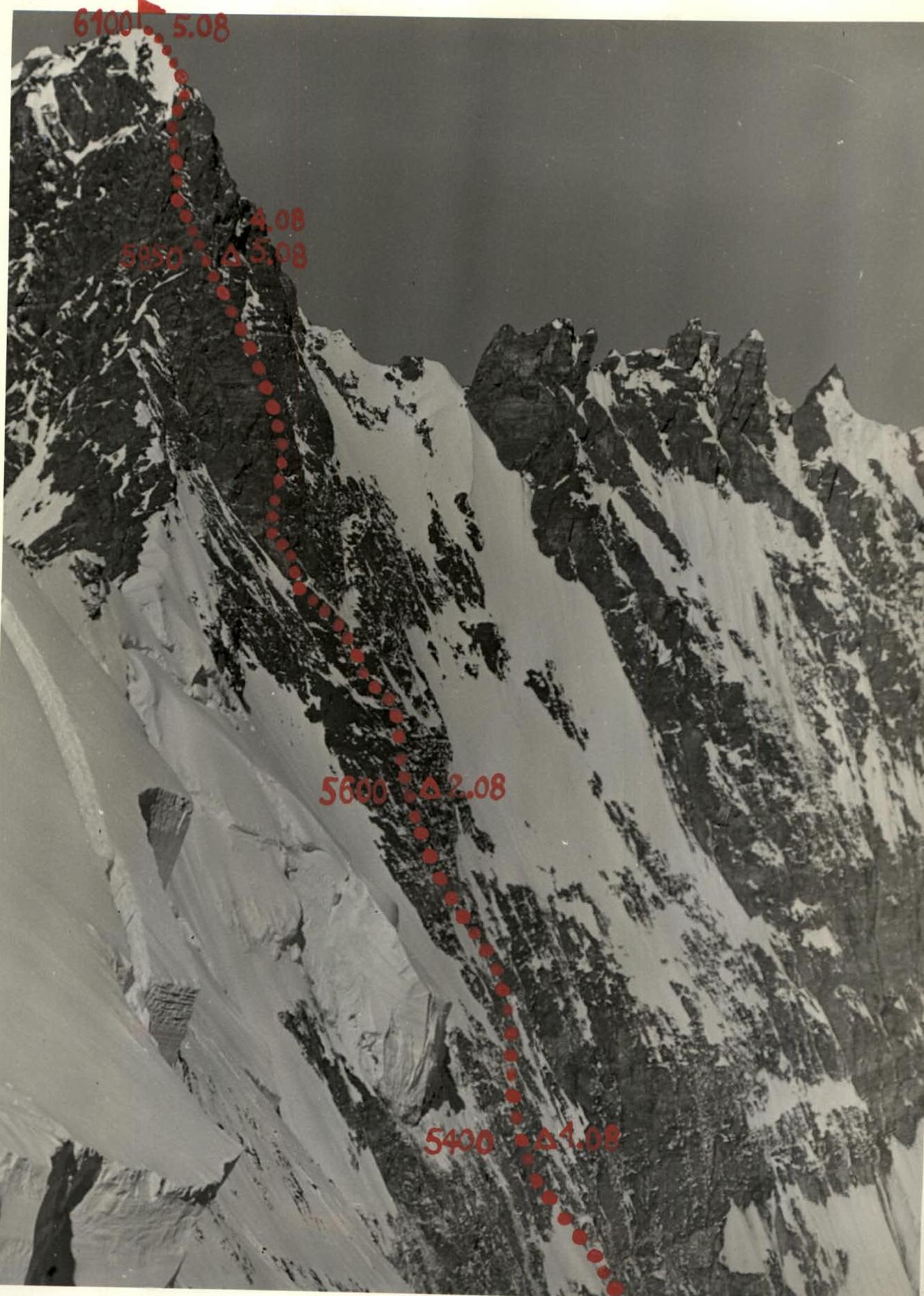
Profile of the Rock Part of the Route
The left part of the tower, along which the passage was planned, is steep rock walls. The right part is more gentle but consists of rockfall-prone, frozen slabs.
We go along the left part. The beginning is a steep inner corner (section R19–R20), leading to a protruding stone. Climbing is very complex. We use ladders. Further, we go along smooth slabs (section R20–R21). Climbing is complex. In some places, the slabs are covered with formed ice, which has to be hacked off. The wall leads to a chimney (section R21–R23). The chimney is filled with ice, and a lot of work has to be done to clear the holds and pass this section of the route with sufficient insurance. The chimney is about 50 m long. Its steepness decreases towards the top. The first 30 meters have a steepness of more than 80°, and the last twenty meters have a steepness of about 70°.
Further, we move to the right part of the chimney and approach a steep inner corner (section R23–R24). Climbing in the inner corner is extremely complex. In some places, there is ice on the rocks. We pass the inner corner using artificial points of support. The inner corner leads to a small ledge. From the ledge, along slab-like rocks in the direction to the left, we pass along slab-like rocks (section R24–R25) of a reddish color. The rocks lead to a steep ledge. Here, we organize an overnight stay. We have to work hard to create two small ledges on which we can sit:
- Four people sit on one ledge, covered with a tent;
- Three people sit on another ledge, covered with a tent;
- One person sits on a good, quite spacious ledge not far from us.
The weather is deteriorating, strong wind. It is very cold.
We worked for 11 working hours this day.
August 4
We leave at 10:00. The weather is bad. We know perfectly well that the ledge on which we spent the night is the only place on the tower where we can arrange a bivouac. Therefore, it is decided to:
- Spend another