- CLIMBING CLASS — HIGH-ALTITUDE TECHNICAL
- CLIMBING REGION — PAMIR, FORTAMBEK GLACIER
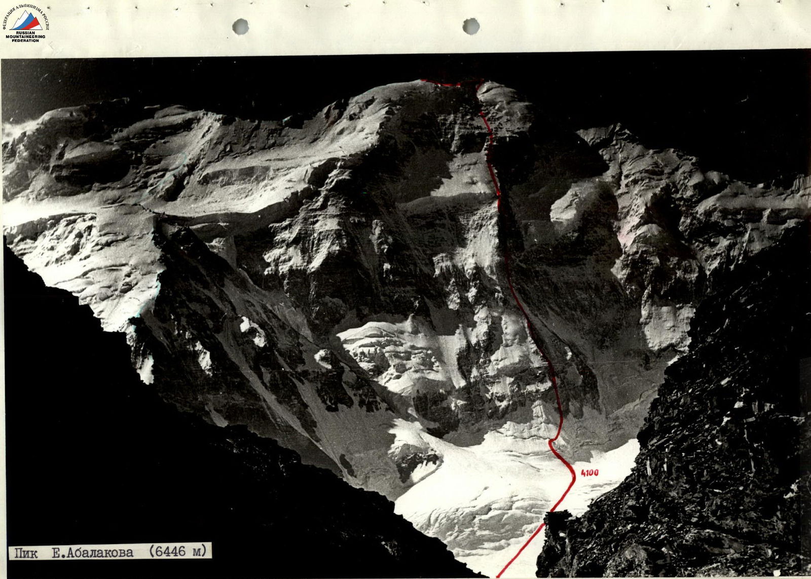
- CLIMBING ROUTE WITH SUMMIT HEIGHT — FIRST ASCENT, NORTH WALL OF PEAK E. ABALAKOV, 6446 m
- CLIMBING CHARACTERISTICS:
- HEIGHT DIFFERENCE — 2350 m
- AVERAGE STEEPNESS — 66°
- LENGTH OF DIFFICULT SECTIONS — 1250 m
- PITS SET:
- ROCK PITS — 173
- ICE PITS — 51
- TOTAL CLIMBING HOURS — 85.5 h
- NUMBER OF NIGHTS AND THEIR CHARACTERISTICS: 7, including 3 in a tent, 2 sitting together, 2 sitting apart.
- TEAM NAME: Team of Grusportkomitet
- SURNAME, NAME, AND PATRONYMIC OF THE TEAM LEADER, MEMBERS, AND THEIR QUALIFICATION:
KARTVELISHVILI Givi Irakliyevich — Master of Sports, captain SHARASHENIDZE Dmitriy Borisovich — Master of Sports, coach BAKANIDZE Tamaz Grigor'yevich — Master of Sports, team member GIUATASHVILI Roman Ivanovich — Master of Sports, team member LUKASHVILI Tariel Shalvovich — Master of Sports, team member ZUMBADZE Georgiy Shalvovich — Candidate for Master of Sports, team member KELEKHSASHVILI Dzhemal Longirozovich — 1st sports category, team member
- Dates of departure and return: August 5 — August 15, 1977
Tactical Climbing Plan
The object of the climb — Peak E. Abalakova via the north wall — was chosen by us back in 1972 as a promising target for subsequent years. Over the past period, the team has completed many well-known routes of the highest difficulty category, which naturally constituted one of the stages of preparation for this ascent.
Materials about the region were carefully studied; the responsiveness of comrades who provided us with necessary additional information helped in a thorough study of the object.
The wall's parameters dictated that the route be traversed as mobilized and powerful as possible.
To successfully solve this task, it was necessary:
- To achieve maximum sports form for each member of the assault team directly during the climb through training and active acclimatization.
- To determine the number of assault team members (7 people — dictated by reducing the specific load and self-rescue capability).
- To lighten the load through high-quality equipment and high-calorie food, allowing for minimal rope hauling.
- To maximize the use of daylight hours.
- To traverse ice sections using new techniques that ensure fast progress.
- To ensure reliable safety for people and equipment to avoid being blown off the wall by the shock wave of possible avalanches from neighboring slopes.
- To determine the best period for the ascent (through observation on site using a 6–10x spotting scope via helicopter overflight, interviewing "old-timers" at Suloyeva clearing, etc.).
The above was expected to preserve the explosive energy needed to pass the final critical section under the upper ledges.
The preliminary tactical plan for the ascent was practically executed without changes and justified itself. The only adjustment the group made was during the descent, which was carried out from the western pre-summit ridge of Peak Leningrad, due to the good condition of the icefall.
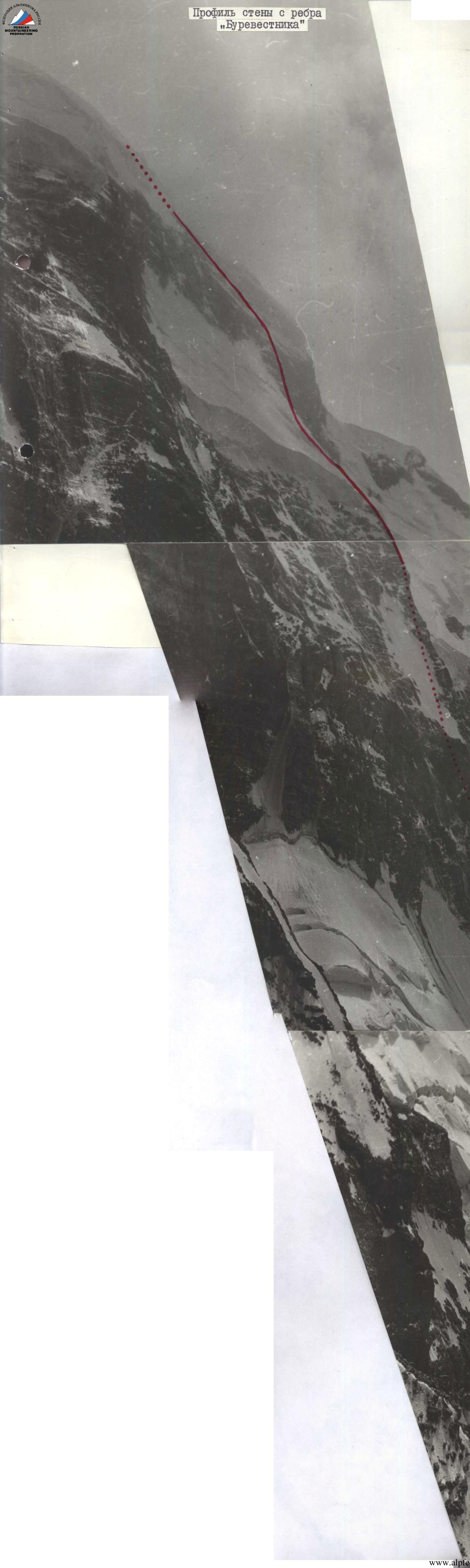
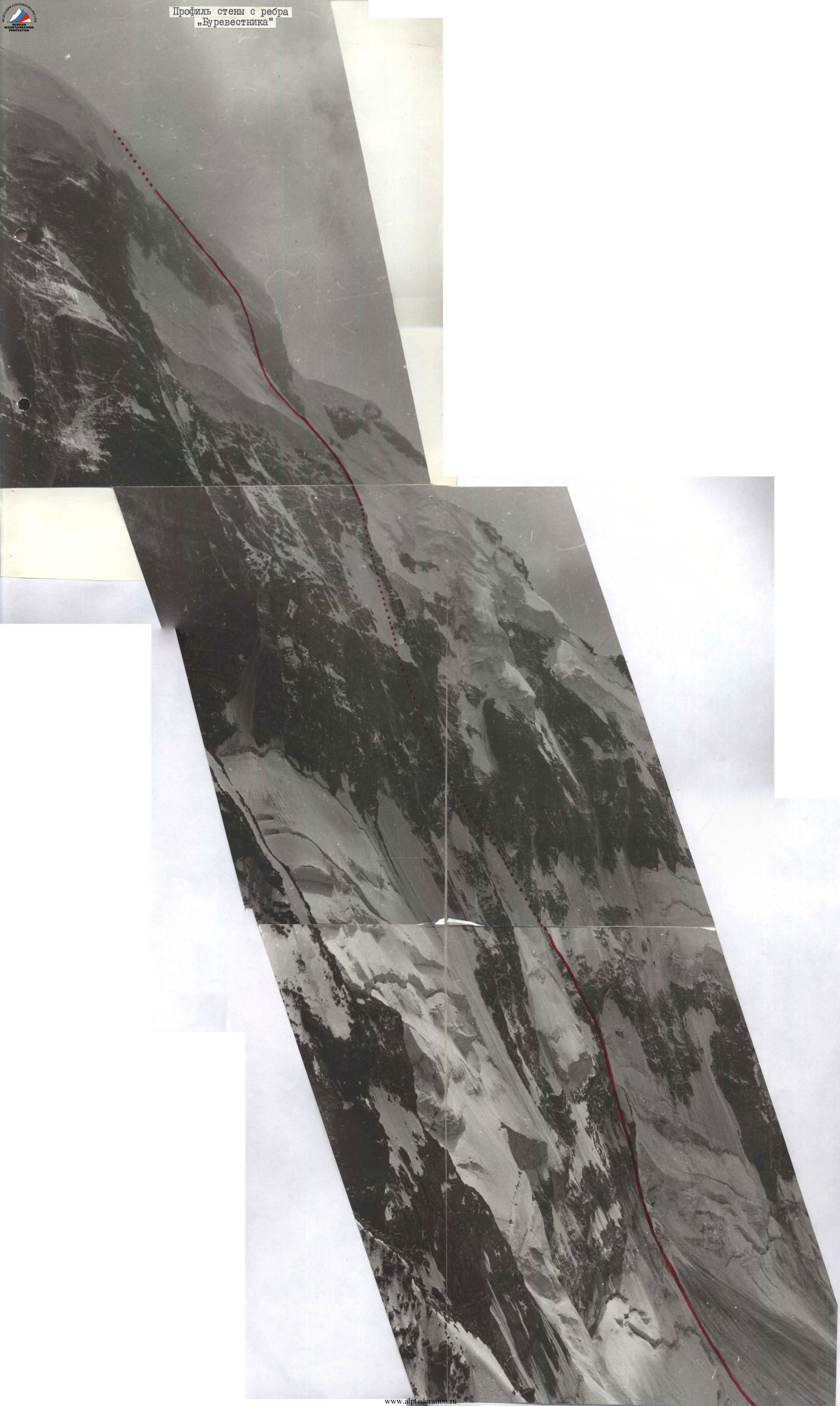
Route Description
On August 5, we depart from the base camp located at the upper end of the V. Suloeva clearing at 14:00. The trail, which crosses (orographically) the left moraine of the Fortambek glacier, leads to the glacier. We move along the trail, then along the center of the glacier upwards to the right to a large stone boulder on the median moraine of the Fortambek glacier, from where the approach to the route is planned. Organizing a bivouac above is objectively dangerous due to the possibility of powerful avalanches sweeping across the glacier.
From here, 2 teams — G. Kartvelishvili — R. Giuatashvili and D. Sharashenidze — T. Bakanidze — take the load for forwarding under the route, while the third member prepares the bivouac and observes.
The path from the boulder to the start of the route is straightforward, as it follows a gentle glacier with open crevices but with snow bridges formed by the numerous avalanches that have descended from the north wall of the cirque between the "Burevestnik" ridge and Peak "Moscow".
Forwarding and returning to the bivouac under the "Boulder" takes 4 hours. August 6. The weather is good; we depart at 6:00. We reach the load forwarding site on the glacier in 1.5 hours without our main packs. This is where the route begins. We redistribute the forwarded load among 6 backpacks.
The T. Bakanidze–Kelekhsashvili team leads the way. The firn slope with a 30° steepness leads to a "Bergschrund" with a 8-meter vertical wall (R0–R1), which is traversed using ladders.
The ice axe and crampons from "Stubai" firm, skillfully used by Bakanidze, allow for a quick passage of this wall. The others follow on the fixed ropes. Then 50 meters along an ice slope with a 45–50° steepness to R2 bergschrund, which is overcome via a 5-meter snow bridge diagonally from left to right. Safety is ensured through ice screws.
Next, we move 150–160 meters along an ice-firn 50° slope, upwards to the right (R2–R3). Movement is along fixed ropes. The ice-firn slope leads to the rocks of the left (by the route) bastion with 75–80° steepness.
We come under it. Ahead are complex rocks. The presence of wide crevices allows for reliable placement of channel and ice screws for safety. We climb 80 meters of complex rock climbing directly up the bastion to ledges above the first step of the bastion. Backpacks are hauled up. Then 45 meters along the second rock step of similar steepness, where a ledge is used to organize the reception of backpacks (R3–R4).

A control cairn is set. Then an 80–85°, 25-meter wall (R4–R5). There are few holds; climbing is complex. Above the wall is a narrow rib; a reception point for backpacks is organized (R5–R6).
Then 100 meters directly up along red, steep 70° rocks, followed by 20 meters diagonally left upwards. Climbing is complex. Movement is along fixed ropes. Despite the great steepness, four members pass this section with backpacks thanks to "Jumar" ascenders. Regrettably, the others lack such ascenders, as hauling the remaining two backpacks takes considerable time. We approach a monolithic red wall (R6–R7). Suitable bivouac sites are not visible above. A sitting bivouac is organized. 13.5 climbing hours are worked. Using daylight, Bakanidze processes 50 meters — 18–20 meters of the monolithic vertical wall with wide crevices, followed by a 50° ice slope, and then another 10-meter rock wall with 80° steepness (R7–R10). In the evening, Bakanidze returns to the bivouac site at 20:30.
August 7
On August 7, we depart at 7:30 along the fixed ropes. Lukashvili–Zumbadze lead through the wall and continue. The remaining five haul the backpacks.
Further, there are tile-like (even in color) rocks of medium difficulty, quite destroyed, 20–25 meters long. We traverse this section upwards to the right and emerge onto a sloping ledge (R10–R11).
By this time, the same team has processed 20 meters of a wall with 75° steepness, consisting of large dark-gray blocks. Climbing is complex on friction. "Vibram" soles hold well.
The wall ends on a sloping ledge. From here, steep couloirs are visible, dividing bastions to the right of our route.
Stones constantly fall into the far right couloir, likely from under the right ice ledge of the middle belt of the massif. Our reconnaissance data proved correct.
From the ledge, we climb 80 meters up 60° rocks (R11–R12). From here, the rocks become much more complex. Ahead is an 80°, 20-meter wall. Kartvelishvili–Bakanidze lead (R12–R13). The rocks are solid. Limited holds complicate climbing. After the wall, we can rest.
Before us is a rib with relatively uniform relief, above which 3–4-meter wall sections protrude in places. The total length of the section is 200–230 meters, with a steepness of 65° (R13–R14). Second control cairn. Further, the rib leads to a steep 45° ice slope with rock outcrops. The section is 75–80 meters long (R14–R15). It's difficult to climb on the front points of crampons diagonally. We stick to the pre-planned route and move under the base of the "Black Triangular Wall", which towers into the sky.
It's time to look for a bivouac. By traversing 10 meters to the right, we manage to find a ledge protected from possible ice-firn avalanches from the powerful left ledges. We construct a platform. We manage to set up a tent relatively well (R14–R15).
August 8
The whole night the wind was blowing. The weather is variable with clouds. It's cold. We delay our departure until 9:00. The rocks are of medium difficulty, with 60° steepness. Giuatashvili–Sharashenidze lead up the rocks, hanging fixed ropes (R15–R16), then pass an 80°, 18–22-meter wall on solid rocks (R16–R17), after which a 65° wide wall begins. The relief is diverse. Strongly eroded marble veins, slate slabs, and 2–3-meter steep steps in the form of isolated blocks are encountered (R17–R18). The leaders change. Kelekhsashvili–Zumbadze take the lead. The weather improves.
After passing 80 meters of steep rocks (R18–R19), we emerge onto destroyed black rocks with a smaller (50°) steepness (R19–R20). After 30 meters, we come under a steep wall. We find a suitable ledge. We start constructing a platform for the tent. By the level of Peak "Podvodnaya Lodka", we determine that we are approximately at a height of 5400 meters.
At 19:00, we contact the observers — everything is normal with them. We process 60 meters (R20–R21).
August 9, 1977
The weather is clear. There's almost no wind. Zumbadze–Bakanidze — our best rock climbers — depart at 8:30 after a snack and quickly pass the processed section. We prepare breakfast for the others, contact the observers, and dismantle the bivouac.
The first team continues along a vertical 45-meter wall (R21–R22) to a small ledge. The others, having passed the fixed ropes, haul the backpacks. Further — solid rock slabs with 65° steepness (R22–R23). At this section, we allow ourselves to rest after intense labor, as ahead of us is a black steep wall without any "hint" of ledges for a tent.
We pass 70 meters of the wall, haul the backpacks (R23–R24). At this location, we manage to set up a sitting bivouac, albeit apart. We contact the observers and request a forecast.
August 10, 1977
The weather is excellent. We wake up early and quickly gather — an advantage of a sitting bivouac. At 7:30, Kartvelishvili–Bakanidze are already working on the wall. Kartvelishvili passes 80 meters of a steep 75° wall. The others catch up and haul the backpacks onto a narrow sloping platform, where we manage to fit, hanging the backpacks (R24–R25). Above us is a wall ending in a 2–3-meter cornice, beyond which only the sky is visible. Bakanidze leads, passes 18 meters of overhanging complex climbing, and attempts to bypass the cornice on the right. However, on the visible section of the wall, there's no bypass. Bakanidze retrieves ladders.
Soon, we see the soles of his "Vibram" shoes, then he disappears over the bend (R25–R26). However, he doesn't signal readiness of the fixed ropes for a long time. We provide him with an additional 15 meters of rope. After some time, we hear a whistle — the rope is secured. We pass the cornice on ascenders and haul the backpacks. The site is inconvenient; rest is not possible. We are at the level of Peak Suloev, meaning we're somewhere near where the "Black Triangle" peak meets the ridge.
We orient ourselves on the rib visible to the left against the sky. Now, we're no longer threatened by avalanches from the left ice ledges of the middle wall belt. To the ridge, there are 80 meters of rocks, which after the cornice seem "easy", but their steepness is 70°, and climbing is complex. Kartvelishvili leads onto the rib and joyfully reports that the key site "Black Triangle" has been passed (R26–R27). Very close, 60–70 meters away, the edge of the left ice ledge of the middle wall belt is visible. This means the height is about 5800 meters. From here, the Suloev clearing and the base camp are visible. We contact the observers; they encourage us.
Kelekhsashvili–Giuatashvili, having passed 70–80 meters of rocks from black slate blocks along the rib (R27–R28), find suitable ledges for a sitting bivouac in the evening. Time is 21:30.
August 11, 1977
We didn't sleep well. It was cold and uncomfortable. The wind is blowing. We woke up early but warmed up for a long time with hot tea and cutlets. Only at 9:00 did the first team depart to hang fixed ropes. Initially along the edge of rocks and ice, then along a 45° ice slope. We pass 100–110 meters in this manner (R28–R29). The ice is uneven, with hollows and dimples — a result of the wind's work.
Ahead of us is a wide, icy rock gully, to the right of which is a steep rock wall 120 meters high. The rocks are dusted with snow (R29–R30). The rock wall rises in three large pitches.
The first rock step: 50 meters, 70°, slate slabs with a tile-like structure and few crevices filled with ice. Organizing safety takes a lot of time; climbing is complex. Above the step are inclined ledges. From here, we climb 130 meters up the second step of similar structure. Again, there are ledges. The third step is longer; the rock structure is the same, but the slabs are smaller, and there are more crevices. After 40 meters, the rocks become gentler, with a steepness of about 55° (R30–R31).
However, organizing safety becomes complicated as the rocks are covered in snow, and crevices must be found under the snow.
We move up the rocks to the right and then left towards the mouth of the ice mulde between the upper icefalls to the rock belt, after which pure ice begins. The mouth of the mulde is a corridor between the нависающими pre-summit icefalls, 130–150 meters wide. Pure ice with a steepness of 50° is visible all the way to the ridge. All snow is blown off, so there's no danger of avalanche (R31–R32). We inform the observers of this.
Under the rock step, we construct a platform and hastily set up a tent, rather than simply hanging it. We manage to fit in it, sitting. We're consoled by the warmth and the ability to communicate with each other.
August 12, 1977
The morning is clear. We wait for the first sun rays. They don't illuminate the north slopes, but seeing the surrounding mountains bathed in sunlight makes it feel warmer. Bakanidze leads, putting on crampons right in front of the tent. He passes 3 meters of rocks, then emerges above the step and begins moving left upwards towards the pre-summit ridge. The ice is hard and mirror-smooth; a web of cracks in different directions is visible. The screws are screwed in well and reliably.
Bakanidze masters the technique of passing complex ice walls using an ice axe and "Stubai" crampons. The ice axe's pick, driven into the vertical ice, holds reliably and is used as a point of support. This allows for relatively faster overcoming of ice slopes compared to usual. Therefore, all 120 meters to the ridge were passed by Bakanidze first, with the others following on the fixed ropes. It takes 3 hours for Bakanidze to reach the rocks on the ridge. Another 2.5 hours, and we gather in a large pocket between the rocks and the firn ridge leading to Peak E. Abalakova.
The wall is conquered! We feel a spiritual uplift. The main difficulties are overcome. Ahead is a relatively simple but dangerous ridge due to bilateral cornices hanging to the south and north. Attention and great caution are required when choosing the path.
A powerful front of low clouds is approaching from the southwest, hiding the panorama of distant mountains. A strong gusty wind is blowing, which sweeps away snow dust and small ice crystals, getting into goggles and down jackets. We can't continue due to limited visibility. So, at 16:00, we set up a tent in the pocket (R32–R33).
August 13, 1977
Throughout the night, the tent was battered by wind gusts, and only towards morning did it subside a bit. We depart at 10:00. Clouds are quickly moving across the sky, hiding the mountain panorama, with rare glimpses of blue-gray sky. We move along mutual fixed ropes the entire time, driving ice axes into the hard firn for safety. This slows down our movement along the ridge. The ridge has no large drops but features steep cornices hanging to the south and north, which we bypass to the left. Before the ascent to the summit, the ridge widens and becomes gentler. The height difference is small — about 30 meters. We traverse these 150 meters in independent teams. At 15:00, we remove a note from a cairn left by a team from Moscow led by V. V. Vanin on September 27, 1975. The summit is in fog. The goal is achieved! We regret only that after such efforts, we're unable to enjoy the grandeur of the surrounding panorama. Beyond the summit, the ridge widens further, and 300–350 meters can be traversed simultaneously to the bend in the ridge between Peak E. Abalakova and Peak Leningrad.
Further, the ridge narrows again, and a series of very sharp ice-firn ridges with cornices at the top is visible. Ice screws come into play. We pass a series of sharp and steep cornices in the form of "feathers". On the first expansion of the ridge to the right, we set up a tent, hoping for improved visibility.
August 14, 1977
Regrettably, visibility hasn't improved. We depart at 9:00. It's cold; snow dust is being blown off the ridge. Passing cornices and ice "feathers" requires attention and caution. We carefully ensure safety. The ridge curves to the left and then to the right in an arc and descends towards the saddle between Peak E. Abalakova and Peak Leningrad.
From several possible descent paths chosen in advance, we select a descent from the pre-summit of Peak Leningrad towards the plateau. The firn is good; ice axes hold reliably. We descend along mutual fixed ropes with upper safety immediately down 80 meters. In two places, we hang rappel. At 18:00, we're on the plateau.
We set up a tent at 19:00 near Peak "Parashyutists". We contact the observers. We attempt to "boost" our remaining food supplies. We manage to do so.
August 15, 1977
We depart at 9:00. We descend along the "Burevestnik" rib. At 18:00, we're back at the base camp in the arms of friends.
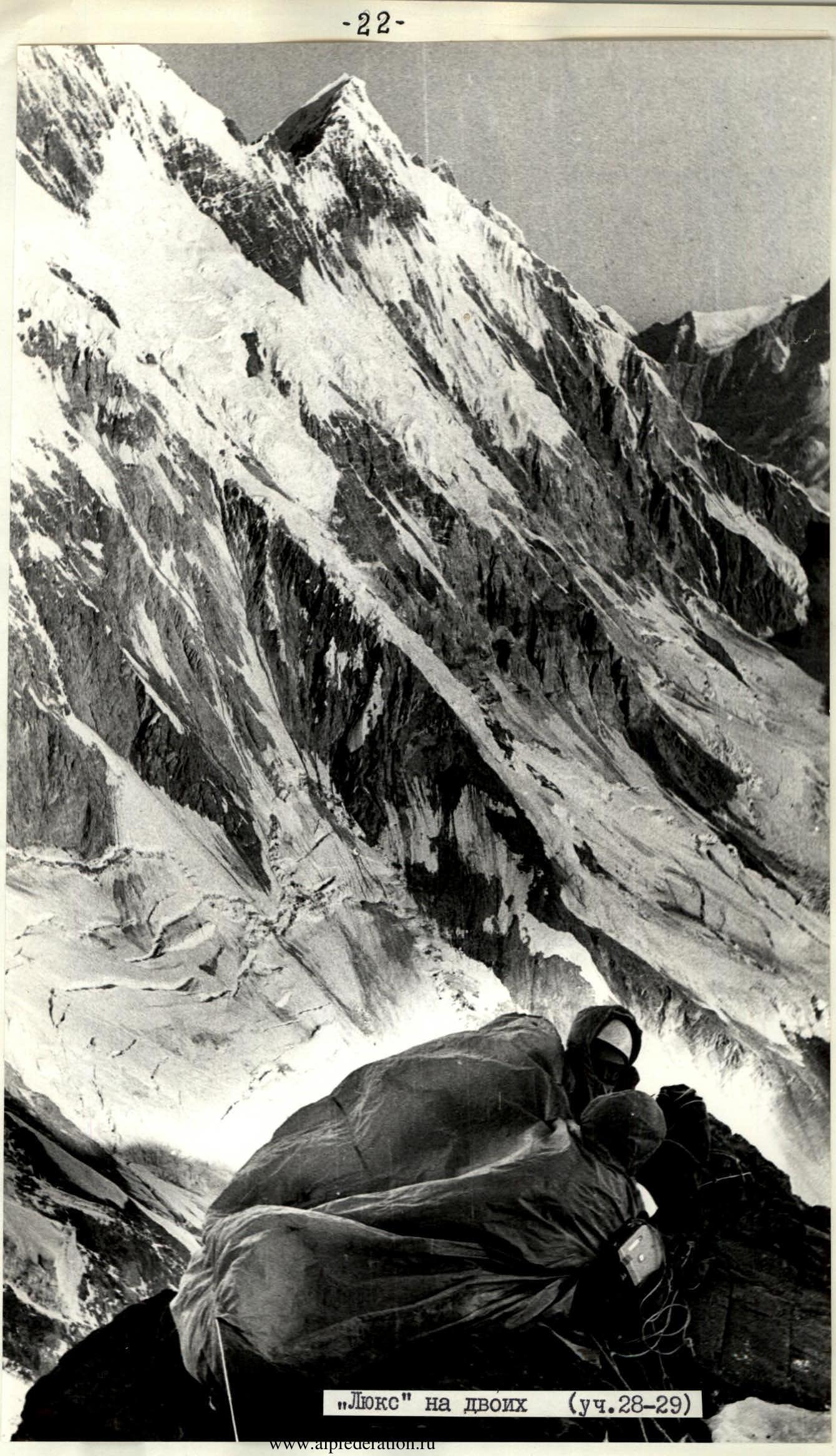

Table of Main Climbing Route Characteristics
Climbing Route: North wall of Peak E. Abalakova (Fortambek glacier)
- Height difference — 2350 m
- Length of difficult sections — 1250 m
- Average steepness — 66°

29a

29б
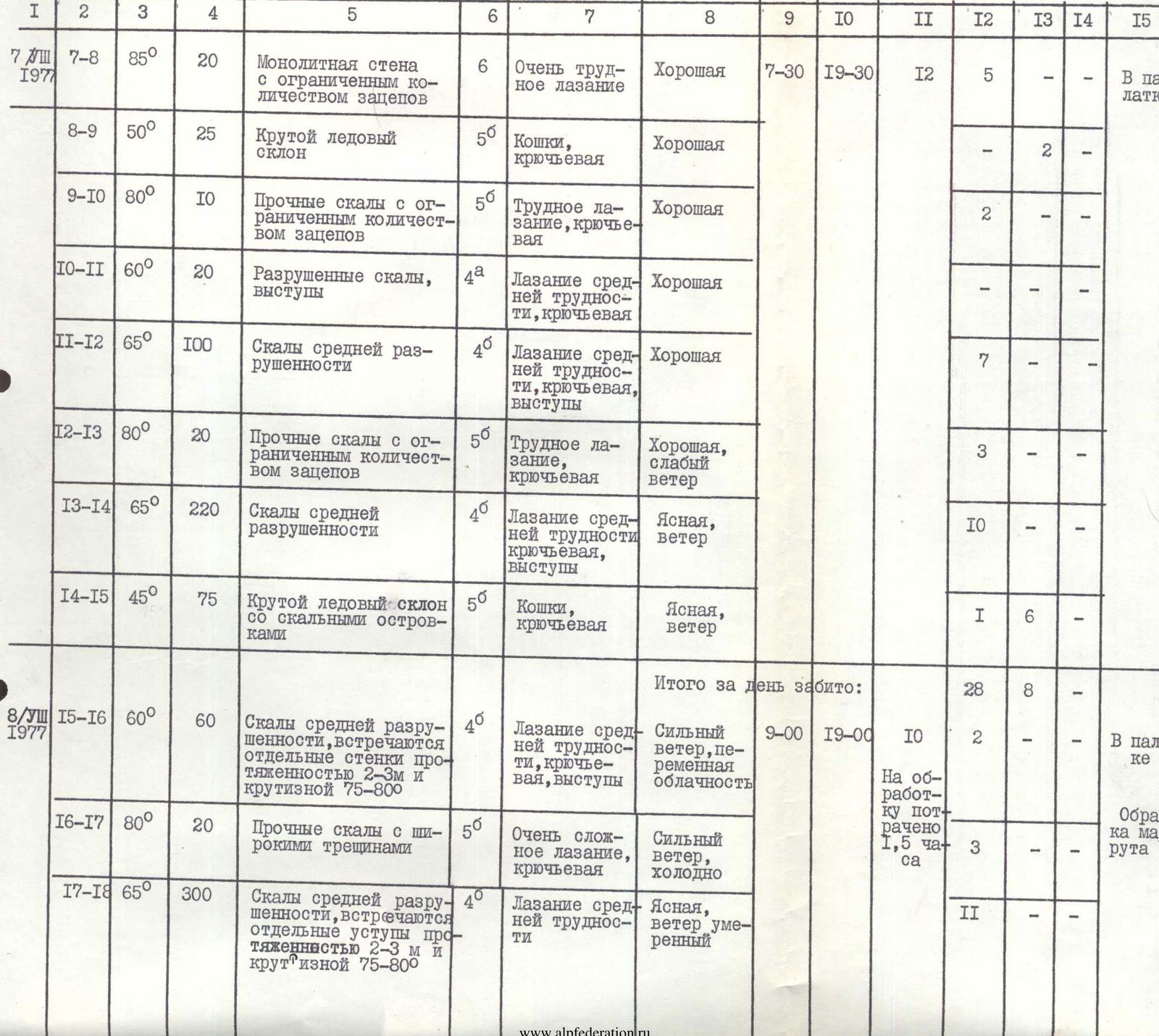
| Date | Sections Covered | Average Steepness | Section Length (in m) | Relief Character | Difficulty Category | Method of Overcoming and Safety | Weather Conditions | Departure Time | Stop Time | Climbing Hours | Rock Pits Driven | Ice Pits Driven | Shoulder Pits Driven | Bivouac Conditions |
|---|---|---|---|---|---|---|---|---|---|---|---|---|---|---|
| 6/VIII 1977 | R0–R1 | 30° | 40 | Snow-firn slope | 2 | Good | 6:00 | 19:30 | 13.5 | |||||
| R1–R2 | 80° | 8 | Ice wall | 6 | Platform, ladders, piton safety | Good | 7 | Sitting bivouac | ||||||
| R2–R3 | 50° | 200 | Steep ice-firn slope | 5 | Crampons, piton safety | Good | 14 | |||||||
| R3–R4 | 75° | 125 | Solid rocks, little destroyed | 5 | Complex climbing, piton safety | Good | 19 | |||||||
| R4–R5 | 85° | 25 | Solid rocks with limited holds | 6 | Very complex climbing, piton safety | Good, light wind | 5 | Route processing | ||||||
| R5–R6 | 45° | 15 | Destroyed rocks, easy climbing through ledges | 2 | Independent teams | Good, light wind | ||||||||
| R6–R7 | 70° | 120 | Solid, little destroyed rocks | 5 | Complex climbing, piton safety, ledges | Good, wind | 11 | |||||||
| 7/VIII 1977 | R7–R8 | 85° | 20 | Monolithic wall with limited holds | 6 | Very difficult climbing | Good | 7:30 | 19:30 | 12 | 5 | In a tent | ||
| R8–R9 | 50° | 25 | Steep ice slope | 5 | Crampons, piton safety | Good | 2 | |||||||
| R9–R10 | 80° | 10 | Solid rocks with limited holds | 5 | Difficult climbing, piton safety | Good | 2 | |||||||
| R10–R11 | 60° | 20 | Destroyed rocks, ledges | 4 | Climbing of medium difficulty, piton safety | Good | ||||||||
| R11–R12 | 65° | 100 | Rocks of medium destruction | 4 | Climbing of medium difficulty, piton safety, ledges | Good | 7 | |||||||
| R12–R13 | 80° | 20 | Solid rocks with limited holds | 5 | Difficult climbing, piton safety | Good, light wind | 3 | |||||||
| R13–R14 | 65° | 220 | Rocks of medium destruction | 4 | Climbing of medium difficulty, piton safety, ledges | Clear, wind | 10 | |||||||
| R14–R15 | 45° | 75 | Steep ice slope with rock outcrops | 5 | Crampons, piton safety | Clear, wind | 1 | 6 | ||||||
| 8/VIII 1977 | R15–R16 | 60° | 60 | Rocks of medium destruction, with individual wall sections | 4 | Climbing of medium difficulty, piton safety, ledges | Strong wind, variable cloudiness | 9:00 | 19:00 | 10 | 2 | In a tent | ||
| R16–R17 | 80° | 20 | Solid rocks with wide crevices | 5 | Very complex climbing, piton safety | Strong wind, cold | 3 | Route processing | ||||||
| R17–R18 | 65° | 300 | Rocks of medium destruction, with individual steep sections | 4 | Climbing of medium difficulty | Clear, moderate wind | 11 | |||||||
| 9/VIII 1977 | R18–R19 | 70° | 80 | Solid rocks with limited holds and wide crevices | 5 | Very difficult climbing, piton safety | Clear, moderate wind, cold | 15 | Sitting bivouac in different places | |||||
| R19–R20 | 50° | 30 | Destroyed rocks, through ledges | 3 | Easy climbing | Clear, moderate wind | ||||||||
| R20–R21 | 75° | 60 | Solid rocks with limited holds and crevices | 5 | Very difficult climbing, piton safety | Good, light wind | 8:00 | 21:30 | 13.5 | 9 | ||||
| R21–R22 | 85° | 45 | Solid, large-block rocks. Crevices predominantly vertical, wide | 6 | Very difficult climbing | Good, light wind | 10 | |||||||
| R22–R23 | 65° | 30 | Solid, slab-like rocks. Crevices wide, limited holds | 5 | Difficult climbing, piton safety | Good | 3 | |||||||
| R23–R24 | 75° | 70 | Solid, slab-like rocks. Limited holds. Individual ledges encountered | 5 | Difficult climbing, piton safety | Good | 8 | |||||||
| 10/VIII 1977 | R24–R25 | 75° | 80 | Solid rocks with limited holds | 5 | Difficult climbing | Good | 8:00 | 21:30 | 13.5 | 30 | Sitting bivouac in different places | ||
| R25–R26 | 85° | 20 | Solid rocks with limited holds and crevices. Wall ends in a cornice | 6 | Very complex climbing, platform, ladders | Good | 10 | |||||||
| R26–R27 | 70° | 80 | Solid rocks. Convenient holds | 5 | Complex climbing, piton safety | Good | 11 | |||||||
| R27–R28 | 60° | 70 | Rock rib | 4 | Climbing of medium difficulty, piton safety, ledges | Good | 2 | |||||||
| 11/VIII 1977 | R28–R29 | 45° | 110 | Steep ice slope | 5 | Crampons on front points, ice axe for additional support | Strong wind, clear | 8:30 | 19:30 | 11 | 8 | In a tent | ||
| R29–R30 | 70° | 120 | Tile-like solid rocks with limited holds | 5 | Complex climbing | Strong wind | 13 | |||||||
| R30–R31 | 55° | 220 | Tile-like rocks. Many holds. Individual ice sections encountered | 4 | Climbing of medium difficulty, piton safety, through ledges | Strong wind | 5 | 1 | ||||||
| 12/VIII 1977 | R31–R32 | 50° | 120 | Steep ice slope of the mulde, mirror-smooth ice | 5 | Crampons for additional support, "Stubai" ice axe, piton safety | Hurricane-force wind, cold. Clear. | 10:00 | 16:00 | 6 | 13 | In a tent | ||
| 13/VIII 1977 | R32–R33 | 10–150 | 600 m | Sharp snow-firn ridge with large cornices on both sides | 5 | Crampons, safety through ice axe | Fog, moderate wind | 10:00 | 14:30 | 4.5 |
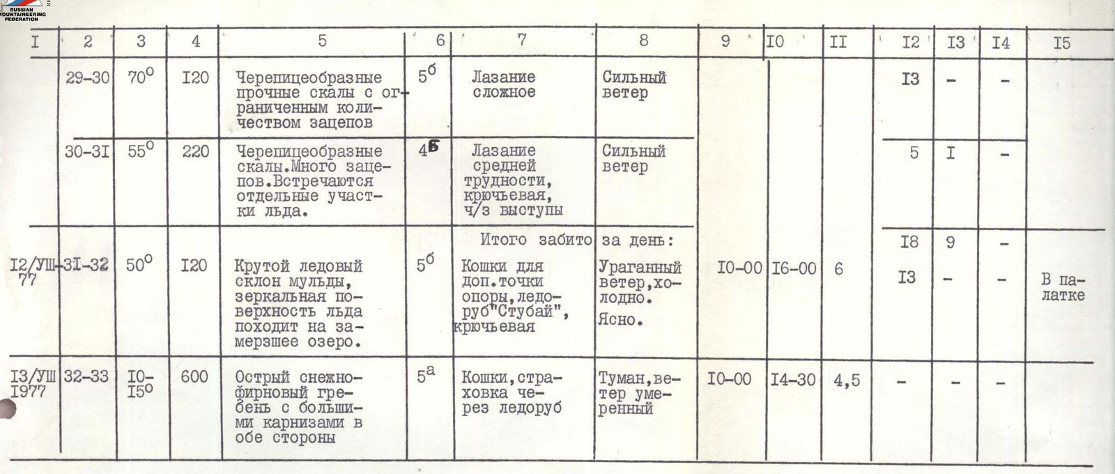
Total pits driven: 224, including rock — 173, ice — 51.
Climbing hours (including processing time) — 85.5 h. Additionally, for organizing bivouacs, the following pits were driven: rock — 41, ice — 17.
Team Captain, Master of Sports of the USSR T.I. KARTVELISHVILI
Team Coach, Master of Sports of the USSR D.B. SHARASHENIDZE