- Climbing category – high-altitude and technical
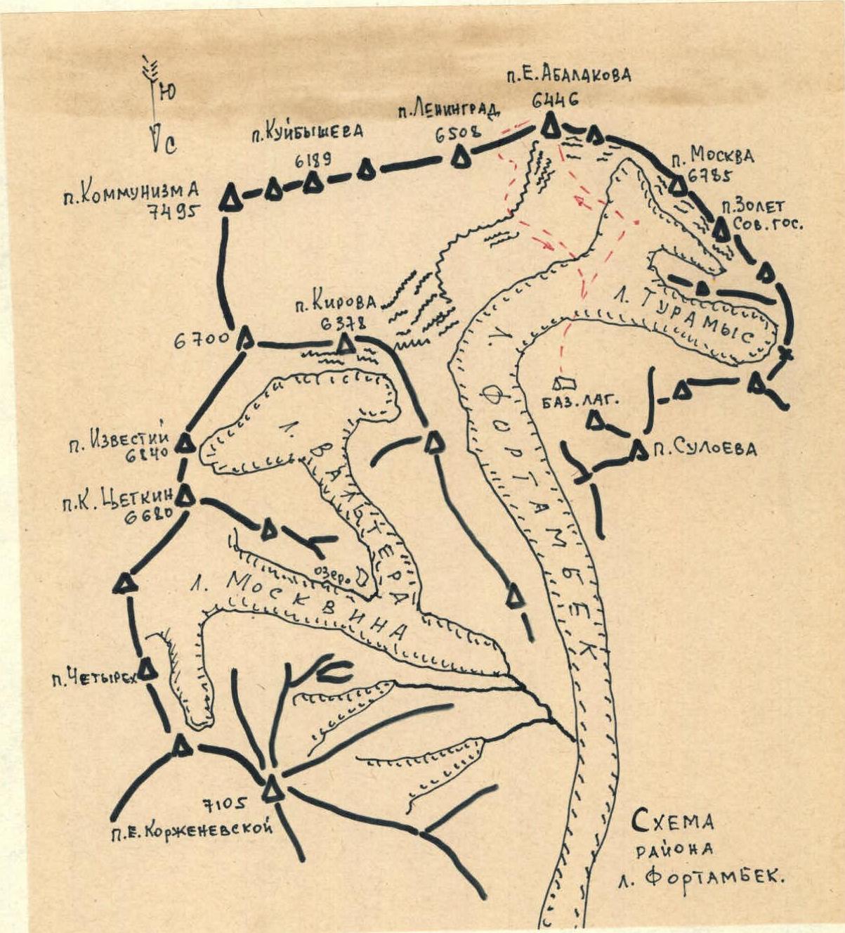
- Climbing region, ridge – Pamir, Fortambek glacier, Peter I Ridge.
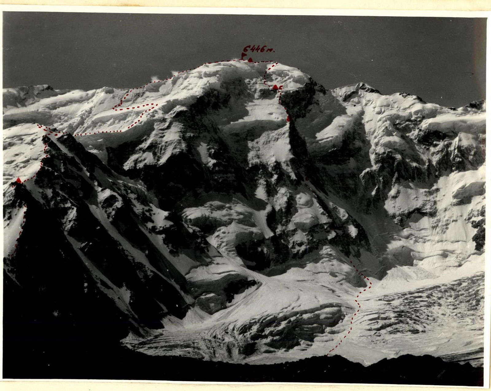
- Peak, its height, route – Peak E. Abalakova, 6446 m, via the N wall.
- Proposed difficulty category – 5B (second ascent)
- Route characteristics: height difference 2350 m length of difficult sections 5–6 cat. of difficulty 1410 m average steepness 66°
- Pitons hammered: for belaying – 163, for creating artificial anchors – 0 steel – 148 (15 of them at bivouacs), ice – 15, bolt – 0
- Number of climbing hours – 62.5 (including 12 hours descent)
- Number of bivouacs: 5 on ascent, 3 of them sitting, 1 on descent, total 6 bivouacs.
- Surname, name, patronymic of the team leader, participants and their qualification Bobrov Vladimir Ivanovich – Candidate Master of Sports, team leader Kurochkin Gennadiy Aleksandrovich – Candidate Master of Sports, participant Khomutov Valeriy Vasil'evich – Candidate Master of Sports, participant Chyornyy Nikolay Dmitrievich – Candidate Master of Sports, participant Team of MAL "Pamir-78"
- Team coach: Honored Master of Sports of the USSR, Honored Coach of the RSFSR A. G. Ovchinnikov.
- Date of departure and return July 15 – July 21, 1978
Brief geographical overview of the climbing region
The object of the ascent – Peak E. Abalakova (6446 m) is located in the Pamir in the upper reaches of the Fortambek glacier in the Peter I Ridge. The Fortambek glacier is bordered on the right orographic side by powerful ridges. On the northern slopes of Peak Kommunizma – Leningrad at an altitude of about 6000 m is the Big Pamir firn plateau, which is one of the most interesting places in the Pamir.
Peak E. Abalakova is located at the western edge of the firn plateau between Peaks Leningrad and Borodino and drops down to the Fortambek glacier with a steep northern wall 2.5 km high.
The northern exposure, powerful glaciation make the entire northern facade of the Peter I Ridge from Shinn-Bini pass to Peak Leningrad very difficult to access and complex. The development of the northern slopes of the Peter I Ridge by climbers has taken place over the last 10 years. The use of helicopters has opened up very wide possibilities, and the Suloeva clearing on Fortambek has become very popular.
In 1968, the first route to Peak Kommunizma was made through the Pamir firn plateau along the "Burevestnik" ridge by a group led by V. Maksimov, and in 1971 a group led by I. Getman made an ascent on the eastern part of the North wall of the plateau to the right of the Trampolinny glacier.
For the first time, Peak E. Abalakova was climbed in 1959 by a group led by K. Kuzmin during a traverse of Peaks Leningrad – Borodino. The ascent to the ridge was made from the south from the Lipskiy glacier. In 1975, Peak E. Abalakova was visited by a group led by V. Vanin, who made a traverse of Peaks Moskva – Kommunizma. The conquest of the northern slopes of the Peter I Ridge was on the agenda. In 1977, three new complex routes were made on these slopes:
- the North wall of Peak E. Abalakova was conquered by a team of Georgian climbers led by Kartvelishvili;
- Peak Moskva was conquered by a team of Ukrainian climbers led by Cherevko;
- Peak 30 Years of the Soviet State was conquered by a team of Polish climbers from the MAL "Pamir-77" camp.
The ascent of the MAL "Pamir-77" team, composed of climbers from the "Burevestnik" society, to Peak E. Abalakova via the North wall was the second ascent of this complex and beautiful route, which was awarded a silver medal in the 1977 USSR Climbing Championship in the high-altitude and technical climbing category.
Route description
July 13, 1978. Everything is ready for departure. The team of Khomutov – Chyornyy departed at 6:00 to process the route, to take a closer look. From 9:00, the team of Bobrov – Kurochkin observed the work of the first team through binoculars from the moraine of the Fortambek glacier. By 14:00, the team of Khomutov – Chyornyy had passed the bergschrund and another two ropes on the rocks, everything is going well. This year there is very little snow, it is necessary to take into account the possible increase in rockfall danger. By 17:00, the team returned to the camp from the route.
July 15, 1978. At 5:00, the group departed from the camp on the Suloeva clearing in full strength. The bergschrund was very simple this year and did not cause much trouble, and a rope was left there by the descending team. By 9:00, they reached the rocks.
At first, 80 m (two fixed ropes) straight up the complex rocks (75–80°) of the bastion were passed quite quickly and easily with the help of "Jumar" ascenders, which each participant had (taking into account the recommendations of the first ascenders). Khomutov went first with a lightened backpack.
Further:
- up – to the right along the second rock ledge of approximately the same steepness under a steep rise;
- a note from the Georgian team was found from the control tour;
- ahead was a wall 80–85°, approximately 25–30 m.
It went quite smoothly; the first climber removed his backpack and passed the wall. The others went using "Jumars" – it was a bit heavy, but they managed. The last one passed with "Jumars", controlling the backpack, which was pulled up by the trio above.
Further, the path went along rusty rocks 70°:
- first 100 m up, rocks destroyed;
- then 20 m to the left – up.
The rocks were complex, but passable with backpacks – they were light enough, and "Jumars" helped, holding reliably.
They approached a monolithic rusty wall and to the right of it, under a small overhang, found a small ledge for a sitting bivouac. From 18:00 to 20:00, the team prepared the site, so they hung a tent, and could almost lie down. During this time, Khomutov and Chyornyy processed one rope:
- first 20 m to the right traverse;
- then 20 m straight up.
The rocks were strong enough, but steep 85°. They followed the description of the Georgian group.
July 16, 1978. The ascent was at 6:00, but preparations were long, as the site was small and inconvenient, so they departed around 9:00. They continued along the rope fixed the day before, then rocks of medium difficulty, destroyed – 20–25 m under a wall 75° of dark-gray blocks.
On the wall, climbing was complex, but friction was good, and crampons held very well on such rocks.
Further:
- rocks were gentler – about 60°, approximately 80 m;
- again a wall 20 m steepness 80°, which led to a ridge 200 m long with a steepness of 65°.
There were separate small walls 2–4 m. They found a note in the second control tour.
Further, another 80 m along the ridge to a snow slope with a steepness of 45–50°, about 20 m. Compared to the Georgian team's description – there was much less snow and ice.
After the snow slope – along strongly destroyed rocks 240 m to the center of the yellow wall.
The last rope on that day was passed by Khomutov first without a backpack, and he reached a ledge under an overhanging light-rusty rock at 17:00, where they set up a sitting bivouac. Then the first climber returned for his backpack and passed along the rope with a "Jumar".
While Bobrov – Kurochkin set up a bivouac, the team of Khomutov – Chyornyy fixed two ropes and returned to the bivouac by 19:00.
They were lucky with the weather – calm and warm. The route was logical, and it was hard to get lost, as rocks fell constantly along the couloirs on both sides. This forced them to look for a bivouac under cover – it was inconvenient, but safe, and random rocks did not fall. Radio communication with the camp was excellent.
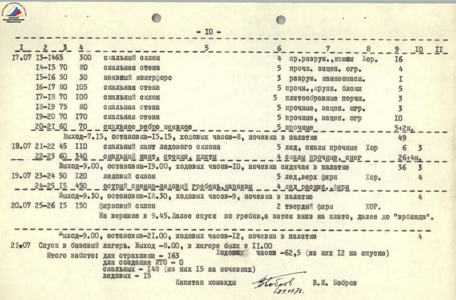
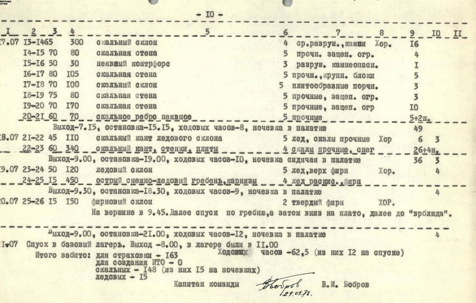
July 17, 1978. They slept poorly, the ledge was too narrow. They departed at 7:15 and by 9:00 had passed the fixed ropes, then another 3 ropes (120 m) along steep rocks to a ledge, where they found traces of the Georgian team. Further:
- 840 m up along strongly destroyed rocks 60°.
- At 12:00, they stopped for a snack. The weather was getting worse.
- Further – again along a barely visible ridge for another 300 m or so.
- At 15:30, they reached the bivouac site of the first ascenders.
Two hours of work, and they managed to set up a tent, although not very level.
July 18, 1978. The night was bad, the site was uneven, and there was a strong wind. They departed after communication with the camp at 9:15. First, along the edge of snow and rocks, about 320 m to a rock barrier, which they reached at 13:45. Further, the path went along rocks towards an ice couloir (up – to the left). The rocks were steep 65–75°, with separate walls 5–8 m. The rocks were snow-covered, requiring careful belaying and cautious movement. Having passed about 600 m by 19:30, they passed the "neck" of the couloir and reached more gentle snow-covered rocks. On a narrow but long ledge, they set up a sitting bivouac in a suspended tent. But from here, they could already see the ridge and the ice slope leading to it.
July 19, 1978. The night was not good. They departed late at 9:30 after communication. The path went straight up along snow-covered rocks with a steepness of 50–55° for about 300 m, which led to an ice slope with a steepness of about 50°. Along this slope, about 160 m, at first steep, then 100 m more gentle 40°, they reached the outcropping rocks on the ridge around 15:00. A short rest, and then to the left along the ridge 160 m. The ridge was sharp with delicate cornices to the south, requiring alternating movement. At 18:30, on a wide pre-summit ridge, they finally set up a tent on snow.
July 20, 1978. They got up at 7:00. It was cold at night. They departed at 9:00. In 30 minutes, they were on the summit. The weather was good. They found a note from the Georgian team. From the summit to Peak Leningrad, the ridge was initially narrow and corniced. They moved alternately from the southern side. They passed 100 m to a drop in the ridge. Here, there was no cornice. And then they began to descend via sport route downwards to the plateau between two rock "islands", 40 m to the rocks, and further 40 m from the rocks. Further, another 80 m with belaying through an ice axe. Further, along a gentle slope above the drops, descending to the plateau, they turned left towards the slopes of Peak Abalakova, and there down to the plateau – 80 m via sport route with rope retrieval (left the tent poles) – descended to the plateau. By 21:00, they were on the "camel".
July 21, 1978. They departed at 8:00 and by 11:00 were at the base camp on the Suloeva clearing.
TABLE OF MAIN CHARACTERISTICS OF THE ASCENT ROUTE Ascent route: North wall of Peak E. Abalakova (Fortambek glacier) 5B, second ascent Height difference – 2350 m. Length of difficult sections – 1410 m. Average steepness – 66°.
| Date | Section | Average steepness in degrees | Length in meters | Relief character | Difficulty | Condition Weather conditions | Pitons | Ice pitons | Bolt pitons |
|---|---|---|---|---|---|---|---|---|---|
| 15.07 | 0–1 | 30 | 40 | Firn slope | 2 | Hard firn Good | |||
| 1–2 | 50 | 200 | Ice slope, ledges, small walls | 5 | Firn, ice | 4 | |||
| 2–3 | 75 | 125 | Rock wall | 5 | Strong rock | 9 | |||
| 3–4 | 85 | 25 | Wall, initially inner corner | 6 | Strong, smooth | 3 | |||
| 4–5 | 45 | 15 | Rock slope | 2 | Destroyed, rockfall | 1 | |||
| 5–6 | 70 | 120 | Rock wall | 5 | Medium strength | 10 | 5 reg. | ||
| Departure – 5:00, stop – 18:30, climbing hours – 13.5, bivouac sitting with a tent | 28 | 4 | |||||||
| 16.07 | 6–7 | 75 | 45 | Rock wall | 6 | Medium destroyed Good | 2 | ||
| 7–8 | 80 | 10 | Rock wall | 5 | Strong, few holds | 1 | |||
| 8–9 | 60 | 120 | Rock counterfort, vague | 4 | Destroyed, rockfall danger | 6 | |||
| 9–10 | 80 | 20 | Rock wall | 5 | Strong rock | 2 | |||
| 10–11 | 65 | 220 | Vague counterfort | 4 | Medium destroyed | 12 | |||
| 11–12 | 45 | 75 | Vague ridge, rock walls | 4 | Medium destroyed | 4 | |||
| 12–13 | 70 | 80 | Vague wide counterfort | 5 | Medium destroyed | 4 | 4 reg. | ||
| Departure – 9:00, stop – 18:00, climbing hours – 9, bivouac in a tent sitting | 35 | ||||||||
| 17.07 | 13–14 | 65 | 300 | Rock slope | 4 | Medium destroyed, rocks Good | 16 | ||
| 14–15 | 70 | 80 | Rock wall | 5 | Strong, limited holds | 4 | |||
| 15–16 | 50 | 30 | Vague counterfort | 3 | Destroyed, rockfall danger | 1 | |||
| 16–17 | 80 | 105 | Rock wall | 5 | Strong, large blocks | 5 | |||
| 17–18 | 70 | 100 | Rock slope | 5 | Plate-like rocks | 3 | |||
| 18–19 | 75 | 80 | Rock wall | 5 | Strong, limited holds | 3 | |||
| 19–20 | 70 | 170 | Rock wall | 5 | Strong, limited holds | 10 | |||
| 20–21 | 60 | 70 | Rock ridge vague | 5 | Strong | 5 | 2 reg. | ||
| Departure – 7:15, stop – 15:15, climbing hours – 8, bivouac in a tent | 49 | ||||||||
| 18.07 | 21–22 | 45 | 110 | Rock edge of ice slope | 5 | Ice, strong rocks Good | 6 | 3 | |
| 22–23 | 60 | 340 | Rock edge, walls, slabs | 4 | Strong rocks, snow | 26 | 4 reg. | ||
| Departure – 9:00, stop – 19:00, climbing hours – 10, bivouac sitting in a tent | 36 | 3 | |||||||
| 19.07 | 23–24 | 50 | 120 | Ice slope | 5 | Ice, upper firn Good | 4 | ||
| 24–25 | 15 | 450 | Sharp snow-ice ridge, cornices | 4 | Ice softened, firn | ||||
| Departure – 9:30, stop – 18:30, climbing hours – 9, bivouac in a tent | 4 | ||||||||
| 20.07 | 25–26 | 15 | 150 | Firn slope | 2 | Hard firn Good | |||
| At the summit at 9:45. Further descent along the ridge, and then down to the plateau, and then to the "camel". | |||||||||
| Departure – 9:00, stop – 21:00, climbing hours – 12, bivouac in a tent | 4 | ||||||||
| 21.07 | Descent to the base camp. Departure – 8:00, arrived at the camp at 11:00 |
Total pitons hammered: for belaying – 163 for creating artificial anchors – 0 rock – 148 (15 of them at bivouacs) ice – 15 Climbing hours – 62.5 (12 of them on descent)
Team captain V. I. Bobrov
- 10 -
Protocol of the review of the ascent to Peak E. Abalakova via the North wall 5B category of difficulty, second ascent (Georgian route) of the group led by Bobrov V. I.
Bobrov. The team consisting of Bobrov, Kurochkin, Khomutov, Chyornyy departed from the camp at 5:05 on July 15, 1978. Since on July 13, the team of Khomutov – Chyornyy processed the beginning of the route (3 ropes), the group started the ascent quickly. On the first day, they passed about 100 m higher than the first ascenders. In general, they moved faster because there were 4 people, they knew the route, had "Jumars", and lighter equipment. On the third day, having passed the most difficult sections, they reached a vague ridge. Here, the route is combined, rocks with snow and ice. Further, they reached the ridge of Peak E. Abalakova and on the beginning of the 6th day, they were on the summit. On the 7th day, by 11:00, they were back in the camp. Everything went according to plan. It should be noted that this year there was less snow and, apparently, that's why more rocks were falling. But the route is logical, it goes along vague counterforts and is relatively safe from rockfall, but you need to be attentive. This route can be recommended for our groups as well as for foreign climbers. There are no remarks about the participants.
Galkin O. How many products did you take?
Bobrov. At the rate of 400 g per person per day for 9 days, that's about 14.5 kg.
Khomutov. The group passed the route in good style, very evenly loaded, about 20 ropes per day.
Galkin O. I consider it possible and necessary to certify the group's ascent and Bobrov's leadership.
Chairman Head of the sports department MAL "Pamir-78" A. Ovchinnikov
d. Fortambek July 24, 1978