
PASSPORT
of the ascent made in the USSR Championship in mountaineering 1975
- Ascent class — traverse.
- Ascent area — South-West Pamir.
- Ascent route — peak 5243 via the western wall, peaks 5085–4927–4670–4700–5158–5150, 4980, 4495–4960–5214 Akmu–5558 Shpil–5527 Tri Bashni.
- Ascent characteristics height difference of peak 5243 m — 1100 m, average steepness 80°, length of complex wall sections 770 m, length of complex sections of the entire traverse 1490 m.
- Number of pitons used: rock — 892, ice — 108, bolt — 2.
- Number of climbing hours — 173.
- Number of bivouacs and their characteristics: reclining bivouacs in a tent — 16 sitting in a tent — 1 sitting separately — 1 hanging in a hammock — 1
- Team name Sports Committee of Ukraine
- Full name of the captain, coach, and participants: Krasnoshchyokov Nikolai Alekseyevich — CMS, team captain; Polevoy Igor Vladimirovich — MS, senior instructor, team coach; Paliy Ivan Nikolayevich — CMS, participant; Kruglikov Leonid Grigoryevich — CMS, participant; Ponomaryov Eduard Vasilyevich — CMS, participant.
- Date of first ascent July 31, 1975 — September 17, 1975.
- Place taken by the team
1. Brief geographical description and sports characteristics of the ascent area
Peaks of the traverse:
- 5243 m
- 5085 m
- 4927 m
- 4670 m
- 4700 m
- 5158 m
- AKMU
- 5150 m
- 4980 m
- 4495 m
- 4960 m
- 5214 m (AKMU)
- 4900 m
Garm-Chashma 5558 m Shpil, 5527 m Tri Bashni are located in the South-West Pamir region, which stretches from the Bartang River in the north to the Panj River in the south and from Panj in the west to the line crossing Lake Sarez and Yashinkul in the east.
The southern part of the western boundary of the region is formed by the Ishkashim Range, which stretches for more than 300 km from northwest to southeast. The highest point of the Ishkashim Range is peak Mayakovsky — 6096 m.
The peaks of the traverse are located in the spurs of the Ishkashim Range. At the same time, two peaks of the traverse: peak 5558 m Shpil and peak 5527 m Tri Bashni — are located in the Ishkashim Range northwest of peak Mayakovsky, the remaining peaks of the traverse formed a spur of the Ishkashim Range, running from south to north. From the northwest, the spur of the traverse is bounded by the Vez-Dara and Garm-Chashma valleys, from the southeast — by the Badom-Dara valley.
2. Relief features
The western wall of peak 5243 m drops down to the Vez-Dara valley by 1100 m. The rock part of the wall, more than 700 m long, consists of sedimentary rocks: shales, granites, quartz. The western wall is snowless, monolithic. In some areas, there are overhangs.
The exit to the wall is safe but very difficult due to the great steepness of the route.
Some sections of the western wall are loose rock.
The northeastern and northern slopes of the peaks, along which the ascent was made, are ice-snow or ice-rock; the southwestern and southern slopes, along which the descent was made, are rocky ridges of varying steepness made of destroyed and semi-destroyed rocks with some sheer walls.
3. Weather conditions
The South-West Pamir is characterized by very stable good weather. This was confirmed during our stay in the Vez-Dara valley. During the expedition's work, from July 5 to August 18, there were only three cloudy days at the base camp — slight cloudiness without precipitation.
When traversing the route for 20 days, there were two days of bad weather — snowfall, fog. But in general, the weather conditions were very satisfactory, and almost all ascents were made in clear weather.
4. Remoteness from settlements
The South-West Pamir is located on the border with Afghanistan down to the village of Vez-Dara. There is a good road:
- 800 km from the city of Osh;
- 608 km from Dushanbe through Khorog, Roshtkala.
We reached the village of Vez by car in 2 days. The expedition moved to the upper reaches of the Vez-Dara valley with a pack train along the trail for 5–6 hours. The base camp was located at an altitude of 3600 m.
5. Exploration of the area
For a long time, the South-West Pamir was considered outside the activities of mountaineers. In 1987, geologist S. I. Klunnikov discovered two peaks above 6000 m in the Shakhdara Range and named them peak Marx and peak Engels.
In 1946, a group led by E. Abalakov ascended peak Marx 6726 m.
In 1947, a group led by V. Budanov ascended peak Mayakovsky 6097 m, located in the Ishkashim Range.
In 1954, the South-West Pamir region was visited by an expedition of the Georgian Mountaineering Club. In 1958 — an expedition of the MGS DSO "Trud", in 1961 and 1962 — expeditions of LOS DSO "Burevestnik" led by Savvon.
Several routes of the highest category of difficulty have been completed on:
- peak Karl Marx;
- peak Engels;
- peak Tajikistan.
However, the area of the Ishkashim Range northwest of peak Mayakovsky was rarely visited by mountaineers. In 1973, a group of mountaineers from the Kharkov "AvanGuard" led by Grigorenko–Prigoda made an ascent to peak Shpil 5558 m via the northwestern wall.
In 1974, ascents were made to peak 5527 m Tri Bashni by mountaineers from the Sverdlovsk Sports Committee via the southeastern wall, and to peak AKMU 5214 m via the eastern ridge.
When familiarizing ourselves with this area, the Kharkov expedition drew attention to a number of peaks above 5000 m with sheer western and northwestern walls that had not been conquered by mountaineers.
The low level of exploration in the area of the Vez-Dara, Badom-Dara, and Garm-Chashma valleys, the presence of interesting unconquered peaks, and stable weather attracted the attention of our expedition.
6. Reconnaissance and supply drops
After transferring all the cargo from the village of Vez to the clearing at 3600 m on July 5, 1975, the base camp in the Vez-Dara valley was finally set up.
After rest and active acclimatization, on July 9, 1975, all sports groups of the expedition went on a training ascent and reconnaissance of the area.
During this sortie to the Vez Pass, the first ascent of peak 4927 m, the assault group carefully observed the western wall of peak 5243 m, outlined the route through the wall, and examined the path of the upcoming traverse, and identified the location for dropping supplies and equipment. This was the Luknitsky Pass before peak Shpil. During the acclimatization and training sortie, part of the supplies and equipment were dropped under the start of the route of peak 5243 m.
From July 26 to 28, the assault group made a supply drop through the Vez Pass and further along the Badom-Dara valley to the Luknitsky Pass.
During the supply drops, the path of the upcoming traverse was clarified, and the northern wall of peak 5558 m Shpil was examined.
Thus, by the beginning of the traverse, all supplies were under the wall of peak 5243 m on the Luknitsky Pass.

General view of the start of the traverse
Team captain — Krasnoshchyokov Nikolai Alekseyevich
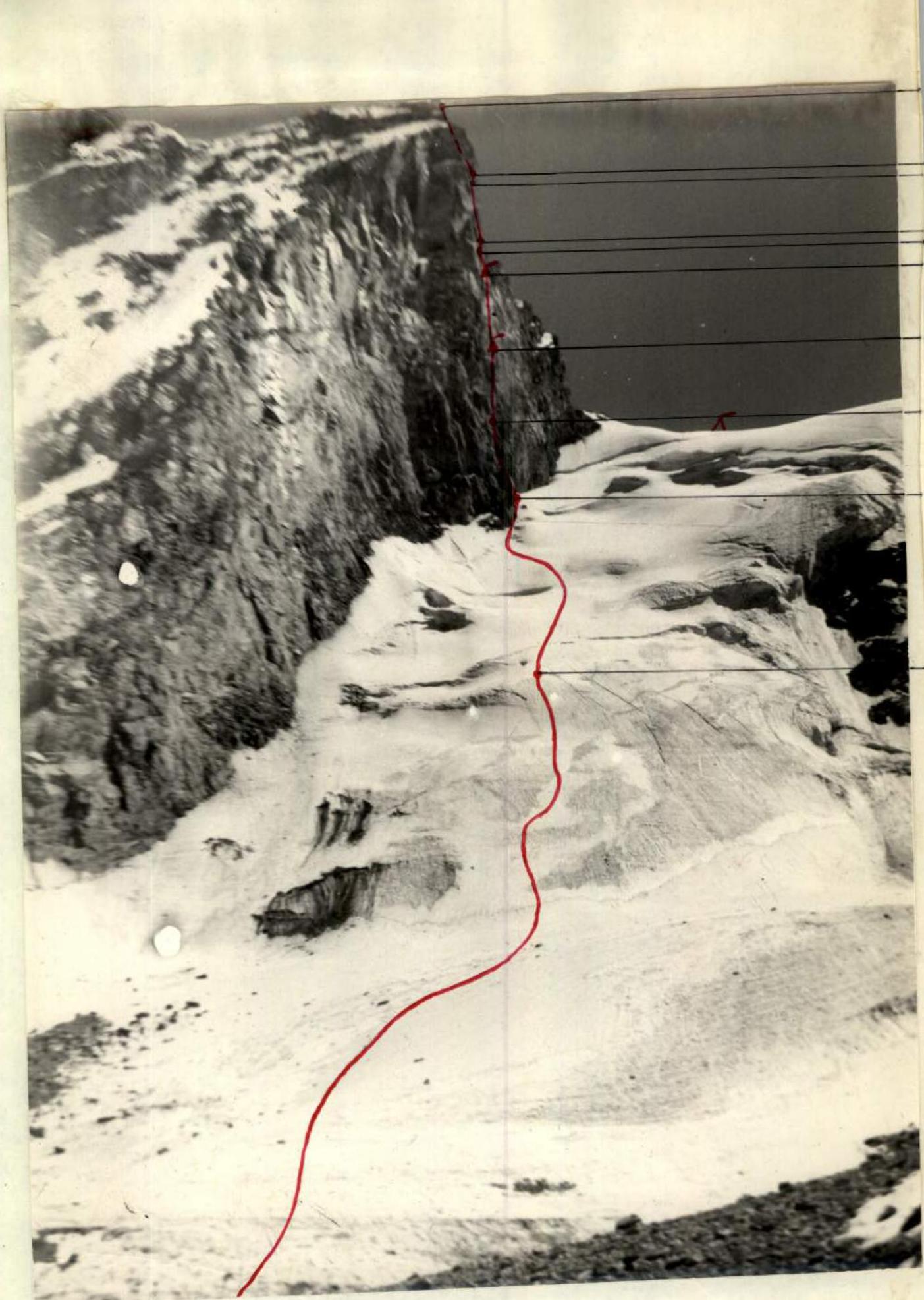
Western wall of peak 5243 m. Path taken by the assault group.
Route description
Peak 5243 m — first ascent
The beginning of the traverse is the ice-rock western wall of peak 5243 m. It is convenient to set up an observation bivouac under the start of the traverse route on the medial moraine opposite the western wall of peak 5243 m.
First, we pass an 800-meter ice-snow ascent (R1–R2), along which we approach to an indistinctly expressed turn of the wall, forming an outer corner.
The ice-snow slope is passed on crampons with the organization of belay through ice screws and an ice axe at the following points:
- at the base of the slope;
- in areas with increased steepness;
- under the нависающей стеной.
Under the нависающей стеной in a snow-filled rantkluft — a place for a comfortable overnight stay.
Sections of the ice-snow slope must be passed in the first half of the day, as stones begin to fall from the roof in the evening.
The beginning of the rock route is a 120-meter wall (R3), consisting of:
- a 40-meter vertical chimney with good holds;
- an 18-meter overhanging wall with protruding blocks;
- further, after a 30-meter diagonal traverse to the left, we ascend along a 30-meter smooth wall with cracks for rock pitons to a small ledge.
This section is made of solid rock. It is passed by complex, intense climbing. The section is completely safe. Stones that fall in small quantities from the roof of the wall at the end of the day fly at a distance of 5–6 m from the wall. Overnight stay again under the wall in a snow-filled rantkluft. Next, you need to go to the right along a diagonal 150-meter ledge (R4). The rocks in this area are loose rock of reddish color. They are passed very intensely and carefully using artificial points of support.
The diagonal ledge leads to a small niche where a sitting bivouac is organized.
Backpacks are pulled up to the niche. From the bivouac site, straight up 80 m of interesting and difficult climbing along a sheer wall with many good holds and cracks for rock pitons (R5).
The niche is small. Control point — hanging bivouac site.
Exit from the niche:
- using artificial points of support through an overhanging 20-meter rock;
- then up and slightly to the right 30 m along an indistinctly expressed ledge;
- further — into the inner vertical corner and up it 30 m.
In this section, backpacks are pulled up.
The inner corner turns into a sheer 80-meter wall consisting of large blocks (R6). The wall is passed using artificial points of support, and further — a small 20-meter leather shelf of easy rocks.
Next, a 155-meter sheer rock wall is passed, leading to a shoulder (R8). On the shoulder — a comfortable reclining bivouac.
From the shoulder, the route goes straight up along a 120-meter wall, consisting of 3 steps (inner corner, chimney, and diagonal slit) (R10). After that, we reach the summit. This section is passed by free climbing. The entire wall route requires a wide variety of pitons.
Descent from the summit to the saddle between peaks 5243 m and 5085 m: first, along a 120-meter pre-summit wall — three rappels, and then along a ledge and a rock ridge leading to the saddle. We descend using artificial points of support, sitting on a rope. On the saddle, there is a comfortable reclining bivouac.
Peak 5085 m — first ascent
From the saddle, the ascent to the summit is made along a simple ice-snow slope on crampons. Length R11 — 350 m.
Descent from peak 5085 m along a rock ridge towards the Vez-Dara Pass.
Peak 4927 m — ascent
From the Vez-Dara Pass along a simple rock and ice-snow 800-meter ridge, we approach a 30-meter protruding tooth of peak 4927 m and ascend to the summit along it (R12). The 30-meter wall section of the tooth is passed by free climbing with piton belay. Having descended from the summit, we pass a strongly destroyed ridge, where we organize a reclining comfortable bivouac.
Peak 4670 m — first ascent
From the bivouac site, we pass a 700-meter rock ridge of simple rocks (R14) and ascend to the summit.
The descent from this peak is made along the southwestern rock ridge, sitting on a rope, to the saddle towards peak 4700 m.
From the saddle along a simple destroyed rock ridge 200 m long (R15), we ascend to the summit.
The descent from the summit is made along the direction of the saddle between peaks 4700–5158 along a rock ridge of medium difficulty.
Peak 5158 m Akmu — first ascent
The ascent to the summit is made along an ice-snow ridge 800 m long (R16–R17). The route is passed on crampons using ice screws for belay.
Descent from the summit along a rock ridge to the saddle in the direction of peak 5150 m using artificial points of support, sitting on a rope:
- 4 rappels;
- 2 sports.
On the saddle, there is a comfortable reclining bivouac.
Peak 5150 m — first ascent
The ascent to the summit is made along an ice-snow ridge 450 m long (R18) on crampons using ice screws for belay. The ridge is passed with step-cutting in some areas.
Descent from the summit along a rock ridge to the saddle in the direction of peak 4980 m.
The descent is made sitting on a rope for 80 m, then — to the saddle.
Peak 4980 m — first ascent
The ascent to the summit along an ice-snow slope 670 m long (R19–R21) is made:
- on crampons;
- using ice screws for belay;
- with step-cutting in some areas.
On the snow slope, consisting of kalgaspor with deep dips, progress was difficult.
Descent from the summit along a rock ridge:
- 3 rappels to the saddle in the direction of peak 4495 m.
On the saddle, there is a comfortable reclining bivouac.
Peak 4495 m — first ascent
The ascent along an ice-snow ridge 240 m long (R22–R23) was made on crampons using piton belay.
The descent from the summit was made along a rock ridge to the saddle, sitting on a rope.
Peak 4960 m — first ascent
The ascent to the summit along an ice-snow 160-meter slope on crampons (R24) using ice screws, and then to the summit, a 300 m rock ridge is overcome (R25).
The section is passed by free climbing using piton belay.
Descent from the summit along a rock ridge — three rappels to the saddle in the direction of peak 5214 m (AKMU).
Peak 5214 m (AKMU) — first ascent
From the saddle, first along a simple 500-meter rock ridge (R26), and then along complex rocks 400 m long (R27), we pass by free climbing and reach the summit. Belay through pitons. Descent from the summit along a complex rock ridge, sitting on a rope, and further to the Desyati Pass towards peak Garmchashma.
Peak 4900 m Garchashma — first ascent
From the Desyati Pass along a 600-meter rock ridge of medium difficulty (R28), and then along an ice-snow ridge 100 m long (R29), we ascend to the summit. Descent from the summit to the Luknitsky Pass along a rock ridge: first, a rappel, and then passage by climbing a simple ridge of destroyed rocks. Bivouac on the Luknitsky Pass — reclining, comfortable.
Peak 5558 m Shpil — first ascent
From the Luknitsky Pass along the northern ridge leading to peak Shpil, the first 300 m of difficult rocks (R30) are passed by free climbing with piton belay. Then a 370-meter ice-rock section leading to the black pre-summit tower (R31).
These two sections are passed by free climbing with piton belay.
On R30, backpacks are pulled up on some sections of the route, on others — we help the climber with a backpack by pulling the participant up by the rope.
At the black tower on an ice-snow площадке — bivouac. Further, a sheer 120-meter rock section of the pre-summit tower, representing an expressed vertical inner corner (R32), is passed. The wall is passed by complex, intense climbing with piton belay, in some places — using artificial points of support. Backpacks were pulled up.
From the black tower, several meters to the left along a 500-meter ice-snow pre-summit ridge, we ascend to peak 5558 m Shpil.
The section is passed on crampons using ice screws and ice axes. Descent along the western ridge to the saddle between peaks 5558 and 5527 along an ice-rock ridge. Bivouac is comfortable, reclining on the saddle.
Peak 5527 m Tri Bashni — first ascent
We ascend to the summit along the eastern ridge, representing sections of rocks, ice, and snow with a total length of 1270 m.
On the ridge sections, due to bad weather, two reclining bivouacs were organized. The route was passed by free climbing using crampons, rock, and ice pitons.
Descent from peak "Tri Bashni" along the ridge leading to the saddle towards the "Garm-Chashma" valley.
On the descent ridge, a reclining bivouac was organized.
Evaluation of the route passed
The traverse route passed by the team is objectively safe, most logical, and technically complex. Throughout the entire route, high and diverse mountaineering skills are required in overcoming rock, ice, snow, and combined sections, correct tactics in successful completion of the traverse, and thorough belaying.
The most technically complex section of the route is the ascent along the 500-meter western wall of peak 5243 m at an altitude of 4700–5200 m and the 120-meter rock section of the pre-summit tower of peak 5558 m Shpil at an altitude of 5000–5400 m.
On the traverse route, mountaineers encountered:
- steepness;
- great length of complex sections;
- significant physical loads;
- mental tension due to altitude.
The traverse route of peaks 5243–5085–4927–4670–4700–5158 AKMU–5150–4980–4495–4960–5214–5558 "Shpil"–5527 "Tri Bashni" all team members evaluate as 6B category of difficulty.
Order of passage of the route by days
1st day. We passed the ice-snow ascent R1–R2 — 800 m. 2nd day. We processed the rock wall R3 — 120 m. 3rd day. We passed the processed section and the diagonal ledge R4 — 150 m. 4th day. We passed the sheer rock wall R5 — 150 m. 5th day. We passed the 80-meter sheer wall of large blocks, a small 20-meter diagonal shelf, and a 155-meter rock wall (R6–R8). 6th day. We passed the pre-summit wall 120 m and reached the summit of peak 5243 m (R9–R10). 7th day. We passed the ice-snow slope and reached peak 5085 m (R11), 350 m. We passed the 800-meter ice-snow slope of peak 4927 m (R12), the 30-meter rock wall (R13), and reached the summit of 4927 m. 8th day. We passed the destroyed rock ridge 700 m long (R14) and ascended to peak 4670 m. We passed the destroyed rock ridge 200 m and ascended to peak 4700 m (R15). We passed the ice-snow 200-meter and 600-meter snow ridge and ascended to peak 5158 m (R16–R17). 9th day. We passed the ice-snow ridge 450 m (R18), ascended to peak 5150 m. 10th day. We passed the ice-snow ridge 420 m (R19–R20), a section of snow and rocks 250 m (R21), and ascended to peak 4980 m. 11th day. We passed the rock ridge 130 m long (R22), the ice-snow slope 110 m long (R23), and ascended to peak 4495 m. We passed the ice-snow slope 160 m long and the rock ridge 300 m long (R24–R25) and ascended to peak 4960 m. 12th day. We passed the destroyed rock ridge 500 m long (R26), the rock ridge 400 m long (R27), and ascended to peak 5214 m Akmu. 13th day. We passed the 600-meter rock ridge (R28) and the 100-meter ice-snow ridge (R29) and ascended to peak Garmchashma 4900 m. 14th day. We passed the rock ridge 300 m long (R30) and the ice-rock ridge 370 m (R31) of peak 5558 m Shpil. 15th day. We passed the 120-meter rock wall of the pre-summit tower (R32) and the snow-ice pre-summit ridge 500 m long (R33) and ascended to peak 5558 m Shpil. 16th day. We passed the rock ridge 700 m long (R34), the ice ridge 230 m (R35) of peak 5527 m Tri Bashni. 17th day. We passed the rock ridge 70 m long (R36) of peak 5527 m Tri Bashni. 18th day. We passed the ice ridge 270 m long (R37) and ascended to peak 5527 m Tri Bashni. 19th day. We descended from peak 5527 m along the ice-rock-snow ridge to the saddle towards the Garmchashma valley and from there to the glacier.
TABLE OF MAIN CHARACTERISTICS OF THE FIRST ASCENT ROUTE First ascent route: traverse of peaks 5243–5085–4725–4670–5158–5150–4980–4495–4960–5214 (AKMU)–4900 (Garchashma)–5558 (Shpil)–5527 (Tri Bashni) m.
Height difference of the wall of peak 5243 m — 1100 m, including complex sections — 770 m, on the traverse — 1490 m. Average steepness of the wall 80°, length of the traverse 10745 m.
| Date | Section | Avg. steep. | Length (m) | Relief | Cat. diff. | Method of overcoming | Weather | Bivouac | Exit | Climbing hours | Rock pitons | Ice pitons | Bolt pitons | Bivouac description |
|---|---|---|---|---|---|---|---|---|---|---|---|---|---|---|
| Peak 5243 m | ||||||||||||||
| 31.07.1975 | R0 | 40° | 800 | Ice ascent | On crampons, step-cutting through ice screws | good | 8 | |||||||
| R1 | 45° | 300 | Ice-snow ascent | |||||||||||
| R2 | 40° | 500 | Ice-snow ascent | On crampons through ice screws | 17:00 | 8:00 | 9 | 6 | reclining in a snow-filled rantkluft | |||||
| 01.08.1975 | R3 | 60° | 120 | Rock wall | 6 | Complex climbing with piton belay | good | 20:00 | 8:00 | 12 | 42 | reclining in a snow-filled rantkluft | ||
| 02.08.1975 | R4 | 60° | 50 | Diagonal ledge | 6 | Complex climbing with piton belay | 26 | |||||||
| R4 | 60° | 95 | Diagonal ledge | 6 | Very complex climbing using artificial points of support | good | 20:00 | 9:00 | 11 | 34 | 2 | sitting | ||
| 03.08.1975 | R5 | 60° | 50 | Sheer rock wall transitioning to an inner corner | 6 | Very complex climbing using artificial points of support | good | 20:00 | 10:00 | 10 | 46 | hanging in a hammock | ||
| 04.08.1975 | R6 | 60° | 30 | Sheer large blocks | 6 | Complex climbing. Piton belay | good | 18:00 | 9:00 | 9 | 22 | |||
| R7 | 30° | 20 | Diagonal shelf | Free climbing | 2 | reclining on a shoulder | ||||||||
| R8 | 60° | 155 | Rock wall | 6 | Complex climbing. Piton belay | 52 | ||||||||
| 05.08.1975 | R9 | 50° | 15 | Shoulder | 1 | Simultaneous free movement | good | 20:00 | 9:00 | 11 | reclining on the saddle between peaks 5243–5085 m | |||
| R10 | 75° | 120 | Inner corner transitioning to a chimney, then to a diagonal slit | 5 | Free climbing, use of artificial points of support. Piton belay | 12 | ||||||||
| Peak 5085 m | ||||||||||||||
| 06.08.1975 | R11 | 25° | 350 | Ice-snow slope | 2 | Passage on crampons | good | 20:00 | 9:00 | 11 | reclining on the ridge between peaks 4725–4670 m | |||
| Peak 4927 m | ||||||||||||||
| R12 | 25° | 800 | Ice-snow slope | 1 | Passage on crampons | 4 | ||||||||
| R13 | 65° | 30 | Rock wall | 4 | Free climbing with piton belay | 2 | ||||||||
| Peak 4670 m | ||||||||||||||
| 07.08.1975 | R14 | 30° | 700 | Strongly destroyed rock ridge | 2 | Free climbing, belay through ledges and pitons | good | 20:00 | 8:00 | 12 | 3 | reclining overnight stay on the saddle between peaks 5158 m and 5150 m | ||
| R15 | 20° | 200 | Destroyed rock ridge | 2 | Simple passage on crampons | |||||||||
| Peak 5158 m | ||||||||||||||
| R16 | 45° | 200 | Ice-snow ridge | 4 | On crampons, belay through ice screws | 4 | ||||||||
| R17 | 25° | 600 | Snow ridge | 2 | On crampons | 2 | ||||||||
| Peak 5150 m | ||||||||||||||
| 08.08.1975 | R18 | 47° | 450 | Ice-snow ridge | 5 | On crampons. Belay through ice screws | good | 18:00 | 8:00 | 10 | 12 | reclining on the saddle between peaks 5150 m and 4980 m | ||
| Peak 4980 m | ||||||||||||||
| 09.08.1975 | R19 | 50° | 300 | Ice-snow ridge | 5 | On crampons. Belay through ice screws | good | 18:00 | 9:00 | 9 | 8 | reclining on the saddle between peaks 4980 m and 4940 m | ||
| R20 | 40° | 120 | Ice-snow ridge | 4 | On crampons. Belay through ice screws | 4 | ||||||||
| R21 | 25° | 250 | Snow. Rocks | 2 | On crampons. Belay through ice screws | 2 | ||||||||
| Peak 4495 m | ||||||||||||||
| 10.08.1975 | R22 | 40° | 130 | Rock ridge | 4 | Free climbing with piton belay | good | 20:00 | 8:00 | 12 | 6 | reclining on the saddle between peaks 4960 m and 5214 m | ||
| R23 | 40° | 110 | Ice-snow slope | 4 | On crampons, belay through ice screws | 3 | ||||||||
| Peak 4960 m | ||||||||||||||
| R24 | 50° | 160 | Ice-snow slope | 5 | On crampons, belay through ice screws | 8 | ||||||||
| R25 | 70° | 300 | Rock ridge | 4 | Free climbing with piton belay | 19 | ||||||||
| Peak 5214 m AKMU | ||||||||||||||
| 11.08.1975 | R26 | 20° | 500 | Destroyed rock ridge | 2 | Simple climbing, belay through ledges | good | 21:00 | 9:00 | 12 | reclining on the saddle between peaks 4900–5558 m | |||
| R27 | 70° | 400 | Rock ridge | 5 | Free climbing, piton belay | 28 | ||||||||
| Peak 4900 m Garchashma | ||||||||||||||
| R28 | 45° | 600 | Rock ridge | 3 | Free climbing, belay through ledges | 5 | ||||||||
| R29 | 40° | 100 | Ice-snow ridge | 3 | On crampons, belay through ice screws | 2 | ||||||||
| Peak 5558 m Shpil | ||||||||||||||
| 12.08.1975 | R30 | 75° | 300 | Rock ridge | 5 | Free climbing, belay through pitons | good | 20:00 | 9:00 | 11 | 25 | reclining on the ice у стены before the tower summit | ||
| R31 | 55° | 370 | Ice-rock ridge | 5 | Partially on crampons, belay through ice and rock pitons | 12 | 21 | |||||||
| 13.08.1975 | R32 | 85° | 120 | Rock wall before the tower summit | 6 | Complex climbing, piton belay, some sections with artificial points | good | 21:00 | 10:00 | 11 | 30 | reclining on the saddle between peaks 5558–5527 m | ||
| R33 | 25° | 500 | Snow-ice pre-summit ridge | 3 | On crampons, belay through ice axes and ice screws | 3 | ||||||||
| Peak 5527 m Tri Bashni | ||||||||||||||
| 14.08.1975 | R34 | 45° | 700 | Rock ridge |