
Ascent Passport
- Ascent class — technical
- Ascent area — South-West Pamir, Shahdarin Range
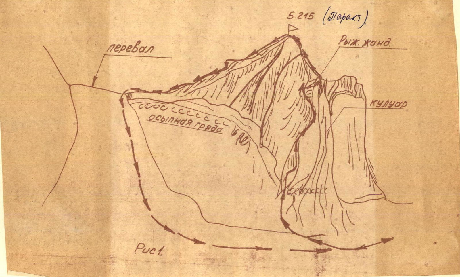
- Summit — peak 5215 m («PARAKHT»), route via the southern 1100 m counterfort.
- Proposed difficulty category — 2B
- Ascent characteristics: height difference, average steepness 50°.
- Pitons hammered: rock — 6 pcs.
- Number of travel hours — 9 h 45 min
- Team name — Sports group of the Kharkov Sports Committee expedition
- Number of overnight stays — bivouac on crampons
- Surname, name, patronymic of the leader, participants and their qualification:
- KUTETSKY V.V. — leader, 1st sports category
- MATVEEV Y.I. — participant, 1st sports category
- TKACHENKO L.I. — CMS
- CHEPELEVA I.P. — 1st sports category
- Team coach — SPESIVTSEV A.E.
- Dates of departure to the route and return: July 30, 1975 from the base camp, July 31, 1975 to the base camp.
5215
(Parakt)
Brief geographical description of the ascent area
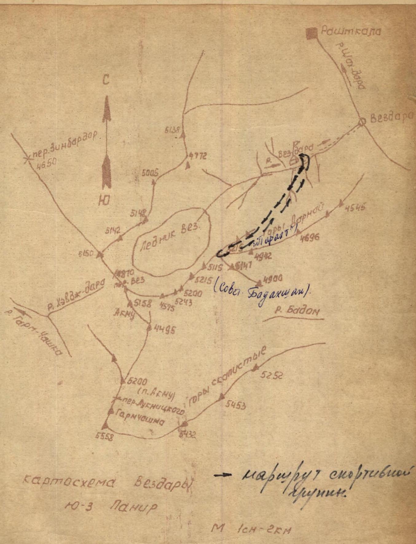
The area of operation of the Kharkov Sports Committee expedition in 1975 — the Viaz-dara river basin, a tributary of the Shakhdara river in the western part of the South-West Pamir.
The South-West Pamir region includes mountain ranges located between the Pyandzh river and the Shakhdara river, forming the Zimbardor-Vakhan range, stretching from the Zimbardor pass to the Shitkhargv pass, and the Shahdarin range, stretching eastward from the Shitkhargv pass.
The slopes of the Zimbardor-Vakhan range are drained by the Tusiyn-dara, Viaz-dara, Badon-dara, Abkharv, and Garm-Chashma rivers. The path to the Viaz-dara river lies through the city of Khorog — the center of the Gorno-Badakhshan Autonomous Region of the Tajik SSR, then — Roshtkala — to the Viaz village, located at the confluence of the Viaz-dara river with the Shakhdara, and then along the trail along the bank of the Viaz-dara river to the mineral spring, located on the left orographic bank.
At this location, a base camp is set up. From it, it is convenient to make ascents to the peaks of the Viaz and Darmay mountain ranges.
Height:
- Khorog city — 2000 m above sea level;
- Viaz village — 2460 m;
- base camp — 3100 m.
The Viaz-dara river area is characterized by a sharply expressed mountainous relief with a large height difference. The snow line is located on average at a height above 4000 m. The glaciation of the area is small and is represented mainly by the Viaz glacier and hanging glaciers located at heights above 4500 m. The Viaz glacier is located at heights of 4000–4800 m and is covered with a thick layer of surface moraine in its lower part.
The characteristic heights of the peaks lie within 4500–5300 m. The climate of the area is mostly dry, hot, with a predominance of sunny days (for the period June–August). The noted features make the Viaz-dara river area very promising for organizing expeditions and making sports ascents of various classes. The slopes of the peaks of the Darmay range, facing the Viaz-dara river, abound in complex wall routes.
The peaks of the Viaz range provide a wide selection for routes of varying complexity, starting from simple ones. In addition to sports ascents, the peaks of the Viaz range can be used for preliminary reconnaissance of wall routes to the peaks of the Darmay range. The peak 5148 m is advisable to use as a sports object.
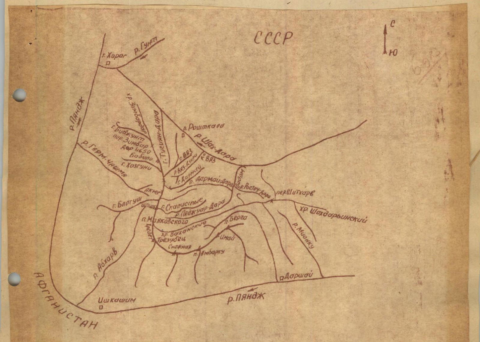
Viaz-dara schematic map. South-West Pamir
Ascent route description
From the base camp along the edge orographic bank of Viaz-Dara to the green stream bed, then up to two large stones, then to the right up through the Viaz-dara tributary and further to the right up steep grassy slopes, following the dry stream bed to the base of the rocky peak, and then along the moraine to the right up, bypassing the rocky peak from the north and further up along the moraine to a steep snow slope (30°, 100 m long) to peak 5215 m (see fig. 1).
From the base camp to the snow slope 4–4.5 hours walking. Ascend the snow slope on the right side (closer to the rock) with an exit to a snow plateau, then to the right up along the plateau 20°, 100–150 m long. Further to the right up along a steep talus covered with snow to the southern counterfort (to the right behind a wide talus couloir). From the snow slope to the beginning of the counterfort 2.5–3 hours. Along the ledges of the black wide inner corner to the left up (insurance is alternating through ledges and pitons). Two ropes up to an inclined right-up ledge 30–40 m long, along which to a нависающий камень (overhanging rock). Then to the left up to the нависающий камень and further along the formed ledges, keeping to the left side (do not enter the couloir! Rockfall hazard!) to the base of the рыжий жандарм (red gendarme), which is bypassed to the left up along the ledges (1 rope, piton insurance). And further to the right up along the inner corner, we exit to a simple snow-rock ridge (insurance is simultaneous), leading to the summit.
From the beginning of the counterfort to the summit 4–4.5 hours. Descent along the southern snow ridge with a detour to the left of the first gendarme and further through the second gendarme (descent from the gendarme along the inner corner) to a snow-rock isthmus, along which we reach the gendarme. Further descent to the south side along a steep snow slope (35–40°, 700 m long) to a snow plateau and further along the ascent path. Descent from the summit to the base camp 3.5–4 hours.
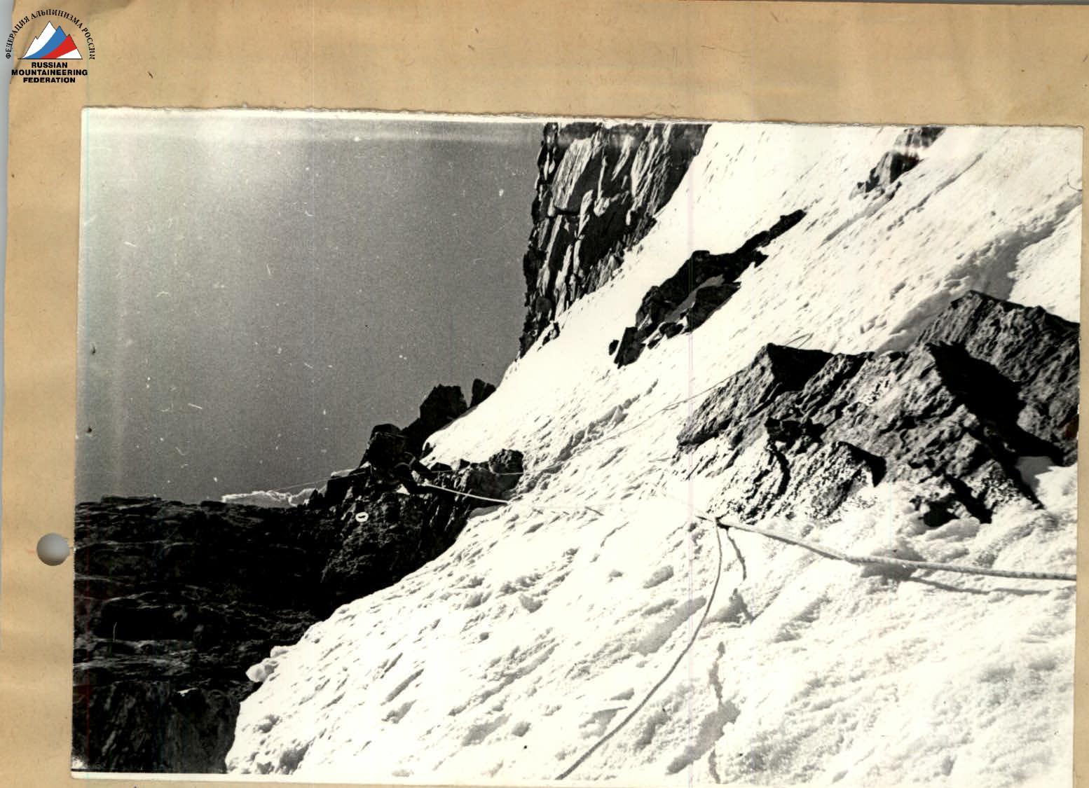
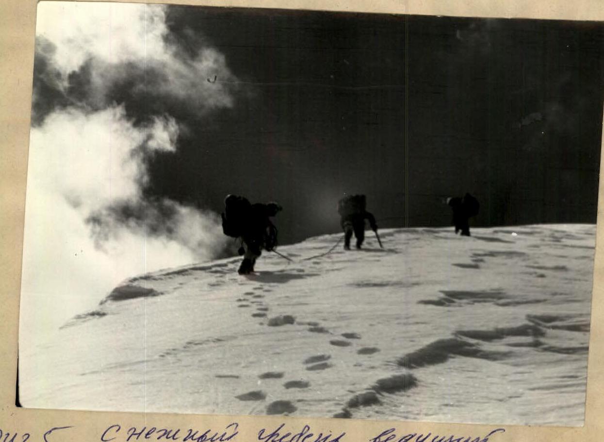
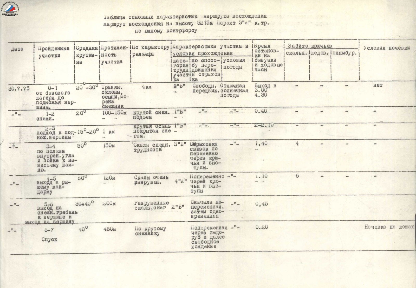
Table of main characteristics of the ascent route to peak 5215 m «Parakht» (3A cat. diff.) via the southern counterfort
| Date | Covered sections | Average steepness | Section length | By relief character | Section characteristics and passage conditions | Time of stops at bivouacs and travel hours | Hammered rock pitons | Hammered ice pitons | Hammered shlymbur pitons | Overnight stay conditions |
|---|---|---|---|---|---|---|---|---|---|---|
| July 30, 1975 | R0–R1 from base camp to the foot of the peak. | 20–30° | 4 km | Grassy slopes, talus, moraine, snow patch. Section difficulty category: 1B | Free movement, excellent sunny weather. | Departure at 3:00. 4:30 | no | |||
| — | R1–R2 snow. | 20° | 100–150 m | Steep snow patch. Section difficulty category: 1 | Ascent | 0:40 | — | |||
| — | R2–R3 approach to the foot of the peak. | 15–20° | 1 km | Steep talus covered with snow. Section difficulty category: 1 | 2:10 | — | ||||
| — | R3–R4 along the ledges of the inner corner and ledge to нависающий камень (overhanging rock). | 50° | 150 m | Rocks, snow patch. Section difficulty category: 3 | Insurance is alternating through pitons and ledges. | 1:40 | 4 | — | ||
| — | R4–R5 exit to рыжий жандарм (red gendarme). | 60° | 120 m | Rocks are very destroyed. Section difficulty category: 4 | Alternating through pitons and ledges. | 1:10 | 6 | — | ||
| — | R5–R6 exit to snow ridge to the summit and exit to the summit. | 30–40° | 200 m | Destroyed rocks, snow. Section difficulty category: 2 | At first alternating, then simultaneous. | 0:45 | — | |||
| — | R6–R7 Descent | 40° | 450 m | Along a steep snow slope. | Alternating through ice axe and further free walking. | 0:20 | Overnight stay on crampons |
Protocol
Protocol of the ascent analysis to peak 5215 m via the counterfort 3A cat. diff. (first ascent)
Present:
- CMS Tkachenko L.N.
- Ascent participants:
- Kutetsky V.V. — leader
- Matveev Y.I. — group member
- Tkachenko L.N.
- Chepeleva I.P.
Speakers:
Kutetsky V.V. On June 30, 1975, at 6:00, the sports group left the base camp. Along the grassy slopes and moraines, at 10:00, they approached the snow slope at 5215 m. At 11:00, they reached the snow plateau and at 11:30 approached the talus covered with snow to the beginning of the route: the southern counterfort (immediately after the wide couloir). Then they made an ascent along the wide black inner corner (along the ledges) to the left up (piton insurance and through ledges) to an inclined right-up ledge and along it to a separate нависающий камень (overhanging rock). Further to the left up to the rock and along the formed ledges to the рыжий жандарм (red gendarme) (do not enter the couloir! Rockfall hazard!). The gendarme is bypassed to the left up along the ledges (piton insurance), then further to the right up along the inner corner to the pre-summit ridge. Along a simple snow-rock ridge (insurance is simultaneous), we exit to the summit. They were at the summit at 15:30. Descent along the southern snow ridge 2B cat. diff. (the gendarme is bypassed from the left along the way) to a snow-rock isthmus. From the isthmus along a steep snow slope to a snow plateau and further along the ascent path.
There are no comments to the ascent participants.
Matveev Y.I. The route should be evaluated as 3A cat. diff. The route is combined, snow-rock. Many inner corners, inclined formed ledges are passed with piton insurance. Since the rocks are highly destroyed on a large part of the route (many loose rocks), this increases the requirements for vigilance, attention, and accuracy of each group member on the route. In total, five rock pitons were hammered on the route. The work of the rope teams was alternating. This route is similar in character to the route to Dzhantugan 3A cat. diff., but is somewhat weaker.
Chepeleva I.P. The ascent along the snow slope should be made a little earlier, not at noon, when it is very hot, i.e., make an approach to the ascent object the day before.
Conclusion
To credit the ascent to all group members and leader Kutetsky V.V.