Ascent Log
-
Technical category
-
South-West Pamir, Shakhdarin Ridge
-
Peak 5214 via the counterfort of the south-eastern wall, rock route
-
Assumed 5A category of difficulty
-
Height difference: 840 m; length: 1065 m; length of 5th category sections: 210 m; average steepness of the route: 57°.
-
Pitons driven:
rock 78/8 chocks 33/2 ice none
-
Number of climbing hours: 11 (days — 2)
-
One overnight stay — on descent from the summit, on the "Four" pass — lying bivouac
-
Leader: Vitaly Grigoryevich Buzmakov — 1st category
Participants:
- Gennady Ivanovich Isachenko — Master of Sports
- Alexey Mikhailovich Nikiforov — Candidate for Master of Sports
- Elena Yuryevna Radina — 1st category
- Dmitry Grigoryevich Suslikov — 1st category
-
Coach: Yuri Mikhailovich Razumov — Master of Sports
-
Departure to the route: July 2, 1985 Summit: July 2 Return: July 3
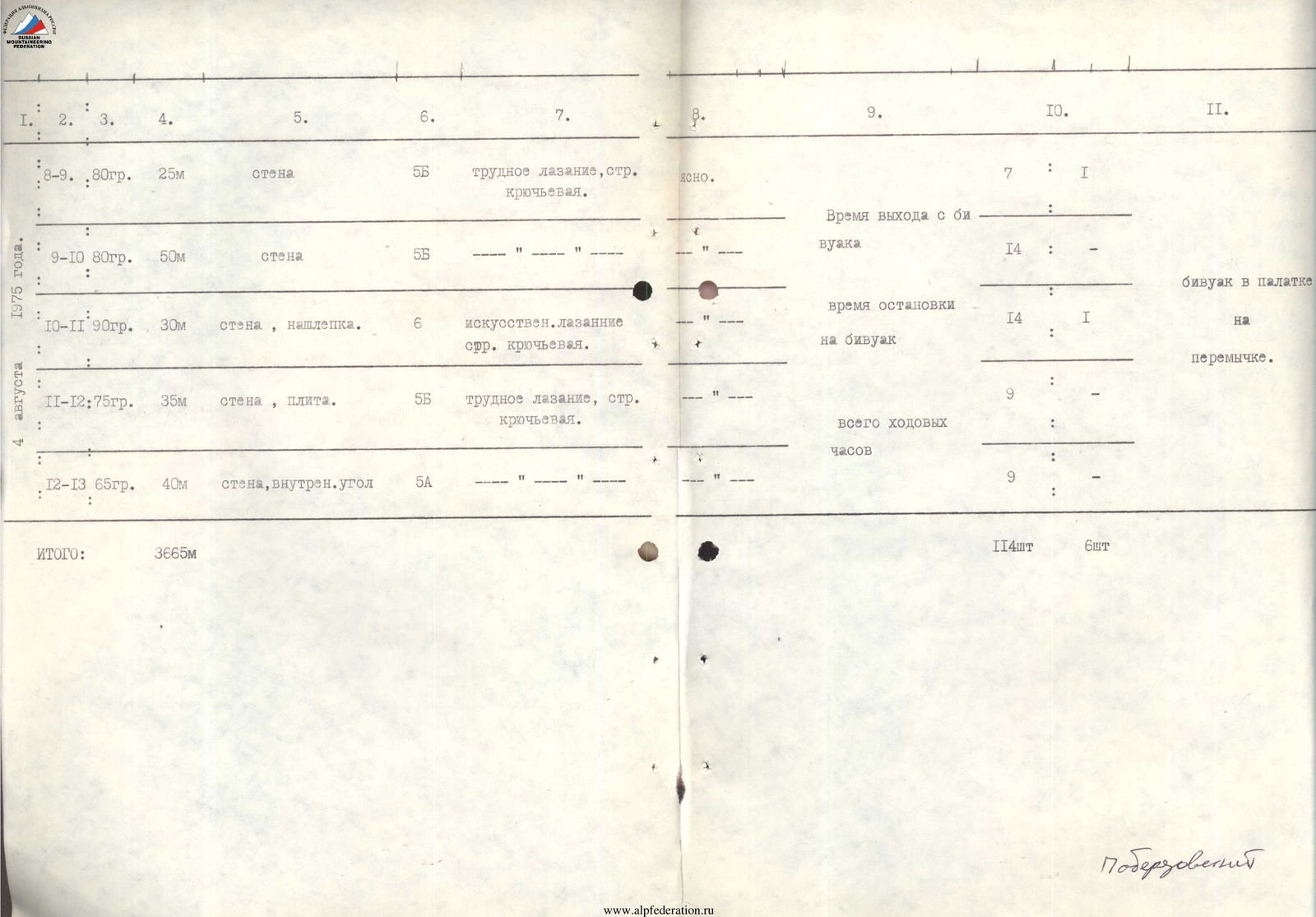
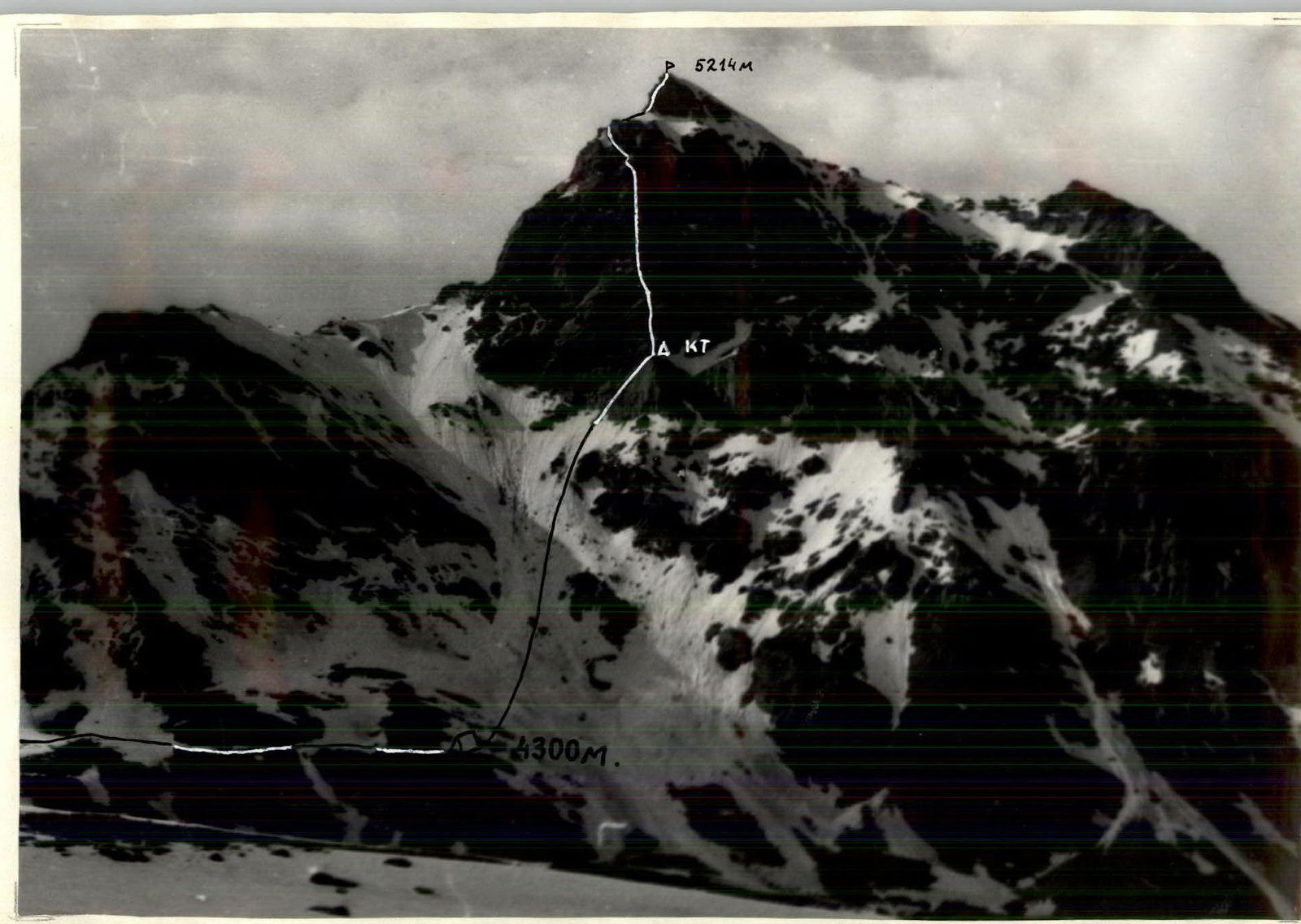
Photo 1. General view of the summit from the north. The picture was taken from the Bijuar glacier. Distance 3 km. Lens "T. 43" 4/40. Shooting point # 1.
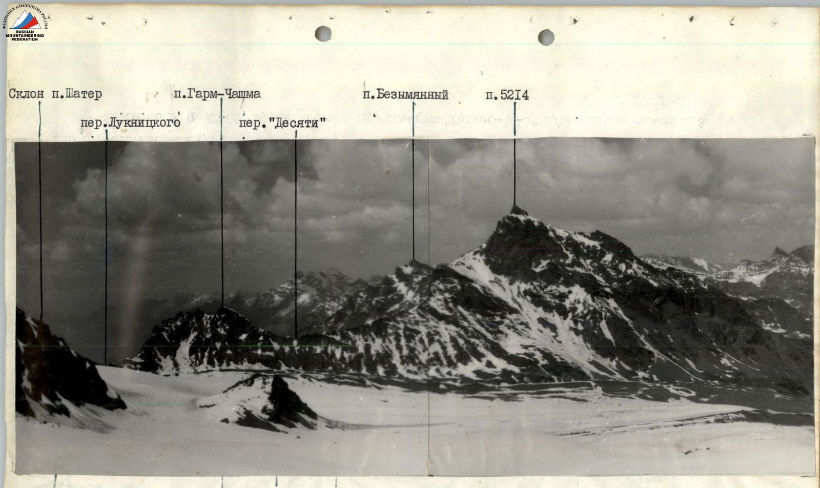
Photo 2. Photopanorama of the area from the north. The picture was taken from the Slavutich pass (V. 4400 m). Distance 4 km. August 8, 1985 at 14:00. Lens T. 43 4/40. Shooting point # 2.
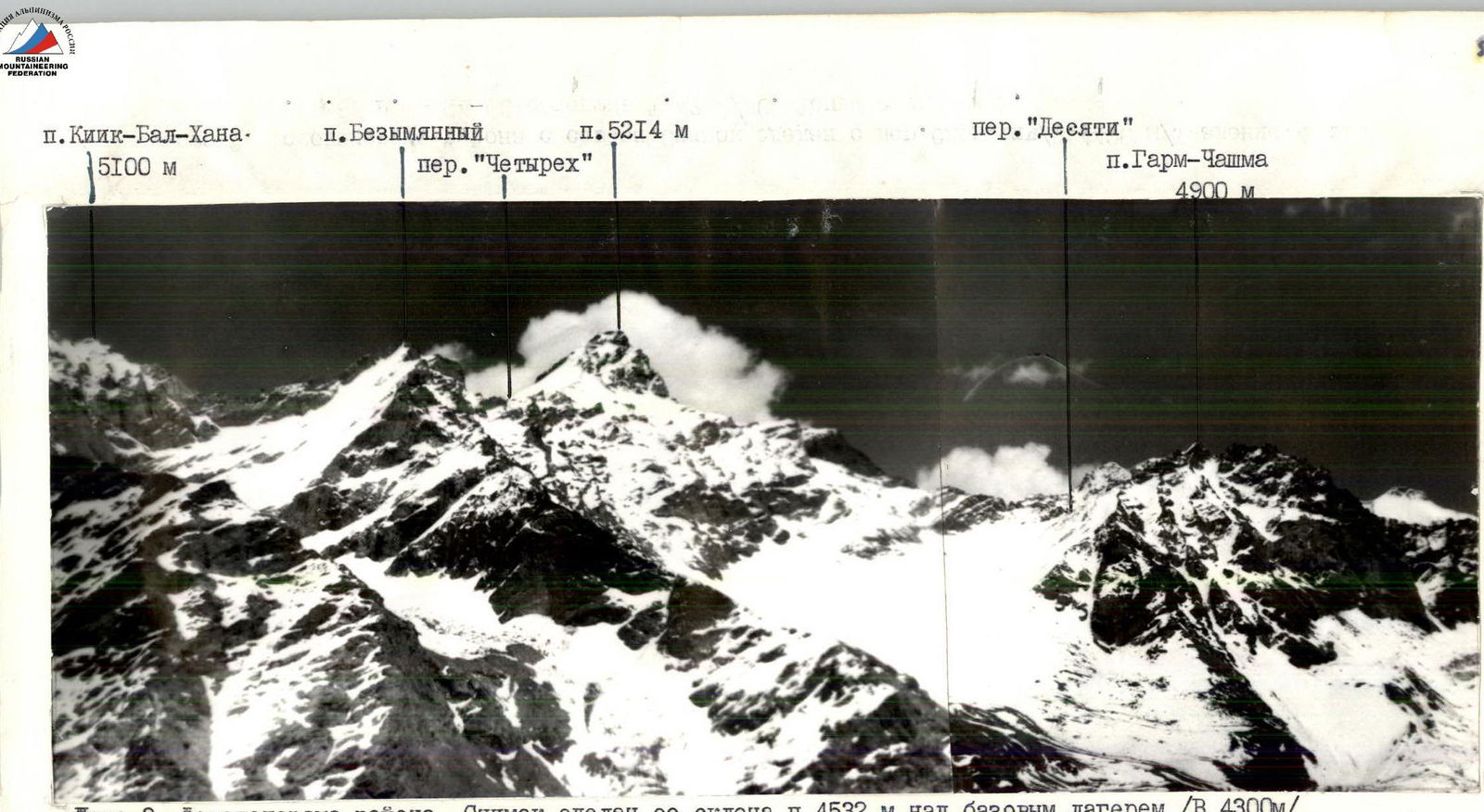
Photo 3. Photopanorama of the area. The picture was taken from the slope of p. 4532 above the base camp (V 4300 m) on June 22, 1985 at 13:00. Distance 8 km. Lens "Helios-44-2" 2/58. Shooting point # 3.
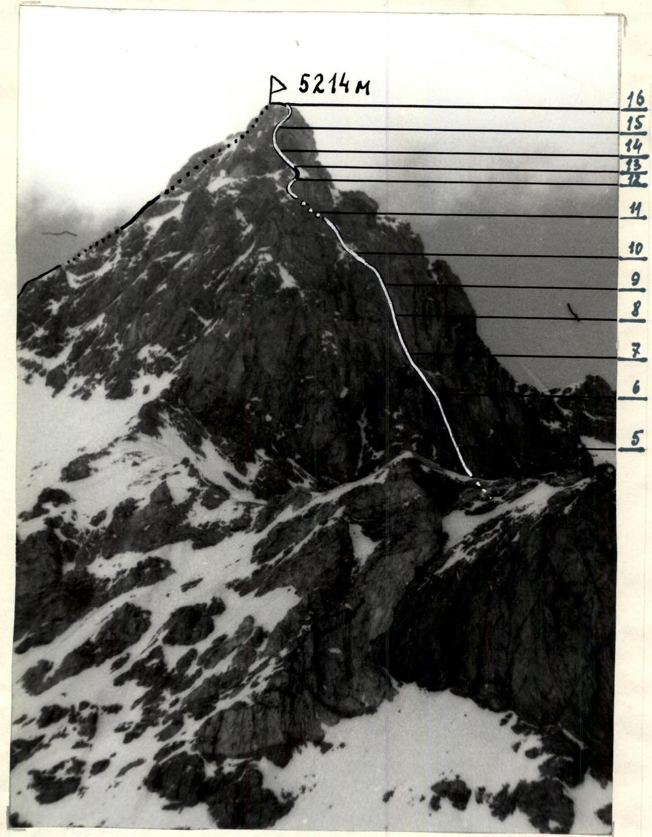
Photo 4. Profile of the SE wall from the left. The picture was taken from p. Garm-Chashma on June 25, 1985 at 16:00. Lens "Helios-44-2" 2/58. Shooting point # 4.
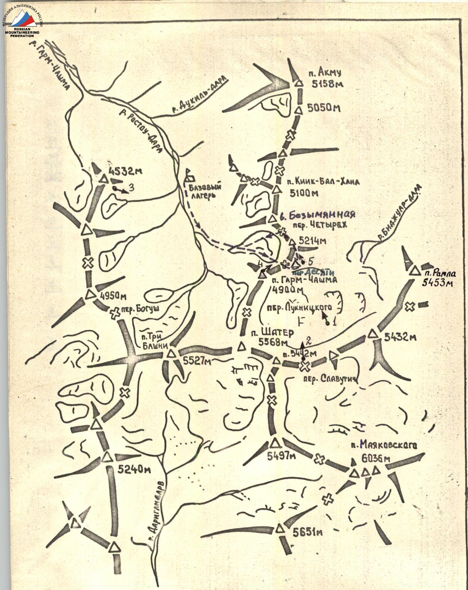
Scale 1:100000
Map of the ascent area
- ▲ — assault camp
- • — shooting point
Brief description of the approach to the route
From the base camp upstream along the right (orographically) bank of the Garm-Chashma river to the point where a stream flows into it, originating from the cirque of the peaks: p. Garm-Chashma, p. 5214, Nameless. Up the stream, leaving the slopes of p. Garm-Chashma to the right, ascent to the glacier and across it to the "Ten" pass.
Through the "Ten" pass, transition to the Bijuar glacier and along the lateral moraine — approach under the South-Eastern wall of p. 5214.
Assault camp — on a leveled site on the lateral moraine opposite the start of the route (approach took 6 hours).
Descent from the summit was made along the North ridge, via route 2B category of difficulty (approximately) to the "Four" pass. After an overnight stay on the pass, descent along the snowy North-West slope towards the cirque of the peaks: p. Garm-Chashma, p. 5214, p. Nameless and further down to the base camp (descent from the "Four" pass to the base camp took 3 hours).
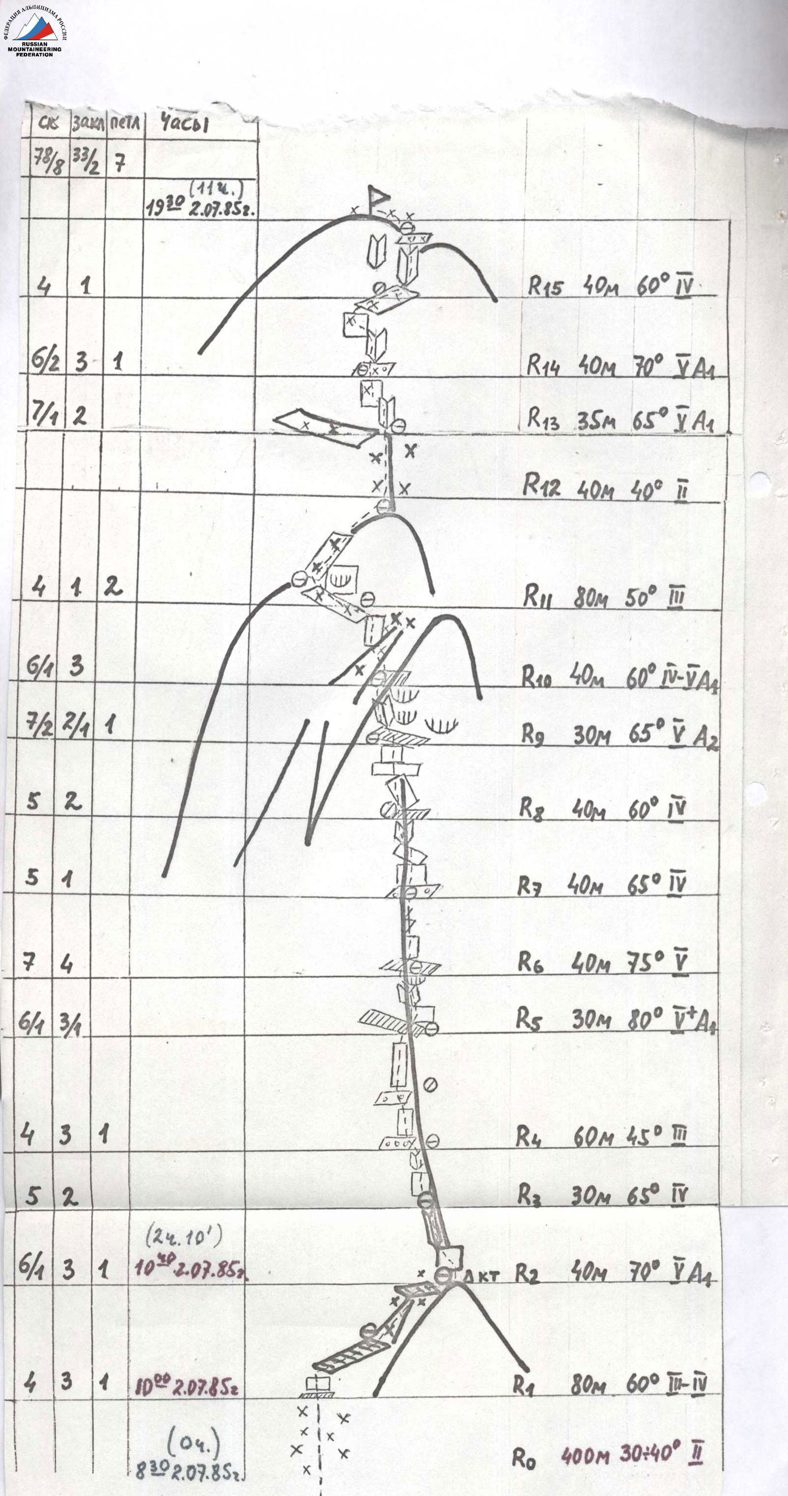
Route diagram in UIAA symbols
Brief explanation of the diagram
Sec. R0–R1. From the assault camp upwards along the snowy slope to the left part of the clearly visible triangular wall, which ends in a counterfort at the bottom.
Sec. R1–R2. Upwards along the gentle, smooth rocks, to the right along an oblique scree shelf to the beginning of an icy couloir, leading to a snowy inclined shelf and further to the top of the triangular wall (control cairn # 1).
Sec. R2–R3. Along the horizontal part of the counterfort (10 m) to a vertical wall (5 m), along the wall from right to left, then along the internal angle to a sharp counterfort.
Sec. R3–R4. Along the left wall of the counterfort, then along the internal angle — exit to a scree shelf.
Sec. R4–R5. Along the scree shelves, overcoming short walls ("live" stones!) — to an inclined shelf.
Sec. R5–R6. Upwards along a vertical slab (7 m), then left upwards along the internal angle (overhang!) — exit to an inclined shelf.
Sec. R6–R7. Upwards along a smooth slab, then along the crack — exit to a scree shelf.
Sec. R7–R8. Left-upwards along inclined shelves, overcoming small walls, then along the internal angle with verglas — to a small shelf.
Sec. R8–R9. Left upwards under the left edge of the bastion — to an inclined shelf.
Sec. R9–R10. Along the destroyed inclined internal angle ("live" stones!) under the overhanging right wall of the internal angle (throws to the left!) — exit to a shelf on the right wall of the couloir separating the bastion from the D-3 ridge.
Sec. R10–R11. Crossing the couloir from right to left upwards along icy rocks (Attention! Fragments of verglas fall from above!) to the left wall of the couloir and, overcoming it, — exit to an inclined snowy shelf.
Sec. R11–R12. Along the snowy shelf to the left, bypassing overhanging rocks — to the shoulder of the D-3 ridge, then to the right along snowy rocks — exit to the snowy ridge.
Sec. R12–R13. Along the snowy ridge — under the summit tower.
Sec. R13–R14. Along the internal angle, left upwards along the wall (7 m) (verglas) — exit to an inclined shelf.
Sec. R14–R15. Along the internal angle, then traverse left upwards along the wall (5 m) (verglas!) — exit to a snowy inclined shelf.
Sec. R15–R16. Along the shelf to the right, then upwards along the icy internal angle — exit to the shoulder of the summit and left along the snow to the summit.

Photo 5. The picture was taken from the assault camp before the start of the ascent on July 2, 1985 at 8:00. Lens "Helios-44-2" 2/58 mm. Shooting point # 5.
Footnotes
-
-
- : 3. 4. 5. 6. 7. 8. 9. 10. II.
-