
- Climbing category - technical.
- Climbing area - South-West Pamir. 46 pc uf 4160518/5-76 pr Daybog
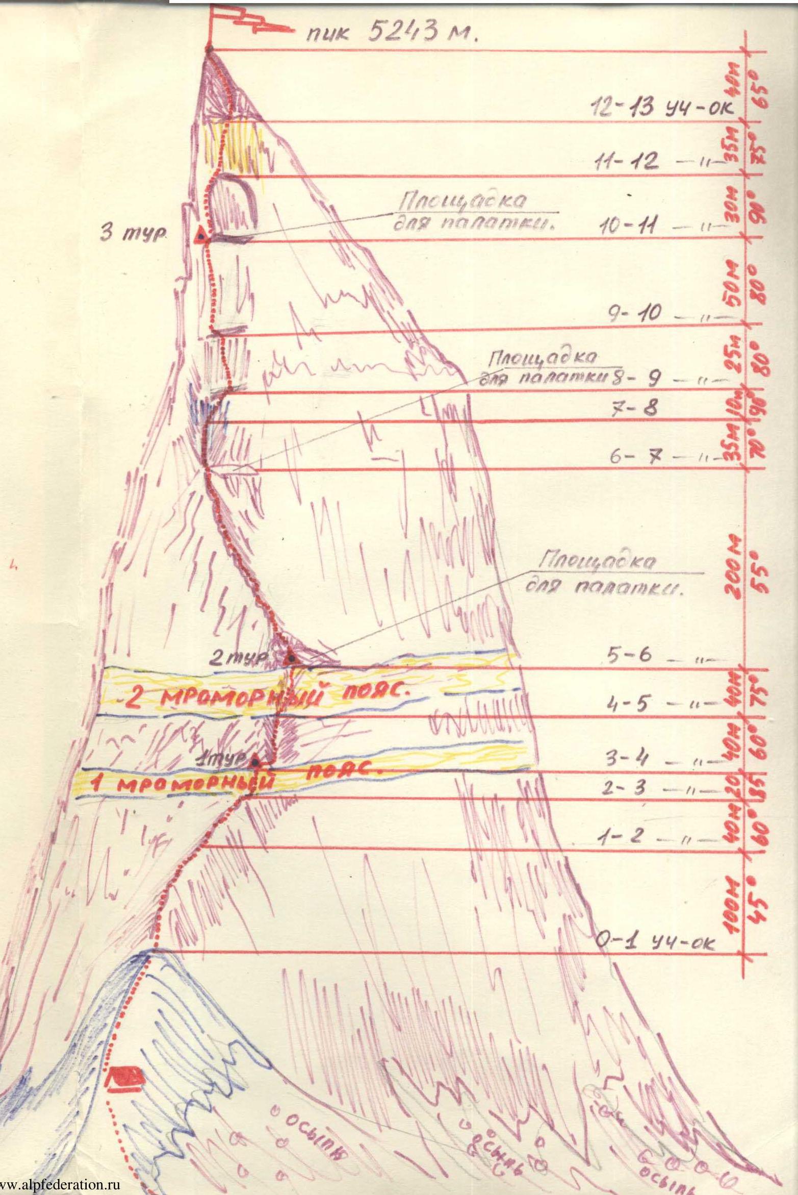
- Ascent route - peak 5243 m via the South-West bastion of the Western wall, ascending to peak 5080 m through the VEZ pass from the Vez-Dara gorge.
- Characteristics of the ascent: height difference - 1345 m, average steepness - 67°, length of complex sections - 365 m.
- Pitons driven: rock - 114 pcs, ice - 6 pcs.
- Duration - 30 hours.
- Number of nights on the route - 2 bivouacs in a tent.
- Team name: Kharkov Regional Council "Avangard" team.
- Surname, name, patronymic of the leader, participants and their qualification:
- Poberezovsky V.I. - leader, Candidate for Master of Sports
- Nagorny S.I. - 1st sports category
- Meleshchenko A.V. - 1st sports category
- Borodich T.P. - 1st sports category
- Team coach: Spesivtsev A.E. - Master of Sports of the USSR, Honored Coach of the Ukrainian SSR.
- Date of departure and return:
departure: August 2, return - August 5, 1975
Brief geographical description and sporting characteristics of the area
The Kharkov City Sports Committee and the Regional Council of the "Avangard" Sports Society organized an expedition in the summer sports season of 1975 to a new area for climbers in the South-West Pamir, in the Vez-Dara river gorge, to participate in the USSR and Ukrainian SSR championships. Our expedition was joined by expeditions from the Ukrainian Sports Committee (Severodonetsk) and Donetsk.
The Vez-Dara gorge is located in the South-West Pamir, 50 km from Khorog - the capital of the Gorno-Badakhshan Autonomous Region, which celebrated its 50th anniversary in 1975.
From Khorog along the Shakhdara river, there are regular buses to the Roshtkala settlement (43 km). 7 km above is the kishlak Vyaz, where the Vyaz-Dara river flows into the Shakhdara river. The Roshtkala settlement has shops, a village council, a collective farm office, a club, a school, a post office, and a hospital. The Shakhdara river gorge is one of the few forested areas of the Pamir. Forests stretch here for many tens of kilometers. In some places, they rise to a height of about 3000 m. An example is the Vyaz-Dara gorge, where significant forest areas can be found in the lower and middle reaches, making it possible to organize a convenient base camp (see photo #2-3). The length of the gorge is about 22 km. In the upper reaches, through the Vyaz pass, one can reach the Garm-Chashma gorge.
The peaks in the Vyaz-Dara gorge have heights of around 5000-5200 m, with the highest point being 5243 m. This peak was conditionally named "Peak Nadezhda" (Hope).
Our base camp was set up near a narzan spring with a water temperature of 25-26 °C, which, according to local residents, is healing. There are about 25 peaks in the area that had not been climbed before our expedition.
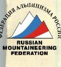
A distinctive feature of this area is the sheer walls, mainly with a western and north-western exposure. Most of them are characterized by the absence of a "roof" with snow, as after the sheer wall, there is a bend and then a descent (see photo #4). Many walls lack sections with snow and water, so climbers need to take snow or water with them on the route.
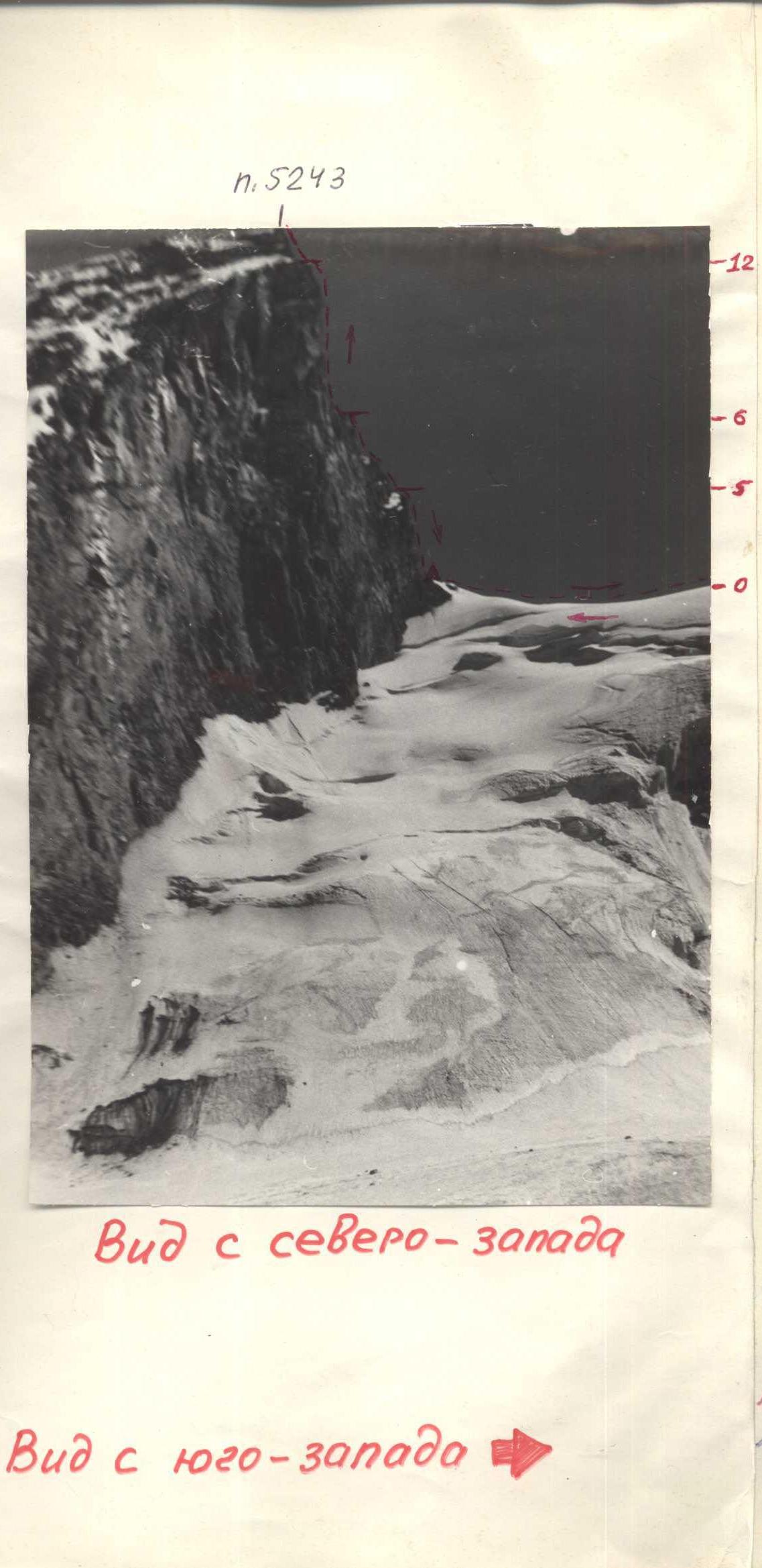
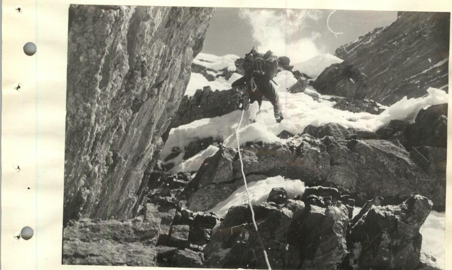
Our object of ascent was peak 5243 m via peak 5080, ascending to peak 5243 m along the South-West bastion of the Western wall. Even from below, a logical and safe path to peak 5243 m is visible from the saddle between peak 5243 m and peak 5080, passing along the 600-meter wall of the South-West bastion, which is overcome mainly by difficult and very difficult climbing using artificial support (see photo #5).
There were no previously climbed routes in this area, so all routes were first ascents.
View from the north-west
 View from the south-west
Photo #4

Photo #5
Description of the route
Peak 5243 m (Peak Nadezhda) is located in the upper reaches of the Vyaz-Dara gorge in the South-West Pamir. The peak 5243 m is the highest point in the area. The view of it opens from the middle reaches of the Vyaz-Dara river. From the Vyaz kishlak to the start of the route, it takes 8-9 hours.
The route to the peak 5243 m passes through the Vyaz pass, peak 5080 m to the base of the 600-meter wall of the South-West bastion, which represents two steep ascents separated by a small flattening where the steepness decreases to 50-55°. The first ascent is intersected by two sheer marble belts, 20-40 m long, which can serve as a good landmark. The route passes through their central part. The second ascent is a monolithic sheer wall with an average steepness of 85°. A landmark is a 30-meter internal angle, turning into a chimney with absolutely smooth walls in its upper part.
August 2. Day 1.
We ascend along the Vyaz-Dara gorge to the moraine of the glacier at the base of peak 5243 m to the observer camp. From here, two expedition members will observe and maintain communication with our team and the base camp. For this, they have two radios:
- "Vitaly" - for communication with the assault group;
- "Karat" - for communication with the base camp.
In addition, the assault group and the observation group have rockets, which, due to direct visibility, can be used to send a signal at any time of day in case of radio failure. For visual communication, the observers have a 30x telescope.
The observer camp is equipped so that it can serve as a relay base for all teams participating in the USSR and Ukrainian SSR championships and for observation groups. There is even a small glacial lake with cold, clear water. The camp is provided with a sufficient amount of food.
August 3. Day 2.
Ascent at 5:00. Departure at 6:00. Along the morning frozen firn, the team reached the Vyaz pass by 8:00. Then, along a snowy slope, sometimes steep, ascent to the western ridge descending from peak 5080 m.
The ridge, initially gentle and wide, gradually becomes steeper and narrower. In the lower part of the ridge, there are scree slopes descending to the south. As the height increases, rocky "gendarmeries" are encountered, which were:
- partly overcome directly;
- partly bypassed on the right.
Climbing is of medium difficulty. In some places, there is rime ice. Belaying is through outcrops and pitons. The summit pinnacle of peak 5080 m was overcome directly.
- The ascent path was determined during a reconnaissance ascent to peak 5080 m along the northern ice wall, approximately 45 category of difficulty, with a descent to the Vyaz pass along the western ridge. The detour around the summit pinnacle was abandoned because:
- to the north, peak 5080 m drops away with sheer rock walls;
- on the steep, very broken rocks of the southern slope, even organizing belays is problematic.
The ascent to peak 5080 m from the Vyaz pass took 4 hours. There is a control cairn on the summit.
The descent from the summit to the saddle between peak 5080 m and peak 5243 m is along a snowy, sometimes icy ridge. At 12:20, we reached the saddle. Bivouac. From here, the further path - the 600-meter wall of the South-West bastion of peak 5243 m - is clearly visible.
At 14:10, the rope team Poberezovsky-Meleshchenko starts processing the first ascent of the South-West bastion wall.
Section R0–R1
From the saddle along the broken rocks of the ridge, 100-110 m in the direction of the central part of the first marble belt. Steepness 45-50°.
Section R1–R2
Along broken, steep rocks, enter through 40 m onto the marble belt.
Section R2–R3
The marble belt consists of monolithic rocks of white color with a small number of cracks and holds. In the central part, it is overcome by difficult climbing along a sheer internal angle. The length of the section is about 20 m. At the top of the belt, there is a hanging control cairn (an ice piton was left).
Section R3–R4
Steep, broken rocks, which are overcome by a small traverse to the right, in the direction of the internal angle of the second monolithic rock belt. The length of the section is 40 m.
The processing of the route on the first day of ascent is finished here. At 19:00, the rope team Poberezovsky-Meleshchenko descended to the tent.
August 4. Day 3.
At 6:00, the rope team Poberezovsky-Nagorny sets out on the route. When ascending along the fixed ropes, clamps are used, which significantly speeds up the passage of the processed section. A little later, the second rope team starts moving, their task being to bring the freed ropes and "hardware" to the leading team.
Section R4–R5
The route passes along the internal angle of the monolithic rock belt, formed by huge blocks. The length of the section is 40 m. Exit to the top of the first ascent. Second control cairn.
Section R5–R6
From the top of the first ascent along strongly broken rocks of the ridge, 200 m to a clearly expressed internal angle at the base of the second ascent. Here is a convenient and safe platform for a possible bivouac.
Section R6–R7
Along a steep internal angle, turning into a sheer, wide chimney with absolutely smooth walls, 35 m upwards. Climbing is very difficult. Rime ice.
Section R7–R8
Along the right vertical edge of the chimney to the right upwards, 10 m, to a narrow ledge.
Section R8–R9
From the ledge along an almost sheer wall directly upwards, 25 m, to a small platform where two people can gather. Climbing is very difficult.
Section R9–R10
From the platform along a vertical wall with a limited number of holds, 50 m directly upwards to a large ledge under the red, smooth wall with an overhanging upper part. Climbing is very difficult. On the ledge, there is a third control point. Possible bivouac site.
Section R10–R11
From the ledge along the left edge of the overhanging slab, after 30 m, exit to the smooth, red wall (mainly on ladders).
Section R11–R12
Along the smooth, sheer wall, 35 m directly upwards, difficult climbing in the direction of a large internal angle.
Section R12–R13
Along a steep internal angle, after 40 m, exit to the summit.
The group reached the summit of peak 5243 m at 15:40. The summit is a pointed spire, on which it is impossible to stand even for one person, dropping away on all sides with sheer walls almost a kilometer high. On the summit, they built a cairn.
Descent - along the ascent route. At 20:15, the group was on the saddle.
August 5. Day 4.
Ascent at 7:00. Descent through peak 5080 m to the Vyaz pass, to the observer camp, and then to the base camp.
Section R0–R0
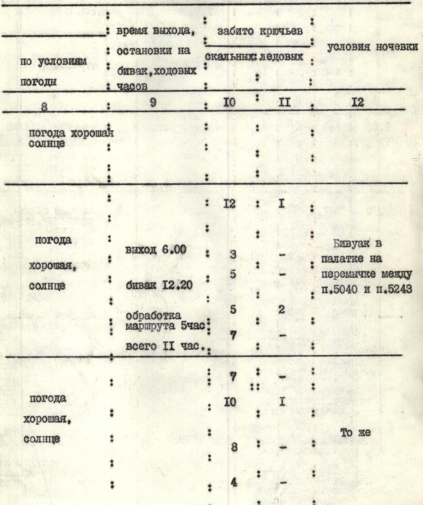
TABLE OF MAIN CHARACTERISTICS OF THE ROUTE
ASCENT ROUTE: peak 5243 m with ascent along the South-West bastion of the Western wall
Characteristics of the section and conditions of its passage
| Date | № | Steepness | Length, m | Relief | Category of difficulty | Characteristics |
|---|---|---|---|---|---|---|
| August 2, 1975 | R0–R0 | 40° | 3000 | slopes, ridges | 3 | medium climbing, mutual belaying through outcrops, piton belaying |
| August 3, 1975 | R0–R1 | 45° | 100 | ridge | 3 | climbing of medium difficulty, piton belaying, through outcrops |
| R1–R2 | 60° | 40 | wall | 4 | difficult climbing | |
| R2–R3 | 85° | 20 | wall, internal angle | 5 | difficult climbing, piton belaying | |
| R3–R4 | 60° | 40 | wall | 4 | difficult climbing, piton belaying | |
| August 4, 1975 | R4–R5 | 75° | 40 | wall, internal angle | 5 | difficult climbing, piton belaying |
| R5–R6 | 55° | 200 | ridge | 4 | climbing of medium difficulty, piton belaying, through outcrops | |
| R6–R7 | 70° | 35 | internal angle | 5 | difficult climbing, piton belaying | |
| R7–R8 | 90° | 10 | wall | 6 | very difficult climbing, artificial support, piton belaying |
ASCENTS
| Weather conditions, sun | Time of departure, stop for bivouac, duration | Pitons driven | Conditions of overnight stay |
|---|---|---|---|
8 | 9 | 10 | |
| Weather good, sunny | 12 | 1 | |
| Weather good, sunny | departure 6:00 | 3 | Bivouac in a tent on the saddle between peak 5080 and peak 5243 |
5 | |||
| bivouac 12:20 | |||
5 | 2 | ||
| route processing 5 hours | |||
7 | |||
| total 11 hours | |||
| Weather good, sunny | 7 | ||
| Same | |||
10 | |||
8 | |||
4 | |||