Team Report
Sverdlovsk Regional Committee for Physical Culture and Sports on the Ascent of Peak Mayakovsky via the NW Wall
Class — High-altitude Technical
| Coach | Mikhailov | A. A. | MS |
|---|---|---|---|
| Captain | Efimov | S. B. | MS |
| Participants | Muravyov | E. A. | MS |
| Pushkarev | V. M. | CMS | |
| Vinogradsky | E. M. | CMS | |
| Piratinsky | A. E. | CMS |
Sverdlovsk
1973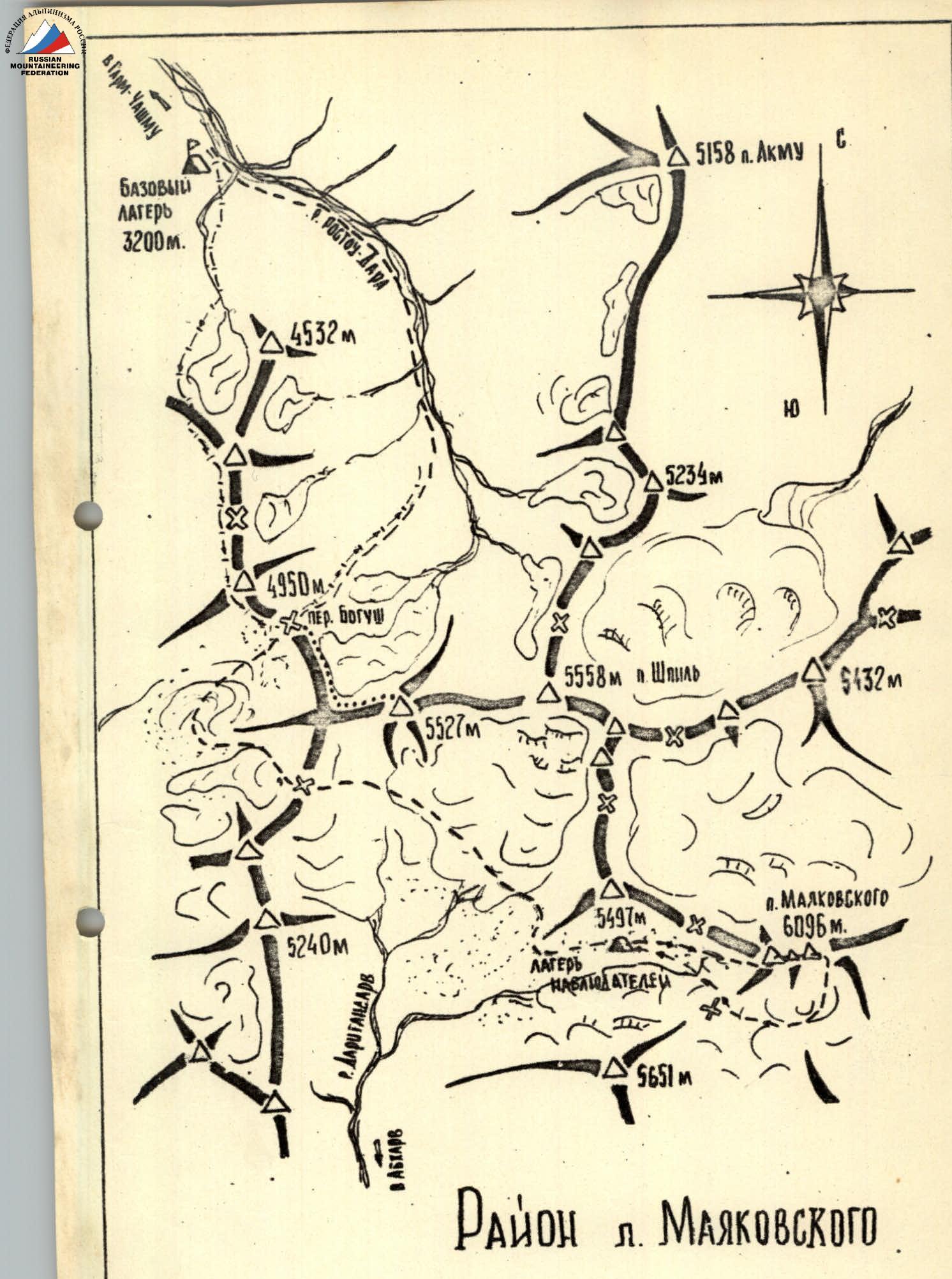
CONVENTIONAL SYMBOLS:
1. Brief Geographical Description and Sporting Characteristics of the Ascent Object
Peak Mayakovsky is located in the Gorno-Badakhshan Autonomous Region of the Tajik SSR, in its western part, at the junction of the latitudinal — Shakhdara and meridional — Ishkashim ranges. It is one of the most beautiful and highest peaks in the area — 6096 m above sea level.
The peak was first mapped on August 19, 1932, and was named in honor of the greatest poet of our era — Vladimir Mayakovsky by Pavel Luknitsky, a researcher of the Pamir region.
Peak Mayakovsky stands out among all the surrounding peaks. However, it can only be seen in its entirety from great heights, from the ridges of the watershed range stretching between the Shak-Dara and Pyanj rivers or other peaks in the upper reaches of the Garm-Chashma river. This is due to the fact that the area is heavily dissected by deep, narrow valleys. The dividing ridges rise above the valley floors by 3000–4000 m or more.
The climate of the area is moderately continental. The average January temperature is –7.8°C, July 22.2°C, with approximately 240 mm of precipitation per year (Khorog). This is the driest region of the southwestern Pamir.
Rivers originate from glaciers or flowing lakes, are very full-flowing, swift, and abound in rapids and waterfalls.
The soil and vegetation cover has features of strong kseroseremia with wormwood, saltwort, and kusinia, and in spring with ephemeral vegetation; in the upper parts, desert-steppe soils with wormwood, feather grass, and thistle; near the peaks of the ridges — cushions (of acantholimon) and patches of meadows with sedges and kobresia. Along the river banks, there are groves of willows, poplars, and jides; on the slopes, rare thickets of juniper.
Wild animals include:
- lynx,
- porcupine,
- wild boar,
- mountain goat,
- marmot.
In the valleys, mainly on the outwash cones of watercourses, there are useful agricultural lands, which are almost fully utilized. On artificially irrigated lands, field crops are grown: barley, peas, oats. Livestock farming is a leading sector of the economy — sheep, goats, cows, and yaks are raised.
There is a sulfur hot spring in the Garm-Chashma village. The water in the "baths" has varying temperatures — from twenty to sixty degrees — near the mouth of the streams. Just above the village, on the left bank of the Garm-Chashma river, there is a narzan spring. The village has a functioning sanatorium.
The area is very interesting in terms of sports. The ridges are crowned with gigantic peaks that abruptly drop into the gorges. Many routes of varying difficulty can be found. So far, the highest peaks have attracted more attention:
- Peak Mayakovsky (6096 m),
- Peak Shpil (5547 m),
- Peak "5527",
- others.
Peak Mayakovsky was climbed several times via more accessible routes before 1973. The southern side, where the large Mayakovsky glacier is located with relatively gentle snow-ice slopes, is the most accessible for ascent.
The ascent from the north is very challenging and possible only via a short ridge branching off to the north from its western peak. The northwest walls are very difficult to pass due to their steepness and overhanging sections.
The beauty of the peak from the northwest side and the inaccessibility of the walls were noted by the first researchers and climbers.
2. Ascent Conditions in the Area
a) Relief Features
The walls on the northwest side of Peak Mayakovsky drop very steeply, dissected vertically by deep, steep couloirs. In the middle part of the wall, there are overhanging glacierets from which waterfalls cascade down during warm periods. The walls themselves are free of snow and ice.
The rock is predominantly gray and reddish diabase marble. In the upper and lower parts of the wall, the rock is weathered, heavily fractured, and there are many "live" stones. Therefore, even when not exposed to sunlight, the wall is often "swept" by falling stones. The middle part of the wall is monolithic with steep, sometimes overhanging sections. The rock is strong. The wall is crossed by several heavily destroyed belts of varying thickness made of weak rocks.
b) Weather Conditions
The weather in the area is quite warm, with many good days in July-August. During our ascent, there were several days when the weather deteriorated in the second half of the day, with strong winds, the upper part of the peak was "shrouded" in clouds, and "graupel" and snow fell.
The high altitude of the peak causes sharp temperature fluctuations both during the day and at night. Therefore, during the ascent, it was necessary to wear down jackets even during the day while moving.
c) Remoteness
The Peak Mayakovsky area is one of the most remote and difficult to access in the southwestern Pamir. In principle, it is possible to reach the western and northwest walls of the peak via three paths, which are almost equally viable:
- The first path is from the Pamir Highway along the Abkharv valley, 45 km long. There is a trail along this valley suitable for pack transport. Transporting goods will require at least two days of caravan travel.
- The second path is through the Lyadzhvar valley under the northern walls and then on foot, bypassing via the "Burevestnik" pass, along a large snowy plateau under the northwest walls.
The third path is through the Garm-Chashma valley. From the Garm-Chashma village, there is a trail for pack transport up the valley for about 25 km, followed by a foot approach under the walls via two passes, 6–7 km.
The terraces under the northwest walls of Peak Mayakovsky have good, flat areas suitable for helicopter landing and setting up a base camp.
Using a helicopter can significantly facilitate and speed up the transportation of goods and people.
d) Exploration of the Area
The first attempts to explore the area, according to available materials, were made in 1904. The honor of being the first researcher of the upper reaches of the Rosto-Dara river and the Garm-Chashma river, down to Anderob, belongs to botanist B. A. Fedchenko. He ascended from the southwest from the Pyanj, from the Kaz-Leu village, through the Bogush-Dara pass. B. A. Fedchenko published a map compiled by his expedition (Proceedings of the St. Petersburg Botanical Garden, vol. 30, issue 1, 1909).
The last pre-revolutionary Russian expeditions to this area date back to 1914. Several routes were laid out in the gorges of the northern tributaries of the Pyanj (Proceedings of the St. Petersburg Botanical Garden, vol. 12, issues 1–6, P. I. Besedin "Trip to Shugnan in the summer of 1914", 1915).
In Soviet times, the area was continued to be researched by both geologists and climbers.
In 1930–1932, P. N. Luknitsky spent a lot of time and effort on research. He deciphered and mapped the tangle of mountain ranges north and east of the Garm-Chashma gorge, discovered several glaciers, large rivers, and several highest peaks, including Peak Mayakovsky.
In subsequent years, the watershed area between the Shak-Dara and Pyanj rivers was well studied by S. I. Klunnikov and A. I. Popov, mainly for geological mapping.
However, the few researchers and travelers who visited here were not climbers, so they did not provide guidance on the most accessible paths to the peaks and descriptions of the glaciers. The high-mountain part of the area remained completely unknown.
In 1947, a mountaineering expedition was organized by the All-Union Committee for Physical Culture and Sports, together with the voluntary sports society "Nauka", led by D. M. Zatulovsky. The expedition included honored masters of sports: E. A. Kazakova (deputy head) and V. P. Sasorov; masters of sports:
- V. A. Budaev,
- A. G. Gromov,
- G. S. Vedennikov,
- V. F. Mukhin,
- and others.
One group of this expedition attempted to find a path to Peak Mayakovsky from the side of the Lyadzhvar river sources. However, the attempt to find a path from the north was unsuccessful: "to the south, the ridge crest dropped off with a steep 200-meter wall..." and the group had to look for a pass elsewhere. The participants of this expedition discovered and mapped a powerful glacier on the southern side of Peak Mayakovsky. From this side, the first ascent to the peak was made, led by V. Budaev.
In 1971, two mountaineering expeditions visited the area: from Kharkov and Leningrad State University. The participants of these expeditions made ascents to some peaks, including Peak Mayakovsky.
Over the time the area has been developed, routes have been laid out to Peak Mayakovsky:
- from the south — 3A category of difficulty,
- along the eastern ridge — 5A category of difficulty,
- along the southwest edge — 5A category of difficulty.
The complex, steep northwest and west walls remained untouched and became the object of our team's ascent for the USSR mountaineering championship in 1973.
3. Reconnaissance and Logistics
The lack of alpinist exploration required additional reconnaissance of the routes to Peak Mayakovsky through the adjacent valleys and ridges.
To this end, in 1971, a reconnaissance trip was made by one of the ascent participants, E. A. Muravyov, and S. Morozov. They ascended on foot from the Pamir Highway along the Abkharv valley to its upper reaches. They explored the ascent route and photographed Peak Mayakovsky and its northwest wall.
As a result of the reconnaissance, it was determined that the 40–45 km path was not very convenient for transporting goods by pack animals. It would take at least two days just to ascend the valley. Considering that pack animals, during June-August, were busy with agricultural work, it was decided not to take this path. The expedition did not have the possibility to use a helicopter as a means of transport.
Therefore, the path along the Garm-Chashma valley seemed the most suitable for approaching Peak Mayakovsky.
From Khorog to Anderob, it is 38 km by car along the Pamir Highway, and another 7 km to Garm-Chashma. There is no further road for vehicles. The details of the ascent path to the upper reaches of the Garm-Chashma valley were discussed with local residents and the previous group of climbers from Kharkov.
On the same day, July 11, 1973, a group of eight people set out to the upper reaches of the Garm-Chashma valley to scout out the location for setting up a base camp and conducting training and acclimatization ascents. On the first day, after a 5-hour hike to the upper pasture and a bit above it, they decided to set up a base camp (3200 m above sea level).
The next day, July 12, 1973, a group of six people, all the main team members, set out to search for approaches to Peak Mayakovsky and study the area. From the "3200" base camp, they entered the first valley (upstream), hoping to find the nearest path to the pass separating the Garm-Chashma and Bogush-Dara valleys. Then, they planned to find a pass point into the Abkharv valley, in the upper reaches of which Peak Mayakovsky is located.
On July 13, 1973, they ascended to the ridge and moved along it in a southerly direction. This path turned out to be challenging, although not very long. They traversed several passes between the Garm-Chashma and Bogush-Dara valleys. On the first pass, they found a note from participants of the 1941 Pamir expedition.
At 12:00, they were on the required pass "4500" near Peak "5527". They decided to leave a cache of remaining food and equipment on this pass and descend to the "3200" base camp down the Rosto-Dara river.
On July 15, 1973, from the "3200" base camp, a group of assistants with pack animals set out to organize intermediate camps:
- at the "Gолубое" lake,
- under the moraines of the Garm-Chashma glacier,
- on the "4500" pass.
On this day, the group reached the "4500" pass.
On July 16, 1973, a group of four assistants descended along a ridge spur towards the Bogush-Dara valley and examined the further path from there to the Abkharv valley. They determined that it was possible to pass through, but it was necessary to descend from the "4500" pass down into the Bogush-Dara valley and then ascend along the moraines again in a southerly direction, bypassing the ridges descending from Peak "5527", and then cross the ridge into the Abkharv valley.
From July 16 to 18, 1973, the main team, consisting of six people, conducted a training ascent to Peak "5527" along the northwest ridge, and once again examined the possible approaches to Peak Mayakovsky from the ridge and the summit.
On July 19, 1973, they set out from the intermediate camp on the "4500" pass under Peak Mayakovsky.
On July 20, 1973, the main team of six people and an observation group of eight people approached under the northwest wall of Peak Mayakovsky. They set up a camp (for observers) on the moraines of the Da-ran-Gan-darv glacier. On the same day, July 20, and the next day, July 21, 1973, they conducted photography and observations of the wall.
On July 21, 1973, at 19:00, a group of six climbers set out from the observers' camp under the route.
4. Organizational and Tactical Plans for the Ascent and Introduced Adjustments
The first reconnaissance of the route was carried out in the summer of 1971 by E. Muravyov and S. Morozov. The northwest wall of Peak Mayakovsky was photographed. Based on the photographs, two route options were preliminarily identified: along the right — western — main route and along the left — northwest — reserve route.
In 1972–1973, descriptions of the area and photographs of Peak Mayakovsky were collected, and a preliminary plan for the team's work was developed:
- July 1 — departure from Sverdlovsk to Dushanbe,
- July 3–5 — travel from Dushanbe to Anderob,
- July 5–8 — setting up a base camp in the upper reaches of the Rasto-Dara Garm-Chashma valley,
- July 9–15 — reconnaissance and training ascent to a nameless peak in the upper reaches of Rasto-Dara 5527 m,
- July 16–17 — approach under the wall of Peak Mayakovsky.
Based on the experience of previous ascents of this type, it was decided to start the ascent without preliminary processing of the route, which practically does not save time in this class of ascents. The working day during the ascent was planned to be 10–11 hours.
This plan assumed enhanced physical preparation (skiing, cross-country running) and especially special rock endurance (continuous climbing on rocks with a steepness of 80–90° for up to 1 hour).
The smooth, steep walls suggested the possibility of hanging bivouacs, so the entire team conducted a series of training sessions on organizing overnight stays on vertical walls. To be able to snack during work on the wall without gathering together (which is difficult on such a route), special individual bags were made for one-time food, which later proved very useful.
One of the route's problems was ensuring the team had water. The wall is completely dry and steep. Polyethylene bags lined with canvas and a 10-liter aluminum canister were prepared. Later, after examining the route from a close distance and identifying potential bivouac sites, it was decided to take only the aluminum canister, which justified itself later.
A forced delay in Dushanbe (the Medvezhiy lake burst into the valley and washed out the Dushanbe-Khorog road) introduced adjustments to the work plan. The first reconnaissance trip was made by a group consisting of: S. Efimov, A. Mikhailov, E. Muravyov, V. Pushkarev, E. Vinogradsky, A. Piratinsky on July 13–14. Then, the same group made a training ascent to Peak 5527 m (5A category of difficulty, presumably) on July 16–18, after which the team of six and a support group of eight people:
- V. Markovsky,
- A. Kargapolts,
- V. Znamensky,
- V. Ryabkov,
- G. Volynets,
- V. Gokhfeld,
- I. Buny,
- S. Mertsalov, approached Peak Mayakovsky.
Observations showed that the Western wall was hazardous due to the melting snow cap and the heavily destroyed upper part of the wall.
The Northwest wall was found to be a strong, monolithic structure leading under the Western peak, and a logical and interesting route in terms of sportsmanship was visible in its right part through the "Tower" — perhaps the only possible option from the entire wall.
The ascent plan was refined and the team composition was finally confirmed:
- July 22, 73 — exit from the camp and passage of the "Tower"
- July 23–25 — work on the wall
- July 26–27 — passage of the ridge
- July 28, 73 — descent to the camp
Later, it turned out that such a plan was indeed within the team's capabilities, and the ridge leading to the main peak was overcome in one day, so on July 26, 73, the group descended to the "4600" camp.
Equipment and Provisions
The equipment used by the team had been repeatedly tested. The route along the northwest wall of Peak Mayakovsky, chosen for the USSR mountaineering championship, can be divided into three main parts by height:
- "Tower",
- "Wall",
- "Ridge".
Vertically, the route is bounded:
- on the left side — by deep, steep walls of a large couloir where all falling stones are funneled;
- on the right side — also by very steep walls, with steep glacierets lying in the upper part, from which ice and stones constantly fall, and during warm times, water cascades down the wall.
The "Tower" and the section one rope length above it represent very weathered rocks, heavily fractured, with unreliable holds: when hammering in pitons and moving along them, pieces break off. Stones fall when pulling the rope.
The Wall represents monolithic rocks with large, steep blocks. Mainly gray and reddish diabase marble.
The ascent to the ridge consists of very destroyed rocks with large step-like ascents. There are many "live" stones on the ledges.
The ridge itself consists of a series of huge gendarmes, with snow-ice cornices hanging on the left side, and dropping off with steep, mostly destroyed rocks on the right side, mostly covered with snow and rime ice. In the ridge depressions, there are snow-ice muldes.
July 21, 1973
A team of six people: S. Efimov, A. Mikhailov, E. Muravyov, V. Pushkarev, E. Vinogradsky, A. Piratinsky, left the observers' camp "4600" at 19:00 under the route of the northwest wall of Peak Mayakovsky. After a 1-hour walk, not reaching the route, they set up a bivouac on the moraines. On this day, they prepared for the ascent and observed the route.
1st Day of Ascent, July 22, 1973
Section R0–R1
At 8:00, they left the bivouac under the Da-rai-gan-darv glacier.
The approach to the "Tower" includes a snow-ice slope, 40° steep, 140 m long. The snow on the slope is pockmarked with stones rolling down during the daytime when the slopes are sunlit (around 11:00–12:00). In the morning, the slope is safe. They put on harnesses, tied in, and began to ascend towards the "Tower". They moved on frozen snow with simultaneous protection, on icy sections with alternating protection. On steep sections, they cut steps.
Section R1–R2
Osspy, light rocks, 50° steep, 200 m long, led them under the base of the "Tower". They moved with alternating protection, laying the rope around выступы. The rocks were местами covered with a layer of ice in the morning. Movement required caution. They reached the "Tower" at 10:30.
1. "Tower"
Section R2–R3
Directly above, giant откопы rise vertically. The upper part of the "Tower" overhangs. They charted a path within sight. Initially, along an internal angle 4 m, 90°, then up and to the right along the wall via indistinctly выраженным ledges.
The rocks are heavily fractured, weathered diabase marble covered with eluvial clay products of weathering. Holds are unreliable, stones fall under load. There are few places to hammer in pitons.
Movement is free. The internal angle is traversed in распорах. The section is 30 m long, steepness 80°.
The first climber goes on a double rope, leaves перила. Other связки work independently.
Section R3–R4
A narrow, наклонная ledge under the overhanging rocks goes slightly to the right and up. In places, the ledge turns into a wall. The rocks are very разрушенные, fractured, but there are few places where a good крюк can be hammered in. Holds are unreliable.
The walls and ledges under the overhanging rocks are traversed маятником on a крюк. Climbing is free. Protection is крючьевая.
The length of the section is 20 m.
Features of the passage:
- The first climber goes without a rucksack.
- The last one also finds it very difficult.
- When выбивке крючьев, it throws away from the rock.
Section R4–R5
The wall, 75° steep, consists of separate vertical стенки up to 3–4 m and small наклонных ledges. Climbing is very complex. The стенки are traversed by free climbing and местами with the use of лестниц. On the ledges, there are many "live" stones. The length of the section is 80 m.
The wall leads to the top of the "Tower". They reached it at 13:30. The location is quite safe and suitable for an overnight stay; a tent can be set up with some effort.
The "Tower" is bounded on both sides by very steep walls, to which couloirs are attached further down. Stones are funneled down these couloirs.
On the northern side, a bit of snow remained on the slope, which was needed.
Above them rose, in the full sense of the word, an enormous wall. From below, under the route, it looked different; the lower part was hidden by the "Tower". Everyone experienced and admired it in their own way. The impression was that the entire 700-meter massif was overhanging. The path was visible, perhaps, in one place:
- there were трещины in the monolithic rocks,
- shallow internal angles,
- which lead under the overhanging rocks.
It was not clear how they could be traversed, but other paths seemed even more complex. Mainly, there were large monolithic blocks of gray, strong marble. The main thing was the hope in the strength of the rocks; the rest was up to their hands and technique.
The processing of the further route was taken up by the связка A. Mikhailov — E. Vinogradsky.
II. The Wall
Section R5–R6
Before the wall, there is a rock gendarme, which is overcome head-on. The rocks are strong, 75° steep, of medium difficulty. They are traversed by free climbing, using small holds and выступы. Protection is крючьевая. The length of the section is 30 m.
Section R6–R7
They move in the direction of the internal angle along the wall, 75° steep. There are vertical стенки 2–3 m — рыжие пояса, composed of separate stones with very weathered fractions, rocks resembling masonry on dry sand. Under load, stones fall out. There is nowhere to hammer in крючья in the пояса. They are traversed by free climbing, very cautiously, smoothly. Крючья were hammered in the intervals between the пояса. The length of the section is 30 m.
Section R7–R8
The internal angle has a smoothed, strong relief, holds are small, strong. It is traversed by free climbing using распоры and заклинивание in щелях. Climbing is very complex.
In the upper part of the internal angle, there are пробки. It is traversed using лестницы.
The length of the section is 5 m.
Section R8–R9
Above the пробки, a ledge under the overhanging wall goes to the left and up. Above it, there is an overhanging monolithic wall. On the ledge, it is thrown off; it is very неудобно to move. For protection and maintaining balance, they used:
- thin швеллерные крючья,
- подхваты under the overhanging rock.
The length of the section is 10 m.
Section R9–R10
Further, there is a monolithic marble wall like "бараньих лбов" with узкими редкими трещинами. The rocks are strong with a small микрорельефом. Climbing is very complex. It is pleasant to move with free climbing. Protection is крючьевая. The length of the section is 35 m, steepness 75°.
At the top of this section, they fixed перила, and the связка descended to the bivouac site. A new связка, S. Efimov and A. Piratinsky, took their place.
The weather is deteriorating. "Крупа" starts to fall, a cold, gusty wind blows.
Section R10–R11
The rocks are of the same character as in the previous section. The steepness increases to 80°. Holds are small; movement is mainly based on трение. Climbing is very complex. The length of the section is 25 m.
The wall ends with a узенькой ledge 5–6 m long under a 100-meter overhanging wall.
Section R11–R12
Further movement is possible only along the internal angle with vertical трещинами; in the upper part, the angle turns into a щель 50 cm wide between the wall and the separated "пером". Steepness is 90–95°. Movement is предельно complex with the use of искусственных точек опоры. This is one of the key sections of the route. There are very few holds; the walls are smooth. In the internal angle, movement is mainly in распорах, using трение. Sometimes it is necessary to move along one of the walls or exit onto the отколу of the overhanging rock. Every meter is gained with great difficulty. S. Efimov moves lightly in галошах, with a set of different крючьев. There are no more free ropes. They had to hammer in two крюка and secure one of the ropes. The other rope is needed for protection during descent. Above, there is an отколу and a wall. After processing the route, S. Efimov and A. Piratinsky descended down to the tent on the "Башне" ridge. Time is 20:00. 200 m of the route have been processed. In the tent, they were waiting with a hot dinner, балыком, treats: орешки, изюм, vitamins.
2nd Day of Ascent, July 23, 1973
At 9:00, the 1st связка leaves the bivouac along the перилам. The 2nd and 3rd связки follow with a 0.5-hour interval to avoid being hit by stones from the upper связки. Each связка works independently.
On the sections, before exiting onto the ledge, they pulled up their rucksacks. From the bivouac, they took a 10-liter canister of water, which they filled from melting snow near the bivouac.
The rocks are cold, covered with frost, the wind is biting. The sun appears on the wall in the second half of the day. Climbing is difficult even along the перилам. They use захваты. Protection is попеременная.
At 13:00, all three связки with снаряжением and rucksacks are on the ledge under the overhanging wall.
The связка S. Efimov — A. Mikhailov move further along the перилам, навешанным yesterday. They ascend without rucksacks, in галошах, with a set of крючьев and ropes. They approach the нависающий section of the "перо".
Section R12–R13
The нависающий section — the exit to the "перо". Movement is along a узкой щели between the wall and the "пером". There are no трещины or holds on the walls. It is traversed on расклинивании. The top of the "перо" represents a наклонную площадку 1–1.5 m².
The length of the section is 5 m, steepness 95–100°.
Section R13–R14
From the площадка, an internal angle (25 m) with a трещиной, расширяющейся кверху, goes straight up. Steepness is 90°. The rocks are smooth, strong. Крючья are hammered into the трещину. Thick крючья and wooden клинья are used. The internal angle is traversed by free climbing in галошах, without rucksacks. Climbing is предельно complex with the use of лестниц.
In the upper part of the internal angle, there is a нависающая пробка, which is overcome directly in лоб on лестницах.
Above the "пробки", a узкая наклонная полка goes to the right and up under the нависающей скалой. The length of the entire section is 40 m.
The полка ends in a нише between the wall and the separated rock. In the lower part, the width of the нише is 0.6–0.8 m, expanding to 2 m at the top.
Here, they decided to set up a bivouac. The last one exited at 20:30. A bit higher, in another нише, a tent was навешена. In it, sitting, four people settled in for the night; two people — in гамаках between the wall and the отколу.
3rd Day of Ascent, July 24, 1973
Section R14–R15
The first связка, S. Efimov and A. Mikhailov, began to work at 9:30. The weather is bad. The sky is covered with тучами; it is cold. From the нише, an internal angle with smooth walls goes straight up (13 m), steepness 80°. The angle rests against a 2-meter карниз; on the right wall under the карнизом, there are 6 small трещины. The ascent is very complex. Up to the карниза, movement is by free climbing, mainly on трении; the карниз is traversed with the use of лестниц. They moved without rucksacks.
Section R15–R16
Further, there are крупные отвесные блоки. On the rocks, there are very few even small holds. Крючья and wooden клинья were hammered mainly between the blocks. Climbing is very complex. The wall ends with a полкой under the нависающей стеной. The length of the section is 10 m, steepness 80%. They pulled up their rucksacks from the bivouac site to the полка.
Section R16–R17
Above, there is a big, high карниз. They decided to bypass it on the right along a узкой наклонной полочке under the нависающими скалами. In places, the полка turns into a wall. Movement is very complex, especially with a rucksack — it сильно откидывает. The first one moved without a rucksack. Protection is тщательная крючьевая. The length of the section is 20 m.
Section R17–R18
The полка transitions into a wall, initially 90° steep, 3 m, then выполаживается to 75°. On the first wall, they повесили лестницу. The rocks are composed of large blocks like "бараньих лбов" made of weathered marble. There are few places to hammer in крючья. Vertical длинные крючья worked well. The нависающая 4-meter wall from the полка is traversed with the use of лестниц, and the rest — by free climbing. The length of the section is 70 m, steepness 75°.
Time is 14:30. The weather has deteriorated significantly; snow occasionally falls; it is cold. However, the rocks are dry; snow does not stick to them because of the strong wind and the steepness and smoothness of the rocks.
Section R18–R19
The route is visible straight up along large, smooth плитам-«перьям» 3–4 m, steepness 85°. Vertical "перья" are traversed by free climbing in галошах. Climbing is very complex.
The length of the section is 10 m.
Section R19–R20
A long internal angle, сложенный отдельными блоками, местами with нависающими стенками. Climbing is very complex. It is traversed by free climbing in галошах. There are two удобных and безопасных points for setting up protection.
The length of the section is 70 m, steepness 80°.
Section R20–R21
They approached under the нависающую рыжую стену. The most suitable path is slightly to the right and up. Initially, there is a vertical, very трудная для прохождения стенка (3 m), then a наклонная узенькая полка, where you can stand with only one foot, going to the right and up under the нависающими скалами. From the end of the полка, there is only one possible path — vertically up along the рыжей стене. This is also one of the key sections of the route.
The wall is сложена из сильно выветренного мрамора with very крупным микрорельефом but few holds. Holds are округлые and not very прочные. There are few places to hammer in крючья. The section is traversed without rucksacks.
Again, "крупа" falls. It is cold. But the wall is dry. It is traversed by free climbing on трение. Climbing is предельно complex. In the upper part of the нависающей стены, when exiting onto a large наклонную полку, they used лестницы. They pulled up their rucksacks. The length of the section is 25 m. The last participant exited onto the площадку at 19:30.
Section R21–R22
The наклонная площадка, 45° steep, 10 m wide, serves as the base of the "окна" — a huge углубления, which from below, from the moraines, looks like a dark square due to the shadows from the боковых нависающих скал.
On this полке, they decided to set up a bivouac. The площадку for the tent was laid out у стенки under the нависающим скальным карнизом, which protected them from falling stones. Organizing the bivouac required effort from everyone; they worked for over an hour.
4th Day of Ascent, July 25, 1973
Section R22–R23
At 9:00, the связка S. Efimov and A. Piratinsky started processing the first верё