Ascent Certificate
I. Technical Grade
- South-Western Pamir, Shakhdarin Range
- V. Garm-Chashma (4900), via the spur of the southern ridge, combined route
- Proposed — Category 3B complexity
- Height difference — 700 m, length — 1350 m, length of sections with category 4 complexity — 160 m, average steepness of the wall part of the route — 55°
- Pitons driven:
rock 34/0, chocks 26/0, ice 1/0
- Number of climbing hours — 10
- No overnight stays
- Leader: Vitaly Grigoryevich Buzmakov — 1st sports category
Team members:
- Elena Yuryevna Radina — 1st sports category
- Dmitry Grigoryevich Suslikov — 1st sports category
- Alexey Mikhailovich Nikiforov — Candidate Master of Sports
- Team coach: Gennady Ivanovich Isachenko — Master of Sports
- Route entry: June 25, 1985
Return: June 25, 1985
12. Collection of LenGorsportkomitet.
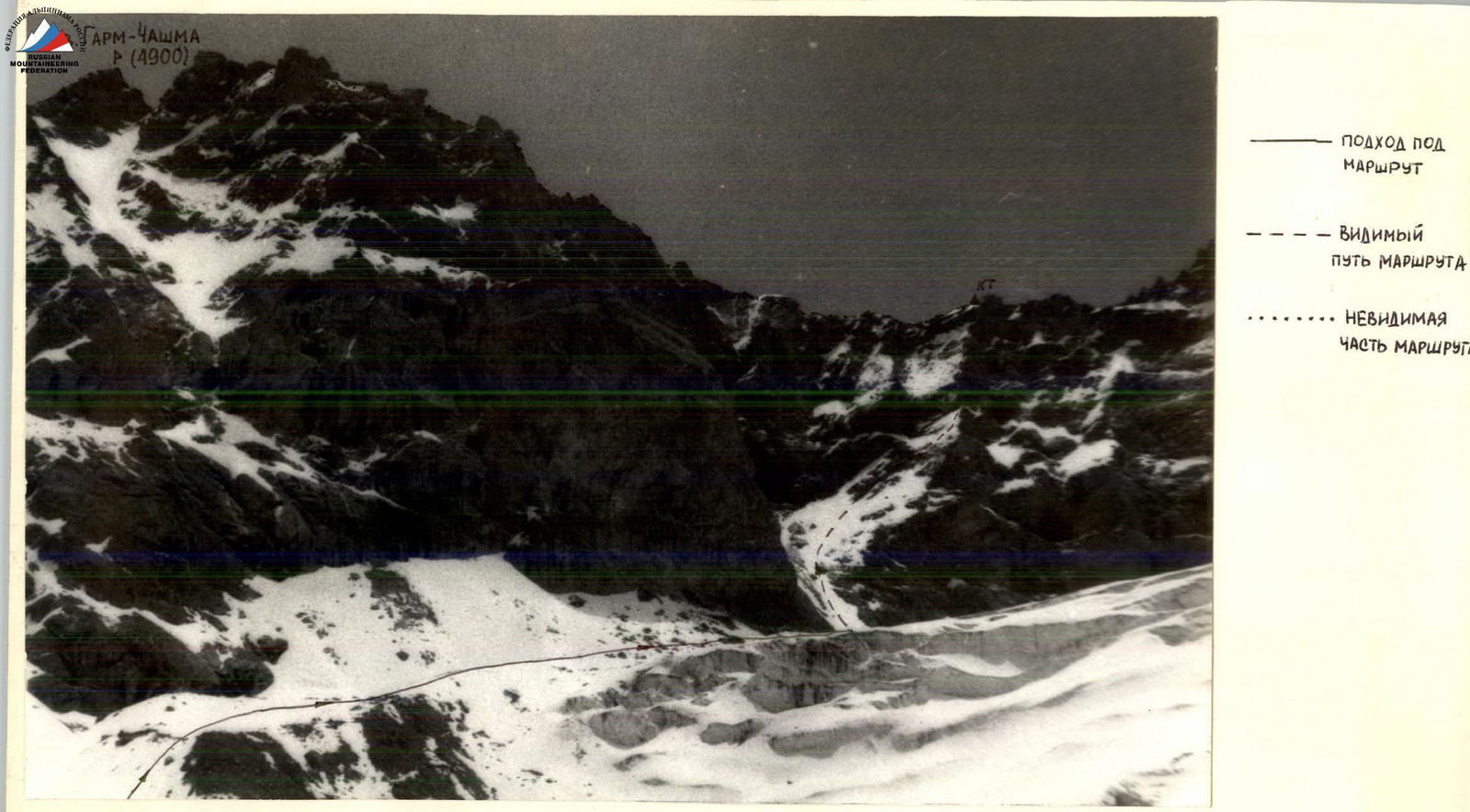
Photo 1. General view of the summit from the west. The photo was taken from the moraine in front of the glacier of the peaks Garm-Chashma and Shater. Distance 1 km. Shooting point #1. Lens T-43 4/40.
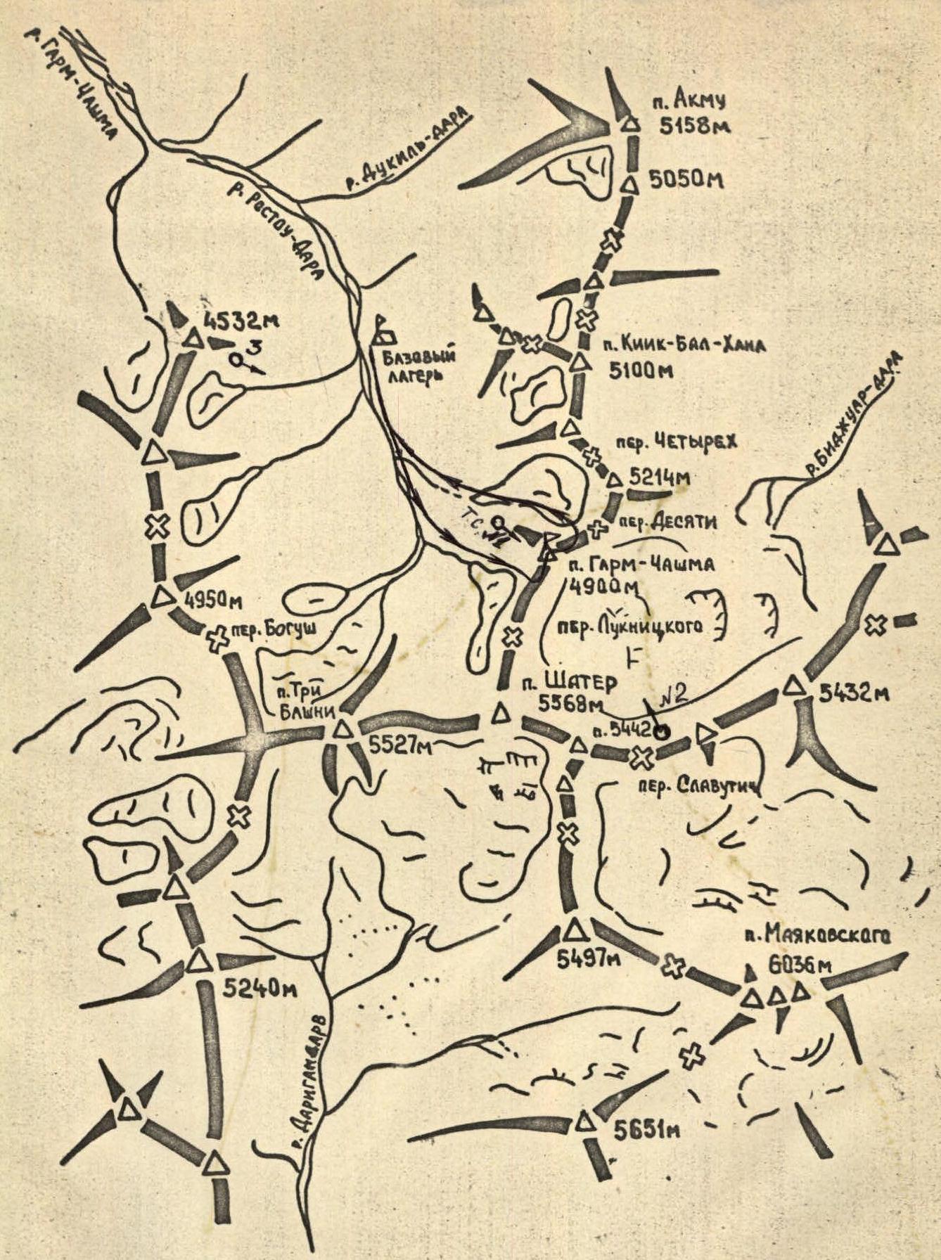
Scale 1:100 000
Ascent Area Map
О — Shooting point
Brief Description of the Approach to the Route and Descent
From the base camp, up the Rastoo-Dara river to the tongue of the Shater glacier. Bypassing the glacier's crevasses on the left, along the moraine, approach to the saddle between Shater and Garm-Chashma peaks to the avalanche cone near Garm-Chashma peak (see photos 3 and 1). From the base camp to the start of the route 3–4 hours.
Descent from the summit first along the rocky ridge towards the "Desyati" pass and then down the snowy slope to the left of the pass into the cirque of peaks 5214 and Garm-Chashma (category 1B complexity). The descent from the summit to the base camp took 4 hours.
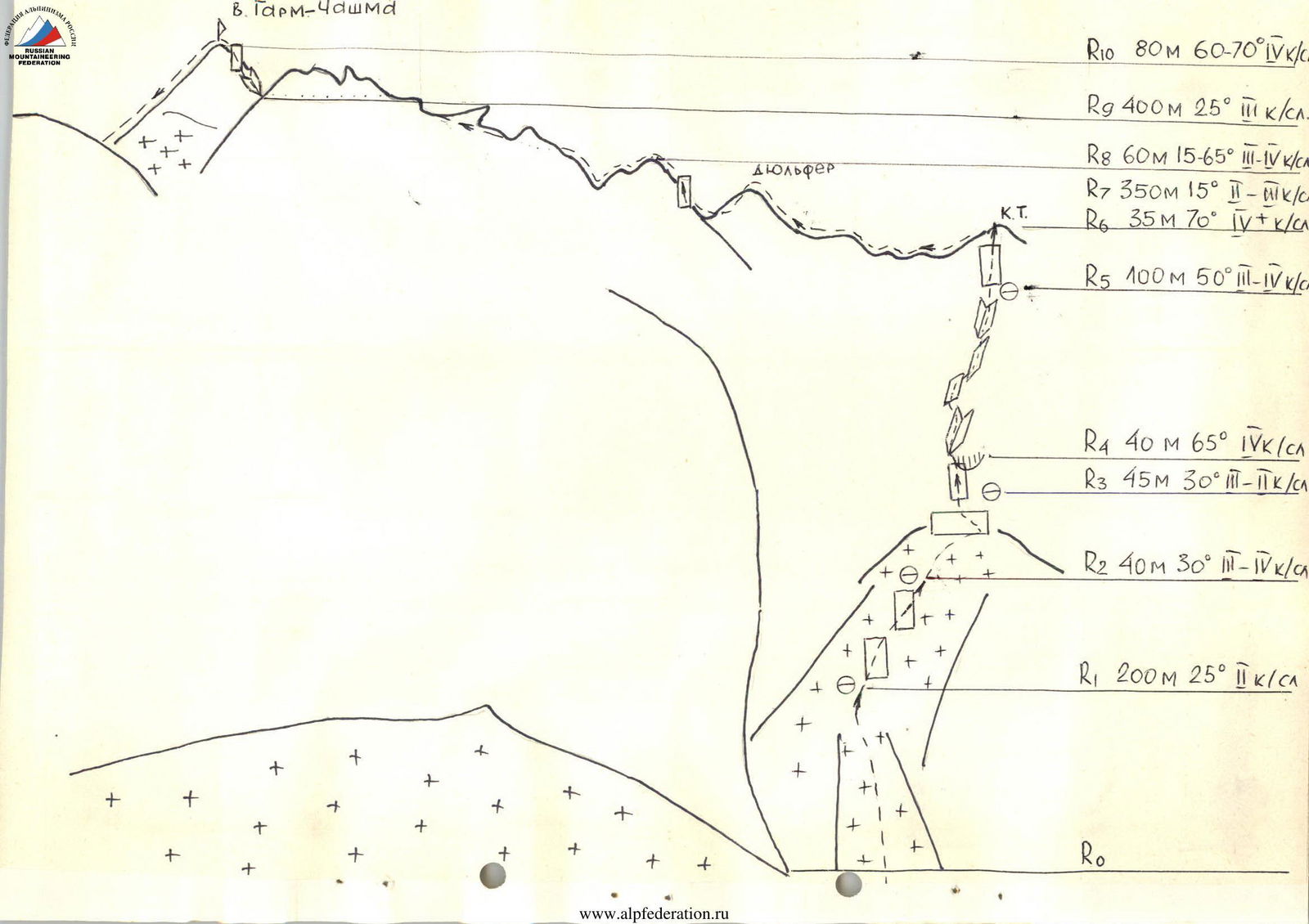
Route Description by Sections
R10 80 m, 60°–70°, category IV complexity R9 400 m, 25°, category III complexity R8 60 m, 15°–65°, category III–IV complexity R7 350 m, 15°, category II–III complexity R6 35 m, 70°, category IV+ complexity R5 100 m, 50°, category III–IV complexity R4 40 m, 65°, category IV complexity R3 45 m, 30°, category III–II complexity R2 40 m, 30°, category III–IV complexity R1 200 m, 25°, category II complexity
Section 0–1. Up the avalanche cone and along the snow-ice couloir to the right, up to the rocky outcrops (section 200 m, 25°–30°, category II complexity). Section 1–2. Along the snow-covered and icy rocks (slabs) to the right, up to the snowy slope (good belay point near a large boulder protruding from the snow), piton belay, rockfall hazard (1 ice piton, 3 rock pitons, 1 chock, section 40 m, 30°, category III–IV complexity). Section 2–3. Up to the end of the snowy slope, exit onto rocks (30 m), good platform (up to this section, it's good to wear crampons), from the platform to the left along a narrow horizontal ridge (15 m) approach to the wall, which leads to the spur of the southern ridge (section 45 m, 30°, category III–II complexity). Section 3–4. The wall is climbed first along a crack to the right, the crack abuts a cornice, bypassing the cornice on the left, transition into a wide crevice, which leads to the spur of the southern ridge (piton belay) (6 rock pitons, 1 chock, 40 m, 65°, category IV complexity). Section 4–5. Along the spur, overcoming a poorly defined inner angle, individual walls, approach under the wall (10 rock pitons, 6 chocks, 100 m, 50°, category III–IV complexity). Section 5–6. The wall is climbed in the center, there are wide cracks for pitons and chocks, the last 5 m are climbed along a large gray slab, the wall leads to the southern ridge, at the exit to the ridge, a control cairn (6 rock pitons, 4 chocks, 35 m, 70°, category IV+ complexity). Section 6–7. Along the ridge, overcoming small walls (3–4 m), bypassing a gendarme to the right, approach to a gap (350 m, 15°, category II–III complexity). Section 7–8. Descent into the gap via rappel (8 m), after the gap, a wall (20 m), the wall is climbed along the left part, in the direction of the inner angle, along the inner angle, exit onto the ridge (3 rock pitons, 4 chocks, 60 m, 15°–65°, category III–IV complexity). Section 8–9. Along the ridge, overcoming small walls, bypassing a gendarme to the right, approach under the summit tower (1 rock piton, 5 chocks, 400 m, 25°, category III complexity). Section 9–10. The summit tower is climbed first along the inner angle, then along the wall, piton belay, channel irons go well (5 rock pitons, 8 chocks, 80 m, 60°–70°, category IV complexity).