
The primacy of the SDSO "Burevestnik" in the class of high-altitude technically complex ascents.
Peak 5435 is located in the Zuluum-Art ridge in the Pamir Mountains. From Peak 5435, a spur runs south, dropping off to the east with a wall. A map of the area is shown in Fig. 1. The sheer eastern wall of Peak 5435 is clearly visible from the Baygashki river valley. The view of the wall from the glacier flowing from the slopes of Peak V. Slutskaya is shown in Photo 1. In its middle part, the wall is fairly simple and gentle, but traversing the wall along this section is not advisable due to frequent rockfalls, making this route extremely hazardous. The right part of the wall is a monolith, gently sloping at the bottom and even slightly overhanging at the top. The left part of the wall consists of three separate rises. The two lower ones are clearly visible in Photo 1.
The overall height of the wall is 450–500 m. After the wall, a fairly gentle, long ridge leads to Peak 5435. The summit itself is snowy.
Group Composition
- Drabkin I.A. Leningrad M-212, Budapeshtskaya ul., d. 23, korp. 2, kv. 17. 1st sports category, leader.
- Danilov A.K. Leningrad, K-17, Zabaykalskaya ul., d. 4, kv. 63. 1st sports category, participant.
- Logchev Yu.A. 1st sports category, participant.
- Andreev G.G. 1st sports category, participant.
The group members completed training ascents to Peak Volodarsky (5600 m) and Peak 5400 m, approximately category 3B and 3A difficulty, respectively. All group members were insured.
Equipment
For the ascent, the group took provisions for 2.5 days, 0.5 liters of gasoline, a "Febus" type stove, and specialized equipment according to the following list:
- Down jackets – 4 pcs.
- Down sleeping bags – 4 pcs.
- Tents – 1 pc.
- Main rope 40 m – 2 pcs.
- Auxiliary rope 40 m – 1 pc.
- Titanium rock pitons – 25 pcs.
- Shvellers (U-shaped pitons) – 4 pcs.
- Carabiners – 20 pcs.
Route Description
(A copy of the description was sent to the classification committee)
Day 1, July 11.
From the base camp, ascend along the stream flowing from the slopes of Peak V. Slutskaya, then along the scree to the glacier, and, crossing the glacier, reach the moraine under the eastern wall of Peak 5435. Overnight on the moraine. 3 hours from the base camp.
Day 2, July 12.
Start the route at 8:00 AM. Proceed as lightly as possible, leaving down sleeping bags at the overnight spot. Initially, ascend a chimney 40 m. At the top of the chimney, there is an ice wall 4 m high (Photo 2). 3 pitons were hammered in during this pitch. Then, exit to the right wall of the chimney and ascend the wall 90–100 m with piton protection (8 pitons), Photo 2. Reach the shoulder of the first rise (control cairn). Next: — ascend leftward 40 m along heavily broken rocks, exercising caution to avoid dislodging stones (2 pitons); — traverse leftward along the wall (Photo 3), 30 m (4 pitons), and reach an inclined ledge trending left and upward; — two pitches along the ledge (4 pitons), Photos 4, 5. Next: — ascend a narrow gully, 2.5 pitches (10 pitons), (Photo 3). At the end of the gully, opposite a cave, there is a second control cairn. Next: — ascend more gentle rocks, interrupted by walls 8–10 m high, which are climbed (Photo 3), 2 pitches — 6 pitons; — exit to the ridge and traverse it for 2 pitches to the third rise, with protection via ledges. Overnight under the third rise. 10 hours of climbing.
Day 3, August 13, 1953.
The third rise is climbed initially along a ledge to the left, 40 m (2 pitons), then another 40 m upward along the wall (5 pitons), and exit to the south ridge leading to the summit. Along the ridge, about 12 pitches on rocks of moderate difficulty with minimal height gain (Photo 3). Numerous rock pinnacles, 10–15 m high, are overcome: — directly; — or bypassed on the left. 4 pitons were hammered in on this section. Protection is mostly via ledges. The summit of Peak 5435 is snowy; 2×40 m on steep snow under a small snow cornice; breaking through the cornice — exit to the summit. Descent: — down to the end of the third rise — via the ascent route; — then rightward down steep snowfields and scree on the south ridge to the glacier; — along the glacier — to the overnight spot, 6 hours of climbing. Then descend to the base camp.
Route Recommendations
The group considers the completed route to be category 5A difficulty and recommends it for groups with experience in high-altitude ascents. Most suitable for the route are: — pitons 10–15 cm long and 4–5 mm thick; — shvellers.
Shvellers are very convenient to use.
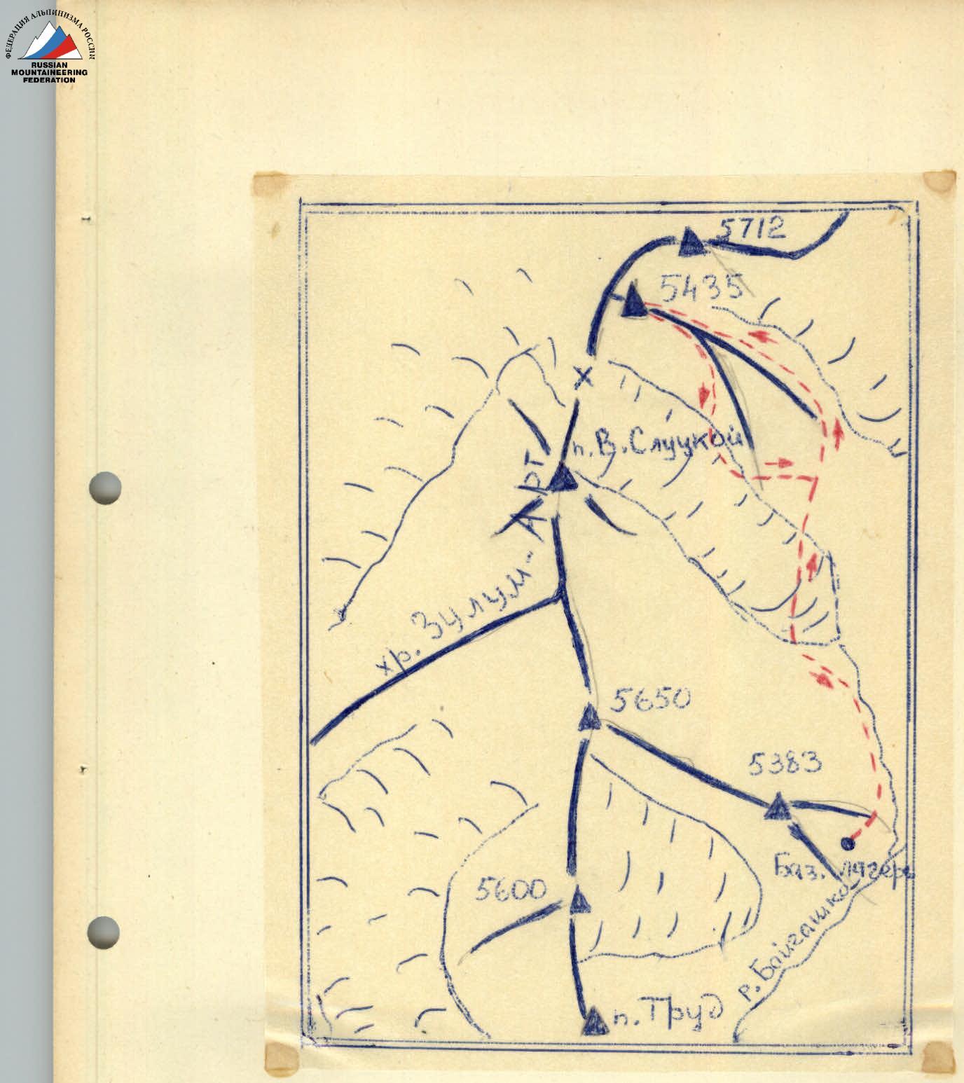
Fig. 1
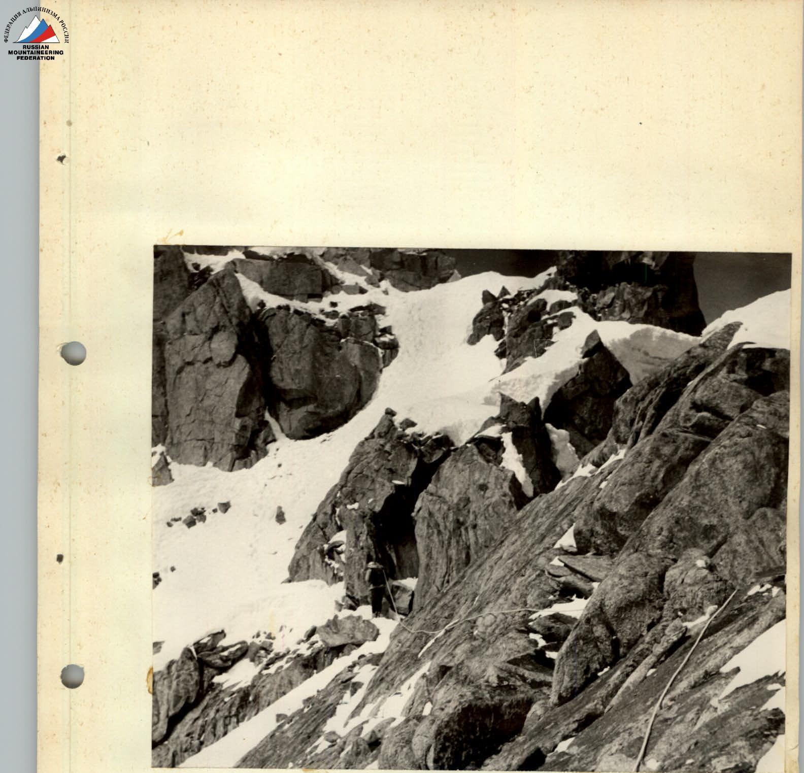
Photo 5