
TRAVERSE OF PEAKS:
- «5100 m»
- «5200 m»
- «5340 m»
- «5689 m (Egorova V.P.)»
- «5900 m»
- «RAZDELNAYA»
- «LENINA 7134 m»
- «Lipkin ROCK» Cat. 5B, for the Spartacus Championship of the Central Council of the DSO in 1970.
High-altitude Pamir gathering of the Spartak UzSSR team at the Vysotnik alpine camp from July 25 to August 22, 1970.
Trans-Alai Range, Vysotnik alpine camp 1970.
Main characteristics of the ascent
 We've completed
S-3, ahead of the planned expedition
We've completed
S-3, ahead of the planned expedition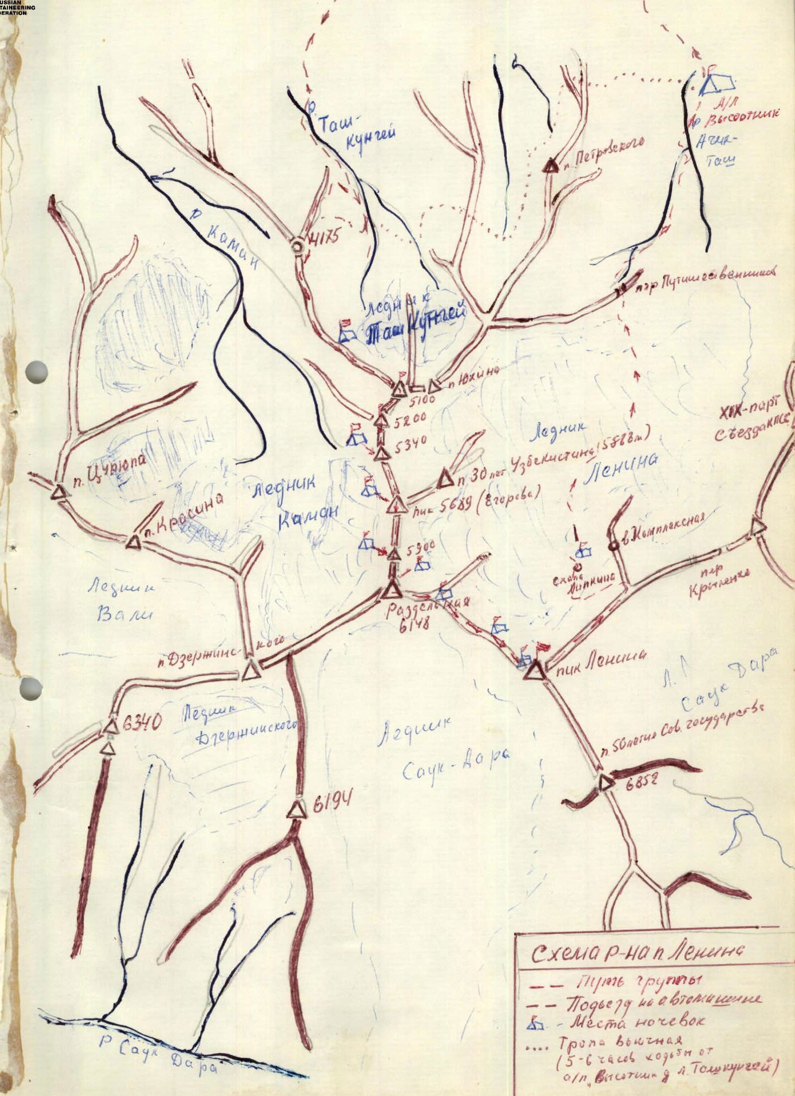
I. Goals and objectives
The team had the following tasks:
- High-altitude training for the team
- Improving the sportsmanship of team members
The main goal of the team was to participate in the Spartacus Championship of the Central Council of the DSO in the class of high-altitude ascents and traverses.
II. Geographical overview and mountaineering characteristics of the region
N.V. Fedchenko discovered an unknown peak in the Trans-Alai Range in 1871, estimating its height to be 7620 m. The researcher named it after P.K. Kaufman.
In 1928, the peak, which was considered the highest point in the USSR at the time, was renamed after the revolutionary leader V.I. Lenin.
The same year, the peak was conquered by three members of the Soviet-German expedition - Alleyne, Wien, and Schneider.
On September 8, 1934, the first Soviet ascent was made: K. Chernukha, V. Abalakov, and I. Lukin installed a bust of V.I. Lenin at the summit.
Lenin Peak is located in the middle part of the Trans-Alai Range and is its main peak. The peak is connected to Dzerzhinsky Peak (6713 m) on the west and to the ridge of Yedinstva Peak (6673 m) on the east via the Krylenko Pass (5820 m).
To the south, in the spur of Lenin Peak, lies the peak "50th Anniversary of the Soviet State" (6852 m).
The Lenin Peak massif consists of:
- Limestones
- Shales
- Sandstone
The peak is visible from any panoramic point in the Eastern and Southwestern Pamir and the Alai Range.
The Trans-Alai Range forms the northern boundary of the Pamir. To the east lies the "Zarya Vostoka" peak (6346 m). To the right is the massive "Kurumdy" (6610 m).
- "Pограничник" Peak (5434 m)
- "Gory Korzhenevskogo" (highest point of the ridge - 6075 m)
- The giant peak "Kyzyl-Agyn" (6679 m)
- "Barrikady Range"
- Lenin Peak (7134.3 m)
- To the west - Dzerzhinsky Peak (6713 m)
- Krasin Peak (5996 m)
- Tsurupy Peak (5845 m)
- Sverdlov Peak (5451 m)
Relief and geological structure
The steep slopes of the Trans-Alai Range are cut by a system of short, wide valleys, which are closed by nearly vertical walls of cirques. Numerous glaciers descend along the valleys.
The northern slope of the range consists of Paleozoic deposits, connected to a band of metamorphic shales to the north. The axial part of the range and the southern slope of the western part are composed of Permian deposits.
An arc-shaped band of:
- Shales
- Sandstones
- Limestones - sedimentary rocks
Most peaks in the Trans-Alai Range are shaped like spires, trapezoids, or pyramids. By the end of the Lower Cretaceous period, the northern edge of the Pamir had become a low, weakly undulating land. Here, Cretaceous deposits are the most powerful.
Continental loose red-colored formations and marine lagoon sediments - gypsum, fragments, sandstones, and limestones.
During the Neogene era, the Pamir uplifted and was destroyed. Huge rocky ranges with steep slopes and deeply incised gorges were formed. In the Neogene, the formation of the Alpine fold, the fan-shaped folded structure of the West-Pamir anticlinorium, was completed.
Climate
The climate of Lenin Peak is known for its sharp contrasts. In the lower part, it is temperate; in the highlands, it is polar. Summer is short and cold, lasting from June to August. The warmest month is August. Significant temperature fluctuations occur. For example, during the hottest time of the year, temperatures range from +5 °C during the day to -30 °C at night.
Winds are mainly from the west and northwest, with speeds of 6-8 m/s. Above 6200-6500 m, hurricane-force winds are common.
The snowline:
- On the northern slope of the range - 4500 m
- On the southern slope - 5000 m
Humidity is 30-40% in summer, sometimes dropping to 15%. Average monthly precipitation ranges from 2 to 38 mm.
Precipitation occurs in the form of:
- Rain and snow
- Fog
- Thunderstorms
- Hail
Negative temperatures were characteristic of the summer of 1970.
Glaciation
Glaciation is very significant - third place after the Fedchenko Glacier (Pamir) and Inylchek (Tian Shan).
Lenin Peak is the center from which powerful glaciers radiate, forming a powerful glaciation node with an area of 418.68 km².
The most famous glaciers are:
- Lenin
- Oktyabrsky
- Kaman
- Korzhenevsky
- Bolshoy and Maly Sauk-Dara
- Dzerzhinsky and Vali
Rivers
Major rivers include the Kyzyl-Su - the source of the Amu Darya, which originates in the upper reaches of the Alai Valley. The Eastern Kyzyl-Su flows into the Kashgar region. The Yuk-Su River merges with the Kyzyl-Su River at the western end of the range, forming the Surkh-Ob River, which is later renamed Vakhsh in its lower reaches. The Vakhsh, merging with the Pyanj, forms the Amu Darya.
Vegetation
The vegetation is characteristic of high-altitude semi-deserts:
- Festuca
- Stipa
Along the gravel terraces - Artemisia.
The Alai Valley is a vast pasture, where up to a million head of livestock from three republics graze, earning it the nickname "Valley of Friendship".
Mountaineering characteristics
In addition to the first ascents of Lenin Peak in 1928 and 1934, several other groups have reached the summit:
- 1937 - 8 climbers reached the summit, including A. Polyakov and S. Ganetsky after unsuccessful attempts in 1929 and 1934.
- 1950 - the TurkVO expedition was the first mass ascent of Lenin Peak, marking the beginning of mass high-altitude mountaineering in the USSR.
Since 1871, over 1000 people have ascended Lenin Peak.
Routes to Lenin Peak have been made:
- Along the southern ridge from the Krylenko Pass
- Along the eastern ridge via Lipkin Rock
- From the north to the "forehead"
- From the north via Razdelnaya Peak
- From the Sauk-Dara Glacier along the southern ridge
Many traverses pass through Lenin Peak, including those from Dzerzhinsky Peak, Oktyabrsky Peak, and the 6852 m peak. Traverses have been made in various variations, but all pass through Lenin Peak.
One of the most logical unattempted variations is the traverse of the western part of the range, i.e., Tsurupy-Krasin-Dzerzhinsky-Lenin Peaks; this traverse, starting from Tsurupy Peak along the eastern ridge, is of particular sporting interest as a step towards preparing for more complex high-altitude traverses.
Approaches to Lenin Peak
All expeditions typically begin their journey from Osh, Kyrgyz SSR. From Osh, the path follows the Pamir Highway through the passes: Chigirchik (2406 m) - Taldyk (3650 m) - "40 Years of Kyrgyzstan" (3513 m), through the center of the Alai Valley, Sary-Tash, then to Sary-Dogol, and across the bridge over the Kyzyl-Su River near the village of Kara-Kavak. From the bridge, the route continues east along the Achi-Tash River and its left bank, following a well-maintained road to the Vysotnik alpine camp.
III. Preparation for the ascent
All team members underwent year-round technical and physical training. Training sessions were held four times a week, on Tuesdays and Thursdays at the stadium and in the gym. The training included:
- Cross-country runs from 3 to 52 km (3 km on Tuesdays)
- Sports games
- Gymnastics
Cross-country days involved running on varied terrain or with accelerations. By May, the distance of such runs had reached 12 km. Before running, a light warm-up was performed, and after running, gymnastics for coordination and strength training with weights were done.
Saturdays and Sundays were dedicated to special training:
- Walking and running on snowy slopes
- Running on grassy slopes (R1-R5, 5 hours)
- Practicing rock climbing techniques in winter conditions (twice a week in winter - timed, in spring - often timed and in teams)
In winter, tourist trips and training ascents were made to Ak-Tash and Chimgan, ranging from Category 1B to 3A.
The main location for the team's special training was the Ak-Tash gorge (using an empty pioneer camp in winter), where slopes and rocks of various configurations and relief were available. Less frequently, due to transportation difficulties, the team visited:
- Chimgan
- Pirlassu
Team members living in other cities of the republic received detailed training plans.
Before the high-altitude gathering, all participants completed several sports ascents in the Fann Mountains, Category 4-5, including a complex route along the N-NE wall of Maria Peak, Category 5B. All candidates for the team were registered with the sports medicine cabinet of the Spartak Stadium. Additionally, the team included Dr. L. Timoshenko, who monitored the athletes' physical condition during training and ascents in the Fann Mountains.
The team began preparing for the route in 1968. After several team members ascended Lenin Peak, the next task was set to traverse the peaks in the western part of the Trans-Alai Range. In 1968, team coaches A. Shabanov and V. Vinichenkov conducted an aerial reconnaissance of the area by helicopter. In 1966, the TurkVO team, led by A. Shabanov, aimed to ascend Dzerzhinsky Peak via Tsurupy and Krasin Peaks. However, the group managed only to make a delivery to 5300 m on the northern edge of Tsurupy Peak. After ten days of bad weather, the group abandoned the route.
Approach and organization of the base camp
On July 25, the team flew from Tashkent and arrived in Osh after an hour. They brought only the necessary special equipment:
- Primuses
- Lightweight canisters for gasoline
- Ice screws and titanium wedges
- Two 45-meter nylon ropes
- High-calorie food (unfortunately, very little was obtained)
The rest of the supplies and equipment were to be obtained through a voucher at the Vysotnik alpine camp.
It took two days to obtain the equipment and supplies (the set of products was too limited for high-altitude ascents) and wait for the car.
On July 28, they arrived at the Vysotnik base camp by car. They set up tents for supplies and equipment and for accommodation. Special shack tents were set up for cooking and dining.
Orography of the ascent object
To the west of Lenin Peak, a ridge extends to Dzerzhinsky Peak, serving as the watershed of the Trans-Alai Range.
The ridge is not steep but has three large steps. In the central part of the ridge lies the 140-meter elevation - Razdelnaya Peak (6148 m). To the west, there is a steep ice fall (200 m), followed by Dzerzhinsky Peak.
From Lenin Peak, a rocky, destroyed ridge descends to the west, forming a saddle (or plateau) between Krasin Peak. Krasin Peak is separated from the saddle by a gentle 1-kilometer ridge.
To the west of Krasin Peak lies a steep fall between it and Tsurupy Peak.
From Dzerzhinsky Peak, a steep snow-ice edge descends to the northeast onto the Kaman Glacier (in 1970, it was avalanche-prone).
Tsurupy Peak has two ridges:
- Less steep than those on Krasin Peak
- Safer
The northern ridge is:
- Longer
- Has height differences
The eastern ridge is:
- Shorter
- Begins higher up on the Kaman Glacier
- Leads directly to the summit
- Primarily a rock route
- Approximately Category 4B
To the east of the Kaman Glacier lies a spur extending north from Razdelnaya Peak. This is a sharp ridge with sharp dips and rises - independent peaks: 5900 m, 5689 m, 5340 m, 5200 m. Most of the ridge has cornices facing east towards the Lenin Glacier. The most significant of these is a 12-meter overhanging cornice on the 5689 m peak.
The ridges extending north from the 5990 m and 5689 m peaks are steep, with large rock outcrops from the ice. The most difficult to traverse is the ridge of the 5990 m peak (and the longer one - 7 rock climbs) and the ridge on the 5689 m peak.
The difficulty in traversing the 5340 m and 5200 m peaks lies in overcoming cornices and ice climbs.
At 5100 m, the ridge branches out: it turns northwest, and an eastern spur extends with a small elevation - the TsDSA Pass (I.V. Yukhin Peak) (5120 m). The northwest ridge steeply descends (800 m). The ridge is stepped; at 4900-5000 m, there is the steepest rock-ice step.
At 4300 m, the ridge becomes almost horizontal, with many rock "gendarms," and, turning north, serves as the watershed between the Kaman and Tashkunghey glaciers.
The eastern spur of the ridge from the 5100 m mark drops with a small ice fall and continues with a slight decrease. After 400-500 m, it rises to a height of 5120 m. The ridge leading to this peak drops steeply to the north with an ice fall and rock outcrops. Snowfields with firn cover slope towards the peak.
Several scree slopes with rock outcrops descend from the peaks to the southeast:
- Scree slopes with rock outcrops
- Ridges
To the east and north extend ridges; the northern one is more pronounced, while the other has an ice fall and rocks.
In 1934, a group of climbers led by I.V. Yukhin ascended the 5120 m peak from the southeast and named it TsDSA Peak.
In 1964, a group from TurkVO, led by G.I. Prokazov (a participant in the 1970 traverse), ascended TsDSA Peak and, in honor of the 68th anniversary of the first ascender's birth and the 30th anniversary of the peak's conquest, renamed it I.V. Yukhin Peak.
In 1936, E. Beletsky and I. Fedorov ascended from Razdelnaya Peak to Dzerzhinsky Peak. (According to V.I. Ratsin's book "Lenin Peak," this ascent was made in 1937.)
In 1960, a Spartak team led by V.M. Abalakov completed a traverse of Dzerzhinsky-6852 m-Lenin-XIX Congress of the CPSU Peaks, exiting onto Dzerzhinsky Peak via Razdelnaya Peak.
In 1951, a group of Uzbek climbers ascended the 5588 m peak on the eastern ridge of the 5689 m peak, naming it "30 Years of Uzbekistan" Peak.
No ascents had been made to the peaks on the northern spur - the watershed of the Kaman and Lenin glaciers - before the Spartak UzSSR team ascended these peaks for the first time, making a new ascent route to Lenin Peak.
ORGANIZATION AND TACTICAL PLAN FOR THE ROUTE
To organize and complete the traverse "Tsurupy-Krasin-Dzerzhinsky-Razdelnaya-Lenin," the following plan was developed:
- The first acclimatization and training exit would involve a delivery to Razdelnaya Peak from the Lenin Glacier (all team members already had acclimatization to 5000 m).
- Establishment of a base camp on the Kaman Glacier.
- Reconnaissance of the route and delivery to Tsurupy Peak via the eastern ridge.
- Two interacting groups would start the route.
The first group would perform the main task, while the second group would:
- Ascend the northeastern ridge to Dzerzhinsky Peak
- Descend through Razdelnaya Peak to the Lenin Glacier
- Observe the first group
Upon arrival at the Vysotnik alpine camp, the team faced its first unforeseen difficulty: the routes to Razdelnaya Peak from the Lenin Glacier were closed due to avalanche danger.
On July 29, senior coach A.V. Shabanov, along with Honored Master of Sports V.I. Ratsin, senior coach of the Central Army Sports Club (CSKA) A.V. Bitny, leader of a group of Polish climbers Piotr Mlotek, senior instructor of the Vysotnik alpine camp N. Dyakonov, and CSKA coach V.I. Logvin, went on a reconnaissance to the Kaman Glacier area. The approaches to the Kaman Glacier were known since 1966.
V.I. Ratsin suggested examining the neighboring Tash-Kungey valley. The team drove from the Achik-Tash valley into the Alai Valley, turned west, and followed the hilly edge of the Trans-Alai Range. After crossing the Tash-Kungey River, they began to ascend into the valley. The entrance to the valley was narrow, but it widened, and the road became smoother.
After 1.5 hours, the GAZ-69 vehicle brought them to the central part of the picturesque valley, which was bounded by an ice wall. After about two hours of walking, they reached the watershed. To the east, on the opposite bank of the glacier, lay Tsurupy Peak. The upper reaches of the Kaman Glacier were not visible from here. They ascended the ridge and, after an hour, saw the upper ice fall of the Kaman Glacier. The most convenient route to the glacier was via a saddle in the ridge south of the triangulation point, opposite the eastern ridge of Tsurupy Peak. The glacier was relatively calm in this area.
The planned traverse variant interested everyone involved in the reconnaissance. The army climbers, authors of several high-altitude traverses, regretted that they had little time left. They made several valuable suggestions and recommendations to the team.
The ascent along the NE ridge to Dzerzhinsky Peak was deemed avalanche-prone. However, a variant of ascending Dzerzhinsky Peak and Lenin Peak along the ridge with several unnamed peaks leading to Razdelnaya Peak was approved. The watershed ridge, on which they stood at 4300 m, rose steeply above 5000 m.
The safety and beauty of the ridge and its peaks led to the idea of organizing a delivery to Razdelnaya Peak via this route. On-site, some details of traversing this ridge were discussed. The participants in the council mistakenly thought the ridge was short, as they took the 5689 m peak for Razdelnaya Peak.
From July 31 to August 4, the team conducted a training and acclimatization exit to a height of 5800 m. They left behind:
- Over 40 kg of food
- 8 liters of gasoline
The ridge proved technically challenging but practically safe.
The team faced a second complication in the camp: the camp management and the Sports Committee of the UzSSR decided not to allow the team to proceed with the Tsurupy-Lenin traverse due to unstable weather and the "remoteness" of the area. However, the presence of a delivery on the northern spur of Razdelnaya Peak allowed the team to convince the Sports Committee to approve a new route to Lenin Peak from Tashkunghey.
The training council decided: the first group, consisting of MS Shabanova (leader), Candidates for Master P. G. Prokazov and T. M. Mumdży, 1st-class climbers V. T. Kornilov and V. S. Nespovity, would start the route on R5200-R5340-R5689-R5900-Razdelnaya-Lenin Peak, descending via Lipkin Rock.
The second group, consisting of A. V. Shabanov (leader), V. A. Vinichenkov, V. A. Timoshenko, O. G. Kostikov, and L. A. Anisimova, would ascend R5200-Razdelnaya Peak (with a possible ascent to Dzerzhinsky Peak if the weather permitted).
The selection of the first group was based on the results of the acclimatization exit, the climbers' experience, and their practice of ascending heights above 6000 m.
The second group primarily consisted of younger climbers. The groups were divided into teams of five due to the convenience of accommodation in high-altitude tents.
The acclimatization exit showed that the following would be necessary on the route:
- Avalanche shovel
- Saws (duralumin)
- 6 ice screws and 5 rock anchors
When planning the ascent, attention was given to days with minimal load (the team typically worked 8-10 hours on the route, with a day of reduced load - 5-6 hours - every two to three days). The route was planned to be completed in 11-12 days.
Communication between the group and the camp was maintained through:
- The second group
- The observation group
- Groups from the Vysotnik alpine camp ascending Lenin Peak via Lipkin Rock
Rockets were used for communication at 21:00, with emergency communication scheduled for 12:00.
The observation group was stationed in the Kaman valley, from where the entire route to the 5689 m peak was visible. After the group's ascent, the observers returned to the Vysotnik alpine camp via four несложных passes (up to 4000 m) - a 5-hour 30-minute journey.
DESCRIPTION OF THE ROUTE
On August 6 at 7:00, we depart from the Vysotnik camp. The powerful GAZ-66 vehicle takes us to the moraine of the Tashkunghey Glacier. Here, near the upper yurt, we leave the observers and begin our ascent at 10:00. We initially climb a steep, grassy counterfort. After an hour, the counterfort becomes gentler, and the grass disappears. We traverse right across an osypnaya mulda. Snowy drifts become more frequent, and the slope becomes steeper.
We reach the ridge 200 m south of the triangulation point (4175 m). The ridge is very long, almost horizontal, but heavily indented. To the east, snow-ossypnye cirques with rocky counterforts descend, while to the north, gentle osypnye cirques with snow-filled couloirs are visible.
We move along the ridge, staying on the right side, as the left side is prone to snowy drifts. After another half hour, the ridge turns into a rocky "saw" with numerous gendarmes and takes a southeast direction. The gendarmes are not very complex; most are efficiently overcome directly with insurance on the ledges. We make a steep descent (7 m) down destroyed rocks (up to 70°) and then 80 m down the osyp. The next white osypnoy gendarme is traversed on the right, following the fine osyp, and we reach a wide saddle.
From the saddle, we ascend an osypnoy ridge (20 m) to destroyed rocks, which are climbed simultaneously behind the rocks. The ridge becomes gentler (25-30°), followed by another steep ascent. We proceed cautiously due to the destroyed rocks. The ridge leads to a small shoulder, which is too sharp for a bivouac. We overcome another ascent and stop for the night, building a spacious area on the osyp.
The journey from the camp to the bivouac took 7 hours. The ascent from the start to the bivouac (4600 m) was 800 m. Only 2 rock anchors were driven. The section is straightforward, with the only difficulty being the rocky "saw." During the first passage, the rocky ascent is hazardous.
At night, the wind picked up, and the snowy mass at our height began to crack, forcing us to relocate the tent.
August 7. High clouds, oval, cold wind. We decide to proceed in teams.
The R1-R2 section - a ridge with rock and snowy ascents (3 and 5 ascents are icy but isolated) - leads to a steep (55-60°) icy ascent with rock outcrops. We overcome the ascent with alternating insurance through ice screws (6 ice anchors). There's a possibility that the snow lies on natёtnym ice. We ascend further along the route, cutting steps 2.5 m high.
The ridge gradually becomes gentler. Again, there are numerous rocky outcrops and descents. We ascend to R5100. From R5100, the ridge turns south towards Razdelnaya Peak. To the east of R5100, a ridge branches off towards I.V. Yukhin Peak.
Along the sharp ridge with cornices facing the Lenin Glacier, we descend into a 120-150 m deep depression. We overcome two ice crevasses with alternating insurance. From the depression, we see a relatively gentle ridge (25-30°) that becomes steeper (up to 50°) as it ascends to R5200.
We descend from R5200 along a steep icy ridge with two small ice falls in the lower part. The descent is sporting (70 m, over 45°). Then, there's a small dome-shaped ascent, which we traverse on the right. Another steep descent (about 100 m) follows to a saddle, from which a sharp ridge (35-40°, steeper at the top) leads to the 5340 m peak. With alternating insurance, we ascend the right slope (left - cornices), above the ice falls. The slope steepness reaches 50°. Movement is hindered by drifts on the ice and fresh, loose snow. After overcoming a one-and-a-half-meter snowy bridge with a descent, we reach a gentle pre-summit ridge and ascend to the dome-shaped 5340 m peak. A long (400-500 m) gentle descent follows.
After walking about 100 m, we stop in a small depression for the night. The day's work took 11 hours. The ascent from the start to the bivouac (4600 m) was 800 m. The total height difference for the day was up to 1300 m. We covered 2500-3000 m of path, including about 8 double ropes. 11 ice anchors and 2 rock anchors were driven. The wind subsided somewhat, but fog alternated with snowfall.
At night, the wind strengthened, but the snow wall we built somewhat contained its gusts.
August 8. Very cold; we depart at 9:00. We descend to a saddle (5050 m according to the group's altimeter No. 2) on the right. The path to the 5689 m peak follows a series of steep, stepped ascents, with 6 major ones notable. There are 2 ice-snow cornices along the ridge, with rocky outcrops.
The first 4 ascents (35-40°) are overcome with alternating insurance (6 ice anchors) due to the ice being covered in loose snow, making it easy to slip.
We then directly reach the ridge and ascend the next two ascents (50-55°) using rock outcrops for insurance (6 rock and 4 ice anchors). We approach the pre-summit ridge, where we set up a bivouac due to poor visibility and limited daylight (only three hours left).
In 8 hours, the group ascended about 600 m, covering 1400 m (including the descent from the 5340 m peak). The average steepness of the ridge was 40°. A snow wall was built; the night passed calmly.
August 9. In the morning, the sun shines through the cloud gaps. We depart at 8:00.
Along a steep icy dome (up to 50°), with sections of firn and deep drifts of loose snow, we ascend to the 5689 m peak using insurance through ice loops (4 anchors). The altimeter showed 5750 m, not adjusted for the weather. The section is 2 ropes long.
It's not entirely accurate to say we reached the summit, as it forms a large cornice. We built a cairn slightly below (about a rope's length) on a rocky outcrop.
In unanimous agreement, still during the delivery, we decided to name this peak after Honored Master of Sports of the USSR V.P. Egorov - an climber who significantly influenced the sporting development of virtually all group members, captivating us with his fanatical and selfless love for the mountains, striving for new achievements, and instilling this in others.
The descent from the peak follows a direct icy ridge (one rope), a slight flattening, and a snow-ice ascent (30 m, up to 60°) is overcome using the equipment with intermediate insurance: 4 rock anchors and 1 ice screw. This is the second summit point, slightly below the first. The descent from it involves a series of steep (up to 45°) descents alternating with small ascents. The second and third descents end in ice falls (4 m and 7 m) - the descent is sporting, with the rope being pulled out.
On this section, we overcome several transverse ice crevasses (to the left along the entire ridge are significant cornices).
The saddle is large and gentle, suitable for a lunchtime halt, but the strong wind with stinging snow doesn't allow for a long rest. Next, we ascend to the unnamed 5900 m peak. The ascent consists of four steep climbs. The first has deep snow, and only at the bend is there hard firn - it's climbed with insurance through an ice axe. The second ascent (80 m) is steeper than 45°, firn with ice sections, and is climbed with alternating insurance (2 ice loops). Then, there's a gentle ridge leading to the next rocky ascent. Near the rocks is our delivery, which was somehow dug out of the snow. The cellophane bag was torn in several places by crows, but the damage was minor, except for the loss of sausage and 6 packs of wafers.
Here, according to the schedule, we dig into the snow and build protective walls. 8.5 hours were worked. The height is 5600 m. From the saddle, we ascended 350 m. The total path for the day was 1500 m (total height difference: ascent 580 m, descents 450 m).
9 ice anchors and 4 rock anchors were driven.
On August 10, we depart at 10:30 due to snowfall. We ascend the third climb. We climb a steep icy ascent, bypassing a black gendarme on the left. The gendarme is made of quartzite and is significantly tall, visible from afar. The final steep ascent leads to the summit, staying on the right side of the ridge. Near the summit, there's an ice crevasse, which we overcome with
Comments
Sign in to leave a comment