- Class of ascent — high-altitude technical
- Region of ascent — Pamir, Zaalaysky Ridge
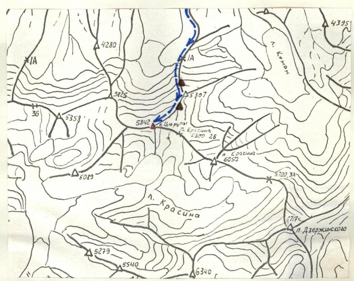
- Object of ascent — Peak Tsyurupa 5842 m, first ascent via the northern edge
- Estimated difficulty category — 5A
- Route characteristics:
| height difference | 2000 m |
| average steepness | 35–40° |
length of sections:
- II difficulty category — 2200 m
- III difficulty category — 260 m
- IV difficulty category — 550 m
- V difficulty category — 620 m
- Pitons hammered in for belay:
ice — 27 pcs., rock — 4 pcs.
- Number of travel hours — 20 h
- Number of overnight stays — 3 (in convenient places)
- Group composition:
Vlasov Viktor Akimovich — MS, leader Petiforov-Severov Valery Nikolayevich — MS, participant Lavrinenko Vyacheslav Lavrentyevich — MSMK, participant Plyshevsky Mikhail Alexandrovich — MS, participant Ivanova Tatyana Vasilievna — CMS, participant Savinkin Vladimir Nikolayevich — 1st sports rank, participant 10. Team coach: Honored Master of Sports Ovchinnikov Anatoly Georgievich 11. The group started the route on July 9 and returned on July 12, 1979.
I. Brief geographical characteristics of the region
Description of the object of ascent
Peak Tsyurupa was first mapped by an expedition led by N.V. Krylenko and named after a prominent figure of the Communist Party and the Soviet state — Alexander Dmitrievich Tsyurupa (1870–1928).
Peak Tsyurupa is located in the Zaalaysky Ridge west of Peak Krasin and has a height of 5842 m above sea level.
The eastern slopes of the northern edge drop off to the Koman Glacier, which gives rise to the Koman-su River. To the south of the summit is the cirque of the Krasin Glacier, and to the north is an unnamed glacier.
The northern ridge is composed of sedimentary rocks — shales and siltstones — with thin interlayers of harder hydrothermal veins. The rocks are significantly weathered.
There is no information about ascents to Peak Tsyurupa. Observations of the route were mainly conducted from a helicopter. Reconnaissance was facilitated by the fact that a helicopter route passes through this area, connecting the base camp of the International Alpine Camp "Pamir" at Achik-Tash with its branch at Fortambek.
The ascent was made by a team of coaches from the MAL "Pamir" with the goal of studying the area and scouting new climbing routes.
The team was airlifted to the route from the base camp at Achik-Tash by a Mi-8 helicopter (15 minutes of flight time).
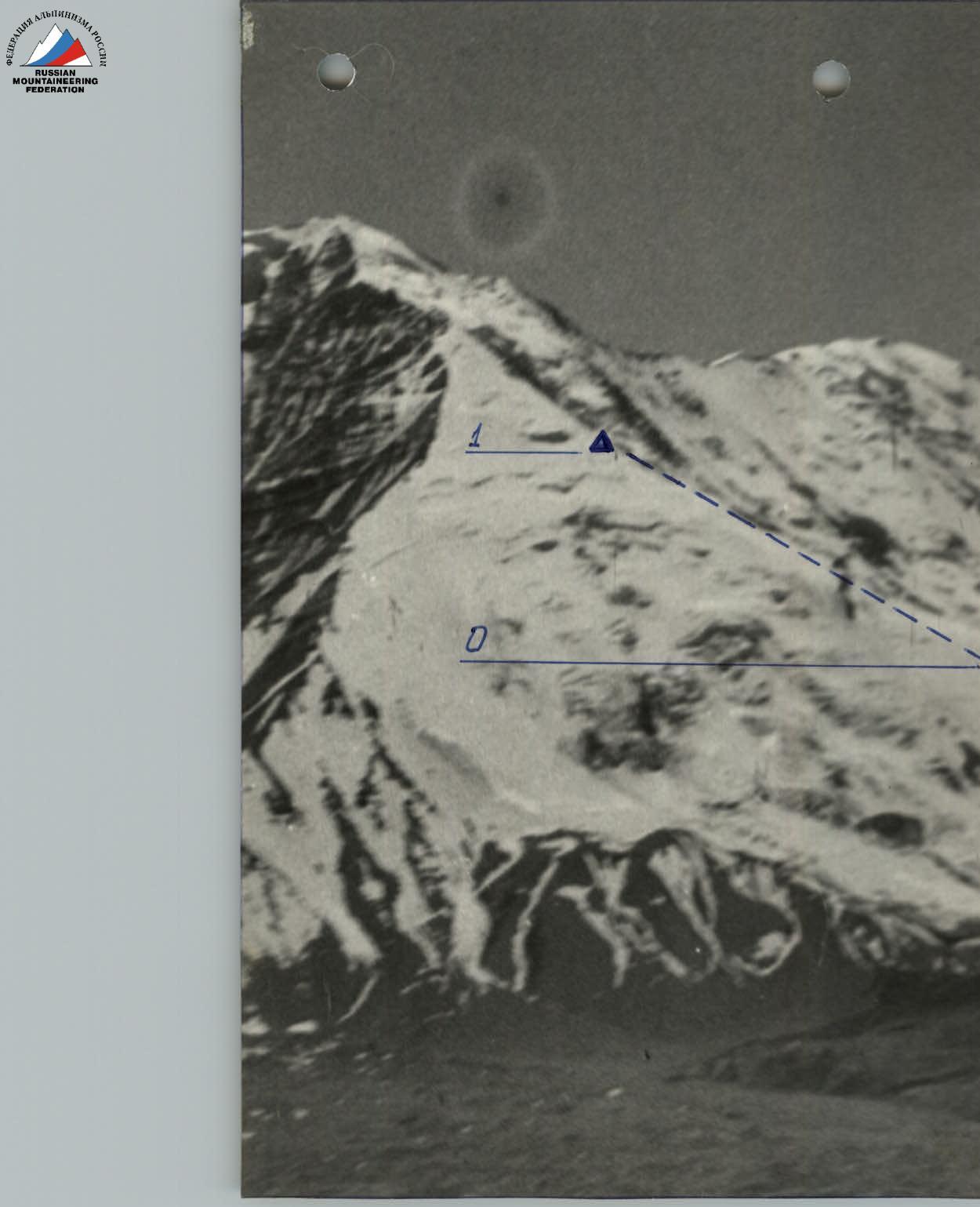
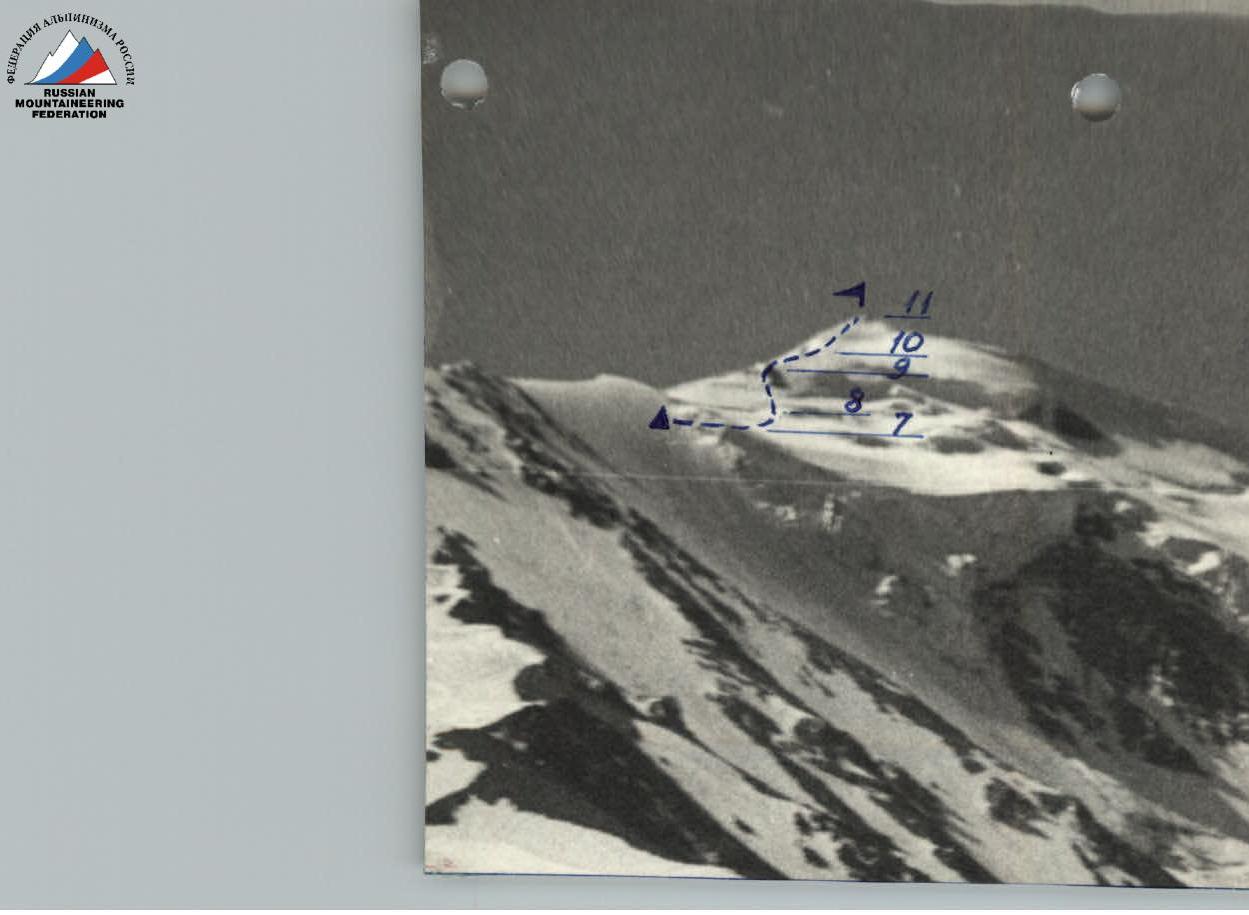
Schematic diagram of the first ascent to Peak Tsyurupa 5842 m via the northern edge
 → route of movement
▲ overnight stays
→ route of movement
▲ overnight stays
II. Preparation and organization of the ascent
Team formation
The team was formed on the basis of coaches from MAL "Pamir-79", who worked under Peak Lenin in the Achik-Tash gorge. The team's overall physical and special training was conducted according to a year-round training program under the guidance of the head of the training department of MAL "Pamir", Honored Coach of the RSFSR, Honored Master of Sports Ovchinnikov A.G.
By the time they started the route, all participants had undergone training in overcoming snowy-icy slopes and had sufficient acclimatization. The team composition is as follows:
- Vlasov V.A. — MS, leader
- Petiforov-Severov V.N. — MS, participant
- Lavrinenko V.L. — MSMK, participant
- Plyshevsky M.A. — MS, participant
- Ivanova T.V. — CMS, participant
- Savinkin V.N. — 1st sports rank, participant
The tactical plan for the ascent was as follows:
- 1 day — traversing the lower part of the northern ridge to an altitude of 4600–4700 m.
- 2 day — traversing the upper part of the northern ridge and emerging under the summit.
- 3 day — ascending to Peak Tsyurupa and beginning the descent.
- 4 day — descending via the ascent route.
The working conditions of the coaches in the camp required a minimal time for completing the route, which led to a condensed schedule for the route.
The planned tactical plan for the ascent was largely adhered to.
III. Description of the ascent route
Route progression
1 day (July 9). At 7:00, the group was airlifted from the base camp at Achik-Tash to the route by a Mi-8 helicopter and began ascending the northern ridge.
Small "gendarmes" encountered on the ridge are passed with easy climbing.
For the first overnight stay on the route, approximately at an altitude of 4600–4700 m, a few meters below the ridge, a platform was cut out for one high-altitude tent.
2 day (July 10). From the overnight stay, movement was on crampons in rope teams with alternating belays along the snowy-icy ridge with a steepness of 30° (2.5 ropes). Further, 3.5 ropes with piton belays on an icy slope with a steepness of 35° lead to the base of a rocky bastion. This section was processed the day before. During the time that had passed since the last reconnaissance, the conditions on the route had changed — snow had melted, revealing ice. From then on, the first person always went without a backpack. The bastion is bypassed on the right along an icy slope with a steepness of up to 40° with alternating ice and rocks, with careful piton belays (4 ropes). When emerging onto the rocks, special caution is necessary due to rockfall danger — this is the first key point of the route. After bypassing the rocky bastion, the route along the ice with a steepness of up to 35–40° in places leads to rocks at the junction of the northern and northeastern ridges (4 ropes). Piton belays are necessary. This is the second key point of the route. 100 m above the junction of the ridges, a control cairn was left. Further, the ridge becomes less steep, reaching 30°. Further movement along the ridge is complicated by cornices on the left, which hang over the entire remaining ridge, characteristic of this area with prevailing westerly winds. Three ropes from the control cairn, having passed two rocky pinnacles with accreted ice to a point where the ridge becomes less steep, the group cut out a platform in the snowy-icy slope for one tent. The platform is located 10 m below the ridge due to the presence of cornices.
3 day (July 11). From the overnight stay, along the icy ridge with a steepness of about 25° — 4 ropes to an icy dome. This section was processed the day before. On the left, there are cornices. On the icy dome, the route deviates from the ridge to the right and passes along the pre-summit icy slope with a steepness of 35–40° with piton belays to a group of rocky outcrops having a general triangular shape (4.5 ropes). Further, there is an exit to the left part of the triangle and then to the pre-summit ridge. Again, there are cornices on the left. After 3 ropes along the snowy-icy ridge, in places with a steepness of up to 45°, there is an exit to the icy dome of the Zaalaysky Ridge — the third key point of the route. Further along the snow, the path will lead to rocks that form the summit. To the southeast from the summit, slopes lead to a snowy plateau towards Peak Krasin.
Descent was via the ascent route with piton belays to the second overnight stay.
4 day (July 12). Descent under the start of the route via the ascent route. To the first overnight stay, the last participant always went without a backpack. The nature of the snowy-icy work on the route is similar to the ascent to the Ullu-tau-chan peak — the route "on the board". However, this route differs in greater length and height with similar steepness.
The ascent took place in stable good weather in the first half of the day and unstable weather in the second half.
It should be noted that a radio station of the "20 RPT 'Lastochka'" type does not provide radio communication with the base camp at Achik-Tash during the ascent. Stable radio communication was maintained with a group on the route to Peak XIX Party Congress.
| Date | Designation | Average steepness in ° | Length in m | Terrain character | Difficulty | Condition | Weather conditions | Rock pitons | Ice pitons | Notes |
|---|---|---|---|---|---|---|---|---|---|---|
| 09.07 | R0–R1 | 30 | 2200 | ridge | 2 | destroyed rocks | good, stable | Height difference 1100 m | ||
| 10.07 | R1–R2 | 30 | 100 | icy slope | 3 | ice | good | Height difference 500 m | ||
| R2–R3 | 35 | 150 | icy slope | 4 | ice | good | 1 | 3 | — | |
| R3–R4 | 40 | 160 | icy slope | 5 | ice | good | 2 | 4 | — | |
| R4–R5 | 40 | 160 | icy slope | 5 | ice | good | 6 | |||
| R5–R6 | 35 | 180 | ridge | 4 | ice | stable | 4 | — | ||
| R6–R7 | 30 | 120 | ridge | 4 | rocky pinnacles, cornices | stable | 1 | 1 | — | |
| 11.07 | R7–R8 | 25 | 160 | ridge | 3 | ice, snow, cornices | good | 1 | Height difference 400 m | |
| R8–R9 | 40 | 180 | icy slope | 5 | ice | good | 4 | — | ||
| R9–R10 | 30 | 100 | slope | 4 | icy slope | good | 2 | — | ||
| R10–R11 | 45 | 120 | ridge | 5 | ice, snow, cornices | good | 2 | — |
Height difference 2000 m. Number of travel hours to the summit — 20. Average steepness 35–40°. Pitons hammered in for belay:
- ice — 27 pcs.
- rock — 4 pcs. Number of overnight stays — 3 (in convenient places). Length of sections:
- II difficulty category — 2200 m
- III difficulty category — 260 m
- IV difficulty category — 550 m
- V difficulty category — 620 m