
Report on the First Ascent by the ITMO Sports Club Team to the Summit 4729 (Peak ITMO University — new name) via the Western Ridge of the North Wall.
Estimated difficulty 2B, Saint Petersburg, September 2017
Ascent Passport
- Ascent Area
Pamir-Alay, Achik-Tash gorge
- Summit 4729
- Route
- Ascent Class
- Height Difference:
- Team
Eastern 4729, Western
via the western ridge of the northern wall, estimated 2B category of difficulty
technical 860 m, length 2500 m ITMO Sports Club Saint Petersburg
- Team Composition
- Climbing Leader
- Route Characteristics: ascent to the pass from the foot — height difference — 150 m;
length — 400 m; pass — Western Summit: height difference 680 m
Veiko V.P., CMS in mountaineering, Orudzhev A.A., CMS in mountaineering, Veiko V.P., CMS in mountaineering
western summit — eastern summit:
- height difference −30 m
- length — 500 m
descent via the ascent route
length — 1600 m
- challenging sections
III category of difficulty — 90 m
-
number of walking hours
-
belay points
-
weather conditions
-
dates
10:00 (with overnight stay under the pass and return to the overnight stay)
ice screws — 5, закладки — 3, good
Departure from overnight stay — July 25, 07:00, western summit — 14:00, eastern summit — 14:40, return to overnight stay — 17:00
- Estimated Difficulty 2B
- Person Responsible for the Report — Orudzhev A.A.
1. Report Content:
-
Description of the Ascent
-
Table of Route Sections
-
Analysis of the Ascent
-
Copies of notes left on the summit
-
Contact Information
1. Description of the Ascent
Section R0–R1. Ascent to the pass between the Konokdzhilga and Aryndzhilga river valleys.
From the overnight stay under the pass, ascend to the pass via a scree slope. The scree is finer. In the early hours, the upper layer of the scree may harden, preserving the ascent tracks. Ascent is possible with trekking poles.
Section length — 400 m. Slope — 15°. Difficulty category — n/c
Section R1–R2. Ridge with gendarmes
From the pass, move along the ridge with gendarmes. The gendarmes are bypassed on the right via scree sections.
- At the end of the section, there is a rock ascent
- Simultaneous belay via outcrops
Section length — 300 m. Slope — 20°. Difficulty category — II
Section R2–R3. Rock Ascent
The rock ascent is climbed via free climbing. Belay via закладки. It is possible to bypass the ascent via ice on the left with belay via ice screws.
Section length — 40 m, slope — 45°, difficulty category — III
Section R3–R4. Ridge
A gentle section of the ridge up to the second rock ascent. Simultaneous belay.
Terrain characteristics — snow slope.
Section length — 300 m, slope — 15°, difficulty category — n/c
Section R4–R5. Second Ascent
The second rock ascent is climbed via the ice slope on the left of the rocks. Belay via ice screws. The first person ascends with front-pointing crampons and an ice axe or axe-hammer. It is possible to climb the section via rocks.
Section length — 50 m, slope — 45°, difficulty category — III
Section R5–R6. Ridge to the western summit
A gentle section of the ridge to the western summit.
- Simultaneous belay
- Possible independent movement without a rope
- Terrain characteristics — snow slope
Section length — 900 m, slope — 10°, difficulty category — n/c
Section R6–R7. Ridge to the eastern summit
A gentle section of the ridge to the eastern summit.
- Simultaneous belay
- Possible independent movement without a rope
- Terrain characteristics — snow slope
Section length — 500 m, slope — 5°, difficulty category — n/c
Descent via the ascent route 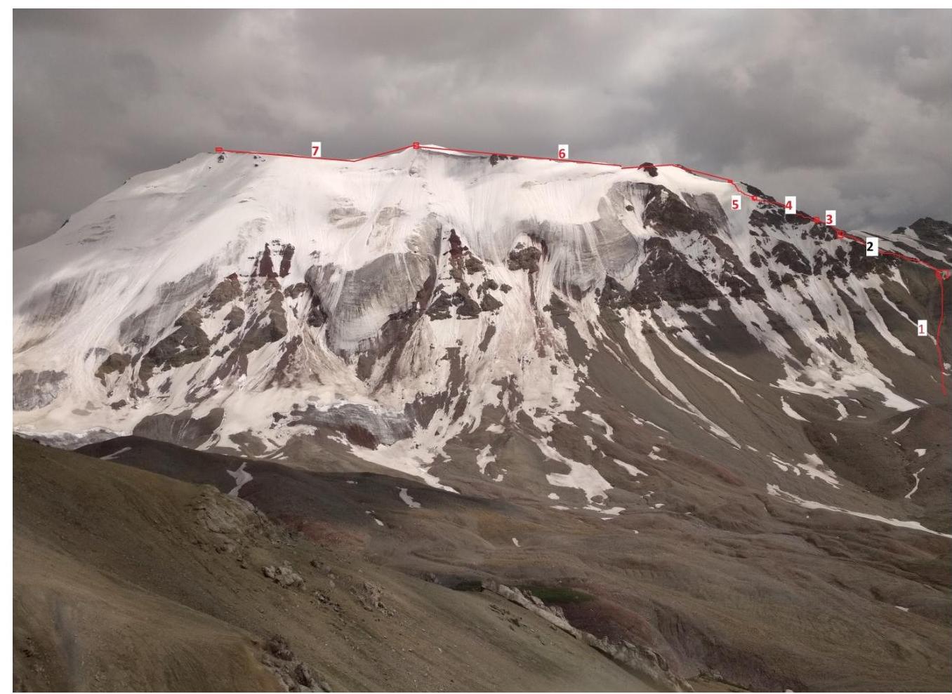
- Table of Route Sections.
| Section # | Rock Pitons | Ice Screws | ITO | Length, m | Slope, degrees | Difficulty | Notes |
|---|---|---|---|---|---|---|---|
| 0-1 | - | - | - | 400 | 15 | n/c | |
| 1-2 | - | - | - | 300 | 20 | II | |
| 2-3 | 3 | - | - | 40 | 45 | III | |
| 3-4 | - | - | - | 300 | 15 | n/c | |
| 4-5 | - | 5 | - | 50 | 45 | III | |
| 5-6 | - | - | - | 500 | 5 | n/c | |
| 6-7 | - | - | - | 500 | 5 | n/c |
3. Analysis of the Ascent
Veiko V.P.: — The main difficulty of the first ascent was finding an optimal route to the unnamed summit. This was achieved during reconnaissance trips:
- from the south from the Kok-chhur river valley
- from the north from the Konok-dzhilga river valley
It was also noted that an emergency descent to the south is possible from almost any point on the route. The found route is logical. Its relatively low difficulty is natural for a first ascent. The route is easy to find, and its passage is possible even in poor visibility. The two climbers worked efficiently and in harmony. On the summit, a photo was taken, a cairn was built, and a note was left.
The ascent reminds me very much of the ascent to Peak Petrovsky 4731 m in 2015, which is located nearby, symmetrically on the other side of the Achik-Tash gorge — similar in height, terrain characteristics, difficulty, and effort required. Of course, a first ascent is always a first ascent — you never know what you'll encounter — this is part of its additional difficulty and charm.
Orudzhev A.A. — The route is interesting. This is my first first ascent. The views of the slopes of Peak Lenin and the surrounding massifs in good weather are impressive. The bridge built in 2016 across the Achik-tash river will allow for training ascents to the summit as part of the ascent to Peak Lenin. A well-prepared team can make a one-day ascent from the base camp on Lukovaya Polyana without an intermediate overnight stay under the pass.
4. Contact Information
Veiko Vadim Pavlovich Tel. +7 921 745–76–24 vadim.veiko@mail.ru
Orudzhev Alexey Tel. +7 960 249-86-66 aorud@mail.ru
Comments
Sign in to leave a comment