
4.4.72
Ascent to Peak Ya.M. Sverdlov via the northern ridge (1B cat. diff.).
Trans-Alai Range, Pamir. 1967.
Description compiled by V. Masyukov.
1. Introduction
In the summer season of 1967, a comprehensive high-altitude mountaineering expedition of the MGS SDSO "Burevestnik" took place in Pamir. Over the course of July and August, the expedition participants carried out a series of ascents in both the Pamir region and Tian Shan.
Before commencing work in Tian Shan, a 10-day training and acclimatization gathering was held in the area of the "Ala-Archa" mountaineering camp, which greatly benefited the subsequent high-altitude ascents. After completing a jubilee ascent in honor of the 50th anniversary of the Great October Revolution to Peak Lenin, the expedition relocated to the district center of Darut-Kurgan, from where the participants were to be airlifted by helicopter to the upper reaches of the Forgambek glacier beneath the Big Pamir Firn Plateau, with plans to ascend to the plateau from the north and climb Peak Kommunizma via a new route.
Looking ahead, it can be said that this plan was not fully realized due to circumstances beyond the control of the expedition participants. The "Burevestnik" mountaineers pioneered a path to the Big Pamir Firn Plateau from the north and also assisted a parachute landing party that made a unique group jump onto the plateau at an altitude of 6000 m.
Thus, the delay with the helicopter in Darut-Kurgan and the established weather conditions allowed two groups of mountaineers from the expedition to ascend Peak Ya.M. Sverdlov from the Alтын-Dara valley via a new route.
2. Geographical Overview of the Ascent Area
Peak Ya.M. Sverdlov (5541 m) is situated in the lateral northwestern spur of the Trans-Alai Range in the northwestern Pamir. This lateral spur is bounded to the north by the picturesque Alai Valley, stretching over 100 km in length and more than 20 km in width, and the swift Kyzyl-su River. In the meridional direction, the spur is bounded from the west by the Alтын-Dara gorge and river (of the same name), which originates from the Ters-Agar pass and flows into the Kyzyl-su River opposite Darut-Kurgan - the administrative center of the high-altitude Chong-Alai district.
In 1962, mountaineers from the city of Sverdlovsk first ascended the 5541 m peak from the east, naming it after the remarkable revolutionary Ya.M. Sverdlov. The Moscow "Burevestnik" mountaineers ascended Peak Ya.M. Sverdlov from the Alтын-Dara valley via the northern ridge.
- See photo 2.
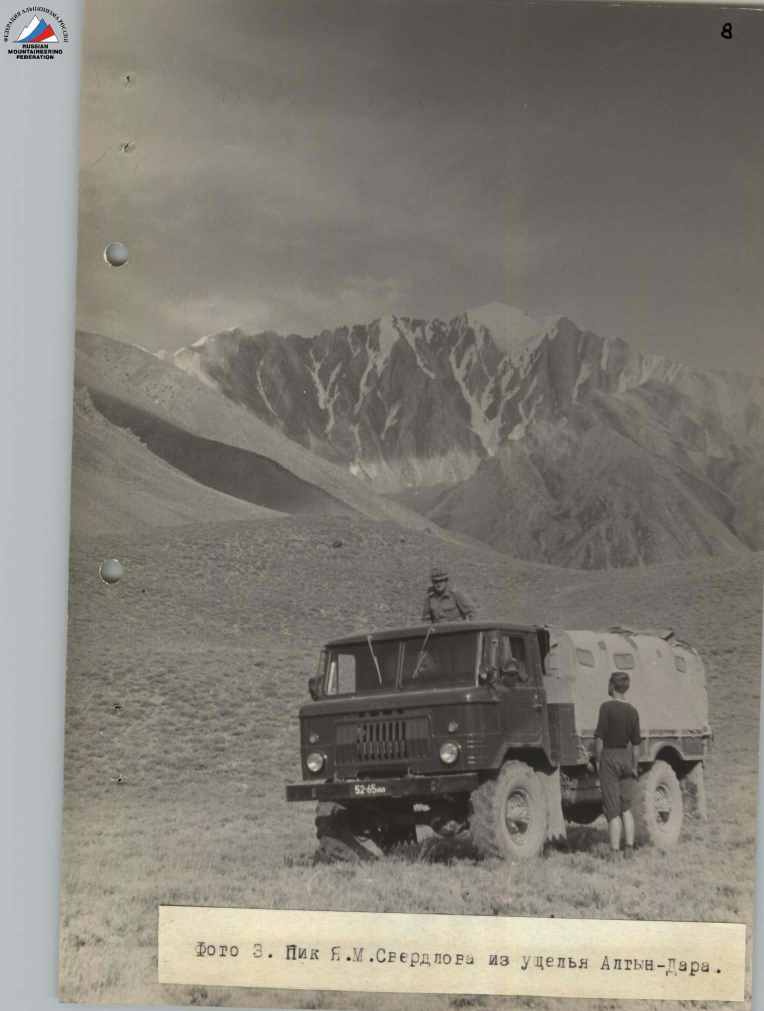 Photo 2. Cartographic diagram of the ascent area. Paths leading to Peak Sverdlov.
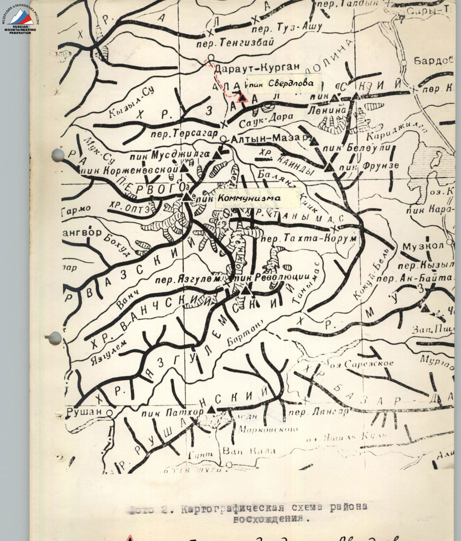 Photo 3. Peak Ya.M. Sverdlov from the Alтын-Dara valley.
3. Description and Characteristics of the Route
After crossing the turbulent Kyzyl-su River near the settlement of Darut-Kurgan via a suspension bridge, one should slightly return downstream along Kyzyl-su to the confluence of the Alтын-Dara River and ford to the right orographic bank.
The road runs along the river until farms are reached, located on the left-hand slopes of the hills. The automobile road turns left, bypassing a grassy hill, while the trail above the river canyon bypasses it on the right. About an hour and a half later, we again reach the motor road and follow it until the confluence of the gorge leading to the foot of Peak Sverdlov into the Alтын-Dara valley.
Along the trail, past a cattle pen, on the right orographic side of the stream originating from the upper cirque of Peak Sverdlov, we reach a yurt. From there, veering slightly left with a minor traverse of the grassy slope, we ascend to the steep, crumbling bank of the stream, and then proceed via scree to the canyon.
At the narrowing of the riverbed, within the rocky canyon, we cross the stream and, after another 15 minutes, cross back to the same side. One hour later (counting from the last yurt), we reach the final grassy section, very suitable for a bivouac.
The departure from this campsite should be made early in the morning. The extremely fractured rocks and slate scree, through which one must navigate to reach the western ridge and then the northern one, demand caution and attention. Five hours later, we reach the western ridge.
The western ridge presents no significant technical difficulty until the junction with the main northern ridge, except that just before reaching the northern ridge, one must overcome an ice-firn slope with a slope angle of up to 50° and a length of about 2–3 ropes.
From the western ridge, the main northern ridge is visible (see photo 5).
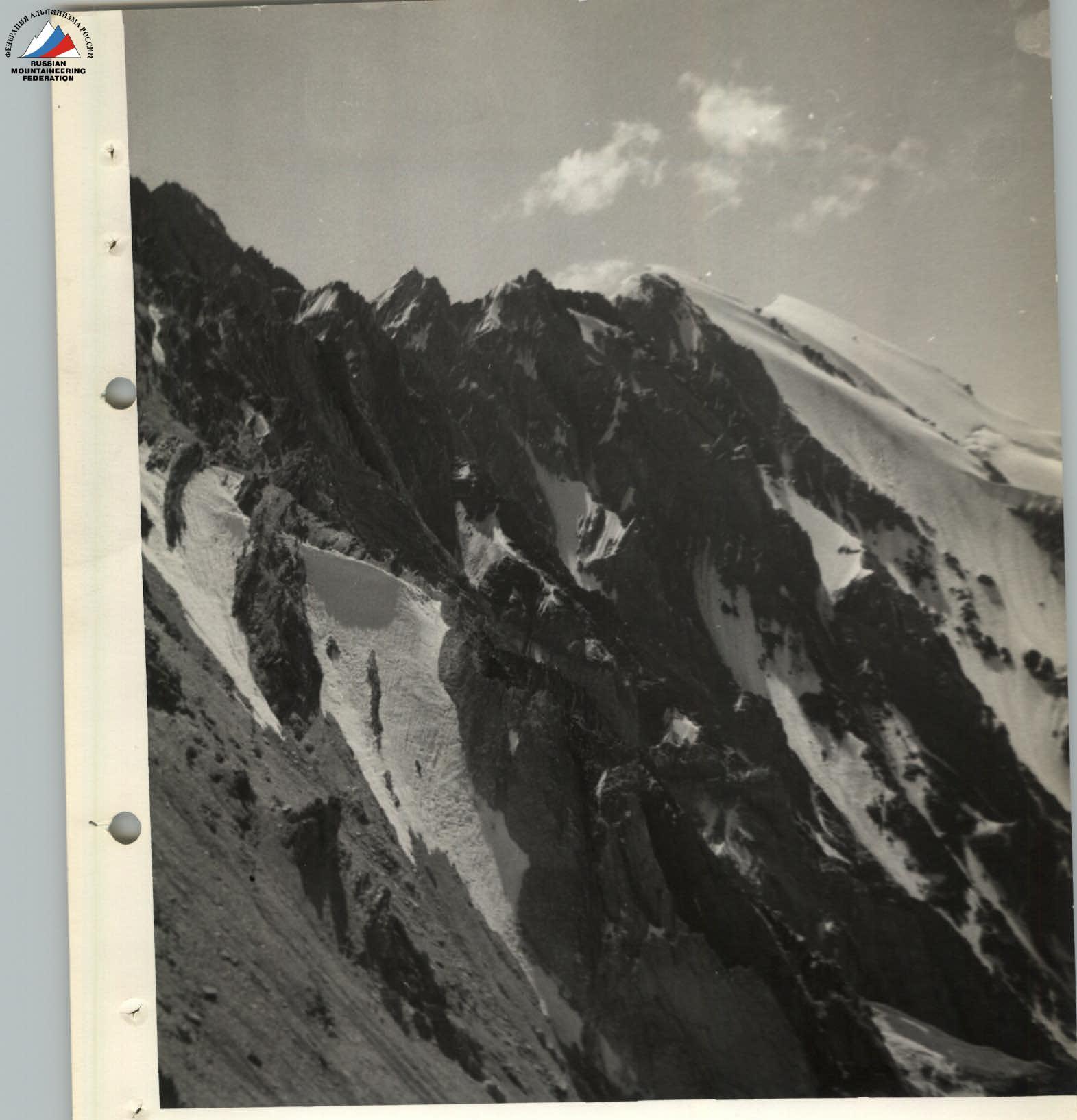
Photo 5. The northern ridge of Peak Sverdlov from the western ridge.
From the junction of the ridges, the further path can be observed, with almost all sections visible. (See photo 6) To exit directly onto the northern ridge, we:
- descend slightly left into a scree couloir. Piton protection is necessary!
- after two ropes, almost at the head of the couloir, a diagonal descent is made (1 rope).
- then traverse right and upwards.
- exit via scree onto the fractured ridge.
After proceeding along the ridge for about 2 ropes (this section is traversed simultaneously!), the group encounters the first serious section, a rocky, fractured ascent, snow-covered at the base. It should be noted that movement along the route is restricted to the ridge due to the extremely fractured, steep slopes. In most cases, bypassing numerous pinnacles is not feasible.
Overcoming the ice-snow section (which may be icy in the second half of summer), between two large boulders, we ascend (using combined protection) and continue along the rocky crest towards a crescent-shaped snow depression.
A grey-red pinnacle, resembling two feathers placed side by side, is overcome with piton protection. From the saddle beneath the pinnacle, we descend slightly right (half a rope, caution due to loose rocks!), then ascend and continue along a light, monolithic slab (up to 90°) to a ledge at the top of the pinnacle (1 rope). Along this ledge, we bypass the pinnacle on the right and continue along the ridge.
- The next pinnacle is taken head-on; deviating left should be avoided to prevent encountering accreted ice.
- The third pinnacle is higher than the second (2 ropes), but the climbing is not as difficult.
- The fourth pinnacle is visible in the photograph. The path through it lies on the boundary between the rocks and the snow cornice, requiring great caution and attention.
From this pinnacle, the ridge turns sharply left, but after 2–3 ropes, it again heads towards the forepeak.
- The ascent to the 'bull' pinnacle involves traversing snow-covered rocks of moderate difficulty, with combined protection.
- The descent from this pinnacle and further progress along the ridge are complicated by extremely fractured rocks; the ridge is very narrow in places, requiring some sections to be traversed while seated astride the crest.
- Protection in these areas involves using outcrops with either ice or long profile pitons.
- During the descent to the saddle before the next pinnacle, the group was forced to leave a fixed rope, which facilitated the descent.
On the return journey, the left rope proved very useful since the descent followed the ascent route.
The approach to the 6th pinnacle from the saddle involves traversing snow-covered rocks. The climbing is difficult, requiring piton protection. This section ends in a rocky-ice couloir, crossing which demands extreme caution from the climbers due to potential rockfall.
Further:
- Traverse the base of the 6th pinnacle, bypassing it on the left.
- Ascend along a ledge.
- Overcome a small slab (2–4 m) and exit onto the snowy crest of the pinnacle.
- Then, another descent to another saddle, via несложным, but разрушенным скалам.
After proceeding about five ropes and overcoming two more small pinnacles, we reach a wall with a slope angle of up to 70–80°, the second part of which is covered in ice and snow. The total length of this section is 2 ropes.
Organizing protection is complicated by the lack of suitable protection points on the extremely fractured, debris-covered wall. Only ice pitons and profile pitons are used.
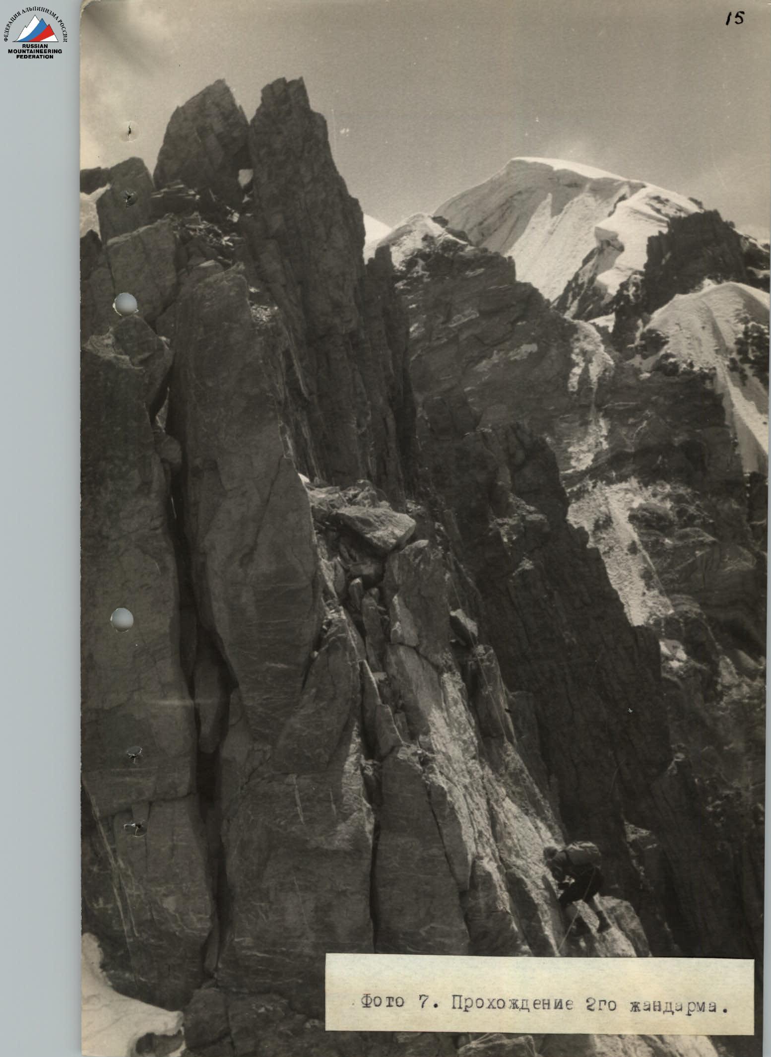 Photo 7. Passage of the 2nd pinnacle.
Further:
- Traverse, heading right and upwards along a snow-ice slope.
- Then, along a flattening firn slope, exit onto the forepeak, representing a snowy dome with large cornices on the left.
Five ropes later, we approach a rocky spire rising in the middle of the forepeak plateau. The group reaches this location around 17:00.
Further, having removed their backpacks, the climbers lightly ascend the forepeak rise and, after 2 hours of walking, reach the summit.
The "Burevestnik" group descended via the ascent route and, due to underestimating the difficulty of the route, failed to descend in daylight to the bivouac set up on the western ridge, and spent the night on the main northern ridge without a tent.
The next day, the group descended to a grassy clearing in the cirque of Peak Sverdlov's glacier by 11:00 am and, having descended into the Alтын-Dara valley, returned to Darut-Kurgan.
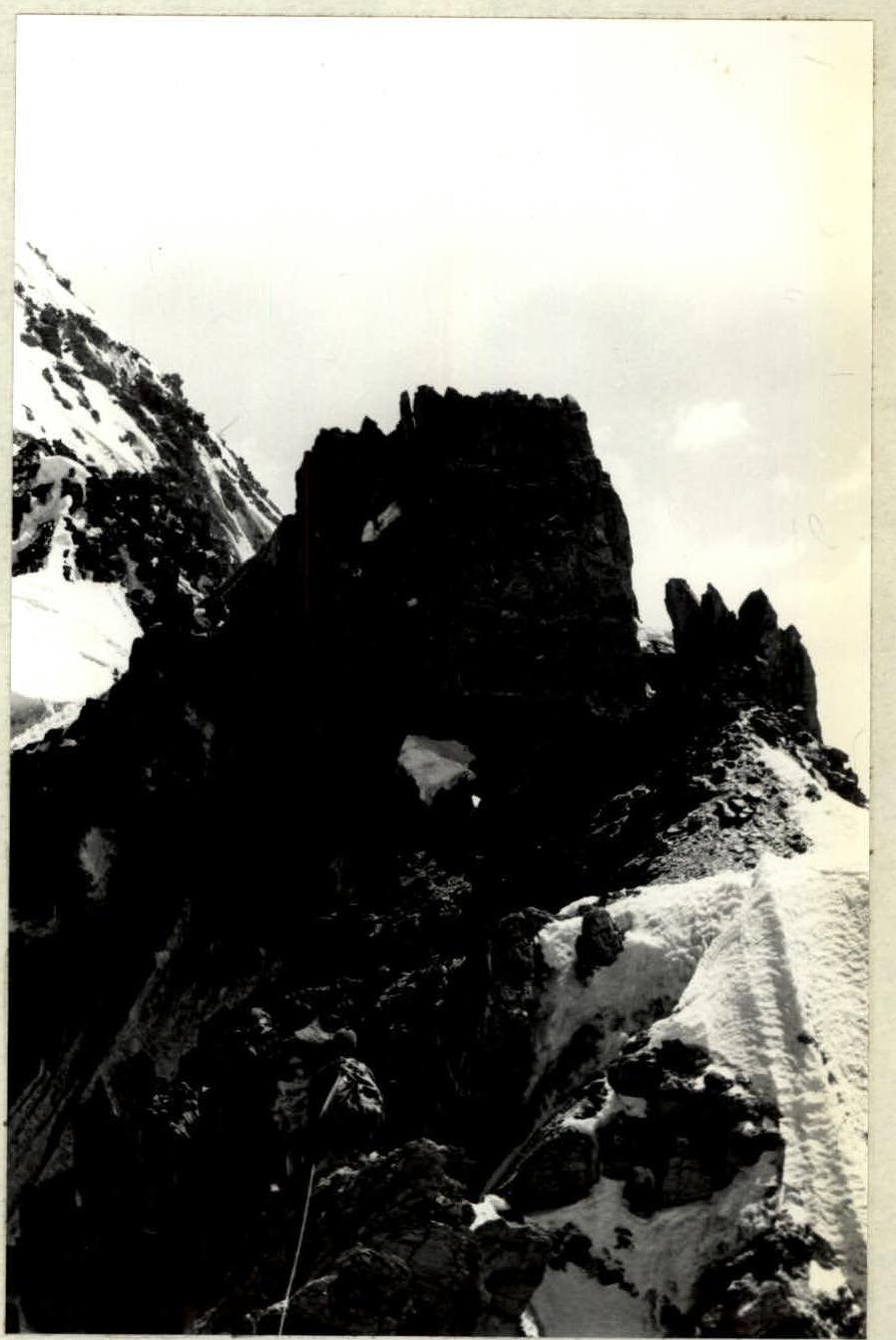 Photo 7a. Section of the northern ridge before exiting to the 6th pinnacle.
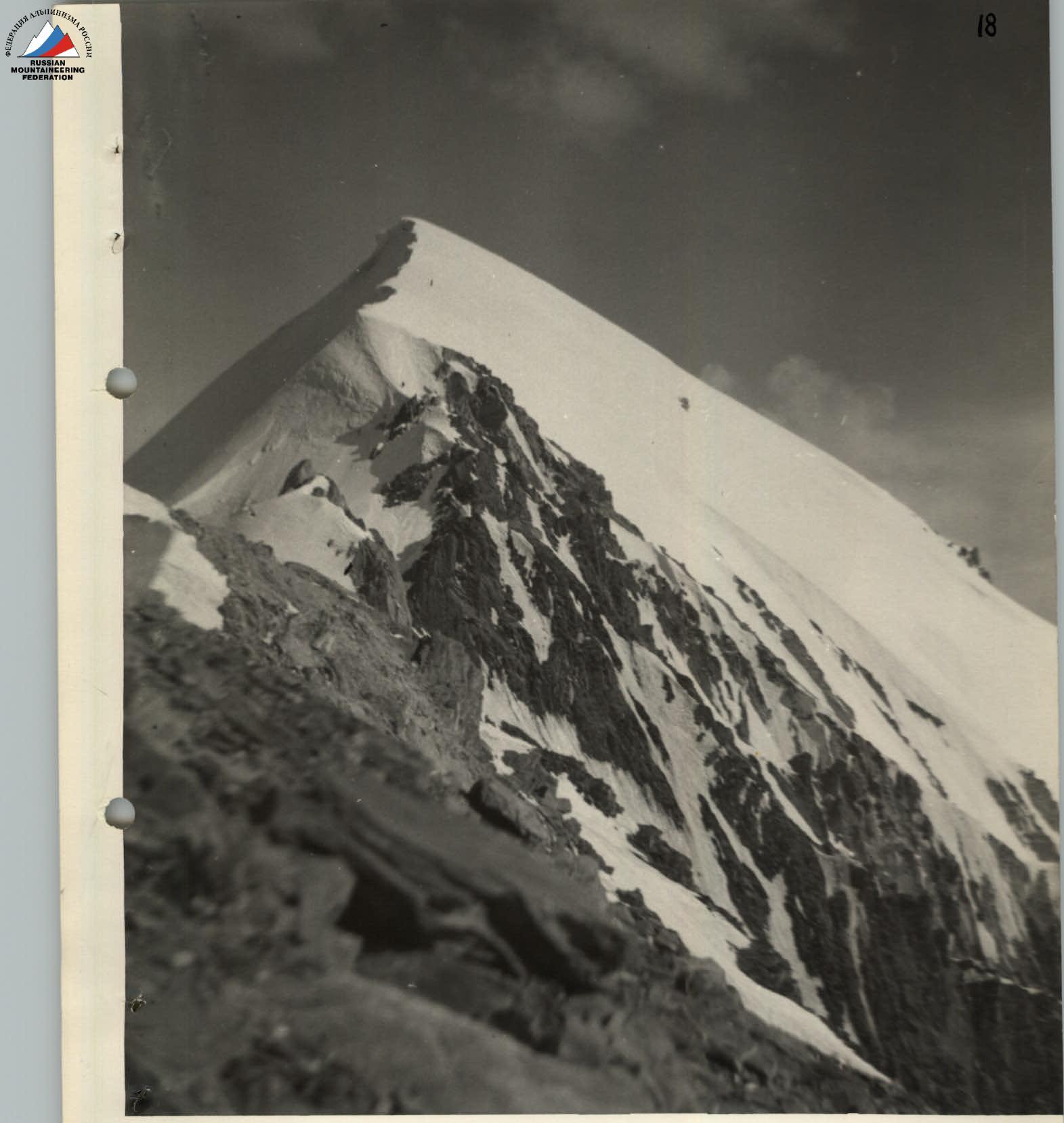 Photo 8. Forepeak ascent of Peak Sverdlov.
4. Route Assessment
Preliminary consultations and visual examination of the route initially suggested an approximate assessment of the intended ascent as 4B cat. diff. The actual ascent provided further clarity on this matter.
Additionally, the classified traverse of the six towers of the Corona (B cat. diff.) during the training gathering in the "Ala-Archa" mountaineering camp area allowed for a comparison between the two routes.
The route taken to Peak Sverdlov via the northern ridge, considering the specifics of this area, can justifiably be classified as a 1B cat. diff. route.
- Similarly, one can compare the Caucasian route 1B cat. diff. traverse of Dzhuguturluchat.
5. Wishes and Remarks on the Completed Route
-
The number of participants in the group should not exceed 4 people.
-
To ensure reliable protection, it is recommended to bring a sufficient number of long profile pitons (at least 10 pieces).
-
The group should have a pair of three-rung ladders.
-
All participants should have crampons, wearing boots with profiled soles (such as "Vibram").
-
Bivouacs should be set up as follows:
1st — on the last grassy clearing in the upper cirque of Peak Sverdlov,
2nd — before the junction of the western and northern ridges,
3rd — on the forepeak plateau near the rocky spire, where a control cairn is located (see photo 4).
-
Descent from the summit is recommended via the southern ridge, as it is less difficult.
-
The minimum number of days required for ascending Peak Ya.M. Sverdlov from Darut-Kurgan and returning is 5–6 days.
6. Composition of Groups that Ascended Peak Ya.M. Sverdlov via the Northern Ridge
1st group:
| Initials | Rank | Role | |
|---|---|---|---|
| 1. Borodkin | Yu.V. | CMS | Leader |
| 2. Dobrovolsky | L.N. | MS | Coach |
| 3. Skurlatov | Yu.I. | CMS | Participant |
| 4. Suloev | V. | CMS | Participant |
2nd group:
| Initials | Rank | Role | |
|---|---|---|---|
| 1. Masyukov | V.P. | CMS | Leader |
| 2. Bozhukov | V.M. | MS | Coach |
| 3. Kosmachev | O. | CMS | Participant |
| 4. Maximov | V.N. | 1st sports rank | Participant |
| 5. Shindyakin | A.P. | 2nd sports rank | Doctor-Participant |
Material prepared by: Masyukov V.P.
- Bozhukov did not complete the ascent, acting as a coach-observer.